
Mori Atlas logo
Nature reserveForêt relique de Niaouli

Tracing the geographic boundaries and ecological transition zones of a historic West African woodland refuge

Forêt relique de Niaouli Nature Reserve: Mapping the Protected Forest Remnants of Southern Benin

Forêt relique de Niaouli represents a critical protected woodland fragment located within the Atlantique department of southern Benin. This nature reserve serves as an essential reference site for forest ecology, featuring a distinct mix of lowland swamp forest along the Ava stream and dry plateau woodland bordering savanna landscapes. Its position near the Dahomey Gap offers significant insight into the distribution of tropical forest wildlife and plant communities across the regional terrain.

relic forestsemi-deciduous forestlowland forestplateau forestriparian habitatsavanna edge
An illustration of a tropical forest featuring tall white-barked trees, ferns, and vines, with a waterfall cascading down a distant cliff in the center at sunset.

Forêt relique de Niaouli

Nature reserve

Park overview

Structured park overview, official facts, and landscape profile for Forêt relique de Niaouli

Forêt relique de Niaouli park facts, protected area profile, and essential visitor context

Review the core facts for Forêt relique de Niaouli, including designation, size, terrain, visitor scale, habitats, and operating context in one park-focused overview.

About Forêt relique de Niaouli

Forêt relique de Niaouli is a protected woodland in the commune of Allada, in Benin's Atlantique Department, situated roughly 50 km inland from the economic capital of Cotonou. Despite its modest size, the forest has scientific, ecological, and historical significance that extends well beyond its immediate surroundings. It stands as one of the few surviving fragments of a once much wider semi-deciduous forest landscape that historically covered much of southern Benin.

The protected area is embedded within the Niaouli agricultural research station, founded in 1904 during the colonial period then known as the colony of Dahomey. This setting gives the site both a research heritage and a particular character: the forest is surrounded by agricultural experimentation plots and a long history of agronomic study, which has, paradoxically, also contributed to its preservation. While the surrounding region has been extensively cleared, the research station context has helped keep a meaningful block of forest standing.

Ecologically, the forest covers about 220 hectares, though only some 65 hectares still retain a relatively dense, undisturbed canopy. Two distinct habitats are recognized. The first, known as the lowland forest or forêt du bas fond, covers around 24 hectares near a stream called the Ava, and is seasonally or permanently flooded. The second is the plateau forest, or forêt du plateau, covering roughly 41 hectares on drier ground bordered by open savanna vegetation. The contrast between these two environments within a single small protected area gives the site an enriched ecological profile.

Niaouli's location in the southern coastal zone of Benin places it near the Dahomey Gap, a recognized biogeographic break in the West African forest belt. As a result, the forest has been used as a reference for studies of how tropical forest species respond to forest fragmentation, environmental gradients between dense forest and savanna, and the distribution of wildlife on either side of this dry corridor. The site is now used for research on flora, birds, bats, and butterflies, reinforcing its role as a compact but information-rich biodiversity reference point for southern Benin.

Quick facts and research context for Forêt relique de Niaouli

Forêt relique de Niaouli is a 220-hectare protected forest relic in southern Benin, in the Atlantique Department, on the territory of the commune of Allada and within the historic Niaouli agronomic research station founded in 1904. The protected area includes about 65 hectares of relatively preserved semi-deciduous dense forest, split between a permanently waterlogged lowland section irrigated by the stream called the Ava, and a drier plateau section surrounded by savanna. Floristic inventories have recorded 223 plant species across 72 families, while ornithological work has documented 166 bird species, of which 14 were recorded for the first time in Benin.

Protection and recognition

Terrestrial conservation framework and established designation records for Forêt relique de Niaouli.

Forêt relique de Niaouli Protection Status and Designation History

Documented protection status and designation history outline the terrestrial conservation framework established for Forêt relique de Niaouli in 1997. Official management scope details provide essential context for reviewing regional protected area records without additional international recognition sources.

Protection details

Protection scope
Terrestrial
Designated year
1997
Transboundary protection
No
Park context

Deeper park guide and search-rich context for Forêt relique de Niaouli

Forêt relique de Niaouli history, landscape, wildlife, and travel context

Explore Forêt relique de Niaouli through its history, landscape character, ecosystems, wildlife, conservation priorities, cultural context, and seasonal travel timing in a structured park guide built for atlas discovery and search intent.

Why Forêt relique de Niaouli stands out

Niaouli is best known as a remnant patch of dense semi-deciduous tropical forest that has survived intense agricultural pressure in one of Africa's most deforested coastal zones. The site is closely associated with the Niaouli agronomic research station, making it a long-standing reference site for forest ecology, ethnobotany, and conservation research in Benin. Its position near the Dahomey Gap also gives it scientific importance for understanding how forest wildlife and plant communities are distributed across the break between the West African and Central African forest blocks.
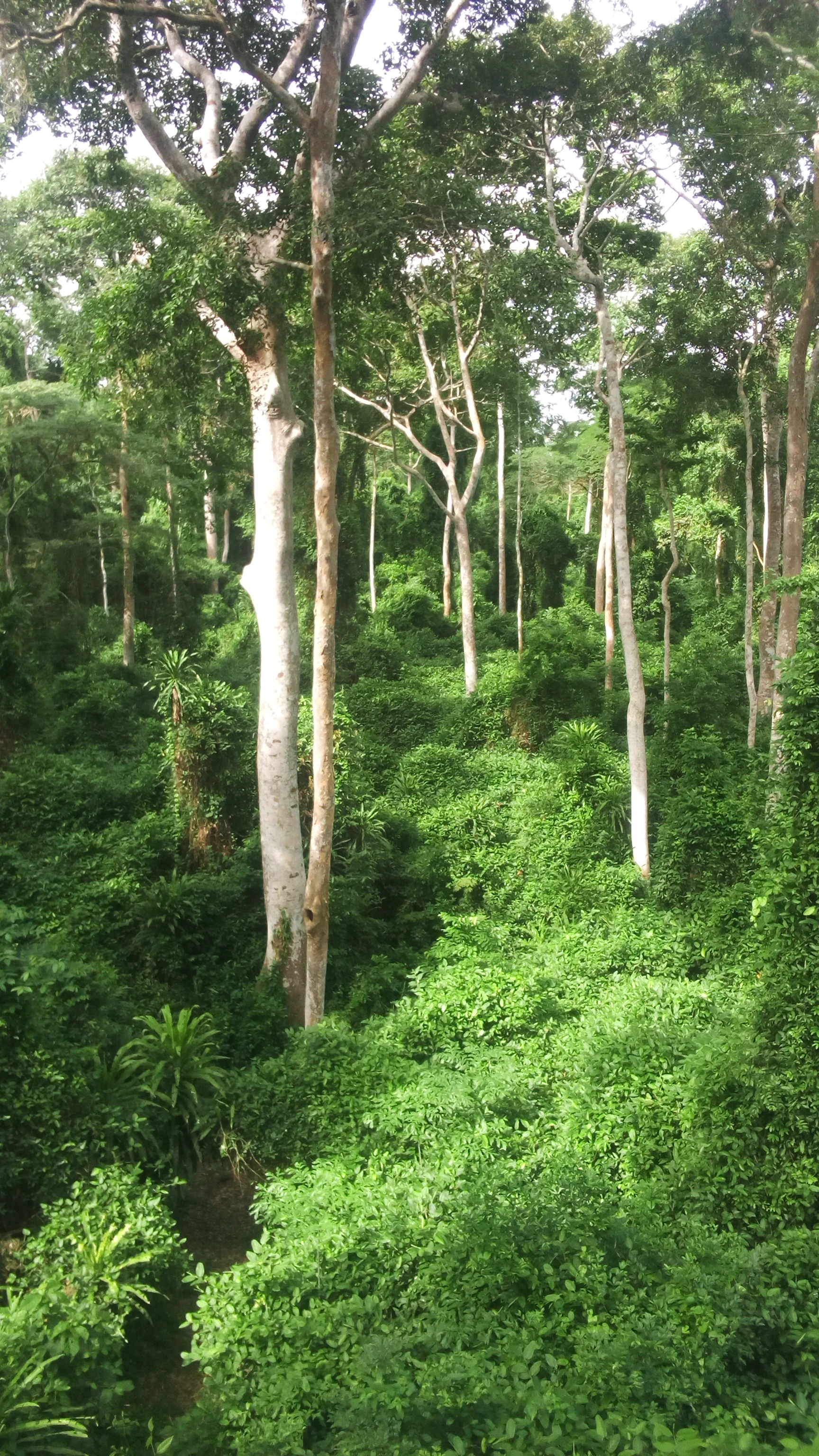
A high angle view looking down into a dense, lush green forest featuring several tall, pale-barked Iroko trees rising above the thick understory foliage.
A dense canopy of Iroko trees within the Forêt relique de Niaouli.

Forêt relique de Niaouli history and protected-area timeline

The forested portion that today forms the protected area has been preserved largely because of its location within the Niaouli agricultural research station, founded in 1904 in what was then known as the colony of Dahomey. The station is among the oldest scientific agricultural institutions in the country, and its establishment meant that a tract of natural forest was retained amid the surrounding farmland rather than converted to cultivation as happened elsewhere across southern Benin.

Over the decades, the forest lost some of its original extent as portions were progressively incorporated into the research station's experimental plots. The remaining dense forest is therefore described as a 'relict' forest, an island of native woodland surviving in a matrix of agricultural and savanna landscapes. Formal protection of the surviving forest came in 1997, when the area was officially designated as a protected natural reserve.

Since protection, the forest has been the subject of repeated scientific inventories covering plants, birds, bats, and butterflies. Ornithological work has been ongoing since 1997, and bat surveys were carried out in the early 2000s, helping establish Niaouli as an important reference for biodiversity research in southern Benin and for studies of the Dahomey Gap as a biogeographic feature of West Africa.

Forêt relique de Niaouli landscape and geographic character

The Niaouli forest occupies a relatively flat area within the southern coastal lowlands of Benin, with terrain shaped by the contrast between a seasonal watercourse and the surrounding plateaus of the Dagbe region. The total protected area covers around 220 hectares, but only about 65 hectares still carry a relatively intact dense forest cover, framed and partly isolated by experimental agricultural plots of the surrounding research station.

Two clearly defined landscape units make up the core forest. The lowland forest covers roughly 24 hectares around the Ava stream and is regularly or permanently inundated, giving it swampy and riparian characteristics typical of tropical lowland forest fragments in southern Benin. The plateau forest, covering around 41 hectares, sits above this wetter zone on drier ground and borders open savanna vegetation, producing a sharp ecotone between dense woodland and grass-dominated landscapes. This juxtaposition of wet lowland forest and drier plateau forest, all within a small reserve, gives the site much of its landscape interest and biological diversity.
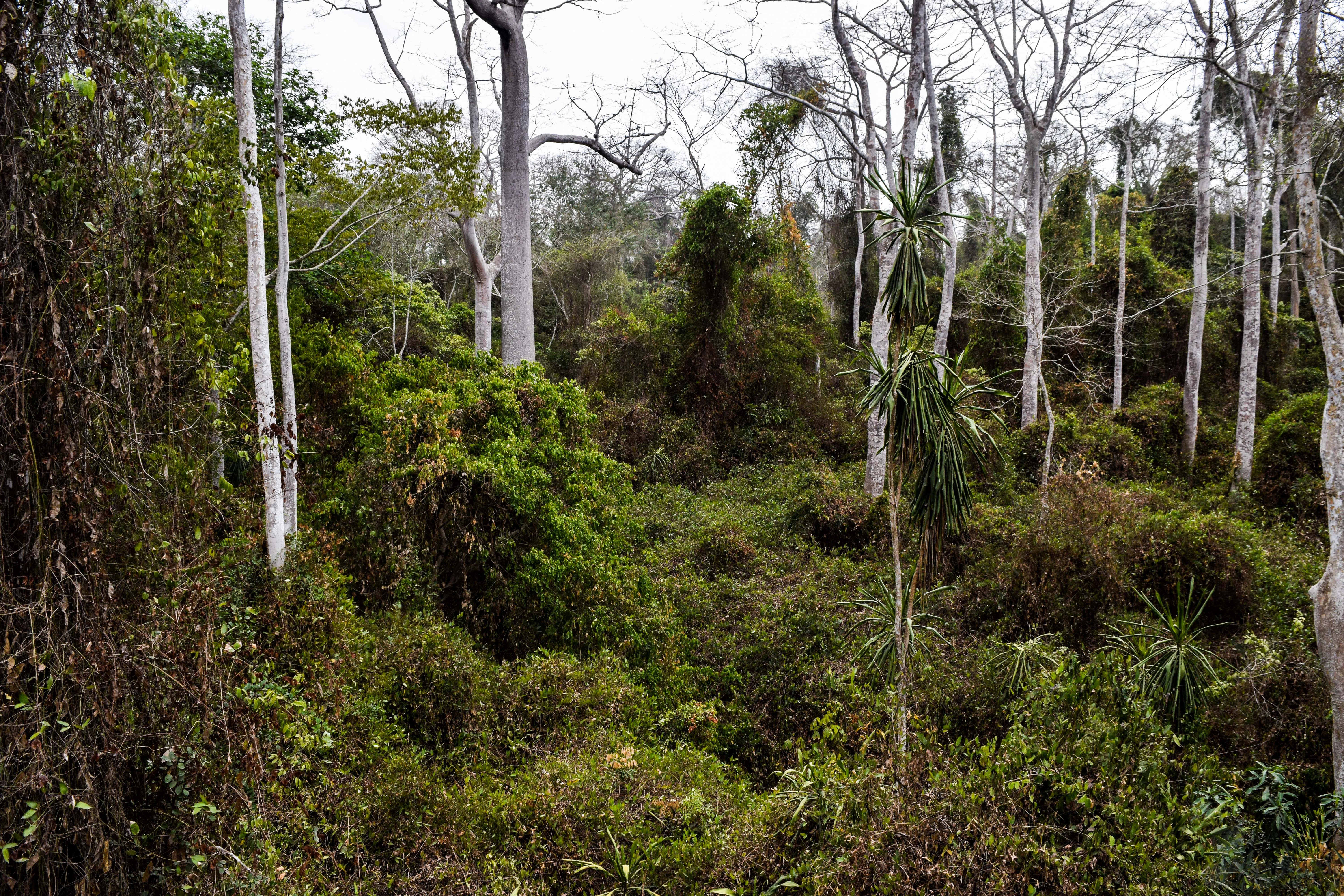
A dense forest interior featuring tall, pale-barked canopy trees rising above thick green undergrowth and climbing vines.
A view of the dense vegetation and towering canopy trees within the Forêt relique de Niaouli.

Forêt relique de Niaouli ecosystems, habitats, and plant life

Ecologically, Niaouli is a remnant of tropical semi-deciduous forest, a vegetation type that once dominated the southern part of Benin and adjacent regions. Although the surrounding territory is now largely agricultural or savanna, the reserve retains enough of the original structure, including a closed canopy, buttressed trees, and a continuous herbaceous layer, to preserve ecologically representative forest conditions for the region.

Botanical inventories have recorded 223 plant species distributed across 72 families, indicating a relatively rich flora for such a small woodland. These include species of recognized local value such as Albizia zygia, Antiaris toxicaria, Ceiba pentandra (the silk-cotton tree, locally known as fromager), and Newbouldia laevis, all of which are used by surrounding communities for timber, medicine, or food. The flora of the plateau and lowland sections differs in composition, reflecting differences in moisture, soil, and hydrology, which makes the site valuable for studying vegetation patterns at a small spatial scale.
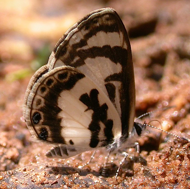
A close-up view of an Azanus isis butterfly resting on damp, reddish-brown soil, showing its patterned cream and dark brown wings.
A small butterfly perched on the ground in the Forêt relique de Niaouli.

Forêt relique de Niaouli wildlife and species highlights

The forest's wildlife has been documented in several targeted surveys, beginning with the ornithological investigations that started in 1997 and continuing with bat and butterfly work in later years. The bird list for Niaouli includes 166 species, of which 14 were recorded in Benin for the first time in the course of research at the site. These include nightjars, barbets, honeyguides, bulbuls, warblers, and a variety of forest-dependent passerines that reflect the site's position as a forested refuge in an otherwise heavily modified regional landscape.

Bat surveys conducted in the early 2000s identified a diverse chiropteran fauna, including straw-coloured fruit bats (Eidolon helvum), epauletted fruit bats (Epomophorus gambianus), Franquet's epauletted bat (Epomops franqueti), cyclops roundleaf bats (Hipposideros cyclops), hammer-headed bats (Hypsignathus monstrosus), and the nectar-feeding Woermann's long-tongued bat (Megaloglossus woermanni). The forest is also home to various butterfly and moth species typical of West African forest fragments, including representatives of the Sphingidae and several Lycaenidae and Nymphalidae. The fauna has been studied particularly in the context of the Dahomey Gap, since Niaouli lies near this dry corridor that interrupts the otherwise continuous belt of West African moist forest.
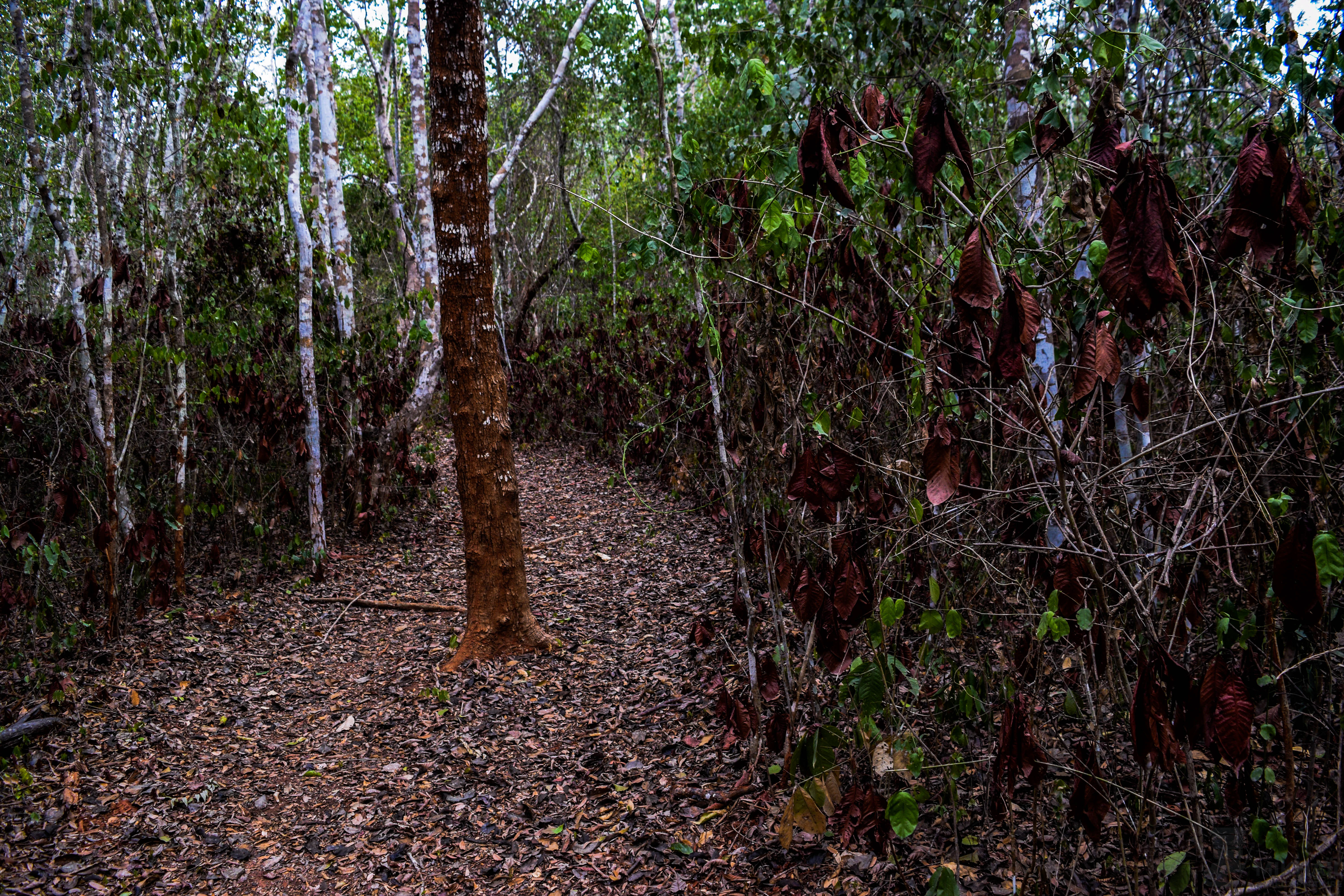
A dirt hiking path leading through a dense forest with trees and dry, brown foliage lining both sides.
A narrow walking path winding through the dense vegetation of the Forêt relique de Niaouli in Benin.

Forêt relique de Niaouli conservation status and protection priorities

Forêt relique de Niaouli is one of the small number of formally protected natural forest areas in southern Benin and one of the few surviving patches of dense semi-deciduous forest in the commune of Allada. Its protected status, established in 1997, acknowledges both its scientific value as a long-term research site and its ecological importance as a refuge for native flora and fauna in a region where natural forest cover has declined sharply over the past century.

The conservation significance of the site extends beyond Benin itself. Its location near the Dahomey Gap makes it a useful reference area for understanding how tropical forest species and communities respond to fragmentation and to the break between the moist forest zones of West and Central Africa. Studies of bats, birds, and plants at Niaouli have contributed to broader discussions on how species are distributed across this important biogeographic boundary. By preserving a mosaic of lowland riparian forest, plateau forest, and surrounding savanna edge in a compact area, the reserve protects not only individual species but also the ecological gradients that give the site its research and conservation value.

Forêt relique de Niaouli cultural meaning and human context

Niaouli does not have a strong documented indigenous or historical cultural identity of its own, but the surrounding landscape and the forest's plant community are deeply embedded in everyday local life. Several of the forest's most notable trees, including Antiaris toxicaria, Ceiba pentandra, Albizia zygia, and Newbouldia laevis, have been highlighted by ethnobotanical research as species with significant cultural, medicinal, or material value for nearby communities, with timber being the most commonly cited use.

The site is also entangled with the scientific and institutional history of Benin through the Niaouli agronomic research station, founded in 1904. The forest has effectively been shaped by more than a century of agricultural research activity, which both reduced its original extent but also happened to preserve a significant remaining block. This makes the site a meeting point between ecological, scientific, and rural cultural heritage, even though it is not associated with a specific ethnic group or community tradition beyond the broader rural population of the Allada commune.
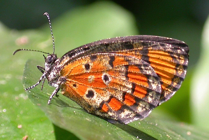
A close up view of a Mimeresia libentina butterfly with orange and black patterned wings, perched on a green leaf.
A Mimeresia libentina butterfly resting on a leaf in Forêt relique de Niaouli, Benin.

Top sights and standout views in Forêt relique de Niaouli

One of the most distinctive features of Niaouli is the coexistence, within a small protected area, of a waterlogged lowland forest on the banks of the Ava stream and a drier plateau forest bordered by savanna. This ecological contrast supports a richer combination of plant and animal species than the size of the reserve alone would suggest, with documented records of 223 plant species and 166 bird species.

Equally important is the forest's scientific role. Because it has been continuously studied since 1997, including for its position near the Dahomey Gap, Niaouli has become a reference site for understanding forest fragmentation, biogeographic patterns, and the conservation of West African forest wildlife. Its location inside one of Benin's oldest agricultural research stations also gives it a distinctive institutional history that complements its natural values.
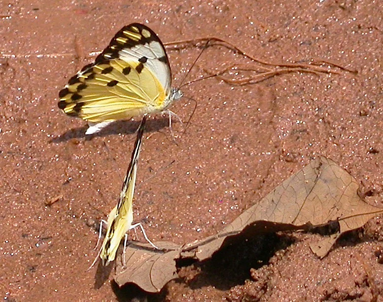
Two Belanois calypso butterflies shown mating while resting on reddish-brown soil next to a dried leaf.
A pair of Belanois calypso butterflies mating on the forest floor in Niaouli forest, Benin.

Best time to visit Forêt relique de Niaouli

Seasonal guidance for Niaouli is broad and limited by the sparse visitor-focused information in the source material. The southern Benin climate is typically characterized by a long rainy season and a drier season, and the lowland, waterlogged portion of the forest around the Ava stream is likely to be most striking during or shortly after the rains, when its flooded character is most visible. The drier plateau forest and surrounding savanna edge tend to be more accessible in the dry season, when ground conditions are firmer and walking through the area is easier. As Niaouli is primarily a research and conservation site rather than a mass tourism destination, visits are essentially tied to research activities or small guided naturalist excursions.
Monthly climate preview

Long-term representative point measurements of monthly temperature and precipitation rhythms

Forêt relique de Niaouli Climate Normals and Annual Temperature Patterns

Representative coordinate records show average monthly temperatures ranging from 24.65 to 28.14 degrees Celsius alongside varying daily precipitation rates across the year. Examining the full twelve-month dataset clarifies the detailed long-term climatic rhythm recorded for this protected area.
Annual mean27 °C
25 °C28 °C
Jan27°
Feb28°
Mar28°
Apr28°
May27°
Jun26°
Jul25°
Aug25°
Sep25°
Oct26°
Nov27°
Dec27°
Warmest month
February

28.1 °C

Coolest month
August

24.7 °C

Wettest month
June

6.1 mm/day

Driest month
January

0.5 mm/day

Park location guide

Geography guide, regional context, and park location map for Forêt relique de Niaouli

Forêt relique de Niaouli park geography, regions, and map view in Benin

Understand where Forêt relique de Niaouli sits in Benin through a broader geographic reading of the surrounding landscape, nearby location context, and its mapped position within the national park landscape.

How Forêt relique de Niaouli fits into Benin

Benin is a West African nation formerly known as Dahomey. It gained independence from France in 1960 and operates as a unitary presidential republic. The country is known for its coastal location along the Bight of Benin, its historical kingdom of Dahomey, and its agricultural economy centered on palm oil and cotton exports.

Wider geography shaping Forêt relique de Niaouli in Benin

Benin is located in West Africa, bordered by Togo to the west, Nigeria to the east, Burkina Faso to the northwest, and Niger to the northeast. The country occupies the southern coastline of the Bight of Benin, which is part of the Gulf of Guinea in the northernmost tropical portion of the Atlantic Ocean. The terrain ranges from coastal plains to hilly uplands in the north.

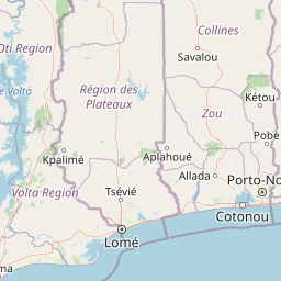
Map view of Forêt relique de Niaouli

Use this park location map to pinpoint Forêt relique de Niaouli in Benin, understand its exact geographic position, and read its mapped placement within the surrounding landscape more clearly.

Pigeon | © OpenStreetMap contributors

Location context for Forêt relique de Niaouli

Atlantique

Visual exploration of lowland forest habitats, plateau vegetation, and research station terrain in southern Benin

Forêt relique de Niaouli Photos, Scenery, and Protected Landscape Views

Visual records capture the dense semi-deciduous woodland, swampy riparian zones along the Ava stream, and dry plateau ecotones that define the reserve. Examining these protected habitats clarifies how the rare forest fragment maintains its ecological structure within an agricultural landscape.

A high angle view looking down into a dense, lush green forest featuring several tall, pale-barked Iroko trees rising above the thick understory foliage.

A close up view of a large tree with wide, triangular buttress roots extending into the forest floor, covered in dried leaves and surrounded by dense tropical vegetation.

A dense forest interior featuring tall, pale-barked canopy trees rising above thick green undergrowth and climbing vines.

A close-up view of an Azanus isis butterfly resting on damp, reddish-brown soil, showing its patterned cream and dark brown wings.

A dirt hiking path leading through a dense forest with trees and dry, brown foliage lining both sides.

Close up of a dark purple spadix flower standing above dry leaf litter in a forest.

A close up view of a Mimeresia libentina butterfly with orange and black patterned wings, perched on a green leaf.

Two Belanois calypso butterflies shown mating while resting on reddish-brown soil next to a dried leaf.

A close up view of an Acraea epaea butterfly with orange and black patterned wings resting on a smooth green leaf.

A close-up shot of a large brown and tan patterned snail shell lying among fallen leaves on the ground.

Park atlas

Compare regional forest reserves, lowland habitats, and connected conservation landscapes.

Explore Protected Areas and Parks Near Forêt relique de Niaouli in Southern Benin

Browse other parks near Forêt relique de Niaouli to examine similar tropical woodland fragments and regional protected areas. Comparing adjacent reserves provides deeper context on coastal forest ecology and fragmented wildlife habitats across southern Benin.
Protected areaOuémé
About 2.3 km away#1 closest

East

Basse vallée de l'Ouémé, lagune de Porto-Novo, lac Nokoué: Benin Wetland and Protected Area

Geographic analysis of a major West African riverine and lagoon system

Spanning the lower reaches of the Ouémé River, this protected wetland area in southern Benin integrates complex fluvial and coastal landscapes. The territory includes Lake Nokoué and the Porto-Novo lagoon, creating a vital hydrological basin that supports seasonal floodplains, mangrove fringes, and significant ecological connectivity. Examine the mapped boundaries and natural terrain of this unique West African environmental corridor.

Area
916 km²
Relief
Lowland
Climate
Tropical
Access
Access unknown
A watercolor painting showing a panoramic view of a river landscape with lush green trees, grasses, and soft pink foreground flowers against a light sky.
Nature reserveBenin
About 21 km away#2 closest

North

Forêt classée de la Lama: Nature Reserve Geography and Protected Area Landscape

A dense forest refuge located within the Dahomey Gap

The Forêt classée de la Lama is a significant nature reserve in Benin, characterized by its unique position in the Lama depression. This area preserves a crucial core of dense semi-deciduous forest surrounded by managed buffer zones. Examine the mapped terrain, hydrological features, and the distinct ecological role this reserve plays in West African forest conservation.

Area
162.5 km²
Established
1946
Relief
Lowland
Climate
Subtropical
Nature reserveAtlantique
About 27 km away#3 closest

Southeast

Vallée du Sitatunga: Nature Reserve Geography and Wetland Protected Area Context

Community-managed marshland ecosystems in southern Benin

Vallée du Sitatunga encompasses over 67,000 hectares of diverse terrain in southern Benin, ranging from humid forest to expansive floodplains. As a community-led nature reserve, it preserves a vital network of waterways and swamp habitats that sustain rare species such as the sitatunga. This landscape focus offers clear insight into the protected basin geography of the Atlantique region.

Area
700 km²
Established
2009
IUCN
VI
Relief
Lowland
A soft watercolor painting of a wetland scene with green trees and reeds in the foreground and rolling hills in the background.
Protected areaZou Department
About 37 km away#4 closest

North

Forêt marécageuse de Lokoli: Protected Alluvial Forest and Wetland Geography in Zou Department

A rare flooded ecosystem in southern Benin

Spanning approximately 500 hectares, Forêt marécageuse de Lokoli serves as a crucial refuge for primate species and native swamp-forest vegetation. The area illustrates a distinct alluvial geography, characterized by seasonal flooding from the Hlan stream that transforms the forest floor into a mosaic of shallow pools and dense, stilt-rooted woodland environments.

Area
5 km²
Relief
Lowland
Water
Major water bodies
Biosphere reserveBenin
About 51 km away#5 closest

Southeast

Réserve de biosphère de la Basse vallée de l’Ouémé: Geographic Overview and Protected Area Map

Coastal lagoon and river delta ecosystems in Benin

The Réserve de biosphère de la Basse vallée de l’Ouémé represents a significant protected landscape in southern Benin where riverine and marine influences converge. This biosphere reserve map highlights a dense network of mangroves, seasonally flooded grasslands, and freshwater lakes. Gain insights into the regional geography and hydrologic patterns of this important wetland complex.

Area
3,143.4 km²
Established
2020
Relief
Lowland
Climate
Tropical
A horizontal watercolor painting depicting a winding river flowing through a lush green landscape with distant hills under a light sky.
Biosphere reserveBenin
About 72 km away#6 closest

Southwest

Mono Transboundary Biosphere Reserve: Mapped Protected Landscapes and Regional Geography

Coastal river deltas, wetlands, and savanna transition zones

The Mono Transboundary Biosphere Reserve preserves a critical intersection of freshwater river systems and marine coastal environments. Stretching along the border of Benin and Togo, this protected area includes expansive mangroves, lagoons, and floodplains that transition into inland savanna. The geography of the reserve reflects a dynamic interface between land and water, encompassing a range of natural terrain that supports both ecological conservation and integrated regional land use.

Area
3,462.85 km²
Established
2017
Relief
Lowland
Climate
Tropical
A watercolor painting showing a soft, impressionistic landscape of Keta Lagoon, featuring patches of green vegetation, yellow grasses, and calm water against a light, airy background.
Protected areaVolta Region
About 172 km away#7 closest

Southwest

Keta Lagoon Protected Area: Coastal Wetland Geography and Regional Landscape Mapping

A vital ecological and cultural landscape in Ghana's Volta Region

Keta Lagoon represents a primary coastal wetland system in eastern Ghana. Spanning the coastline between sandy barriers and inland floodplains, this protected area features a unique mosaic of mangroves, tidal flats, and islands. Its role as a major waterbird habitat and the center of Anlo-Ewe cultural life makes it a significant site for understanding West African coastal geography and environmental conservation.

Area
1,200 km²
Established
1992
Relief
Lowland
Climate
Tropical
Wildlife reserveVolta Region
About 185 km away#8 closest

West

Kalakpa Game Production Reserve: Atlas Overview of Protected Terrain in Ghana

Ecological mosaic landscape in the Volta Region

Kalakpa Game Production Reserve represents a diverse protected area where Borassus and Combretum woodlands meet semi-deciduous gallery forests. Situated on the foothills of the Togo Mountains, this reserve provides essential habitat in the forest-savanna transition of southeastern Ghana, defined by its rugged rocky hills and seasonal valley streams.

Area
320 km²
Established
1975
IUCN
VI
Relief
Upland

Common questions about visiting, size, designation, and location context for Forêt relique de Niaouli

Forêt relique de Niaouli FAQs for park facts, access, geography, and protected area context

Find quick answers about Forêt relique de Niaouli, including protected-area facts, park geography, trail and visitor context, and how the park fits into its surrounding country and regional landscape.
MoriAtlas Explorer

Continue Your Protected Areas Search Across the Global Atlas

Deepen your exploration by continuing the structured search for national parks and protected areas worldwide. Utilize the comprehensive filtering capabilities to compare different conservation landscapes and refine your understanding of global park geography. Discover more about the distribution and characteristics of protected natural areas.

Global natural geography