
Mori Atlas logo
Protected areaFreudenthal bei Witzenhausen

A vital riverine wetland and bird habitat in northern Hesse within the Werra valley corridor.

Freudenthal bei Witzenhausen Protected Area and Werra Valley Regional Landscape Geography

(Naturschutzgebiet Freudenthal bei Witzenhausen)

Freudenthal bei Witzenhausen stands as a significant protected nature reserve located in the lower Werra valley of northern Hesse. This former gravel extraction site now encompasses a diverse mosaic of quarry lakes, reedbeds, and alluvial woodland that serve as a sanctuary for waterbirds and diverse dragonfly populations. The area is integral to the broader Auenverbund Werra landscape and functions as a recognized biodiversity hotspot in central Germany.

former gravel pitquarry lakeswetland reservealluvial woodlandriverine floodplainwaterbird sanctuary
A flat-design illustration featuring a calm body of water reflecting a large hill covered in evergreen trees, with foreground vegetation including fallen branches and reeds.

Freudenthal bei Witzenhausen

Protected area

Park overview

Structured park overview, official facts, and landscape profile for Freudenthal bei Witzenhausen

Freudenthal bei Witzenhausen park facts, protected area profile, and essential visitor context

Review the core facts for Freudenthal bei Witzenhausen, including designation, size, terrain, visitor scale, habitats, and operating context in one park-focused overview.

About Freudenthal bei Witzenhausen

Freudenthal bei Witzenhausen is a compact but ecologically rich protected area in the lower Werra valley, in the northern part of the German state of Hesse. The reserve occupies a sheltered basin in the floodplain of the Werra river, near the town of Witzenhausen and the village of Ermschwerd, and forms part of the larger Werra-Meißner landscape of rolling hills, river meadows, and forest uplands.

At the core of the protected area are three former gravel-extraction lakes, with a combined water surface of roughly twenty-one hectares. These pit lakes, together with their steep gravel banks, reed fringes, floating vegetation, and slowly developing alluvial woodland, form the heart of the reserve. Surrounding the lakes are extensive areas of intensively used farmland, meadows along the Werra, hedges, and traditional orchards, which together create a varied mosaic of open and sheltered habitats.

The reserve has formally three layers of protection: a German Naturschutzgebiet designation since 1980, integration into the European Natura 2000 network as a Flora-Fauna-Habitat site since 2004, and complete inclusion in the Auenverbund Werra landscape protection area since 1992. The Werra valley, together with the Hoher Meißner and the Kaufunger Wald, is recognized as a national biodiversity hotspot, and Freudenthal is one of its key riverine components.

For visitors and conservationists alike, Freudenthal demonstrates how a former industrial site, once primarily shaped by gravel mining and intensive agriculture, can be transitioned into a functioning refuge for breeding, migrating, and wintering waterbirds, as well as for dragonflies, butterflies, and amphibians. It is a small but instructive example of how Natura 2000 sites can be embedded within working agricultural landscapes.

Quick facts and research context for Freudenthal bei Witzenhausen

Freudenthal bei Witzenhausen is a 76-hectare nature reserve and Natura 2000 Flora-Fauna-Habitat site in the lower Werra valley in northern Hesse, near the town of Witzenhausen and the village of Ermschwerd. The area sits at about 135 meters above sea level in a sheltered basin location of the Werra valley, surrounded by agricultural land and bounded to the north by the Bundesstraße 80.

The reserve was established as a Naturschutzgebiet in 1980 and integrated into the Natura 2000 network as an FFH area in the early 2000s. It overlaps completely with the Auenverbund Werra landscape protection area designated in 1992. Its defining feature is a cluster of former gravel-extraction lakes, combined with alluvial woodland, reedbeds, meadows, and open farmland, supporting a notably rich bird, dragonfly, and butterfly fauna.

Protection and recognition

Examine the terrestrial conservation framework and official protected area records.

Freudenthal bei Witzenhausen Protection Status and Natura 2000 Recognition

Records detail the terrestrial protection status and Natura 2000 recognition for Freudenthal bei Witzenhausen. Data points outline the documented management scope and official designation sources for this landscape.

International recognition

Protection details

Protection scope
Terrestrial
Transboundary protection
No
WDPA ID
81693
Park context

Deeper park guide and search-rich context for Freudenthal bei Witzenhausen

Freudenthal bei Witzenhausen history, landscape, wildlife, and travel context

Explore Freudenthal bei Witzenhausen through its history, landscape character, ecosystems, wildlife, conservation priorities, cultural context, and seasonal travel timing in a structured park guide built for atlas discovery and search intent.

Why Freudenthal bei Witzenhausen stands out

Freudenthal is best known as one of the most important man-made wetland bird sanctuaries in northern Hesse. The former gravel pits around Witzenhausen have been transformed into a network of quarry lakes, reed-fringed shorelines, and adjacent meadows that together provide breeding, resting, and wintering habitat for numerous waterbirds, including several threatened species listed under Annex I of the EU Birds Directive. The reserve is also notable for the unusually high density of dragonflies recorded at its pit lakes, which qualify as a regionally to statewide significant dragonfly habitat. Together, these qualities make Freudenthal a textbook example of how a post-industrial extraction landscape can be converted into a high-value conservation area within the broader Werra valley biodiversity hotspot.
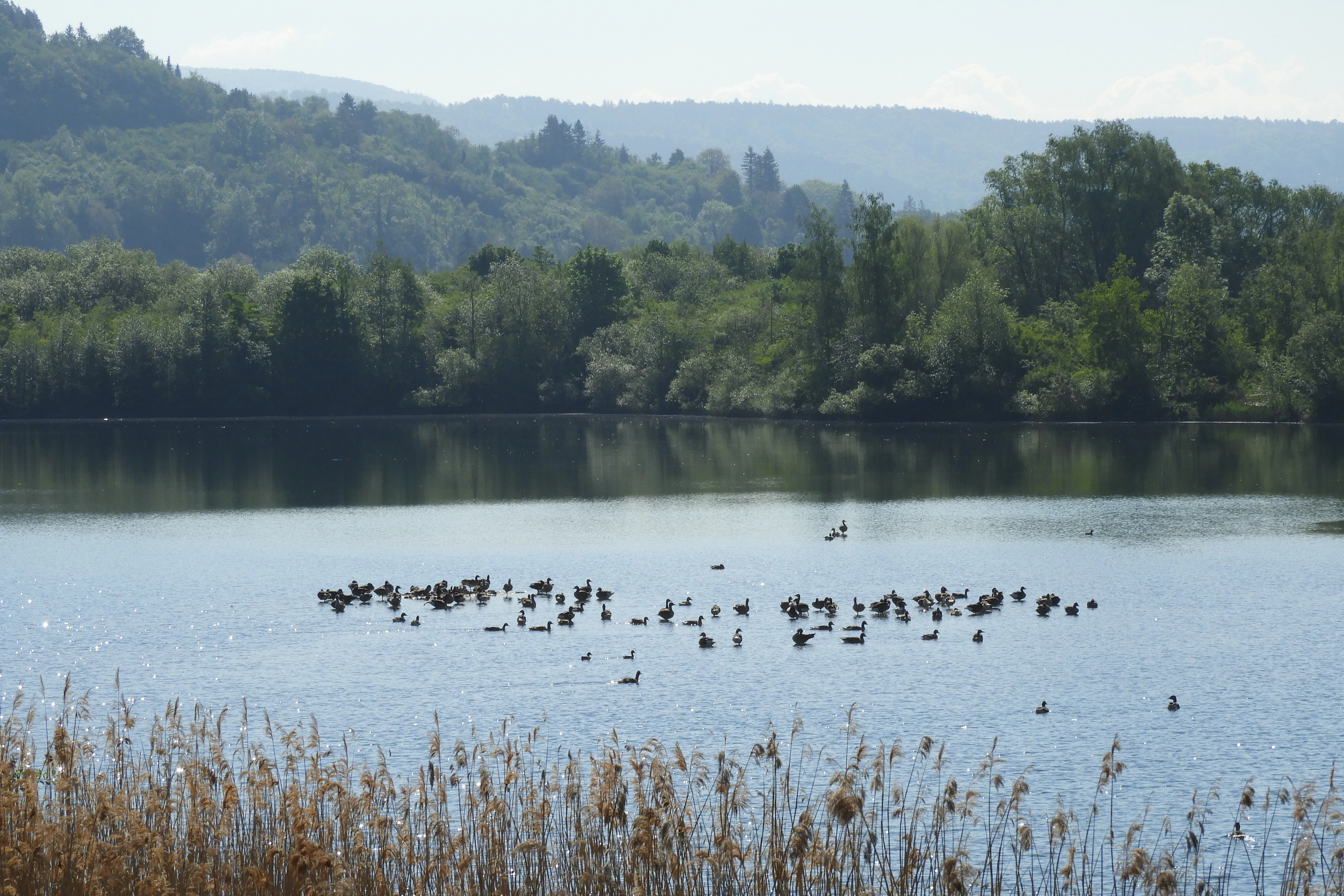
A wide shot of a lake filled with a flock of small birds, surrounded by trees and reeds.
A flock of birds swimming on one of the lakes in the Freudenthal nature reserve.

Freudenthal bei Witzenhausen history and protected-area timeline

The area now known as Freudenthal began its modern history as an agricultural landscape in the middle Werra valley, with meadows dominating the river-near zones. From the mid-1950s onward, the local gravel and sand deposits were recognized as valuable raw materials, and a quarrying operation was established on what is today the lake area. Gravel extraction continued for several decades, transforming the original floodplain into a mosaic of pit lakes, spoil heaps, and operating infrastructure.

Industrial extraction was gradually reduced and finally stopped in the mid-1990s. Recognizing the emerging ecological value of the abandoned pits, the regional forestry and nature conservation authority in Kassel issued a protection order on 19 September 1980, designating the area as the Naturschutzgebiet Freudenthal. The original designation covered roughly 72 hectares and was later expanded by an additional ordinance within the same year to include farmland in the Gemarkungen of Ermschwerd and Witzenhausen, bringing the reserve to its present size of about 76 hectares.

In 1992, the broader Auenverbund Werra landscape protection area was established, and Freudenthal was placed entirely within its boundaries, providing an additional layer of protection for the Werra meadows and floodplain ecosystems. The reserve was reported to the European Commission in 2004 as a candidate Flora-Fauna-Habitat site under the EU Habitats Directive. A formal protection order for Natura 2000 areas in Hesse followed in January 2008, giving the site its current legal foundation as FFH-Gebiet 4624-303.

Since designation, the eastern lakes and ruderal zones have been kept free of active use, allowing natural succession around the water bodies. The western lake continues to allow limited angling on roughly one-third of its area, while the meadows along the Werra and around the lake margins are managed extensively. Today, Freudenthal is recognized as one of the most bird-rich former gravel pits in northern Hesse and as an important reference site for post-industrial wetland restoration in the Werra valley.

Freudenthal bei Witzenhausen landscape and geographic character

Freudenthal lies in a sheltered basin of the lower Werra valley, at an elevation of roughly 135 meters above sea level. The surrounding uplands shield the basin and give it a comparatively mild local climate, a classic setting for riverine habitat development. The reserve itself occupies former alluvial deposits laid down by the Werra since the end of the last ice age, where layers of gravel, sand, and organic material have produced brown floodplain soils, or Vega soils, beneath the modern landscape.

The most striking physical feature of the reserve is the trio of pit lakes created by decades of gravel mining. These lakes are surrounded by the steep, exposed banks typical of quarry sites, with only narrow zones of shallow water and reed stands. Around the water bodies, the landscape gradually softens into alluvial woodland, ruderal vegetation, meadows, and hedges, before meeting the larger open arable fields to the north and northwest, where intensive agriculture continues today.

To the south, the Freudenthal area reaches the wide outer meander of the Werra, whose floodplain meadows form an important buffer to the reserve. To the east and west, the protected area borders additional farmland, while the Bundesstraße 80 provides a clear northern boundary. The natural regional classification places the site within the Witzenhausen-Hedemündener Werratal subunit of the Unteres Werrabergland, at the transition between the Osthessisches Bergland uplands to the north and the Kaufunger Wald forest area to the south.
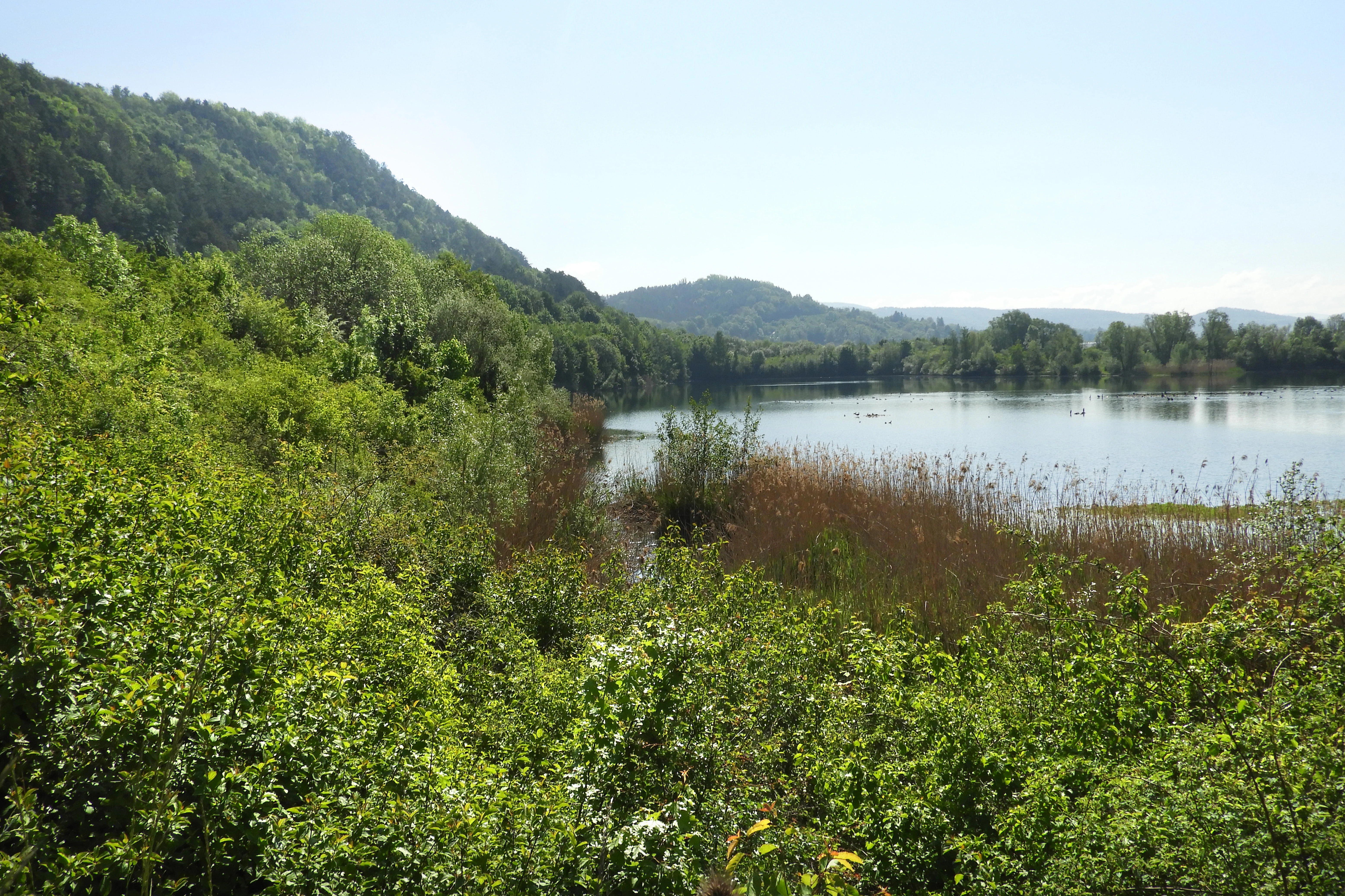
A peaceful lake surrounded by lush green shrubs and trees, with rolling forested hills in the distance under a clear sky.
A scenic view of a gravel lake at the Freudenthal nature reserve in the Werra valley.

Freudenthal bei Witzenhausen ecosystems, habitats, and plant life

The ecological character of Freudenthal is defined by the close interplay of standing water, wetland margins, alluvial woodland, and adjacent open farmland. Within the formal Natura 2000 framework, three key habitat types of community interest have been identified and protected. These include nutrient-poor to moderately nutrient-rich calcareous standing waters with charophyte algae, nutrient-rich standing waters with pondweed or frogbit communities, and alluvial forests of alder, ash, and softwood gallery types.

The smallest, central lake falls into the first category and is characterized by relatively low species diversity, with a documented presence of charophyte algae. The two larger lakes belong to the second category and feature the steep banks and pioneer vegetation typical of former gravel pits. Where shallow water zones have developed, common reed has expanded, in some cases assisted by planting, and now serves as both shelter and nesting habitat for waterbirds. Common aquatic plants include rigid hornwort, fennel pondweed, and three-lobed duckweed, with yellow water-lily and water knotweed occurring in patches.

Along the lake margins, an alluvial woodland belt has formed, with older stands of willow, ash, and sycamore maple in some sections and pioneer woodland stages elsewhere. These wooded fringes connect the open water to surrounding meadows and croplands and provide important structural diversity across the reserve. Ruderal vegetation on former mining surfaces adds a further open-ground component, supporting invertebrates and seed-eating birds. Together, these habitats create an unexpectedly rich ecological mosaic for a site of only seventy-six hectares.
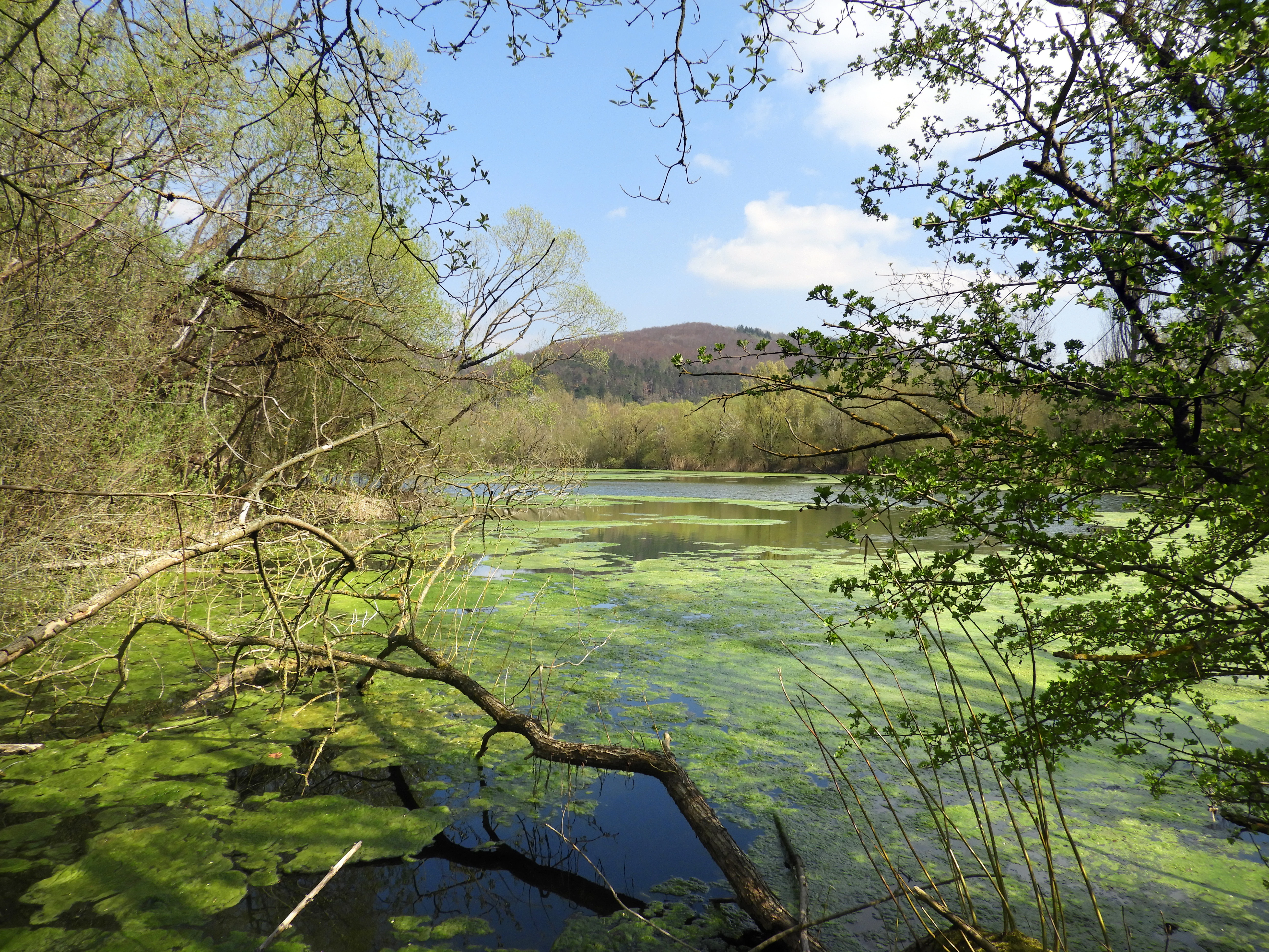
A peaceful pond covered in green algae surrounded by trees and shrubs, with a distant hill visible under a blue sky.
A view of the wetland habitat at Freudenthal Nature Reserve, featuring lush vegetation and a quiet pond.

Freudenthal bei Witzenhausen wildlife and species highlights

Freudenthal is primarily a bird-oriented reserve, and its ornithological importance is the core of its conservation identity. The combination of open water, reedbeds, alluvial woodland, meadows, hedgerows, orchards, and surrounding cropland supports more than twenty Red List bird species, including five species listed in Annex I of the EU Birds Directive because of small populations, restricted ranges, or specialized habitat needs.

Breeding birds at the site include the northern lapwing, wryneck, little ringed plover, common sandpiper, common snipe, and whinchat, all of which are considered threatened with extinction in Hesse. The marsh harrier, reed warbler, orphean warbler, and penduline tit are recorded as breeding species on the regional watch list, with declining populations reflecting wider trends. Once-common farmland species such as the skylark, grasshopper warbler, and tree sparrow have also shown marked declines locally. Red-backed shrike breeds within the reserve, and the common kingfisher breeds on the steep banks of the Werra itself, while grey woodpecker, black kite, and red kite typically nest in surrounding woodlands and use the reserve as hunting territory.

Among the visitors, fish eagle, common teal, garganey, northern shoveler, and common pochard are recorded as spring and autumn passage and stopover species. The site functions as a stepping-stone biotope, broadening its ecological significance well beyond the local area. Beyond birds, Freudenthal stands out for its insect fauna. More than thirty butterfly and burnet moth species have been documented, including notable species such as the large fritillary, brown hairstreak, large grizzled skipper, swallowtail, white-banded meadow brown, small rock-rose blue, small pearl-bordered fritillary, scarce copper, silver-washed fritillary, and several burnet moths. The dragonfly fauna is regionally significant, with twenty-one species recorded in a single survey season, including the small kingfisher dragonfly and small bluetail as strongly endangered species, alongside other threatened and watch-list species. Four amphibian species, including the lake frog and common toad, complete the vertebrate picture, with relatively strong local populations for the threatened lake frog.

Freudenthal bei Witzenhausen conservation status and protection priorities

Freudenthal's conservation value rests on its layered protection regime and its role within both national and European biodiversity frameworks. The site was the first step, established as a Naturschutzgebiet in 1980 with the explicit aim of protecting its ornithologically valuable water bodies, maintaining and improving their function as breeding, passage, and wintering habitat for waterbirds, and securing the necessary foraging and nesting resources while minimizing disturbance.

At the European level, the reserve was identified in 2004 as a candidate Natura 2000 Flora-Fauna-Habitat site and received its formal protection order in January 2008. Under the Habitats Directive, the site's conservation objectives include maintaining the biotope-defining water quality and characteristic vegetation of the lakes, and preserving near-natural, structurally rich alluvial woodland stands. The reserve's boundaries are identical to those of the FFH area, providing a coherent single management unit.

At the landscape scale, Freudenthal lies within the Auenverbund Werra landscape protection area, established in 1992. This broader designation protects the river's meadows, banks, and near-natural stretches across the Werra-Meißner-Kreis and Landkreis Hersfeld-Rotenburg, and has led to the Werra valley, together with the Hoher Meißner and the Kaufunger Wald, being recognized as a national biodiversity hotspot. Within this larger context, Freudenthal is a critical floodplain node: a relatively small site that, thanks to its combination of gravel-pit lakes, alluvial forest, and traditional farmland, anchors much of the riverine bird and invertebrate biodiversity of the lower Werra valley.

Freudenthal bei Witzenhausen cultural meaning and human context

Freudenthal is embedded in a working agricultural landscape of northern Hesse, where intensive farming and traditional land use coexist with nature conservation. The reserve's southern edge reaches the outer meander of the Werra, and the meadows along the river and around the lake margins are managed extensively, preserving the historical riverside grassland tradition of the region. Hedges, orchards, and small-scale meadows around the site reflect centuries of mixed agricultural use in the Werra valley.

The reserve is also part of the Geo-Naturpark Frau-Holle-Land, a regional geopark that links the area's natural history, cultural heritage, and landscape identity. The name Freudenthal itself, meaning roughly "valley of joy," is shared with a small settlement in the Gemarkung of Ermschwerd, and illustrates how rural place names continue to mark the cultural geography of the Werra valley. While Freudenthal is primarily a nature conservation site rather than a cultural heritage site, its setting in a long-inhabited riverine landscape gives its protected habitats an additional dimension of regional identity.

Top sights and standout views in Freudenthal bei Witzenhausen

The standout features of Freudenthal are its three quarry lakes with their steep gravel banks and developing reed fringes, combined with alluvial woodland and surrounding farmland that together host a remarkable concentration of rare breeding, passage, and wintering waterbirds.

Equally distinctive is the site's insect fauna, particularly its dragonfly community, which places Freudenthal among the regionally to statewide important dragonfly habitats, and its rich butterfly and burnet moth assemblage. Layered protection as a Naturschutzgebiet, Natura 2000 FFH area, and part of the Auenverbund Werra landscape protection area gives the reserve a robust and durable conservation profile, while its position in the Werra valley biodiversity hotspot links it to one of Germany's most important riverine conservation landscapes.

Best time to visit Freudenthal bei Witzenhausen

Freudenthal's ecological character shifts notably with the seasons, which is reflected in the patterns of its bird life. Spring and early summer are the most rewarding periods for observing breeding waterbirds, lapwings, plovers, and passerines of open habitats such as whinchat and wryneck, when meadows and reedbeds are at their most active.

Late summer and early autumn bring the peak of dragonfly activity around the pit lakes, when males defend territories along the reed margins and the larger dragonfly species are easiest to observe. Autumn is also a key time for migratory waterfowl stopover, with species such as teal, garganey, shoveler, and pochard using the lakes as resting habitat. Winter can offer concentrations of waterbirds on the ice-free portions of the lakes, depending on ice cover and weather. The reserve can be walked relatively easily throughout the year using existing farm and service tracks, and the surrounding agricultural landscape opens up broad views of the lower Werra valley.

Monthly climate preview

Long-term monthly temperature averages and precipitation patterns for Hesse

Freudenthal bei Witzenhausen Climate Normals and Annual Temperature Rhythm

Representative coordinate records show average monthly temperatures ranging from sub-zero winter lows to warm summer maximums alongside consistent daily precipitation rates. Examining the full twelve-month profile reveals the complete climatological rhythm measured across the protected landscape.
Annual mean8 °C
-1 °C18 °C
Jan-1°
Feb
Mar
Apr
May12°
Jun16°
Jul18°
Aug18°
Sep14°
Oct
Nov
Dec
Warmest month
July

18.2 °C

Coolest month
January

-0.9 °C

Wettest month
July

2.6 mm/day

Driest month
April

1.5 mm/day

Park location guide

Geography guide, regional context, and park location map for Freudenthal bei Witzenhausen

Freudenthal bei Witzenhausen park geography, regions, and map view in Germany

Understand where Freudenthal bei Witzenhausen sits in Germany through a broader geographic reading of the surrounding landscape, nearby location context, and its mapped position within the national park landscape.

How Freudenthal bei Witzenhausen fits into Germany

Germany is a federal republic in Western and Central Europe with a population of over 83 million across sixteen constituent states. It is Europe's largest economy by nominal GDP and a major global exporter and importer. The capital is Berlin, and the country borders Denmark, Poland, Czech Republic, Austria, Switzerland, France, Luxembourg, Belgium, and the Netherlands.

Wider geography shaping Freudenthal bei Witzenhausen in Germany

Germany is located in Western and Central Europe, spanning 357,022 km². It borders Denmark to the north, Poland and the Czech Republic to the east, Austria and Switzerland to the south, and France, Luxembourg, Belgium, and the Netherlands to the west. The country has coastlines on the Baltic Sea and North Sea to the north, with the Alps located in the southern region.

Map view of Freudenthal bei Witzenhausen

Use this park location map to pinpoint Freudenthal bei Witzenhausen in Germany, understand its exact geographic position, and read its mapped placement within the surrounding landscape more clearly.

Pigeon | © OpenStreetMap contributors

Location context for Freudenthal bei Witzenhausen

Hesse
Recorded earthquake history

View the Recorded Earthquake History for Freudenthal bei Witzenhausen

MoriAtlas provides a structured record of seismic events associated by location with Freudenthal bei Witzenhausen. Examine specific data entries including magnitude and epicentre distance to better understand the regional seismic context of this northern Hesse nature reserve.

Freudenthal bei Witzenhausen Earthquake History

Catalogued events

2 events

Strongest magnitude

Magnitude 3.1

Most recent event

Mar 30, 1995

This history includes earthquakes recorded inside the park or within 50 km of its borders

Visualizing the quarry lakes, riverine habitats, and protected wetlands of northern Hesse

Freudenthal bei Witzenhausen Photos and Landscape Imagery

Visual records document the distinct topography, quarry lakes, and alluvial woodland environments that define the Freudenthal bei Witzenhausen protected area. Examining these environmental photographs helps researchers and visitors analyze the ecological character and terrain features of the lower Werra valley landscape.

A wide shot of a lake filled with a flock of small birds, surrounded by trees and reeds.

A calm lake reflects lush green trees and a clear blue sky, with the steeple of a distant village church visible in the background.

A peaceful lake surrounded by lush green shrubs and trees, with rolling forested hills in the distance under a clear sky.

A peaceful pond covered in green algae surrounded by trees and shrubs, with a distant hill visible under a blue sky.

Park atlas

Compare adjacent protected areas and river valley habitats across northern Hesse

Parks Near Freudenthal bei Witzenhausen and Surrounding Regional Reserves

Browsing parks near Freudenthal bei Witzenhausen reveals broader wetland reserves and riverine protected landscapes throughout the lower Werra valley basin. Evaluating these adjacent conservation areas provides valuable geographic context for understanding regional biodiversity networks and post-industrial habitats.
A minimalist watercolor painting featuring soft green trees and rolling hills in the background against a light, airy white backdrop.
Nature reserveWerra-Meißner-Kreis
0.5 km away#1 closest

West

Ermschwerder Heegen Nature Reserve: Muschelkalk Ridge and Floodplain Geography

Protected mosaic of forests, marshes, and meadows in northern Hesse

Ermschwerder Heegen preserves a compact but ecologically significant landscape in the Werra-Meißner-Kreis. Its unique topography features a limestone ridge dropping into the Werra valley, supporting a rich mixture of forest, orchard, and wetland habitats that rank among the most important in the region for biodiversity.

Area
0.37 km²
Established
1985
IUCN
IV
A horizontal watercolor illustration depicting rolling green hills, scattered trees, and soft mountain silhouettes against a pale sky.
Protected areaGermany
2.9 km away#2 closest

South

Kalkmagerrasen bei Roßbach: Protected Calcareous Grassland and Juniper Landscape in Germany

Geographic atlas and protected area overview in Hesse

Kalkmagerrasen bei Roßbach consists of five distinct plots that protect rare Enzian Schillergras Rasen communities on shallow Zechstein limestone soils. This site remains a critical stronghold for diverse orchid populations and protected butterfly species within the Werra Meißner region. The mosaic of juniper, flowering herbs, and historic cherry orchards creates a unique Mediterranean character rarely found in central German hill country.

Area
0.551 km²
Established
1996
Relief
Upland
Climate
Temperate
Protected areaEllerode
4.4 km away#3 closest

North

Kreideberg bei Ellerode Protected Area: Geography, Boundaries, and Landscape Map

A diverse calcareous forest habitat in northern Hesse

The Kreideberg bei Ellerode reserve showcases a unique geological character with its chalk-influenced substrate and rich botanical communities. This protected landscape encompasses old-growth beech stands, semi-dry grasslands, and rare calcareous spring features. The site represents an essential, compact habitat corridor within the broader Werra-Meißner-Kreis regional geography.

Area
0.571 km²
Established
1995
Relief
Upland
Climate
Temperate
Watercolor painting of a pastoral landscape with light green hills in the distance, a field with flowering pink trees, and a pale green meadow in the foreground.
Nature reserveWerra-Meißner-Kreis
5 km away#4 closest

Southeast

Ebenhöhe-Liebenberg Nature Reserve: Geography and Protected Habitat Mapping

Protected calcareous forests and dry grassland mosaic

Explore the mapped boundaries and natural terrain of the Ebenhöhe-Liebenberg nature reserve. This site provides a critical habitat mosaic including orchid-rich beech woodlands, nutrient-poor grasslands, and sandstone outcrops that form a significant conservation area within the Hessian highlands.

Area
142.48 km²
Established
1995
IUCN
IV
Relief
Upland
A soft watercolor illustration depicting a winding river landscape with lush trees and rolling hills in the background.
Nature reserveLandkreis Eichsfeld
About 9.2 km away#5 closest

Southeast

Kelle, Teufelskanzel Nature Reserve: Geographic Overview and Protected Area Atlas

Steep slopes and sandstone ridges in Landkreis Eichsfeld

Situated along the Höheberg ridge in Thuringia, Kelle, Teufelskanzel represents a vital 200 hectare nature reserve. Its geography is defined by deep V-shaped valleys, dramatic rock outcrops like the Teufelskanzel, and a dense mix of deciduous forests that form part of the historic Inner German Border conservation zone.

Area
2.002 km²
Established
1996
IUCN
IV
Relief
Mountain
Watercolor painting of a mountain landscape with green slopes, coniferous forests, and rocky outcroppings under a soft, light-filled sky.
Nature reserveHesse
9.7 km away#6 closest

South

Meißner Nature Reserve in Northern Hesse: Mapping the Hoher Meißner Basaltic Massif

A comprehensive look at forest wilderness, bogs, and volcanic geology

Covering roughly 930 hectares, the Meißner nature reserve in northern Hesse protects an ecologically distinct upland landscape. The area features a significant basalt plateau, ancient scree slopes, mountain meadows, and hanging spring bogs, offering a prime example of protected central German topography and forest wilderness.

Area
9.322 km²
Established
1989
IUCN
IV
Relief
Mountain
A horizontal watercolor illustration depicting gentle rolling hills, grassy meadows, and distant mountain silhouettes in muted pastel tones.
Nature reserveThuringia
11 km away#7 closest

East

Röhrsberg - Hasenwinkel - Mühlberg: Mapping the Protected Landscapes of Thuringia

Geological ridge systems and native forest habitat networks.

The Röhrsberg - Hasenwinkel - Mühlberg nature reserve represents a significant protected area in Thuringia, characterized by the juxtaposition of Muschelkalk limestone hills and Zechstein dolomite ridges. This site offers a concentrated view of regional terrain, shifting from closed beech forests to open juniper heaths. It serves as an essential geographic reference for understanding the ecological mosaic of the lower Werra hill country.

Area
4.51 km²
Established
1999
IUCN
IV
Relief
Upland
A horizontal watercolor painting depicting a soft, atmospheric landscape with rolling green hills, a winding river or water feature, and distant pale mountains under a hazy, pastel sky.
Protected landscapeLower Saxony
About 11 km away#8 closest

West

Naturpark Münden Protected Landscape: Geography and Regional Mapping in Lower Saxony

Forested ridges and river valleys in southern Germany

Naturpark Münden offers a detailed look at the central German low mountain range. Discover the mapping of the Kaufunger Wald and Bramwald, the significance of the Fulda and Werra river confluences, and the structure of this historically significant protected landscape located in Lower Saxony.

Area
374 km²
Established
1959
Relief
Mountain
Water
Major water bodies

Common questions about visiting, size, designation, and location context for Freudenthal bei Witzenhausen

Freudenthal bei Witzenhausen FAQs for park facts, access, geography, and protected area context

Find quick answers about Freudenthal bei Witzenhausen, including protected-area facts, park geography, trail and visitor context, and how the park fits into its surrounding country and regional landscape.
MoriAtlas Explorer

Continue Your Protected Areas Search Across the Global Atlas

Deepen your exploration by continuing the structured search for national parks and protected areas worldwide. Utilize the comprehensive filtering capabilities to compare different conservation landscapes and refine your understanding of global park geography. Discover more about the distribution and characteristics of protected natural areas.

Global natural geography