Mori Atlas logo
Nature reserveGimmlitztal

Examining the ecological landscape, stream-side meadows, and forest terrain of this Saxon nature reserve.

Gimmlitztal Nature Reserve: A Protected Stream Valley Corridor in the Eastern Ore Mountains

(Naturschutzgebiet Gimmlitztal)

Gimmlitztal serves as a vital protected area within the German state of Saxony, encompassing the diverse stream valley of the Gimmlitz river in the eastern Ore Mountains. This reserve preserves a complex mosaic of moist ravine forests, wet meadows, and riverine habitats that demonstrate the transition between lowland valleys and elevated mountain ridges. By integrating historical land use patterns with modern conservation, the area maintains a distinct topographic and biological corridor within the Osterzgebirge region.

Ore MountainsSaxonyriver valleystream corridorwet meadowsmixed forest

Gimmlitztal

Nature reserve

Park overview

Structured park overview, official facts, and landscape profile for Gimmlitztal Nature Reserve

Gimmlitztal Nature Reserve park facts, protected area profile, and essential visitor context

Review the core facts for Gimmlitztal Nature Reserve, including designation, size, terrain, visitor scale, habitats, and operating context in one park-focused overview.

About Gimmlitztal Nature Reserve

Gimmlitztal Nature Reserve occupies a central position in the eastern Ore Mountains of Saxony, anchoring a stretch of the Gimmlitz valley that runs west, southwest, south, and southeast around the town of Frauenstein. The protected territory covers approximately 258 hectares, crossing the administrative boundary between Landkreis Mittelsachsen and Landkreis Sächsische Schweiz-Osterzgebirge. This cross-district situation gives the reserve a regional significance that extends beyond typical single-municipality conservation projects.

The valley landscape itself is defined by the Gimmlitz stream and its small tributaries, which have carved modest but ecologically important corridors through the uplifted terrain of the Ore Mountains. The slopes around the stream support mixed deciduous and coniferous forest stands typical of the middle elevations of the Erzgebirge. Lower and flatter sections of the valley floor contain wet meadow patches, brookside thickets, and small wetland zones that contribute substantially to the area's overall biodiversity. These valley meadows are remnants of traditional hay use that historically shaped the appearance of Ore Mountain river valleys.

Although the region has experienced long-term human influence through mining, quarrying, forestry, and farming, the protected area focuses on preserving the remaining mosaic of natural and semi-natural habitats. In the northwest, the Lichtenberg reservoir area lies adjacent to the reserve, while the federal road B 171 crosses the valley, illustrating the balance the reserve must maintain between ecological integrity and the existing infrastructural footprint. Toward the south, the protected area continues into the direction of the Czech national border, supporting transboundary ecological connectivity within the broader Ore Mountains.

The reserve connects meaningfully with the earlier Gimmlitzwiesen site, a smaller meadow area southwest of Hermsdorf in the Erzgebirge that was placed under protection in 1974. Through the 2015 designation of the larger Gimmlitztal area, conservation management could finally treat these earlier patches as integral parts of a wider valley-scale ecosystem. This integration strengthens both habitat continuity and the long-term viability of meadow and riparian species that depend on connected landscape structures.

Quick facts and research context for Gimmlitztal Nature Reserve

Gimmlitztal is a Saxony nature reserve (Naturschutzgebiet) with the official designation C 102, classified under IUCN Category IV as a habitat and species management area. It lies in the Ore Mountains, spanning the districts of Mittelsachsen and Sächsische Schweiz-Osterzgebirge, and was placed under formal protection in 2015.

The reserve extends around the town of Frauenstein along the Gimmlitz stream and reaches toward the Czech border in the south. Its territory intersects with the protected area boundaries of the earlier Gimmlitzwiesen reserve near Hermsdorf and overlaps with regional infrastructure corridors, including the Lichtenberg reservoir area in the northwest and the federal road B 171 that crosses through the valley.

Protection and recognition

Documented conservation status and international recognition records for Gimmlitztal

Gimmlitztal Protection Status and Natura 2000 Recognition Data

Gimmlitztal holds official protection records including designated Natura 2000 framing for environmental conservation. Official recognition sources outline the documented administrative status and formal designation history for the protected area.
Park context

Deeper park guide and search-rich context for Gimmlitztal Nature Reserve

Gimmlitztal Nature Reserve history, landscape, wildlife, and travel context

Explore Gimmlitztal Nature Reserve through its history, landscape character, ecosystems, wildlife, conservation priorities, cultural context, and seasonal travel timing in a structured park guide built for atlas discovery and search intent.

Why Gimmlitztal Nature Reserve stands out

Gimmlitztal is best known for protecting the valley landscape of the Gimmlitz stream, including the characteristic mosaic of moist ravine forests, wet meadows, and stream-side habitats typical of the eastern Ore Mountains. It incorporates and expands upon the older Gimmlitzwiesen meadow reserve, linking small protected patches into a larger, ecologically continuous corridor. The landscape also reflects a long history of human use, including the Hermsdorf limestone quarrying works and traditional agricultural use of valley meadows. The reserve therefore stands out as a place where natural stream dynamics, species-rich meadows, and culturally shaped mountain scenery meet within a single protected unit.
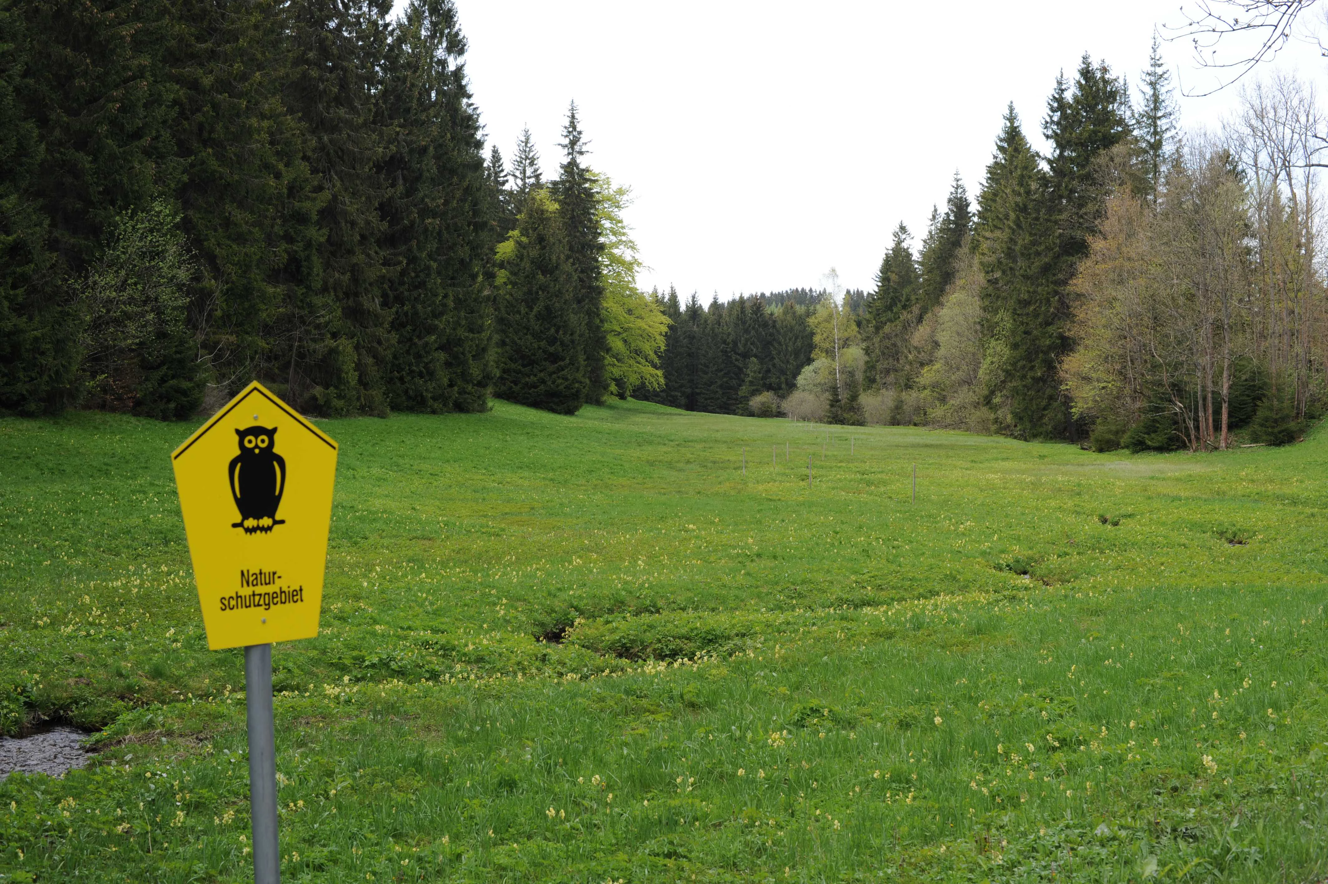
A yellow pentagonal nature reserve sign featuring a black owl silhouette stands in the foreground of a grassy valley with coniferous trees in the background.
A nature reserve sign marks the lush green meadow in the Gimmlitztal valley.

Gimmlitztal Nature Reserve history and protected-area timeline

The protected status of Gimmlitztal has a layered history rooted in the conservation traditions of Saxony. In 1974, a small site known as the Gimmlitzwiesen, covering roughly 1.58 hectares southwest of Hermsdorf in the Erzgebirge, became one of the earliest formally protected grassland areas within the broader Gimmlitz valley. This modest designation reflected the long-standing recognition of wet meadow habitats along the Gimmlitz as worthy of conservation attention.

Decades later, in 2015, the modern Gimmlitztal nature reserve was formally established under the designation C 102, encompassing a substantially larger area of about 258 hectares. This expanded protection aimed to integrate the original Gimmlitzwiesen into a broader valley-level conservation framework, ensuring that the ecological and hydrological relationships of the Gimmlitz stream and its surrounding forests, meadows, and slopes could be managed as a coherent whole rather than as isolated small sites.

The reserve's history reflects broader trends in Saxon nature conservation policy, which have increasingly emphasized the consolidation of fragmented protected sites into larger, ecologically meaningful landscape units. This approach allows management strategies addressing forest dynamics, watercourse health, and traditional meadow maintenance to operate across larger scales than older site-by-site protection permitted.

Gimmlitztal Nature Reserve landscape and geographic character

The landscape of Gimmlitztal is shaped by the gentle to moderately steep slopes of a typical Ore Mountain river valley, with the Gimmlitz stream forming the central topographical axis. The valley runs broadly east-to-west and northwest-to-southeast through the protected area, producing a varied topography of moist valley floors, broad meander sections, and ascending forested slopes.

Elevations across the reserve remain within the middle range of the eastern Erzgebirge, and the terrain alternates between narrow, sheltered ravine-like sections and more open stretches where small meadows lie adjacent to the stream. The valley floor is a mosaic of alluvial soils, gravel deposits, and meadow substrates, while the surrounding hillsides are covered by mixed forest stands that include both spruce-dominated and more diverse deciduous-coniferous mixtures typical of this part of Saxony.

Human-shaped elements are visible throughout the landscape. The Hermsdorf limestone quarrying works are a notable feature immediately adjacent to sections of the protected valley, and historical agricultural land use has left a lasting imprint on the meadow patches along the stream. Roads and small infrastructure, including the federal route B 171, cross the valley, but the overall character of the area remains dominated by forested slopes, meadows, and the running waters of the Gimmlitz.

Gimmlitztal Nature Reserve ecosystems, habitats, and plant life

Ecologically, Gimmlitztal functions as a representative example of a Saxony Ore Mountain stream valley, combining aquatic habitat, riparian woodland, wet meadows, and slope forest into a connected ecological mosaic. The stream corridor provides habitat for moisture-loving plant communities, insects, and mollusks adapted to cool, oxygen-rich mountain brook environments, while the surrounding slopes harbor forest species typical of the middle elevations of the Erzgebirge.

The valley's wet meadows, including the historic Gimmlitzwiesen area, are particularly significant for grassland-dependent flora and fauna that have become rare in modern intensively managed Saxon landscapes. These meadows support a diverse herbaceous flora and serve as foraging habitat for many insect groups, which in turn support higher trophic levels such as birds and small mammals.

The integration of forest, meadow, and stream systems within a single protected framework gives Gimmlitztal substantial ecological coherence. Rather than protecting isolated habitat fragments, the reserve maintains the natural gradients and transitions between forest interior, forest edge, meadow, and open running water that are essential for species requiring multiple habitat types within their life cycles.

Gimmlitztal Nature Reserve wildlife and species highlights

The wildlife of Gimmlitztal reflects the broader patterns of the eastern Ore Mountains, with stream and meadow habitats supporting distinct species groups. Brook-dwelling invertebrates, amphibians, and fish species typical of clean, well-oxygenated mountain streams are supported by the consistent hydrology of the Gimmlitz. Wet meadow zones around the stream and along the floodplain provide habitat for a rich insect fauna, which in turn attracts insectivorous birds and bats.

The mixed forests on the surrounding slopes host typical Saxony forest wildlife, including common small mammals, woodland birds, and a range of forest-dwelling invertebrates. Larger mammals characteristic of the Ore Mountains, including red deer and roe deer, use the wider forested landscape around the protected area, while specialised stream-side species depend on the protected riparian corridors maintained by the reserve.

The combination of meadow and forest also makes the area important for species that require mosaic habitats, allowing transitions between breeding, feeding, and shelter zones. While the reserve is not primarily known as a flagship site for any single charismatic species, it plays a meaningful role in maintaining the everyday biodiversity of a working Ore Mountain valley.

Gimmlitztal Nature Reserve conservation status and protection priorities

As a formally designated Naturschutzgebiet under IUCN Category IV, Gimmlitztal is primarily managed for habitat and species protection. Its establishment in 2015 consolidated decades of earlier, fragmented protection efforts in the Gimmlitz valley into a unified reserve regime capable of addressing ecological processes at the landscape scale.

The reserve's conservation value lies in its protection of representative stream corridor habitats, its safeguarding of wet meadow complexes that have become increasingly rare in modern Saxon landscapes, and its role in maintaining forest-meadow-stream transitions. The integration of the older Gimmlitzwiesen with newer protected forest and slope areas yields conservation outcomes that neither fragmented protection nor purely forestry-focused management could achieve individually.

Beyond its local significance, Gimmlitztal contributes to ecological connectivity in the eastern Ore Mountains, supporting habitat continuity between protected areas on both sides of the German-Czech border. This transboundary context adds a broader conservation dimension by linking habitat patches across national boundaries within a single mountain ecosystem.

Gimmlitztal Nature Reserve cultural meaning and human context

The Gimmlitz valley has been shaped by human activity for centuries, particularly through small-scale mining, limestone quarrying, and traditional mountain agriculture. The Hermsdorf limestone works, mentioned in connection with the protected area, reflect the region's long association with the extraction and processing of mineral resources that has characterized the Erzgebirge since medieval times.

Traditional meadow management has also left a deep imprint on the valley's cultural landscape. Many of the wet meadows now protected within and alongside the reserve are cultural grasslands whose species composition depends on continued traditional use. This makes the protected area not only an ecological but also a cultural heritage site, where human practices and natural processes remain closely intertwined.

The broader Erzgebirge region carries a strong regional identity tied to its mining and craft traditions, several of which are recognized internationally. While Gimmlitztal itself is primarily valued for its natural heritage, its landscape cannot be fully understood without acknowledging the long-standing human presence that shaped the valleys, forests, and meadows around Frauenstein and Hermsdorf.

Top sights and standout views in Gimmlitztal Nature Reserve

Gimmlitztal's most distinctive qualities include its position as a valley-scale conservation unit in the eastern Ore Mountains, integrating forests, meadows, and the Gimmlitz stream into a single protected framework. The reserve's expansion of the earlier 1974 Gimmlitzwiesen protection into a broader landscape-level designation is a major ecological milestone for the region.

The protected valley also offers a striking example of how historical mining and quarrying landscapes can be reconciled with modern nature conservation. By protecting the slopes, meadows, and stream corridor simultaneously, the reserve maintains both the cultural character and the ecological integrity of a working Ore Mountain valley.

Best time to visit Gimmlitztal Nature Reserve

The character of the Gimmlitztal landscape shifts meaningfully with the seasons. Late spring and early summer bring fresh green growth to the valley meadows and active insect life along the streams, while the forests display their fullest foliage. Summer offers the most comfortable conditions for exploring valley trails and observing meadow flora in peak bloom.

Autumn transforms the mixed forest stands on the valley slopes into a vivid display of color, while cooler temperatures and reduced vegetation make hillside views more open. Winter brings a quieter, more austere atmosphere, with snow often settling on the slopes and frost-modifying the pace of stream activity. Each season offers a distinct perspective on the reserve's integrated forest, meadow, and stream landscapes.

Monthly climate preview

Long-term temperature and precipitation patterns across representative coordinates

Gimmlitztal Climate Normals and Monthly Weather Records

Gimmlitztal records measured temperature variations and precipitation distribution across twelve distinct monthly intervals based on historical NASA data. Examining the complete monthly climate normals reveals detailed shifts in average temperature and precipitation levels for the protected area.
Annual mean8 °C
-2 °C19 °C
Jan-2°
Feb-1°
Mar
Apr
May13°
Jun17°
Jul19°
Aug19°
Sep14°
Oct
Nov
Dec-1°
Warmest month
July

19.1 °C

Coolest month
January

-1.8 °C

Wettest month
July

2.8 mm/day

Driest month
April

1.3 mm/day

Park location guide

Geography guide, regional context, and park location map for Gimmlitztal Nature Reserve

Gimmlitztal Nature Reserve park geography, regions, and map view in Germany

Understand where Gimmlitztal Nature Reserve sits in Germany through a broader geographic reading of the surrounding landscape, nearby location context, and its mapped position within the national park landscape.

How Gimmlitztal Nature Reserve fits into Germany

Germany is a federal republic in Western and Central Europe with a population of over 83 million across sixteen constituent states. It is Europe's largest economy by nominal GDP and a major global exporter and importer. The capital is Berlin, and the country borders Denmark, Poland, Czech Republic, Austria, Switzerland, France, Luxembourg, Belgium, and the Netherlands.

Wider geography shaping Gimmlitztal Nature Reserve in Germany

Germany is located in Western and Central Europe, spanning 357,022 km². It borders Denmark to the north, Poland and the Czech Republic to the east, Austria and Switzerland to the south, and France, Luxembourg, Belgium, and the Netherlands to the west. The country has coastlines on the Baltic Sea and North Sea to the north, with the Alps located in the southern region.

Map view of Gimmlitztal Nature Reserve

Use this park location map to pinpoint Gimmlitztal Nature Reserve in Germany, understand its exact geographic position, and read its mapped placement within the surrounding landscape more clearly.

Pigeon | © OpenStreetMap contributors

Location context for Gimmlitztal Nature Reserve

Sachsen
Recorded earthquake history

Examine the Recorded Earthquake History for the Gimmlitztal Nature Reserve

Explore the historical seismic catalogue for Gimmlitztal to view recorded earthquake data associated with this Saxon protected area. MoriAtlas maintains this repository to provide clear access to regional seismic records and distance-based epicentre information.

Gimmlitztal Earthquake History

Catalogued events

10 events

Strongest magnitude

Magnitude 3.8

Most recent event

Nov 15, 2004

This history includes earthquakes recorded inside the park or within 50 km of its borders

Explore protected area views, river valley terrain, and stream-side habitats across Saxony

Gimmlitztal Photos and Landscape Scenery: Visualizing the Ore Mountain Protected Area

Visual documentation captures the varied topography, moist ravine forests, and meadow mosaics that define the Gimmlitz stream corridor. Examining protected area imagery reveals how natural stream dynamics and historical land use intersect within the eastern Ore Mountains.

A yellow pentagonal nature reserve sign featuring a black owl silhouette stands in the foreground of a grassy valley with coniferous trees in the background.

Park atlas

Compare adjacent valley reserves and regional protected landscapes across Saxony

Other Protected Areas and Parks Near Gimmlitztal in the Eastern Ore Mountains

Continue geographic comparison by exploring other protected areas and nature reserves situated across the surrounding mountain terrain. Connecting regional park data reveals broader ecological patterns spanning adjacent river valleys and forested upland slopes.
Watercolor painting of a peat bog with a small meandering stream, scattered deadwood, and a distant mountain range under a pale sky.
Nature reserveSachsen
7.2 km away#1 closest

East

Georgenfelder Hochmoor Nature Reserve: A Protected Highland Bog in the Ore Mountains

Examining the geography and mapped peatland terrain in the Sachsen region

Georgenfelder Hochmoor is a distinct ridge-top raised bog located on the high plateau of the Osterzgebirge. This protected area maintains a significant ten-thousand-year peat profile and plays a vital role in the watershed divide of the Ore Mountains, offering a clear example of modern transboundary conservation and mountain moorland development.

Area
0.135 km²
Established
1961
IUCN
IV
Visitors
17.5K annual
A soft watercolor illustration featuring a panoramic view of a peat bog landscape with evergreen trees and distant rolling mountains under a white background.
Nature reserveÚstecký kraj
7.7 km away#2 closest

Southeast

Rašeliniště U jezera, Cínovecké rašeliniště: Protected Nature Reserve and Bog Landscape

Geography and environmental context in the Ústecký kraj mountain range.

Situated at high elevations in the Ore Mountains, Rašeliniště U jezera, Cínovecké rašeliniště protects a functioning example of a rare raised bog ecosystem. This reserve contains diverse bog-pool flora and peat-forming habitats, standing as a significant site for understanding the montane geography of northern Bohemia and the ongoing conservation of Krušné hory wilderness areas.

Area
0.601 km²
Established
2001
IUCN
IV
Relief
Mountain
Nature reserveSächsische Schweiz-Osterzgebirge
9.2 km away#3 closest

East

Weicholdswald Nature Reserve: Mapped Protected Landscapes of the Eastern Ore Mountains

A preserved beech forest enclave within the Sächsische Schweiz-Osterzgebirge

Weicholdswald stands as a primary nature reserve in the Sächsische Schweiz-Osterzgebirge district, known for its 160-year-old beech trees and extensive deadwood habitats. This protected area provides a rare look at near-natural forest ecosystems that have remained free from historic clear-cutting or coniferous monocultures, maintaining rich biodiversity across its streams and granitic slopes.

Area
1.037 km²
Established
1961
IUCN
IV
Watercolor painting of a panoramic mountain landscape with rolling green hills, patches of forest, and distant peaks under a soft sky.
Nature reserveSaxony
About 10 km away#4 closest

East

Geisingberg Nature Reserve: A Volcanic Basalt Peak in the Eastern Ore Mountains of Saxony

Exploration of protected mountain terrain and volcanic geology

Geisingberg serves as a rare volcanic Quellkuppe rising above the Saxon mining landscapes of Altenberg. The nature reserve protects 300 hectares of high-altitude bogs, species-rich meadows, and historic forest clearings. Gain a deeper understanding of this mountain through detailed mapped terrain, topographic features, and long-standing protected-area status within the Ore Mountains.

Area
3 km²
Established
1960
Relief
Mountain
Climate
Temperate
Nature reserveSaxony
About 11 km away#5 closest

West

Unterer Großhartmannsdorfer Teich Protected Landscape and Historic Mining Reservoir

Essential wetland geography in the Ore Mountains of Saxony

The Unterer Großhartmannsdorfer Teich reservoir serves as a critical example of mining water engineering within Saxony. Today, the area functions as a protected nature reserve, preserving an extensive network of peatlands, reed beds, and diverse aquatic habitats that support significant waterbird populations and regional biodiversity.

Area
1.55 km²
Established
1568
Relief
Upland
Climate
Temperate
A wide watercolor painting depicting a green landscape with rolling hills, scattered trees, and a pale sky.
Nature reserveSaxony
About 11 km away#6 closest

East

Bergwiesen im Osterzgebirge Nature Reserve: Saxony Regional Protected Area Atlas

Mapping cultural montane meadow landscapes and stone-strip field systems.

Bergwiesen im Osterzgebirge protects an extensive network of open-land habitats across the eastern Ore Mountains of Saxony. The area is defined by its complex mosaic of mountain meadows, mat-grass swards, and remnants of bog systems. This record examines the geographic extent of these preserved lands and their role in maintaining traditional agricultural heritage within the regional mountain topography.

Established
1999
Relief
Mountain
Climate
Temperate
Scope
Terrestrial
Nature reserveSaxony
About 16 km away#7 closest

North

Weißeritztalhänge Nature Reserve: Protected Slope Forests and River Valley Geography

Regional landscape profile in Saxony, Germany

Weißeritztalhänge represents a significant nature reserve situated along the Wilde Weißeritz in Saxony. The protected area features expansive slope forests that transition from the Saxon lowlands into the Erzgebirge, providing a critical refuge for diverse woodland and river-dwelling species.

Area
4.486 km²
Established
1961
IUCN
IV
Relief
Upland
Nature reserveFreistaat Sachsen
About 24 km away#8 closest

North

Windberg Nature Reserve: Mapping the Forested Ridge and Protected Landscape of Saxony

Geology, mining heritage, and protected oak-beech forest ecosystems

Windberg serves as the prominent local landmark for Freital, defined by its elongated forested plateau and complex tectonic geography. This nature reserve offers a study in the intersection of environmental conservation and human industrial history, featuring Saxony's deepest cave and varied habitats within the eastern Ore Mountains foothills.

Established
1967
Relief
Mountain
Climate
Temperate
Access
Easy access

Common questions about visiting, size, designation, and location context for Gimmlitztal Nature Reserve

Gimmlitztal Nature Reserve FAQs for park facts, access, geography, and protected area context

Find quick answers about Gimmlitztal Nature Reserve, including protected-area facts, park geography, trail and visitor context, and how the park fits into its surrounding country and regional landscape.
MoriAtlas Explorer

Continue Your Protected Areas Search Across the Global Atlas

Deepen your exploration by continuing the structured search for national parks and protected areas worldwide. Utilize the comprehensive filtering capabilities to compare different conservation landscapes and refine your understanding of global park geography. Discover more about the distribution and characteristics of protected natural areas.

Global natural geography