

Mori Atlas logo
Nature reserveGlen Roy Conservation Park

Mapping the distinctive calcarenite dune ridges and seasonal interdunal swamp systems of south-east South Australia.

Glen Roy Conservation Park: A Detailed Geographic Atlas of South Australia Protected Landscapes

Glen Roy Conservation Park preserves a complex mosaic of open forest and wetland ecosystems within the undulating dune country of south-eastern South Australia. This protected area, situated near the Riddoch Highway, is defined by its subtle variations in terrain, including consolidated calcarenite ridges and low-lying, periodically inundated ground. The site provides a critical habitat remnant, showcasing a diverse transition of native woodland and heathland vegetation across its 544 hectare footprint.

conservation parkSouth Australiasouth-east South Australiaopen forestseasonal swamplandcalcarenite dunes

Glen Roy Conservation Park

Nature reserve

Park overview

Structured park overview, official facts, and landscape profile for Glen Roy Conservation Park

Glen Roy Conservation Park park facts, protected area profile, and essential visitor context

Review the core facts for Glen Roy Conservation Park, including designation, size, terrain, visitor scale, habitats, and operating context in one park-focused overview.

About Glen Roy Conservation Park

Glen Roy Conservation Park is a modest but ecologically meaningful protected area in the south-east of South Australia, occupying a stretch of former national park land near the Riddoch Highway between Naracoorte and Penola. Despite its relatively small area of around 544 hectares, the park protects a surprisingly diverse landscape of calcarenite dunes, sandy flats, river red gum woodland, and seasonal swampland, giving it a strong identity as a habitat-remnant reserve in an agricultural region.

The terrain of the park centres on undulating consolidated calcarenite dune ridges overlain by red, weakly structured sandy soils, interspersed with unconsolidated dunes carrying bleached sands with a yellow-grey B horizon. The western portion of the park is periodically inundated and carries low-lying river red gum woodland, while the east contains interdunal swamps with black organic soils over clay or marl supporting Leptospermum juniperinum closed heath and patches of sedgeland. Together these areas create a small but representative cross-section of south-eastern South Australian vegetation communities.

Ecologically, the park is recognised as a remnant of open forest and seasonal swampland of considerable diversity, providing important habitat for a wide range of species typical of the regional faunal assemblage. It has been formally identified as an IUCN Category III protected area, recognising the significance of its natural features, and continues to be managed by the South Australian Department for Environment and Water as part of the state's network of conservation reserves.

Quick facts and research context for Glen Roy Conservation Park

Glen Roy Conservation Park is located in the locality of Glenroy in South Australia, about 25 kilometres north of Penola and 323 kilometres south-east of Adelaide. The park covers 544 hectares across three cadastral sections in the Hundred of Comaum, on the eastern side of the Riddoch Highway between Naracoorte and Penola.

Originally proclaimed as Glen Roy National Park under the National Parks Act 1966 on 12 November 1970, it was renamed as Glen Roy Conservation Park on 27 April 1972 following the proclamation of the National Parks and Wildlife Act 1972. The park is classified as an IUCN Category III protected area (natural monument or feature) and is managed by the South Australian Department for Environment and Water.

Protection and recognition

Documented terrestrial protection scope and verified international designation records

Glen Roy Conservation Park Protection Status and International Recognition Data

Glen Roy Conservation Park maintains a documented terrestrial protection scope within the global protected area network. Official records compile verified designation status and international recognition data for comprehensive geographic analysis.

Protection details

Protection scope
Terrestrial
Transboundary protection
No
Park context

Deeper park guide and search-rich context for Glen Roy Conservation Park

Glen Roy Conservation Park history, landscape, wildlife, and travel context

Explore Glen Roy Conservation Park through its history, landscape character, ecosystems, wildlife, conservation priorities, cultural context, and seasonal travel timing in a structured park guide built for atlas discovery and search intent.

Why Glen Roy Conservation Park stands out

Glen Roy Conservation Park is best known for its combination of consolidated calcarenite dune ridges and seasonal interdunal swamps, which together support a distinctive mosaic of brown stringybark and pink gum open forest, low-lying river red gum woodland, and tea-tree closed heath. The park is valued as a remnant habitat that retains significant ecological diversity in an otherwise heavily cleared part of south-eastern South Australia. Its recognition on the former Register of the National Estate in 1980 highlighted both the diversity of its vegetation and its importance as habitat for species representative of the wider south-eastern South Australian fauna, including uncommon or locally notable species.

Glen Roy Conservation Park history and protected-area timeline

Glen Roy Conservation Park has its origins in the early 1970s wave of protected-area proclamation in South Australia. On 12 November 1970 it was formally proclaimed as Glen Roy National Park under the National Parks Act 1966, securing three cadastral sections in the Hundred of Comaum along the Riddoch Highway.

The park's character and significance were formally recognised in 1980 when it was listed on the now-defunct Register of the National Estate. At that time it was described as a significant remnant of open forest and seasonal swampland displaying considerable diversity and providing important habitat for a wide range of species typical of the south-eastern South Australian fauna.

The park's administrative identity changed with the introduction of new conservation legislation. On 27 April 1972, following the proclamation of the National Parks and Wildlife Act 1972, the area was renamed Glen Roy Conservation Park, shifting its governance from the earlier national parks framework to the broader wildlife and conservation regime. Under this new arrangement it has continued to operate as a conservation park, currently managed by the Department for Environment and Water.

Glen Roy Conservation Park landscape and geographic character

Glen Roy Conservation Park is set among the undulating dune country of south-eastern South Australia, lying on the eastern side of the Riddoch Highway corridor between Naracoorte and Penola. Its physical structure is dominated by a series of consolidated calcarenite dune ridges, giving the terrain a gently rolling character with sandy soils that vary in colour and structure across short distances.

Unconsolidated dunes with bleached sands sit alongside the older calcarenite ridges, and these differences in substrate create visibly different surface conditions within the park. In the west of the park, periodically inundated low-lying ground supports river red gum woodland, while in the east the landscape dips into interdunal swamps with organic-rich soils over clay or marl. These small-scale variations in elevation, drainage, and soil type are central to the park's identity.

The boundaries of the park are shaped by practical land-use history as well as by natural features. Two adjoining sections were excluded from the park's extent: Section 389 in the north was used as a stone reserve by the District Council of Penola for roadworks in 1990, while Section 275 in the south was used as a sand quarry. These exclusions create distinctive indentations in the northern and southern boundaries of the conservation park.

Glen Roy Conservation Park ecosystems, habitats, and plant life

Glen Roy Conservation Park protects a compact but ecologically varied mosaic of vegetation communities that reflect the interplay between calcarenite dunes, sandy flats, and seasonal swampland. The dominant vegetation across most of the park consists of open forest dominated by brown stringybark, with pink gum also present, growing on red, weakly structured sandy soils over consolidated calcarenite. On unconsolidated dunes, bleached sands support similar brown stringybark open forest.

In the periodically inundated western lowlands, the vegetation shifts to low-lying river red gum woodland, taking advantage of the moister conditions associated with seasonal flooding. The eastern part of the park hosts interdunal swamps with black, organic-rich soils over clay or marl, where Leptospermum juniperinum forms closed heath and patches of sedgeland occur. This combination of dry forest, wet woodland, and swamp heath creates substantial structural and ecological diversity within a relatively small protected footprint.

The Register of the National Estate listing in 1980 emphasised the park's role as a remnant of open forest and seasonal swampland displaying considerable diversity. This combination of habitat types is recognised as being important for supporting the broader faunal assemblage of south-eastern South Australia, which depends on the availability of different vegetation structures across small geographic distances.

Glen Roy Conservation Park wildlife and species highlights

The wildlife of Glen Roy Conservation Park reflects the mosaic of dry forest, swamp woodland, and heath that the park protects. Although the park is small, the diversity of habitats supports a representative cross-section of the fauna typical of south-eastern South Australia.

Among the notable species recorded within the park's boundaries as of 1990 are the red-tailed black cockatoo, the yellow-footed antechinus, and the common wombat. These three species illustrate the park's value for very different kinds of animals: a large and conspicuous forest-dependent bird, a small native marsupial predator that thrives in dense understorey, and a burrowing grazer that shapes the open-forest floor.

The presence of these species, alongside the broader faunal assemblage of the region, was a key reason the park was recognised on the Register of the National Estate as providing important habitat for species representative of south-eastern South Australia. The retention of swamp, woodland, and forest within close proximity is considered central to the park's continuing wildlife significance.

Glen Roy Conservation Park conservation status and protection priorities

Glen Roy Conservation Park was recognised for its conservation value in 1980 when it was placed on the now-defunct Register of the National Estate, with that listing emphasising both the diversity of its open forest and seasonal swampland and the importance of the park for habitat across a wide range of regional fauna. This formal recognition reflected the park's role as a remnant habitat in an agricultural landscape, retaining ecological qualities that have been substantially reduced elsewhere in the region.

The park's classification as an IUCN Category III protected area acknowledges the natural significance of features such as its dune ridges, swampland, and associated vegetation communities. Management responsibility rests with the South Australian Department for Environment and Water, which oversees the park as part of the state's broader conservation-reserve system.

By protecting a connected mosaic of dry forest, river red gum woodland, and seasonal swampland within close range, the park contributes to maintaining habitat availability and ecological connectivity for native species well beyond its own boundaries. Its value lies less in size than in the representation of regional ecosystems it retains.

Top sights and standout views in Glen Roy Conservation Park

Glen Roy Conservation Park stands out for the unusually tight clustering of three vegetation associations within a small area: brown stringybark and pink gum open forest on calcarenite ridges, river red gum woodland in periodically inundated western ground, and Leptospermum juniperinum closed heath with sedgeland in eastern interdunal swamps. This small-scale diversity gives the park a strong ecological identity despite its modest 544 hectare footprint.

The park also has clear institutional significance. It was proclaimed as Glen Roy National Park in 1970 before being renamed under the umbrella of the National Parks and Wildlife Act 1972 in 1972, recognised on the Register of the National Estate in 1980, and classified as an IUCN Category III protected area. Together these milestones underline its place in the formal network of South Australian conservation reserves and its recognition as a meaningful habitat remnant in the south-east of the state.

Best time to visit Glen Roy Conservation Park

As a landscape of open forest, river red gum woodland, and seasonal swampland, Glen Roy Conservation Park takes on different atmospheric qualities through the year. The seasonal swamplands in the eastern interdunal areas and the periodically inundated western low-lying ground suggest that visiting after wetter periods is likely to be more rewarding for observing wetland character, waterbirds, and the full expression of the river red gum woodland, while drier periods make the dune-ridge open forest and its understorey more accessible on foot. Visitors interested in field naturalism, the park's primary known visitor profile, may find spring the most rewarding season for combining wildflower and heath activity in the eastern swamps with active birdlife in the forested dunes.
Monthly climate preview

Long term temperature patterns and precipitation averages across the year

Glen Roy Conservation Park Climate Normals and Monthly Weather Records

Representative coordinate records show measured monthly temperature variations alongside historical precipitation rates for Glen Roy Conservation Park. Examining the complete twelve month climate profile reveals full seasonal averages and long term environmental trends.
Annual mean15 °C
9 °C21 °C
Jan21°
Feb21°
Mar19°
Apr15°
May12°
Jun10°
Jul
Aug
Sep11°
Oct14°
Nov17°
Dec19°
Warmest month
January

21.4 °C

Coolest month
July

8.9 °C

Wettest month
June

2.4 mm/day

Driest month
February

0.6 mm/day

Park location guide

Geography guide, regional context, and park location map for Glen Roy Conservation Park

Glen Roy Conservation Park park geography, regions, and map view in Australia

Understand where Glen Roy Conservation Park sits in Australia through a broader geographic reading of the surrounding landscape, nearby location context, and its mapped position within the national park landscape.

How Glen Roy Conservation Park fits into Australia

Australia is a constitutional monarchy and federal parliamentary democracy comprising six states and ten territories. With a population of nearly 28 million, it is one of the world's most urbanised countries, with most people concentrated on the eastern seaboard. The country has a high Human Development Index and is known for its cultural diversity, ancient Aboriginal heritage, and unique wildlife.

Wider geography shaping Glen Roy Conservation Park in Australia

Australia occupies the entire Australian continent, the island of Tasmania, and numerous smaller islands. It is the world's flattest and driest inhabited continent, featuring vast deserts in the interior (the Outback), tropical rainforests along the eastern coast, and a coastline bordering the Indian and Pacific Oceans.

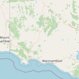
Map view of Glen Roy Conservation Park

Use this park location map to pinpoint Glen Roy Conservation Park in Australia, understand its exact geographic position, and read its mapped placement within the surrounding landscape more clearly.

Pigeon | © OpenStreetMap contributors

Location context for Glen Roy Conservation Park

South Australia
Park atlas

Compare adjacent South Australian reserves and regional dune habitats

Parks Near Glen Roy Conservation Park and Surrounding Protected Landscapes

Browsing parks near Glen Roy Conservation Park reveals broader ecological patterns across the undulating dune country of south-eastern South Australia. Comparing surrounding protected landscapes provides essential regional context for the open forests and seasonal swamps of the local terrain.
National parkSouth Australia
About 9.3 km away#1 closest

North

Naracoorte Caves National Park: Detailed Map and Protected Landscape Context in South Australia

Explore its unique protected geography and natural terrain.

Naracoorte Caves National Park represents a vital protected area within the diverse geography of South Australia. This entry provides an atlas-driven perspective, highlighting its identity as a national park, its mapped landscapes, and its regional significance. Engage with structured information detailing the park's protected status and geographic features, offering a clear view of its contribution to South Australia's natural heritage.

Area
6.6 km²
Established
2001
IUCN
II
Visitors
90.8K annual
Nature reserveSouth Australia
About 15 km away#2 closest

Northwest

Hacks Lagoon Conservation Park: Wetland Landscape and Protected Area Geography

A vital Ramsar wetland site in the South Australia Limestone Coast region

Hacks Lagoon Conservation Park provides a protected freshwater sanctuary amidst the rural plains of South Australia. This nature reserve sustains a diverse wetland habitat, encompassing open water, marshes, and seasonally flooded zones that support critical waterbird populations within an internationally recognized ecological system.

Area
2.02 km²
Established
1967
IUCN
IV
Relief
Lowland
Wildlife reserveSouth Australia
About 23 km away#3 closest

West

Big Heath Conservation Park: Mapping Protected Landscapes in South Australia

A strict nature reserve of woodland and wetland mosaics.

Big Heath Conservation Park represents a significant protected area in the Limestone Coast region of South Australia. The terrain is characterized by a gently undulating plain where subtle variations in elevation and soil composition create a distinct patchwork of eucalypt woodlands, sandy heath, and seasonal depressions linked to regional hydrological drainage systems.

Area
24.72 km²
Established
1964
IUCN
Ia
Relief
Lowland
Nature reserveWattle Range
About 34 km away#4 closest

Southwest

Calectasia Conservation Park: Protected Area Mapping and Landscape Context in Wattle Range

Rare plant habitat and stranded dune ecosystems in South Australia

Calectasia Conservation Park serves as an important protected site within Wattle Range, preserving a delicate balance between seasonally inundated swampland and dry sandy-land woodland. This geographic overview examines the reserve's protected status, its history of habitat management, and the distinct physical terrain that supports a rare population of blue tinsel lily.

Area
0.14 km²
Established
1967
IUCN
IV
Relief
Lowland
Nature reserveSouth Australia
About 45 km away#5 closest

North

Grass Tree Conservation Park: A Protected Nature Reserve in South Australia

Geography and native woodland map exploration.

Grass Tree Conservation Park is a 16 hectare nature reserve in the Limestone Coast of South Australia, focused on the protection of iconic grass trees. The reserve captures a landscape of calcarenite dunes and diverse forest communities, including brown stringybark and pink gum. Through its protected status, it offers valuable insight into the native vegetation and sandy terrain typical of the West Naracoorte Range.

Area
0.16 km²
Established
1972
IUCN
III
Relief
Lowland
Nature reserveSouth Australia
About 53 km away#6 closest

Northwest

Fairview Conservation Park: Protected Nature Reserve and Limestone Coast Geography

Mapped wetlands, sandy ridges, and woodlands in southeastern South Australia

Explore the geographic framework of Fairview Conservation Park, a nature reserve in South Australia's Limestone Coast. The protected area features a unique intersection of semi-permanent lagoons, periodically inundated flats, and varied woodland vegetation including blue gum and manna gum, offering a clear window into the regional geological and ecological character of the area.

Area
13.94 km²
Established
1960
IUCN
Ia
Relief
Lowland
Nature reserveSouth Australia
About 57 km away#7 closest

West

Furner Conservation Park Geography and Protected Woodland Atlas for South Australia

A study of forest remnants, sandy rises, and coastal dune topography

Furner Conservation Park preserves a significant mosaic of native woodlands within the Limestone Coast region. The terrain shifts between sandy rises and stony calcarenite ridges, supporting distinct forest communities that offer a vital look into the natural history and regional geography of South Australia.

Area
2.89 km²
Established
1973
IUCN
III
Relief
Upland
National parkAustralia
About 59 km away#8 closest

Northeast

Little Desert National Park: Victoria's Semi-Arid National Park and Protected Landscape

Explore mapped boundaries and unique mallee heathland ecosystems.

Delve into the protected landscape of Little Desert National Park, a significant national park covering over 1,300 square kilometers of Victoria's semi-arid western region. This area is characterized by its deep sandy soils, mallee heathlands, and diverse wildlife, including important populations of native birds. Understanding its geographic setting and mapped boundaries provides crucial insight into Australia's conservation efforts and the preservation of unique desert ecosystems.

Area
1,326.47 km²
Established
1988
IUCN
II
Visitors
50K annual

Common questions about visiting, size, designation, and location context for Glen Roy Conservation Park

Glen Roy Conservation Park FAQs for park facts, access, geography, and protected area context

Find quick answers about Glen Roy Conservation Park, including protected-area facts, park geography, trail and visitor context, and how the park fits into its surrounding country and regional landscape.
MoriAtlas Explorer

Continue Your Protected Areas Search Across the Global Atlas

Deepen your exploration by continuing the structured search for national parks and protected areas worldwide. Utilize the comprehensive filtering capabilities to compare different conservation landscapes and refine your understanding of global park geography. Discover more about the distribution and characteristics of protected natural areas.

Global natural geography