

Mori Atlas logo
National parkLittle Desert National Park

Discover mapped boundaries and distinct mallee heathland ecosystems in this vast protected area.

Little Desert National Park: Victoria's Semi-Arid National Park Atlas & Landscape

Little Desert National Park represents a significant protected landscape in Victoria, Australia, spanning approximately 1,326 square kilometers of semi-arid wilderness. Its geographic scope stretches from the Wimmera River to the South Australian border, showcasing unique mallee heathland and woodland ecosystems on deep sandy soils. This national park serves as a critical refuge for diverse wildlife, notably supporting populations of threatened bird species, making it a key point of reference for understanding regional conservation geography and natural landscape context.

semi-arid wildernessmallee heathlandImportant Bird Areafour-wheel-drive tracksVictoria national parksdesert ecosystems

Little Desert National Park

National park

Park overview

Structured park overview, official facts, and landscape profile for Little Desert National Park

Little Desert National Park park facts, protected area profile, and essential visitor context

Review the core facts for Little Desert National Park, including designation, size, terrain, visitor scale, habitats, and operating context in one park-focused overview.

About Little Desert National Park

Little Desert National Park represents a unique conservation achievement in Victoria, preserving a landscape that might otherwise have been converted to agricultural farmland during the post-war development boom. The park's semi-arid character distinguishes it from typical Victorian protected areas, offering visitors an opportunity to experience a desert environment within the state. The park is characterized by its distinctive three-block structure, separated by the Nhill-Harrow road and the Kaniva-Edenhope road, which creates distinct visitor experiences ranging from the drier eastern mallee heath to the more vegetated western sections with seasonal swamplands. The deep sandy soils that dominate the landscape present challenges for both agriculture and infrastructure, which contributed to the area remaining relatively undeveloped. Visitors to the park will find a network of four-wheel-drive tracks, several camping areas, and lookouts that provide access to this remote wilderness. The park's visitor numbers of approximately 50,000 annually reflect its importance as a tourism destination in northwestern Victoria, though many internal roads require four-wheel-drive vehicles and some close during winter or after wet weather.

Quick facts and research context for Little Desert National Park

Little Desert National Park occupies a substantial footprint of 132,647 hectares in Victoria's Wimmera Mallee region. The park was formally established in 1988, though conservation efforts began earlier with the Kiata Lowan Sanctuary in 1955 protecting the Eastern Block. The park's ecosystem ranges from mallee heathland in the drier eastern sections to cypress pine and casuarina woodlands in the moister western areas near the South Australian border. Annual rainfall varies significantly across the park, ranging from approximately 400 millimetres in the east to 600 millimetres near Naracoorte. The park is managed by Parks Victoria and receives roughly 50,000 visitors annually who come to experience its four-wheel-drive tracks, camping areas, and walking trails.

Protection and recognition

Verifying official terrestrial boundaries and documented global conservation records

Little Desert National Park Protection Status and Conservation Designation

Analyzing the terrestrial protection status of Little Desert National Park offers baseline clarity on its official regional conservation framework. Documented global registries and official designation records provide essential geographical context regarding the long-term management scope of the park.

Protection details

Protection scope
Terrestrial
Transboundary protection
No
Park context

Deeper park guide and search-rich context for Little Desert National Park

Little Desert National Park history, landscape, wildlife, and travel context

Explore Little Desert National Park through its history, landscape character, ecosystems, wildlife, conservation priorities, cultural context, and seasonal travel timing in a structured park guide built for atlas discovery and search intent.

Why Little Desert National Park stands out

Little Desert National Park is best known for its extensive mallee heathland ecosystems and its role as a critical refuge for threatened bird species, particularly the malleefowl. The park has been identified by BirdLife International as an Important Bird Area due to its populations of malleefowl and diamond firetails. The landscape features characteristic deep sandy soils with low fertility, scattered sandstone outcrops, and seasonal swamplands in the western block. The park's conservation history is notable, as it became a rallying point for Victoria's modern environmental movement in the 1950s when public opposition successfully prevented the subdivision of this fragile land for agriculture. The park also contains remnants of World War II infrastructure, including concrete observation bunkers in the Central Block used historically as a bombing and gunnery range.

Little Desert National Park history and protected-area timeline

The history of Little Desert National Park reflects a significant chapter in Victorian conservation history. Prior to European settlement, Aboriginal family groups camped along the Wimmera River, utilizing the landscape's resources. European activity began in the 1840s with grazing, which continued until the 1960s but proved difficult due to the low-nutrient sandy soils and low rainfall. During World War II, the Central Block was utilized as a bombing and gunnery range, and concrete observation bunkers from this period remain visible in the landscape today. Following the war, the State Government considered clearing and selling the Little Desert region for farming, triggering intense public opposition that gathered support throughout Victoria. The controversy became politically significant when the responsible minister lost his safe seat in a by-election as a result of public outrage over the proposed subdivision. This grassroots movement helped galvanize Victoria's conservation movement, leading to the formation of the Conservation Council of Victoria as a peak body. The Conservation Council's architect, newly appointed Minister William Borthwick, advocated for retaining the area as a nature reserve. In 1955, the Kiata Lowan Sanctuary was established to protect the Eastern Block and its resident malleefowl. This sanctuary became The Little Desert National Park in 1969, and the Central and Western Blocks were added in 1986. In January 2025, a major bushfire burned approximately 70,887 hectares of the park, destroying the Little Desert Nature Lodge and prompting evacuations of nearby Dimboola residents.

Little Desert National Park landscape and geographic character

The physical landscape of Little Desert National Park is defined by its semi-arid character and distinctive soil conditions. The terrain consists mainly of deep sandy soils with very low fertility, interspersed with small pockets of clay soils that create localized variation in the landscape. Occasional rocky sandstone outcrops punctuate the otherwise uniform sandy terrain, while buckshot rises—iron-rich gravel deposits—provide additional topographical variation. The park is relatively flat overall but features subtle undulations that create visual interest across the vast expanse. In the Western Block, large areas of seasonal swampland form over claypans, creating ephemeral wetland environments that fill during wet periods. Laterite deposits are scattered throughout the sandy areas, often characterized by broombush vegetation. The park extends from the Wimmera River in the east to the South Australian border in the west, a span that encompasses significant environmental gradients including rainfall variation that influences vegetation patterns across the three blocks.

Little Desert National Park ecosystems, habitats, and plant life

The ecological character of Little Desert National Park is defined by a gradient from east to west that creates remarkable habitat diversity within a relatively compact protected area. The Eastern Block features pure mallee heathland adapted to the drier conditions and poorer soils, while the moister Western Block supports cypress pine and casuarina woodlands that represent a different ecological community. The annual rainfall gradient from approximately 400 millimetres in the east to 600 millimetres near Naracoorte drives these vegetation patterns, creating distinct ecological zones within the park. The Western Block's seasonal swamplands represent a particularly important habitat type, providing moisture and resources that support different species assemblages than the surrounding arid woodlands. The sandy soils, while challenging for agriculture, support specialized plant communities adapted to low-nutrient conditions and variable rainfall. The park's relatively undisturbed character has allowed these ecological communities to persist in near-natural condition, making it an important reference site for understanding semi-arid ecosystem function in southern Australia.

Little Desert National Park wildlife and species highlights

Little Desert National Park supports remarkable wildlife diversity, with over 200 bird species recorded within its boundaries. The park's significance as an Important Bird Area stems from its populations of malleefowl and diamond firetails, species that depend on the park's unique habitats for their survival. The malleefowl is particularly notable, as this rare bird was a contributory factor in the original decision to preserve the area in 1968, with the Kiata Lowan Sanctuary established specifically to protect this species. The park provides suitable breeding and foraging habitat for these ground-nesting birds within the mallee heathland and woodland environments. Beyond birds, the park supports common mammal species including brush-tailed possums and grey kangaroos that are frequently observed throughout the park. Reptiles are well-represented, with various lizard species commonly basking in the sun along tracks and in open areas. The diverse wildlife assemblages reflect the park's habitat diversity, from the heathland of the Eastern Block to the woodlands and seasonal swamps of the Western Block.

Little Desert National Park conservation status and protection priorities

Little Desert National Park represents a significant conservation achievement, preserving one of Victoria's most ecologically distinctive landscapes. The park's designation as an Important Bird Area by BirdLife International underscores its international significance for threatened bird species, particularly the malleefowl which remains a priority conservation target. The park's conservation history is intertwined with the broader development of environmental policy in Victoria, as the campaign to save the Little Desert from agricultural development helped establish the Land Conservation Council and shaped the state's approach to protected area management. The park preserves relatively intact semi-arid ecosystems that have escaped the extensive land clearing that has transformed much of surrounding agricultural land in the Wimmera Mallee region. This remnant native vegetation provides crucial habitat connectivity and serves as a refuge for species adapted to the challenging desert conditions. The conservation of this landscape also protects important soil and geological features, including the laterite deposits and sandstone outcrops that characterize the area.

Little Desert National Park cultural meaning and human context

The cultural context of Little Desert National Park includes both indigenous heritage and more recent European history. Prior to European settlement, small Aboriginal family groups utilized the landscape along the Wimmera River, which marks the park's eastern boundary. These groups would have relied on the river's resources and the surrounding vegetation for food, shelter, and cultural practices, though detailed records of indigenous use of the Little Desert area are limited. European cultural history is more extensively documented, beginning with grazing in the 1840s that represented the first significant human modification of the landscape. The subsequent attempts to clear and subdivide the land for farming in the post-World War II period sparked the conservation movement that ultimately led to the park's establishment. The remaining concrete bunkers from the World War II bombing range provide physical evidence of a more recent chapter in the region's history, representing military use of the landscape during the 1940s. The conservation debate of the 1950s and 1960s also reflects a broader cultural shift in Victoria toward environmental awareness and advocacy.

Top sights and standout views in Little Desert National Park

Little Desert National Park offers visitors access to Victoria's distinctive semi-arid wilderness with opportunities for four-wheel-drive exploration, wildlife observation, and camping in a remote desert setting. The park's three-block structure provides different experiences, from the mallee heathland of the Eastern Block to the more vegetated Western Block with its seasonal swamplands. The birdlife is exceptional, with over 200 species including the threatened malleefowl making the park a destination for birdwatchers. The historical significance of the conservation campaign that saved this land from development adds depth to visitor experiences, connecting contemporary recreation to Victoria's environmental history. The visible remnants of World War II infrastructure provide additional historical interest, while the network of walking tracks and lookouts offers access to scenic desert landscapes that contrast with typical Victorian natural environments.

Best time to visit Little Desert National Park

The best time to visit Little Desert National Park depends on the type of experience sought, though spring and autumn generally offer the most comfortable conditions for outdoor exploration. The park's semi-arid climate means that summer temperatures can be extreme, potentially making some activities uncomfortable and increasing fire risk during hot, dry periods. Winter brings cooler temperatures but also brings the possibility of road closures due to wet weather and muddy conditions, particularly on the unsealed internal tracks that require four-wheel-drive vehicles. The shoulder seasons of spring and autumn typically provide moderate temperatures suitable for walking, wildlife observation, and camping, though visitors should be aware that some tracks may close after periods of rain regardless of season. The park receives approximately 50,000 visitors annually, with peak visitation during holiday periods and cooler months when conditions are more favorable for extended outdoor activities.
Monthly climate preview

Analyzing long-term temperature ranges and precipitation trends over a thirty-year baseline

Climate Normals and Average Weather by Month for Little Desert National Park

Long-term meteorological baseline data at 134.8 meters elevation reveals a thermal profile peaking above 22 degrees Celsius, contrasted by cool periods where minimums drop near freezing. Accessing the twelve-month profile clarifies the historic precipitation rhythm and temperature shifts that define the local ecology.
Annual mean15 °C
9 °C23 °C
Jan23°
Feb22°
Mar19°
Apr15°
May12°
Jun
Jul
Aug
Sep11°
Oct14°
Nov18°
Dec20°
Warmest month
January

22.6 °C

Coolest month
July

8.6 °C

Wettest month
June

1.7 mm/day

Driest month
March

0.7 mm/day

Park location guide

Geography guide, regional context, and park location map for Little Desert National Park

Little Desert National Park park geography, regions, and map view in Australia

Understand where Little Desert National Park sits in Australia through a broader geographic reading of the surrounding landscape, nearby location context, and its mapped position within the national park landscape.

How Little Desert National Park fits into Australia

Australia is a constitutional monarchy and federal parliamentary democracy comprising six states and ten territories. With a population of nearly 28 million, it is one of the world's most urbanised countries, with most people concentrated on the eastern seaboard. The country has a high Human Development Index and is known for its cultural diversity, ancient Aboriginal heritage, and unique wildlife.

Wider geography shaping Little Desert National Park in Australia

Australia occupies the entire Australian continent, the island of Tasmania, and numerous smaller islands. It is the world's flattest and driest inhabited continent, featuring vast deserts in the interior (the Outback), tropical rainforests along the eastern coast, and a coastline bordering the Indian and Pacific Oceans.

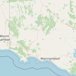
Map view of Little Desert National Park

Use this park location map to pinpoint Little Desert National Park in Australia, understand its exact geographic position, and read its mapped placement within the surrounding landscape more clearly.

Pigeon | © OpenStreetMap contributors
Natural feature types

Explore the Geographic Features and Terrain of Little Desert National Park

Investigate the complex natural geography defining this Australian wilderness. MoriAtlas provides a structured view of the landforms and environmental zones that characterize the three blocks of Little Desert National Park, supporting deeper understanding of its regional terrain.
Recorded earthquake history

Explore Recorded Seismic History Near Little Desert National Park

Examine the historical catalogue of recorded earthquakes and seismic activity associated with the location of Little Desert National Park. MoriAtlas provides a clear view of documented events to support your geographic interest in this protected Victorian wilderness.

Little Desert National Park Earthquake History

Catalogued events

2 events

Strongest magnitude

Magnitude 4.6

Most recent event

Mar 11, 1998

This history includes earthquakes recorded inside the park or within 50 km of its borders

Park atlas

Explore regional protected landscapes and compare mapped park geography across Victoria's semi-arid wilderness.

Discover Other National Parks and Protected Areas Near Little Desert National Park

Continue your atlas journey from Little Desert National Park by exploring other national parks and protected areas within Victoria, focusing on similar mallee heathland and semi-arid wilderness regions. Compare diverse conservation landscapes, trace the regional spread of protected areas, and expand your geographic understanding of Australia's significant natural reserves.
Wildlife reserveSouth Australia
About 4.6 km away#1 closest

Northwest

Custon Conservation Park: Protected Wildlife Reserve and Woodland Landscape in South Australia

Geographic atlas of protected native grassy woodlands and local biodiversity reserves

Custon Conservation Park represents a vital protected land parcel within South Australia, focused on the conservation of endangered Grey-box Grassy Woodland. The site acts as a specialized wildlife reserve where native vegetation associations are preserved through integrated ecological strategies. This detail page offers insight into the park boundaries and regional environmental context of this significant Limestone Coast protected area.

Area
0.64 km²
Established
2007
IUCN
III
Relief
Lowland
Nature reserveSouth Australia
About 10 km away#2 closest

West

Geegeela Conservation Park: Mapped Geography and Protected Area Data

Ecological restoration and woodland habitat in South Australia

Geegeela Conservation Park stands as a significant nature reserve within the Limestone Coast of South Australia. Covering over eight square kilometres, this area protects a regenerating mosaic of desert banksia heath and stringybark woodland, offering a critical refuge for local bird species and nationally endangered fauna within the surrounding rural landscape.

Area
8.58 km²
Established
2005
IUCN
III
Relief
Lowland
Nature reserveSouth Australia
About 29 km away#3 closest

Southwest

Grass Tree Conservation Park: A Protected Nature Reserve in South Australia

Geography and native woodland map exploration.

Grass Tree Conservation Park is a 16 hectare nature reserve in the Limestone Coast of South Australia, focused on the protection of iconic grass trees. The reserve captures a landscape of calcarenite dunes and diverse forest communities, including brown stringybark and pink gum. Through its protected status, it offers valuable insight into the native vegetation and sandy terrain typical of the West Naracoorte Range.

Area
0.16 km²
Established
1972
IUCN
III
Relief
Lowland
National parkSouth Australia
42 km away#4 closest

Southwest

Naracoorte Caves National Park: Detailed Map and Protected Landscape Context in South Australia

Explore its unique protected geography and natural terrain.

Naracoorte Caves National Park represents a vital protected area within the diverse geography of South Australia. This entry provides an atlas-driven perspective, highlighting its identity as a national park, its mapped landscapes, and its regional significance. Engage with structured information detailing the park's protected status and geographic features, offering a clear view of its contribution to South Australia's natural heritage.

Area
6.6 km²
Established
2001
IUCN
II
Visitors
90.8K annual
National parkAustralia
47 km away#5 closest

Southeast

Grampians National Park National Park: Sandstone Ranges and Aboriginal Heritage Atlas

Explore its mapped protected landscape and regional geography.

Grampians National Park stands as a testament to Victoria's natural and cultural heritage, featuring striking sandstone mountain ranges and an exceptional concentration of Aboriginal rock art sites. This protected area offers a deep dive into the region's unique geology, from its ancient sedimentary rock formations to its dramatic cliff faces and peaks. Understanding the park's mapped boundaries and its place within the broader geography provides essential context for appreciating its protected landscape identity and its millennia-long human history.

Area
1,672.19 km²
Established
1984
IUCN
II
Relief
Mountain
Nature reserveSouth Australia
50 km away#6 closest

West

Fairview Conservation Park: Protected Nature Reserve and Limestone Coast Geography

Mapped wetlands, sandy ridges, and woodlands in southeastern South Australia

Explore the geographic framework of Fairview Conservation Park, a nature reserve in South Australia's Limestone Coast. The protected area features a unique intersection of semi-permanent lagoons, periodically inundated flats, and varied woodland vegetation including blue gum and manna gum, offering a clear window into the regional geological and ecological character of the area.

Area
13.94 km²
Established
1960
IUCN
Ia
Relief
Lowland
Nature reserveSouth Australia
52 km away#7 closest

Southwest

Hacks Lagoon Conservation Park: Wetland Landscape and Protected Area Geography

A vital Ramsar wetland site in the South Australia Limestone Coast region

Hacks Lagoon Conservation Park provides a protected freshwater sanctuary amidst the rural plains of South Australia. This nature reserve sustains a diverse wetland habitat, encompassing open water, marshes, and seasonally flooded zones that support critical waterbird populations within an internationally recognized ecological system.

Area
2.02 km²
Established
1967
IUCN
IV
Relief
Lowland
National parkAustralia
54 km away#8 closest

Northeast

Wyperfeld National Park: Mapping Victoria's Vast Mallee Semi-Arid Wilderness and Sandhill Landscapes

Discover the unique geography and protected terrain of this significant Australian national park.

Wyperfeld National Park in Victoria, Australia, is a prime example of a vast semi-arid wilderness landscape. It is best known for its extensive sandhill formations, referred to as 'snowdrifts,' which punctuate the otherwise flat terrain. The park also protects a significant ephemeral lake system and is a stronghold for the mallee ecosystem, offering a unique context for understanding dryland conservation and mapped natural areas. Its protected status highlights its importance within the broader geographic context of Australia's protected landscapes.

Area
3,570 km²
Established
1921
IUCN
II
Relief
Lowland

Common questions about visiting, size, designation, and location context for Little Desert National Park

Little Desert National Park FAQs for park facts, access, geography, and protected area context

Find quick answers about Little Desert National Park, including protected-area facts, park geography, trail and visitor context, and how the park fits into its surrounding country and regional landscape.
MoriAtlas Explorer

Continue Your Protected Areas Search Across the Global Atlas

Deepen your exploration by continuing the structured search for national parks and protected areas worldwide. Utilize the comprehensive filtering capabilities to compare different conservation landscapes and refine your understanding of global park geography. Discover more about the distribution and characteristics of protected natural areas.

Global natural geography