

Mori Atlas logo
National parkCanunda National Park

Discover the mapped boundaries and regional natural geography of this national park.

Canunda National Park: Protected Landscape and Geographic Atlas Context in South Australia

Canunda National Park stands as a significant protected area within the diverse geography of South Australia. This page offers an atlas-driven perspective, detailing the park's protected landscape, its specific mapped boundaries, and its regional natural context. Explore what makes Canunda National Park a distinct natural entity within the broader Australian landscape through structured geographic data.

Coastal DunesLimestone CliffsAboriginal HeritageFour Wheel Drive AccessSouthern OceanSouth Australia

Canunda National Park

National park

Park overview

Structured park overview, official facts, and landscape profile for Canunda National Park

Canunda National Park park facts, protected area profile, and essential visitor context
Review the core facts for Canunda National Park, including designation, size, terrain, visitor scale, habitats, and operating context in one park-focused overview.

About Canunda National Park

Canunda National Park occupies a distinctive position on South Australia's south-eastern coastline, where the Southern Ocean sculpts a landscape of limestone cliffs, shifting sand dunes, and hardy coastal bushland. The park's two sections stretch along the coast from the vicinity of Southend in the north to Carpenter Rocks and Cape Banks in the south, protecting a representative sample of the Limestone Coast's natural character. The limestone formations that give the region its name create dramatic cliff faces and rocky outcrops that are characteristic of this part of the South Australian coast. Behind the shoreline, extensive dune systems have formed over millennia, supporting specialized vegetation communities adapted to unstable sandy substrates and exposure to coastal winds. The inland portions of the park consist of denser bushland, providing contrast to the more exposed coastal zones. Access to most of the park requires four-wheel drive vehicles or foot travel along rough tracks, maintaining a sense of remoteness that distinguishes Canunda from more developed protected areas. The park's office located in Southend serves as the primary visitor services point for this largely undeveloped coastal reserve.

Quick facts and research context for Canunda National Park

Canunda National Park occupies a coastal strip along the Southern Ocean in South Australia's Limestone Coast region, approximately 13 kilometres southwest of Millicent. The park protects coastal dunes, limestone cliffs, and native bushland across two disconnected sections spanning a total of 96.24 square kilometres. It holds IUCN Category VI status as a protected area with sustainable use of natural resources. The park's office is located in the town of Southend at the northern end of the park. The northern section was historically part of Mayurra Station, with remnants of this pastoral era visible at Coola Outstation.

Park context

Deeper park guide and search-rich context for Canunda National Park

Canunda National Park history, landscape, wildlife, and travel context
Explore Canunda National Park through its history, landscape character, ecosystems, wildlife, conservation priorities, cultural context, and seasonal travel timing in a structured park guide built for atlas discovery and search intent.

Why Canunda National Park stands out

Canunda National Park is best known for its dramatic limestone cliff formations such as Mounce and Battye Rocks, which create a striking coastal skyline against the Southern Ocean. The park's extensive coastal dune systems and the remote, rugged nature of its beaches distinguish it from other South Australian protected areas. Perhaps most significantly, the park preserves tangible evidence of continuous Boandik Aboriginal occupation spanning at least 10,000 years, making it a place of both geological and cultural significance on the Limestone Coast.

Canunda National Park history and protected-area timeline

The land now within Canunda National Park has a human history extending back at least 10,000 years, with the Boandik group of Indigenous Australians establishing a strong cultural connection to this coastal landscape. Archaeological evidence and historical records indicate that Boandik people occupied temporary camps along the coastline during summer months, taking advantage of marine resources and favourable conditions. For the remainder of the year, they relocated to areas near inland swamps where they built more permanent hut structures known as wurlies or humpies. This seasonal movement pattern reflects a sophisticated understanding of the landscape's resources and ecological cycles, demonstrating how the Boandik people adapted their settlement patterns to the changing conditions throughout the year. European settlement of the region began in the nineteenth century, with the northern portion of what is now the park forming part of Mayurra Station, a pastoral holding that shaped the landscape before protection was established. The remnant structures of Coola Outstation provide physical evidence of this pastoral era, offering a window into a more recent chapter of human history on the land. Canunda National Park was formally established on 20 August 1959, creating the protected area that preserves both the natural landscape and the deep Aboriginal heritage of the coast.

Canunda National Park landscape and geographic character

The landscape of Canunda National Park is defined by the interaction between the Southern Ocean and the limestone geology of the Limestone Coast. Prominent limestone cliffs rise along sections of the coastline, with formations such as Mounce Rocks and Battye Rocks creating distinctive visual landmarks within the park. These cliff formations have been shaped by wave action and weathering, exposing fossil-rich limestone that documents the region's geological history. Behind the cliffs, extensive coastal dune systems have developed, their exact configuration shaped by prevailing winds and the dynamic nature of beach systems. The dunes support sparse but specialized vegetation adapted to sandy, nutrient-poor conditions. Inland from the shoreline, the terrain transitions to denser bushland dominated by native shrubs and eucalyptus species typical of the lower south-east of South Australia. The southern section of the park at Cape Banks provides an elevated headland perspective from which visitors can view the open ocean and appreciate the scale of the coastal landscape. Overall, the park presents a landscape of stark beauty where geological forces and coastal processes continue to shape the terrain.

Canunda National Park ecosystems, habitats, and plant life

The natural environment of Canunda National Park reflects the challenging conditions of a temperate coastal setting exposed to the Southern Ocean. The vegetation communities within the park are adapted to wind exposure, salt spray, and the sandy or limestone-based soils that characterize the Limestone Coast. Coastal dune vegetation dominates the foredune areas, consisting of specialized grasses and low shrubs capable of surviving in unstable sand. The limestone cliff areas support distinctive plant assemblages able to anchor themselves in rocky crevices and take advantage of the mineral-rich substrate. Behind the immediate coastal zones, the park's bushland areas contain a mix of mallee eucalyptus species, Banksia, and various shrubs that have developed in response to the region's Mediterranean-style climate. While the source material does not provide detailed ecological inventories, the park's protected status ensures the preservation of these coastal ecosystems and the habitat they provide for native species.

Canunda National Park wildlife and species highlights

While the source material does not provide detailed wildlife documentation, Canunda National Park's diverse coastal and bushland habitats support various native species typical of the South Australian Limestone Coast region. The coastal environment provides feeding and resting opportunities for seabirds, while the dune and cliff systems offer nesting habitat for shorebird species. The bushland areas within the park provide shelter for woodland birds and small mammals adapted to the dense shrub layer. Marine mammals may be observed offshore where the Southern Ocean provides foraging grounds. The park's protected status helps maintain these habitats and the wildlife populations they support, though detailed species records would require additional sources.

Canunda National Park conservation status and protection priorities

Canunda National Park contributes to the protection of South Australia's coastal natural heritage within the Limestone Coast region. As an IUCN Category VI protected area, the park is designated for the preservation of natural ecosystems while allowing for sustainable use of natural resources where appropriate. The protection of coastal dune systems, limestone cliff habitats, and the adjoining bushland ensures that representative examples of the region's natural landscapes are preserved for future generations. The park also plays a role in conserving the cultural heritage of the Boandik people, with the landscape holding archaeological and cultural values that benefit from the protected area status. Management of the park by the South Australian Department of Environment and Water balances visitor access with the need to protect the park's natural and cultural values, particularly given the fragility of coastal dune systems and the significance of Aboriginal heritage sites.

Canunda National Park cultural meaning and human context

The cultural context of Canunda National Park is deeply shaped by the long-standing connection of the Boandik people to this coastline. For at least ten thousand years, the Boandik group maintained a presence along the coast, establishing seasonal camps and utilizing the diverse resources of the marine and terrestrial environments. Their settlement pattern of summer coastal camps followed by relocation to inland swamp areas during other seasons demonstrates a complex relationship with the landscape that was intimately connected to ecological conditions and resource availability. The traditional structures known as wurlies or humpies represent the material heritage of this Aboriginal occupation, though physical evidence of these temporary structures is less visible than the landscape itself. This Aboriginal heritage gives the park significance beyond its geological and ecological values, connecting the protected landscape to a continuous cultural tradition spanning millennia. The more recent pastoral history, evidenced by the remnants of Coola Outstation from the Mayurra Station era, adds another layer to the human story of this coastline.

Top sights and standout views in Canunda National Park

The dramatic limestone cliffs of Mounce and Battye Rocks stand as the most visually striking features within Canunda National Park, providing iconic views of the Southern Ocean from the cliff tops. The extensive coastal dune systems offer a distinctive landscape type within the South Australian protected area network, with their dynamic and evolving form contrasting sharply with the more stable terrain of inland parks. The park's Boandik heritage spanning at least 10,000 years represents an extraordinary depth of Aboriginal connection to the coastal landscape, distinguishing Canunda from many other Australian national parks. The remote and rugged nature of most of the park, accessible primarily by four-wheel drive, provides a sense of wilderness that remains relatively rare along the developed South Australian coastline. The remnant pastoral structures at Coola Outstation offer an additional historical layer visible within the park.

Best time to visit Canunda National Park

The summer months from December through February generally offer the most comfortable conditions for exploring Canunda National Park, with longer daylight hours and warmer temperatures suitable for beach activities and coastal walks. However, the park's exposed coastline means that conditions can change rapidly, and visitors should be prepared for wind and variable weather at any time of year. The cooler months from late autumn through early spring may provide more stable conditions for bushwalking in the inland sections of the park, though rainfall can affect track conditions, particularly for two-wheel drive access. Visitors planning beach activities should always check current conditions and be aware of the dangerous beach conditions that the park is known for, regardless of the season.
Park location guide

Geography guide, regional context, and park location map for Canunda National Park

Canunda National Park park geography, regions, and map view in Australia
Understand where Canunda National Park sits in Australia through a broader geographic reading of the surrounding landscape, nearby location context, and its mapped position within the national park landscape.

How Canunda National Park fits into Australia

Australia is a constitutional monarchy and federal parliamentary democracy comprising six states and ten territories. With a population of nearly 28 million, it is one of the world's most urbanised countries, with most people concentrated on the eastern seaboard. The country has a high Human Development Index and is known for its cultural diversity, ancient Aboriginal heritage, and unique wildlife.

Wider geography shaping Canunda National Park in Australia

Australia occupies the entire Australian continent, the island of Tasmania, and numerous smaller islands. It is the world's flattest and driest inhabited continent, featuring vast deserts in the interior (the Outback), tropical rainforests along the eastern coast, and a coastline bordering the Indian and Pacific Oceans.

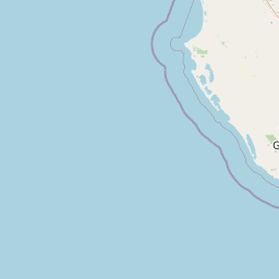
Map view of Canunda National Park

Use this park location map to pinpoint Canunda National Park in Australia, understand its exact geographic position, and read its mapped placement within the surrounding landscape more clearly.

Pigeon | © OpenStreetMap contributors

Location context for Canunda National Park

South Australia
Park atlas

Uncover the broader geographic spread of protected landscapes near Canunda National Park.

Explore Related National Parks and Protected Areas Near Canunda National Park
Browse a curated selection of national parks and protected areas geographically close to Canunda National Park, including diverse coastal and bushland environments. Compare their unique landscape features, conservation status, and regional context to enhance your understanding of South Australia's protected areas.
National parkSouth Australia

Naracoorte Caves National Park: Detailed Map and Protected Landscape Context in South Australia

Explore its unique protected geography and natural terrain.

Naracoorte Caves National Park represents a vital protected area within the diverse geography of South Australia. This entry provides an atlas-driven perspective, highlighting its identity as a national park, its mapped landscapes, and its regional significance. Engage with structured information detailing the park's protected status and geographic features, offering a clear view of its contribution to South Australia's natural heritage.

Area
6.6 km²
Established
2001
IUCN
II
Visitors
90.8K annual
National park

Lower Glenelg National Park: Dramatic River Gorge and Limestone Cave Protected Landscape

Explore its mapped boundaries and unique geological features.

Lower Glenelg National Park in Victoria, Australia, is a national park celebrated for its visually stunning Glenelg River gorge. This protected area showcases millions of years of geological history etched into its limestone cliffs and features the accessible Princess Margaret Rose Cave. Understand the park's mapped landscape, its diverse terrain from riverine woodlands to coastal wetlands, and its significance within regional geographic exploration.

Area
273 km²
Established
1969
IUCN
II
Visitors
200K annual
National parkBarwon South West

Cobboboonee National Park: A Protected Landscape in Australia's Barwon South West Region

Explore its mapped geography and natural terrain.

Cobboboonee National Park represents an important protected area within the Barwon South West region of Australia. This destination offers users a deep dive into the park's specific geography, providing context on its mapped boundaries and the surrounding natural landscapes. It is designed for exploration of the park's protected-area identity and its place within the regional geography, offering structured data for landscape context.

Area
185.1 km²
Established
2008
IUCN
II
Climate
Temperate
National park

Mount Richmond National Park: Protected Area Atlas and Southwest Victoria Landscape

Explore mapped terrain and coastal woodland ecosystems.

Mount Richmond National Park is a vital protected area in Victoria's southwest, safeguarding coastal woodland and heath remnants on the region's volcanic plains. As a component of Victoria's national park system, it provides a geographically specific example of a protected landscape, contributing to the regional atlas of natural environments. Its landscape character is defined by eucalyptus woodlands and coastal influences, offering context for understanding conservation corridors and the mapped natural terrain of the southwestern Victorian coast. The park’s inclusion in long-distance walking routes also underscores its value for exploring protected natural areas.

Area
17.33 km²
Established
1960
IUCN
II
Relief
Mixed relief
National park

Discovery Bay Marine National Park: Victoria's Protected Coastal Marine Landscape

Mapped protected waters adjacent to Cape Bridgewater's unique geography.

Discover the geographic scope and protected landscape identity of Discovery Bay Marine National Park, an important marine national park located in Victoria, Australia, near Portland. This protected area safeguards a crucial stretch of the country's southern coastline, contributing to the ecological significance of the Southern Ocean marine region. Its position adjacent to the Discovery Bay Coastal Park highlights an integrated conservation approach, offering users a detailed view of its mapped marine boundaries and the distinctive geological context of the Cape Bridgewater area for atlas exploration.

Area
27.7 km²
Established
2002
IUCN
II
Climate
Temperate
National park

Little Desert National Park: Victoria's Semi-Arid National Park and Protected Landscape

Explore mapped boundaries and unique mallee heathland ecosystems.

Delve into the protected landscape of Little Desert National Park, a significant national park covering over 1,300 square kilometers of Victoria's semi-arid western region. This area is characterized by its deep sandy soils, mallee heathlands, and diverse wildlife, including important populations of native birds. Understanding its geographic setting and mapped boundaries provides crucial insight into Australia's conservation efforts and the preservation of unique desert ecosystems.

Area
1,326.47 km²
Established
1988
IUCN
II
Visitors
50K annual
National park

Budj Bim National Park: Ancient Volcanic Landscapes and World Heritage Protected Area

Explore the unique geography of Budj Bim National Park's crater lakes and lava tubes.

Budj Bim National Park offers an exceptional exploration of volcanic geography and ancient human ingenuity. This protected area features a dramatic landscape dominated by volcanic cones, lava tubes, and the picturesque Lake Surprise crater lake. Its significance is amplified by the presence of sophisticated Aboriginal aquaculture systems, developed thousands of years ago by the Gunditjmara people, which have contributed to its UNESCO World Heritage status. Discover the mapped terrain and protected land context of this geologically and culturally rich Australian national park.

Area
54.7 km²
Established
1960
IUCN
II
Relief
Mixed relief
National parkSouth Australia

Coorong National Park: South Australia National Park Mapped Boundaries and Landscape Context

Explore its unique protected landscape and regional geography.

Coorong National Park in South Australia is featured here as a key protected area for geographic discovery. Users can explore the park's specific landscape characteristics, mapped boundaries, and its role within the regional geography of South Australia. This detail page supports an atlas-based understanding of protected lands, offering a focused perspective on the park's natural terrain and conservation significance within Australia.

Area
490.15 km²
Established
1967
IUCN
II
Relief
Lowland

Common questions about visiting, size, designation, and location context for Canunda National Park

Canunda National Park FAQs for park facts, access, geography, and protected area context
Find quick answers about Canunda National Park, including protected-area facts, park geography, trail and visitor context, and how the park fits into its surrounding country and regional landscape.
MoriAtlas Explorer

Continue Your Protected Areas Search Across the Global Atlas

Deepen your exploration by continuing the structured search for national parks and protected areas worldwide. Utilize the comprehensive filtering capabilities to compare different conservation landscapes and refine your understanding of global park geography. Discover more about the distribution and characteristics of protected natural areas.

Global natural geography