

Mori Atlas logo
National parkCobboboonee National Park

Trace the mapped boundaries and explore the natural terrain of this Australian national park.

Cobboboonee National Park: Discover Its Protected Landscape and Geographic Context in Barwon South West

Cobboboonee National Park stands as a key protected area within Australia's Barwon South West region. This page provides an atlas-focused exploration of its distinct geographic identity, allowing for a clear understanding of its mapped boundaries and the natural landscapes it encompasses. Engage with detailed geographic information and discover the park's significance as a conservation landscape.

Wetland ecosystemsLong-distance walking trackIndigenous heritageVictoria national parksSwamp and marshlandGreat South West Walk

Cobboboonee National Park

National park

Park overview

Structured park overview, official facts, and landscape profile for Cobboboonee National Park

Cobboboonee National Park park facts, protected area profile, and essential visitor context
Review the core facts for Cobboboonee National Park, including designation, size, terrain, visitor scale, habitats, and operating context in one park-focused overview.

About Cobboboonee National Park

Cobboboonee National Park represents Victoria's commitment to protecting the natural and cultural heritage of the state's southwestern region. The park's establishment in 2008 marked a significant conservation milestone, transforming what was previously Cobboboonee State Forest into a formally protected national park with stronger legal protections and management focus. The park is managed by Parks Victoria, which oversees visitor access, conservation programs, and heritage protection within the reserve. Located in the Barwon South West region, the park sits in a landscape characterized by rolling terrain, extensive wetland systems, and forested areas that support numerous species. The proximity to the Lower Glenelg National Park to the west creates a corridor of protected land that supports ecological connectivity across the broader southwest Victorian landscape. The park serves as an important refuge for native wildlife and represents a piece of Victoria's natural heritage that was previously under-protected as state forest.

Quick facts and research context for Cobboboonee National Park

Cobboboonee National Park spans 18,510 hectares in Victoria's Barwon South West region, making it a substantial protected area in the state's southwest. The park was proclaimed in November 2008, transitioning from former State Forest status to full national park protection. The Fitzroy River originates from the swamps within the park boundaries, feeding downstream ecosystems. A section of the Great South West Walk long-distance trail traverses the park, providing visitors with opportunities to explore this relatively new addition to Victoria's national park system.

Park context

Deeper park guide and search-rich context for Cobboboonee National Park

Cobboboonee National Park history, landscape, wildlife, and travel context
Explore Cobboboonee National Park through its history, landscape character, ecosystems, wildlife, conservation priorities, cultural context, and seasonal travel timing in a structured park guide built for atlas discovery and search intent.

Why Cobboboonee National Park stands out

Cobboboonee National Park is distinguished by its extensive swamp ecosystems and the origin point of the Fitzroy River, which rises from wetland areas within the park. The park protects one of the more significant wetland complexes in Victoria's southwest, supporting diverse habitats and wildlife populations. The Great South Walk, one of Victoria's premier long-distance walking tracks, passes through the park, offering visitors immersive access to its landscapes. Additionally, the park holds deep cultural significance as traditional Gunditjmara country, with the area representing the continuing connection of Indigenous Australians to this landscape.

Cobboboonee National Park history and protected-area timeline

The land now comprising Cobboboonee National Park was historically managed as Cobboboonee State Forest prior to its proclamation as a national park in November 2008. This transition reflected a broader shift in Victoria's conservation policy, moving from primarily timber production and resource extraction uses toward ecosystem protection and public recreation values. The change from State Forest to National Park status brought increased legal protections for the area's natural values and shifted management priorities from commercial forestry to conservation, visitor experience, and Indigenous heritage management. The park is situated in the traditional Country of the Gunditjmara people, whose connection to this landscape extends back many thousands of years before European settlement and continues today.

Cobboboonee National Park landscape and geographic character

The terrain of Cobboboonee National Park encompasses a mix of wetland, forest, and open woodland environments characteristic of southwest Victoria. The park's landscape is defined in significant part by its extensive swamp systems, which serve as the source and catchment areas for the Fitzroy River as it begins its journey toward the sea. The swamps create a complex hydrological system that supports specialized vegetation and provides critical habitat for water-dependent species. The park's position north of Portland places it in a region where the climate and geography create conditions suitable for diverse plant communities. The landscape provides visual variety through the contrast of wetland areas against more elevated forested sections, creating an environment that supports ecological diversity while offering visitors scenic natural landscapes.

Cobboboonee National Park ecosystems, habitats, and plant life

The ecological character of Cobboboonee National Park centers on its wetland systems, which represent some of the more significant swamp habitats in Victoria's southwest. These wetlands support specialized plant communities adapted to periodic flooding and saturated soils, creating environments that differ markedly from the surrounding agricultural landscape. The swamp ecosystems provide critical functions including water filtration, flood control, and habitat provision for numerous species. The riparian zones along watercourses support different vegetation types, creating corridors of habitat that connect wetland areas through the broader landscape. The park's protected status ensures these ecological communities receive formal recognition and management attention that they would not receive as working state forest.

Cobboboonee National Park wildlife and species highlights

The wetlands and forests of Cobboboonee National Park support populations of native wildlife adapted to southwest Victorian conditions. The swamp environments provide important habitat for waterbirds, including species that rely on wetland areas for feeding and breeding. The diverse habitat types within the park, ranging from wetland to forest, support varied fauna communities. Riparian areas along the Fitzroy River and its tributaries offer productive environments for aquatic species and the predators that depend on them. The protected area provides refuge for wildlife in a landscape increasingly modified by agriculture, making the park significant for biodiversity conservation in the broader region.

Cobboboonee National Park conservation status and protection priorities

Cobboboonee National Park contributes to Victoria's protected area network by preserving representative examples of southwest Victorian ecosystems. The formal protection of this land in 2008 addressed a gap in the conservation estate, ensuring the swamp systems, forests, and wildlife populations of the Cobboboonee area receive dedicated management and legal protection. The park connects with the adjacent Lower Glenelg National Park, creating a larger complex of protected land that supports ecological processes across broader spatial scales. Wetland conservation is particularly significant given the extensive drainage and modification of wetlands throughout Victoria's agricultural regions. The park protects the headwaters and catchment of the Fitzroy River, safeguarding water quality and ecosystem function downstream.

Cobboboonee National Park cultural meaning and human context

The Gunditjmara people hold traditional ownership and connection to the land containing Cobboboonee National Park. This Indigenous connection represents one of the longest continuous cultural associations with Australian landscapes, extending back many thousands of years. The Gunditjmara people's traditional use and management of this Country reflects deep knowledge of local ecosystems, seasonal patterns, and sustainable land practices. The park's establishment as a protected area intersects with contemporary recognition of Indigenous rights and interests in land management. Traditional Owner involvement in park management reflects evolving approaches to protected area governance that acknowledge Indigenous peoples as partners in conservation.

Top sights and standout views in Cobboboonee National Park

Cobboboonee National Park offers visitors the opportunity to explore one of Victoria's newer national parks through the Great South West Walk, which passes through the park and provides access to its diverse landscapes. The Fitzroy River, rising from park wetlands, creates opportunities to observe river ecosystems in their natural state within a protected landscape. The park's swamp environments represent distinctive wetland character not commonly found in other Victorian national parks. The Indigenous heritage context adds cultural depth to the visitor experience, connecting modern recreation with the ancient Gunditjmara connection to this Country.

Best time to visit Cobboboonee National Park

The park can be visited throughout the year, though seasonal conditions influence the experience. Autumn and winter months often see higher water levels in the swamp systems, enhancing wetland character and wildlife viewing opportunities. Spring brings milder weather and can offer pleasant conditions for walking the Great South West Walk trail. Summer months may provide warmer conditions but the park's wetlands and forest environments can still be explored. Visitors planning walks or extended time in the park should check current conditions with Parks Victoria before traveling.
Park location guide

Geography guide, regional context, and park location map for Cobboboonee National Park

Cobboboonee National Park park geography, regions, and map view in Australia
Understand where Cobboboonee National Park sits in Australia through a broader geographic reading of the surrounding landscape, nearby location context, and its mapped position within the national park landscape.

How Cobboboonee National Park fits into Australia

Australia is a constitutional monarchy and federal parliamentary democracy comprising six states and ten territories. With a population of nearly 28 million, it is one of the world's most urbanised countries, with most people concentrated on the eastern seaboard. The country has a high Human Development Index and is known for its cultural diversity, ancient Aboriginal heritage, and unique wildlife.

Wider geography shaping Cobboboonee National Park in Australia

Australia occupies the entire Australian continent, the island of Tasmania, and numerous smaller islands. It is the world's flattest and driest inhabited continent, featuring vast deserts in the interior (the Outback), tropical rainforests along the eastern coast, and a coastline bordering the Indian and Pacific Oceans.

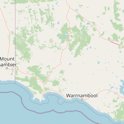
Map view of Cobboboonee National Park

Use this park location map to pinpoint Cobboboonee National Park in Australia, understand its exact geographic position, and read its mapped placement within the surrounding landscape more clearly.

Pigeon | © OpenStreetMap contributors

Location context for Cobboboonee National Park

Barwon South West
Park atlas

Explore Regional Protected Landscapes and Wetland Ecosystems Surrounding Cobboboonee

Discover Nearby National Parks and Protected Areas Beyond Cobboboonee National Park, Victoria, Australia
Explore national parks and protected areas surrounding Cobboboonee National Park, revealing the diverse geographic context of southwest Victoria, including wetland systems and forested landscapes. Compare these regional conservation zones to understand the distribution of unique ecosystems and the comprehensive protected-area atlas of Australia's natural heritage.
National park

Lower Glenelg National Park: Dramatic River Gorge and Limestone Cave Protected Landscape

Explore its mapped boundaries and unique geological features.

Lower Glenelg National Park in Victoria, Australia, is a national park celebrated for its visually stunning Glenelg River gorge. This protected area showcases millions of years of geological history etched into its limestone cliffs and features the accessible Princess Margaret Rose Cave. Understand the park's mapped landscape, its diverse terrain from riverine woodlands to coastal wetlands, and its significance within regional geographic exploration.

Area
273 km²
Established
1969
IUCN
II
Visitors
200K annual
National park

Mount Richmond National Park: Protected Area Atlas and Southwest Victoria Landscape

Explore mapped terrain and coastal woodland ecosystems.

Mount Richmond National Park is a vital protected area in Victoria's southwest, safeguarding coastal woodland and heath remnants on the region's volcanic plains. As a component of Victoria's national park system, it provides a geographically specific example of a protected landscape, contributing to the regional atlas of natural environments. Its landscape character is defined by eucalyptus woodlands and coastal influences, offering context for understanding conservation corridors and the mapped natural terrain of the southwestern Victorian coast. The park’s inclusion in long-distance walking routes also underscores its value for exploring protected natural areas.

Area
17.33 km²
Established
1960
IUCN
II
Relief
Mixed relief
National park

Discovery Bay Marine National Park: Victoria's Protected Coastal Marine Landscape

Mapped protected waters adjacent to Cape Bridgewater's unique geography.

Discover the geographic scope and protected landscape identity of Discovery Bay Marine National Park, an important marine national park located in Victoria, Australia, near Portland. This protected area safeguards a crucial stretch of the country's southern coastline, contributing to the ecological significance of the Southern Ocean marine region. Its position adjacent to the Discovery Bay Coastal Park highlights an integrated conservation approach, offering users a detailed view of its mapped marine boundaries and the distinctive geological context of the Cape Bridgewater area for atlas exploration.

Area
27.7 km²
Established
2002
IUCN
II
Climate
Temperate
National park

Budj Bim National Park: Ancient Volcanic Landscapes and World Heritage Protected Area

Explore the unique geography of Budj Bim National Park's crater lakes and lava tubes.

Budj Bim National Park offers an exceptional exploration of volcanic geography and ancient human ingenuity. This protected area features a dramatic landscape dominated by volcanic cones, lava tubes, and the picturesque Lake Surprise crater lake. Its significance is amplified by the presence of sophisticated Aboriginal aquaculture systems, developed thousands of years ago by the Gunditjmara people, which have contributed to its UNESCO World Heritage status. Discover the mapped terrain and protected land context of this geologically and culturally rich Australian national park.

Area
54.7 km²
Established
1960
IUCN
II
Relief
Mixed relief
National parkSouth Australia

Canunda National Park: South Australia's Protected Landscape and Geographic Atlas

Explore mapped boundaries and regional natural geography.

Canunda National Park in South Australia is presented here as a distinct protected landscape. This detail page focuses on its geographic setting, providing insights into its mapped boundaries and its role within the regional atlas context. Understand the park's natural geography and its protected status for informed exploration.

Area
96.24 km²
Established
1959
IUCN
VI
Relief
Lowland
National park

Grampians National Park National Park: Sandstone Ranges and Aboriginal Heritage Atlas

Explore its mapped protected landscape and regional geography.

Grampians National Park stands as a testament to Victoria's natural and cultural heritage, featuring striking sandstone mountain ranges and an exceptional concentration of Aboriginal rock art sites. This protected area offers a deep dive into the region's unique geology, from its ancient sedimentary rock formations to its dramatic cliff faces and peaks. Understanding the park's mapped boundaries and its place within the broader geography provides essential context for appreciating its protected landscape identity and its millennia-long human history.

Area
1,672.19 km²
Established
1984
IUCN
II
Relief
Mountain
National parkSouth Australia

Naracoorte Caves National Park: Detailed Map and Protected Landscape Context in South Australia

Explore its unique protected geography and natural terrain.

Naracoorte Caves National Park represents a vital protected area within the diverse geography of South Australia. This entry provides an atlas-driven perspective, highlighting its identity as a national park, its mapped landscapes, and its regional significance. Engage with structured information detailing the park's protected status and geographic features, offering a clear view of its contribution to South Australia's natural heritage.

Area
6.6 km²
Established
2001
IUCN
II
Visitors
90.8K annual
National park

Port Campbell National Park: Iconic Limestone Cliffs and Coastal Protected Area

Explore the mapped geography of Victoria's dramatic Shipwreck Coast.

Port Campbell National Park, a prominent national park in Victoria, Australia, offers an unparalleled atlas exploration of coastal geology. Its landscape is defined by towering limestone cliffs, iconic offshore rock stacks such as the Twelve Apostles, and numerous natural arches and blowholes sculpted by the Southern Ocean. This protected area provides critical geographic context for the Shipwreck Coast's dramatic terrain and serves as a focal point for understanding Australia's dynamic natural heritage.

Area
17.5 km²
Established
1964
IUCN
II
Visitors
2M annual

Common questions about visiting, size, designation, and location context for Cobboboonee National Park

Cobboboonee National Park FAQs for park facts, access, geography, and protected area context
Find quick answers about Cobboboonee National Park, including protected-area facts, park geography, trail and visitor context, and how the park fits into its surrounding country and regional landscape.
MoriAtlas Explorer

Continue Your Protected Areas Search Across the Global Atlas

Deepen your exploration by continuing the structured search for national parks and protected areas worldwide. Utilize the comprehensive filtering capabilities to compare different conservation landscapes and refine your understanding of global park geography. Discover more about the distribution and characteristics of protected natural areas.

Global natural geography