

Mori Atlas logo
National parkBudj Bim National Park

Discover the unique geography of Budj Bim National Park and its dramatic crater lakes and lava tubes.

Budj Bim National Park: Ancient Volcanic Landscape and World Heritage Protected Area

Budj Bim National Park, located in Victoria, Australia, preserves a remarkable ancient volcanic landscape shaped by millennia of geological activity. This protected area showcases dramatic features such as lava tubes, the striking Lake Surprise crater lake, and the extensive, ancient aquaculture systems engineered by the Gunditjmara people. As part of the Budj Bim Cultural Landscape, recognized for its World Heritage status, the park offers profound insights into both geological processes and Indigenous heritage, making it a key destination for understanding protected lands and regional geography.

Volcanic landscapesWorld Heritage sitesAboriginal heritageLava tubesCrater lakesIndigenous history

Budj Bim National Park

National park

Park overview

Structured park overview, official facts, and landscape profile for Budj Bim National Park

Budj Bim National Park park facts, protected area profile, and essential visitor context

Review the core facts for Budj Bim National Park, including designation, size, terrain, visitor scale, habitats, and operating context in one park-focused overview.

About Budj Bim National Park

Budj Bim National Park occupies a distinctive place in Australia's protected area network by combining remarkable volcanic geology with profound Indigenous heritage. The park is centered on Budj Bim, an ancient volcano that dominates the surrounding landscape of the Western District of Victoria. Unlike many of Australia's more ancient volcanic regions, Budj Bim represents one of the most recent periods of volcanic activity on the continent, with eruptions occurring as recently as 8,000 years ago. This relatively recent geological activity has left the landscape remarkably well-preserved, with clear volcanic features including craters, lava flows, and the iconic Lake Surprise. The park forms part of a larger cultural landscape that extends beyond its boundaries, recognized for the extensive Aboriginal engineering achievements preserved within and around the protected area. The Gunditjmara people developed sophisticated aquaculture systems over thousands of years, constructing stone fish traps and channels that allowed them to sustainably harvest fish from the region's waterways. These achievements represent not only technical ingenuity but also a deep understanding of the local environment and sustainable resource management. Today, the park provides visitors with the opportunity to experience both the natural wonders of the volcanic landscape and the rich cultural heritage of the Gunditjmara people.

Quick facts and research context for Budj Bim National Park

Budj Bim National Park covers 5,470 hectares in southwestern Victoria, established on June 7, 1960, originally as Mount Eccles National Park before being renamed in honor of the Gunditjmara name for the volcano. The park is jointly managed by Parks Victoria and the Gunditj Mirring Traditional Owners Aboriginal Corporation, reflecting a landmark Native Title settlement agreement. The volcanic complex features one of Australia's most recent periods of volcanic activity, with well-preserved lava tube formations and a dramatic crater lake. The surrounding landscape contains remnants of the Gunditjmara people's sophisticated aquaculture infrastructure, including stone fish traps and dwelling sites dating back thousands of years.

Protection and recognition

Documenting the establishment timeline and terrestrial conservation framework

Budj Bim National Park Protection Status and Protected Area Designation

Map-based exploration of Budj Bim National Park reveals a terrestrial protected area formally established in 2019 to preserve regional ecological integrity. Integrating verified designation years and management boundaries helps researchers trace the global network of dedicated conservation landscapes.

Protection details

Protection scope
Terrestrial
Designated year
2019
Transboundary protection
No
Park context

Deeper park guide and search-rich context for Budj Bim National Park

Budj Bim National Park history, landscape, wildlife, and travel context

Explore Budj Bim National Park through its history, landscape character, ecosystems, wildlife, conservation priorities, cultural context, and seasonal travel timing in a structured park guide built for atlas discovery and search intent.

Why Budj Bim National Park stands out

Budj Bim is best known for its dramatic volcanic landscape featuring one of Australia's most geologically recent volcano complexes. The park contains Lake Surprise, a striking volcanic crater lake nestled within the ancient volcanic cone, along with an extensive network of lava tubes that visitors can explore. Perhaps most significantly, the park preserves the ancient aquaculture systems of the Gunditjmara people, including sophisticated stone fish traps and engineered channels that represent some of the oldest examples of Aboriginal fish farming in the world. The dual significance of both geological and Indigenous heritage led to the area's World Heritage inscription as part of the Budj Bim Cultural Landscape.

Budj Bim National Park history and protected-area timeline

Budj Bim National Park was established on June 7, 1960, originally under the name Mount Eccles National Park, reflecting the European naming convention for the volcanic mountain. The park was subsequently renamed Budj Bim to honor the Gunditjmara people's traditional name for the area, acknowledging the deep cultural significance of the landscape to Indigenous Australians. The establishment of the park protected the remarkable volcanic features while also preserving the Gunditjmara heritage sites within its boundaries. In 2004, the park was added to the Australian National Heritage List as part of the Budj Bim National Heritage Landscape, recognizing both its Indigenous heritage significance and its geological importance. This recognition was elevated to global significance in July 2019 when the Budj Bim Cultural Landscape was inscribed on the UNESCO World Heritage List, making it one of Australia's newest World Heritage areas. The park operates under a unique co-management arrangement, with Parks Victoria working in partnership with the Gunditj Mirring Traditional Owners Aboriginal Corporation and Winda-Mara TOAC, representing a landmark approach to protected area management that honors Indigenous rights and knowledge.

Budj Bim National Park landscape and geographic character

The landscape of Budj Bim National Park is defined by its volcanic origins, presenting a dramatic contrast to the more typical pastoral terrain of Victoria's Western District. The central feature is Budj Bim itself, a volcanic cone that rises from the surrounding plains, though it is described as a fairly small hill characterized by lush vegetation covering its slopes. At the summit lies Lake Surprise, a volcanic crater lake of significant depth hidden within the vegetated bowl of the ancient volcano. The most distinctive geological feature within the park is the network of lava tubes, formed when the outer layer of a lava flow cooled and solidified while the molten interior continued to flow away, leaving behind hollow tunnels. These lava tube formations are among the park's most visited features, offering visitors the opportunity to explore these natural conduits that were created during the volcanic eruptions thousands of years ago. The surrounding terrain includes remnants of lava flows that extend beyond the park boundaries into adjacent farmland, where additional lava tubes have been identified. The combination of the volcanic cone, crater lake, and lava tube network creates a landscape of considerable scientific and scenic interest.

Budj Bim National Park ecosystems, habitats, and plant life

The natural environment of Budj Bim National Park reflects the unique intersection of volcanic geology and the temperate climate of southwestern Victoria. The volcanic soils and varied topography support a range of vegetation communities, with the cone of Budj Bim particularly noted for its lush vegetation cover that contrasts with the surrounding pastoral landscapes. The crater lake, Lake Surprise, adds a distinctive aquatic element to the park's ecological character, though the Wikipedia source provides limited detailed information about specific flora and fauna. The landscape's ecological value is enhanced by its role as a protected area within a region that has been significantly modified by agricultural activities. The park serves as a refuge for native species in an area where much of the original vegetation has been cleared for farming, making it an important conservation pocket within the Western District ecosystem.

Budj Bim National Park wildlife and species highlights

While the Wikipedia source provides limited specific information about wildlife within Budj Bim National Park, the park's protected status and location within Victoria's Western District suggest it supports native Australian fauna. The 2025 bushfire incident provides some insight into the park's wildlife, as authorities noted the presence of koalas within the park area, with the fire causing significant impacts to koala populations and their food sources. The bushfire events, particularly the 2025 incident, highlighted the vulnerability of wildlife in the region to fire events and the complex management challenges facing park managers. The forested areas on the volcanic slopes likely provide habitat for various bird species and native mammals, though detailed species inventories would require additional sources beyond the provided Wikipedia content.

Budj Bim National Park conservation status and protection priorities

Budj Bim National Park holds exceptional conservation significance at both national and international levels. The park's inclusion in the Budj Bim Cultural Landscape, which received World Heritage listing in 2019, represents the highest level of international recognition for its universal value. The conservation framework for the park is distinctive, operating through a co-management arrangement that recognizes the Gunditjmara people's traditional ownership and their ongoing connection to the land. This partnership between Parks Victoria and the Gunditj Mirring Traditional Owners Aboriginal Corporation represents a progressive approach to protected area management that integrates Indigenous knowledge and stewardship with contemporary conservation practices. The 2004 addition to the Australian National Heritage List further reinforces the park's national significance, while the 2020 bushfires demonstrated the ongoing challenges facing conservation managers in an era of increasing fire risk. The 2025 bushfire and subsequent wildlife management decisions drew significant public attention to the complexities of conservation in a changing climate.

Budj Bim National Park cultural meaning and human context

The cultural context of Budj Bim National Park is profoundly significant, representing one of the most important Indigenous heritage landscapes in Australia. The Gunditjmara people have maintained a continuous connection to this landscape for thousands of years, developing sophisticated agricultural and aquaculture systems that represent remarkable engineering achievements. The stone fish traps found throughout the Budj Bim area represent some of the oldest and most extensive Aboriginal aquaculture systems in the world, demonstrating a level of environmental management and technical sophistication that predates European settlement by millennia. These fish traps, combined with the remains of stone housing and other archaeological features, provide tangible evidence of the Gunditjmara people's permanent settlement and sophisticated land use practices. The naming of the park as Budj Bim, using the Gunditjmara word rather than the European-derived Mount Eccles, reflects a commitment to recognizing and respecting Indigenous heritage. The park exists as part of a broader cultural landscape that encompasses not only the protected area but also the surrounding lands where additional heritage features are located.

Top sights and standout views in Budj Bim National Park

The highlights of Budj Bim National Park center on its unique combination of volcanic wonders and Aboriginal heritage. Visitors can explore the dramatic Lake Surprise, a volcanic crater lake nestled within the ancient cone of Budj Bim, and venture into the fascinating lava tube formations that represent some of the best-preserved examples of this geological phenomenon in Australia. The park's walking tracks, including the Crater Rim Walk and Lava Canal Walk, provide opportunities to experience the landscape's dramatic topography while learning about its geological and cultural significance. The World Heritage status of the broader Budj Bim Cultural Landscape underscores the universal significance of this area, where Aboriginal engineering achievements meet remarkable volcanic terrain. The co-management arrangement with the Gunditjmara people offers visitors an opportunity to engage with living Indigenous culture and heritage, making Budj Bim not just a natural wonder but a place of profound cultural meaning.

Best time to visit Budj Bim National Park

The best time to visit Budj Bim National Park depends on the experience visitors are seeking. The park is accessible year-round, though the temperate climate of Victoria's Western District means that spring and autumn generally offer the most comfortable conditions for outdoor exploration. These seasons typically provide mild temperatures ideal for walking and exploring the volcanic landscape. Summer months can bring warm conditions, while winter may offer a different atmosphere but potentially more limited access to some areas. Visitors should be aware that bushfire season in Victoria typically runs from late spring through summer, and the park has experienced significant fire events in recent years, including closures following the 2020 and 2025 bushfires. Checking current conditions and park status before visiting is advisable, particularly during the fire danger period. The distinctive volcanic landscape offers different experiences throughout the year, with the crater lake and lava tubes providing compelling destinations regardless of season.
Monthly climate preview

Long-term monthly precipitation cycles and temperature ranges from local climatology

Budj Bim National Park Climate Profile and Weather by Month Averages

Long-term climate data at Budj Bim National Park shows a distinct annual rhythm, transitioning from warmer, drier periods around January to cooler, wetter conditions by July. Exploring the complete monthly profile reveals historical temperature ranges and average daily precipitation to clarify the regional climate.
Annual mean14 °C
9 °C19 °C
Jan19°
Feb19°
Mar17°
Apr14°
May12°
Jun10°
Jul
Aug
Sep11°
Oct13°
Nov15°
Dec17°
Warmest month
February

19 °C

Coolest month
July

8.9 °C

Wettest month
August

2.7 mm/day

Driest month
February

1 mm/day

Park location guide

Geography guide, regional context, and park location map for Budj Bim National Park

Budj Bim National Park park geography, regions, and map view in Australia

Understand where Budj Bim National Park sits in Australia through a broader geographic reading of the surrounding landscape, nearby location context, and its mapped position within the national park landscape.

How Budj Bim National Park fits into Australia

Australia is a constitutional monarchy and federal parliamentary democracy comprising six states and ten territories. With a population of nearly 28 million, it is one of the world's most urbanised countries, with most people concentrated on the eastern seaboard. The country has a high Human Development Index and is known for its cultural diversity, ancient Aboriginal heritage, and unique wildlife.

Wider geography shaping Budj Bim National Park in Australia

Australia occupies the entire Australian continent, the island of Tasmania, and numerous smaller islands. It is the world's flattest and driest inhabited continent, featuring vast deserts in the interior (the Outback), tropical rainforests along the eastern coast, and a coastline bordering the Indian and Pacific Oceans.

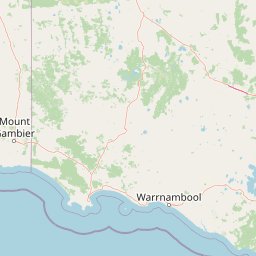
Map view of Budj Bim National Park

Use this park location map to pinpoint Budj Bim National Park in Australia, understand its exact geographic position, and read its mapped placement within the surrounding landscape more clearly.

Pigeon | © OpenStreetMap contributors
Park atlas

Compare adjacent protected landscapes and trace regional park geography in Victoria, Australia

Explore Nearby National Parks and Protected Areas Beyond Budj Bim National Park's Volcanic Landscape

Discover national parks and protected areas near Budj Bim National Park, allowing for geographic comparison of volcanic landscapes, World Heritage sites, and Aboriginal heritage in Victoria, Australia. Browse these adjacent conservation areas to understand the regional spread of protected lands and trace diverse ecological or cultural sites within their broader geographic context.
Protected areaVictoria
Mapped location lies within the park boundary#1 closest

East

Budj Bim heritage areas: Mapped Volcanic Landscapes and Ancient Aquaculture Systems

Regional protected geography in Victoria, Australia

Budj Bim heritage areas encompass a complex volcanic terrain in south-western Victoria, featuring extensive stone channel networks and managed wetland systems. This protected landscape documents thousands of years of Gunditjmara land engineering, from the dormant Budj Bim crater to the diverse marshlands of Tyrendarra. Access detailed map context and geographical data on this vital cultural and geological site.

Area
99.35 km²
IUCN
VI
Relief
Upland
Climate
Temperate
National parkAustralia
Mapped location lies within the park boundary#2 closest

Mount Eccles National Park: Geographic Atlas of Volcanic Protected Landscapes

Explore mapped boundaries and regional park geography.

Delve into the structured geographic information for Mount Eccles National Park, a significant protected area in Victoria, Australia. This component of Budj Bim National Park showcases a distinct volcanic landscape and its surrounding terrain. Understand the park's mapped boundaries, regional setting, and its place within Australia's diverse protected land atlas, offering a clear view of its natural geography.

Protected areaVictoria
About 24 km away#3 closest

Southeast

Deen Maar Indigenous Protected Area: Mapped Geography and Coastal Landscape Profile

Gunditjmara country coastal terrain in south west Victoria.

Situated between the Eumeralla River and Bass Strait, Deen Maar Indigenous Protected Area features an unusual concentration of habitats within a small footprint. From calcareous limestone ridges to shallow lake systems and shifting dunes, the reserve serves as a crucial bird conservation area while maintaining deep ties to Gunditjmara cultural identity and management practices.

Area
4.53 km²
Established
1999
IUCN
VI
Relief
Lowland
National parkBarwon South West
24 km away#4 closest

West

Cobboboonee National Park: A Protected Landscape in Australia's Barwon South West Region

Explore its mapped geography and natural terrain.

Cobboboonee National Park represents an important protected area within the Barwon South West region of Australia. This destination offers users a deep dive into the park's specific geography, providing context on its mapped boundaries and the surrounding natural landscapes. It is designed for exploration of the park's protected-area identity and its place within the regional geography, offering structured data for landscape context.

Area
185.1 km²
Established
2008
IUCN
II
Climate
Temperate
National parkAustralia
35 km away#5 closest

Southwest

Mount Richmond National Park: Protected Area Atlas and Southwest Victoria Landscape

Explore mapped terrain and coastal woodland ecosystems.

Mount Richmond National Park is a vital protected area in Victoria's southwest, safeguarding coastal woodland and heath remnants on the region's volcanic plains. As a component of Victoria's national park system, it provides a geographically specific example of a protected landscape, contributing to the regional atlas of natural environments. Its landscape character is defined by eucalyptus woodlands and coastal influences, offering context for understanding conservation corridors and the mapped natural terrain of the southwestern Victorian coast. The park’s inclusion in long-distance walking routes also underscores its value for exploring protected natural areas.

Area
17.33 km²
Established
1960
IUCN
II
Relief
Mixed relief
National parkAustralia
35 km away#6 closest

West

Lower Glenelg National Park: Dramatic River Gorge and Limestone Cave Protected Landscape

Explore its mapped boundaries and unique geological features.

Lower Glenelg National Park in Victoria, Australia, is a national park celebrated for its visually stunning Glenelg River gorge. This protected area showcases millions of years of geological history etched into its limestone cliffs and features the accessible Princess Margaret Rose Cave. Understand the park's mapped landscape, its diverse terrain from riverine woodlands to coastal wetlands, and its significance within regional geographic exploration.

Area
273 km²
Established
1969
IUCN
II
Visitors
200K annual
National parkAustralia
43 km away#7 closest

Southwest

Discovery Bay Marine National Park: Victoria's Protected Coastal Marine Landscape

Mapped protected waters adjacent to Cape Bridgewater's unique geography.

Discover the geographic scope and protected landscape identity of Discovery Bay Marine National Park, an important marine national park located in Victoria, Australia, near Portland. This protected area safeguards a crucial stretch of the country's southern coastline, contributing to the ecological significance of the Southern Ocean marine region. Its position adjacent to the Discovery Bay Coastal Park highlights an integrated conservation approach, offering users a detailed view of its mapped marine boundaries and the distinctive geological context of the Cape Bridgewater area for atlas exploration.

Area
27.7 km²
Established
2002
IUCN
II
Climate
Temperate
National parkAustralia
58 km away#8 closest

Northeast

Grampians National Park National Park: Sandstone Ranges and Aboriginal Heritage Atlas

Explore its mapped protected landscape and regional geography.

Grampians National Park stands as a testament to Victoria's natural and cultural heritage, featuring striking sandstone mountain ranges and an exceptional concentration of Aboriginal rock art sites. This protected area offers a deep dive into the region's unique geology, from its ancient sedimentary rock formations to its dramatic cliff faces and peaks. Understanding the park's mapped boundaries and its place within the broader geography provides essential context for appreciating its protected landscape identity and its millennia-long human history.

Area
1,672.19 km²
Established
1984
IUCN
II
Relief
Mountain

Common questions about visiting, size, designation, and location context for Budj Bim National Park

Budj Bim National Park FAQs for park facts, access, geography, and protected area context

Find quick answers about Budj Bim National Park, including protected-area facts, park geography, trail and visitor context, and how the park fits into its surrounding country and regional landscape.
MoriAtlas Explorer

Continue Your Protected Areas Search Across the Global Atlas

Deepen your exploration by continuing the structured search for national parks and protected areas worldwide. Utilize the comprehensive filtering capabilities to compare different conservation landscapes and refine your understanding of global park geography. Discover more about the distribution and characteristics of protected natural areas.

Global natural geography