

Mori Atlas logo
Marine protected areaTwelve Apostles Marine National Park

Mapping the iconic limestone formations and rich underwater geography of this Victorian marine protected area.

Twelve Apostles Marine National Park: A Protected Marine Landscape on Australia's South Coast

The Twelve Apostles Marine National Park in Victoria, Australia, offers a unique atlas exploration of a dramatic coastal protected landscape. This marine protected area encompasses the famed Twelve Apostles rock stacks, showcasing their monumental scale against the Southern Ocean. Delve into the mapped geography, from the towering surface formations to the complex underwater canyons and reef systems that define this significant marine environment.

Marine ParkCoastal Protected AreaLimestone FormationsShipwreck CoastRock StacksVictoria

Twelve Apostles Marine National Park

Marine protected area

Park overview

Structured park overview, official facts, and landscape profile for Twelve Apostles Marine National Park

Twelve Apostles Marine National Park park facts, protected area profile, and essential visitor context

Review the core facts for Twelve Apostles Marine National Park, including designation, size, terrain, visitor scale, habitats, and operating context in one park-focused overview.

About Twelve Apostles Marine National Park

Twelve Apostles Marine National Park represents one of Victoria's most significant coastal protected areas, combining dramatic above-water geology with remarkable underwater marine ecosystems. The park occupies a strategic position along the state's Shipwreck Coast, a stretch of shoreline notorious for its dangerous shoals and numerous shipwrecks throughout maritime history. The protected waters encompass a variety of marine habitats including subtidal rocky reefs, sandy bottoms, seagrass beds, and deepwater canyon systems that descend into the continental shelf waters of the Southern Ocean. The Twelve Apostles themselves, while visually commanding from the shoreline, represent only the visible portion of a larger limestone formation that extends beneath the waves. Below the surface, these rock foundations create critical habitat for marine life, providing attachment surfaces for algae, invertebrates, and fish species. The park's establishment in 2002 reflected growing recognition that effective coastal conservation required protecting not just terrestrial reserves but also the adjacent marine environments that support interconnected ecological communities.

Quick facts and research context for Twelve Apostles Marine National Park

This marine national park spans 75 square kilometres along Victoria's Shipwreck Coast, near the town of Port Campbell. It was officially established on 16 November 2002 and holds IUCN Category II protected area status. The park is named after the Twelve Apostles, a collection of limestone stacks that rise dramatically from the Southern Ocean. Within the park boundaries lies the historic wreck of the clipper Loch Ard, which ran aground on Mutton Bird Island in 1878. The marine park shares a boundary with Port Campbell National Park on land and extends the protected zone into the coastal waters of the Southern Ocean.

Protection and recognition

Analyzing official conservation frameworks and marine boundaries for critical offshore habitats

Twelve Apostles Marine National Park Protection Status and Marine Designation

Established legal protection frameworks secure the offshore environments of Twelve Apostles Marine National Park within regional marine networks. Verifying the official designation status and spatial protection scope helps researchers understand marine conservation efforts along the coastal margin.

Protection details

Protection scope
Marine
Transboundary protection
No
Park context

Deeper park guide and search-rich context for Twelve Apostles Marine National Park

Twelve Apostles Marine National Park history, landscape, wildlife, and travel context

Explore Twelve Apostles Marine National Park through its history, landscape character, ecosystems, wildlife, conservation priorities, cultural context, and seasonal travel timing in a structured park guide built for atlas discovery and search intent.

Why Twelve Apostles Marine National Park stands out

The Twelve Apostles Marine National Park is best known for protecting the iconic Twelve Apostles rock stacks, a collection of limestone pillars that rank among Victoria's most recognizable natural landmarks. These towering formations, carved by millennia of wave erosion, create a dramatic seascape where ancient rock meets the powerful Southern Ocean. Beyond the famous surface formations, the park is equally significant beneath the waves, protecting extensive rocky reef systems, underwater canyons, and diverse marine habitats that support a rich array of coastal and pelagic species. The park also preserves the maritime heritage of the region, including the wreck site of the Loch Ard clipper ship.

Twelve Apostles Marine National Park history and protected-area timeline

The Twelve Apostles Marine National Park was established on 16 November 2002 as part of Victoria's Marine National Park system. The creation of this protected area represented a significant expansion of marine conservation in the state, building upon the earlier designation of nearby Port Campbell National Park which protects the terrestrial portion of the coastline. The marine park designation came during a period of increased awareness about the need to protect Victoria's coastal and marine biodiversity, with the park joining a network of marine national parks established across the state's coastline. The naming of the park draws upon the established cultural significance of the Twelve Apostles rock stacks, which had already become one of Victoria's most visited coastal attractions through their protection within the adjoining Port Campbell National Park. The preservation of the Loch Ard wreck site within the marine park reflects the region's rich maritime heritage, with the clipper ship having met its end on Mutton Bird Island in 1878 during a voyage from England to Melbourne.

Twelve Apostles Marine National Park landscape and geographic character

The landscape of Twelve Apostles Marine National Park is defined by the dramatic collision between ancient limestone formations and the relentless power of the Southern Ocean. The Twelve Apostles rock stacks, rising up to 70 metres from sea level, represent the remnants of a oncecontinuous limestone cliff that has been progressively eroded by wave action over millions of years. These monolithic pillars, with their weathered surfaces and angular profiles, create one of Australia's most photographed coastal scenes. Below the waterline, the limestone geology continues to shape the underwater terrain, with rocky reefs, boulders, and submerged cliffs forming a complex bathymetry that ranges from shallow nearshore areas to deeper waters further offshore. The combination of strong currents, clear waters, and diverse bottom substrates creates conditions that support both attached marine organisms and free-swimming species throughout the water column.

Twelve Apostles Marine National Park ecosystems, habitats, and plant life

The marine park protects a rich variety of coastal and marine ecosystems that reflect the transitional nature of this part of Victoria's coastline. Rocky reef communities dominate the hard substrate areas, supporting dense growths of brown algae, red coralline algae, and various sessile invertebrates. These reef systems provide crucial habitat for numerous fish species, including common coastal taxa as well as more specialist species associated with temperate Australian waters. Seagrass beds occur in shallower protected areas, particularly in bays and coves along the coastline, providing important habitat for invertebrates and fish while also contributing to water quality through their nutrient cycling and sediment stabilization functions. The open waters of the park support pelagic species including various fish, seabirds, and marine mammals that forage in the productive coastal zone.

Twelve Apostles Marine National Park wildlife and species highlights

The wildlife of Twelve Apostles Marine National Park includes both the prominent seabirds that frequent the coastline and the diverse marine species inhabiting the waters below. The rock stacks and islands within and adjacent to the park provide nesting habitat for seabirds including various gull and tern species, while the surrounding waters support foraging seabirds such as albatrosses and petrels that range across the Southern Ocean. The underwater communities host numerous fish species that utilize the reef structures for shelter and feeding, with common representatives including members of the odacidae and labridae families that are characteristic of temperate Australian reefs. Marine mammals, including seals and occasional dolphin sightings, utilize the waters of the park as part of their broader coastal movements.

Twelve Apostles Marine National Park conservation status and protection priorities

The Twelve Apostles Marine National Park plays an important role in Victoria's marine protected area network, providing permanent protection for a representative sample of the state's coastal marine environments. The park's designation ensures that the geological and ecological values of this iconic coastline are maintained for future generations, preventing activities that could degrade the marine ecosystems or damage the significant underwater heritage sites. The protection of the underwater reef systems helps preserve biodiversity and supports ecosystem processes that would be vulnerable to disturbance in an unprotected area. The marine park also contributes to broader conservation objectives by connecting with adjacent terrestrial parks to create a coastal conservation corridor that spans from the shoreline into the offshore waters.

Twelve Apostles Marine National Park cultural meaning and human context

The cultural context of Twelve Apostles Marine National Park extends beyond its natural values to include the maritime heritage of Victoria's Shipwreck Coast. The wreck of the clipper Loch Ard, which foundered on Mutton Bird Island in 1878, represents one of the region's most historically significant shipwrecks and is preserved within the marine park boundaries. This tragedy, which claimed the lives of most aboard the vessel, has become part of the regional narrative and contributes to the area's sense of place. The Twelve Apostles themselves hold cultural significance as landmark features that have orientated sailors and travellers along this dangerous coast for generations. The adjacent Indigenous heritage of the region, while not extensively documented in the available source material, is associated with the traditional lands of Aboriginal peoples who have long inhabited the Victorian coastline.

Top sights and standout views in Twelve Apostles Marine National Park

The Twelve Apostles Marine National Park offers visitors the chance to experience both the iconic above-water scenery of the limestone stacks and the rich underwater environments that lie beneath the surface. The park provides opportunities for scenic appreciation from the adjacent Port Campbell National Park, where viewing platforms offer panoramas of the rock stacks rising from the sea. The marine environment within the park supports diving and snorkelling activities that allow visitors to explore the underwater reef systems and observe the marine life that inhabits these protected waters. The historical significance of the Loch Ard wreck adds another dimension to the park, connecting visitors to the maritime heritage that has shaped this coastline.

Best time to visit Twelve Apostles Marine National Park

The twelve apostles marine national park can be visited throughout the year, with each season offering different experiences. The summer months of December through February typically bring warmer air temperatures and longer daylight hours, making it comfortable for coastal walking and landscape photography. Winter months, while cooler, often produce dramatic storm sequences that showcase the raw power of the Southern Ocean crashing against the rock stacks. The underwater visibility for diving and snorkelling tends to be best during the calmer summer and early autumn months when sea conditions are more stable. Wildlife viewing opportunities remain available year-round, though the presence of migratory seabirds and marine mammals may vary seasonally.
Monthly climate preview

Long-term temperature averages and monthly precipitation patterns across decades

Twelve Apostles Marine National Park Climate and Monthly Weather Normals

Long-term climatology from a representative marine coordinate reveals a temperate cycle where average mean temperatures range from under ten degrees Celsius in July to over eighteen degrees Celsius in February. Accessing the complete twelve-month profile clarifies historical weather-by-month averages and seasonal precipitation shifts to support precise geographic comparison.
Annual mean14 °C
10 °C18 °C
Jan18°
Feb18°
Mar17°
Apr14°
May12°
Jun10°
Jul10°
Aug10°
Sep11°
Oct13°
Nov15°
Dec16°
Warmest month
February

18.3 °C

Coolest month
July

9.7 °C

Wettest month
August

3.2 mm/day

Driest month
February

1.4 mm/day

Park location guide

Geography guide, regional context, and park location map for Twelve Apostles Marine National Park

Twelve Apostles Marine National Park park geography, regions, and map view in Australia

Understand where Twelve Apostles Marine National Park sits in Australia through a broader geographic reading of the surrounding landscape, nearby location context, and its mapped position within the national park landscape.

How Twelve Apostles Marine National Park fits into Australia

Australia is a constitutional monarchy and federal parliamentary democracy comprising six states and ten territories. With a population of nearly 28 million, it is one of the world's most urbanised countries, with most people concentrated on the eastern seaboard. The country has a high Human Development Index and is known for its cultural diversity, ancient Aboriginal heritage, and unique wildlife.

Wider geography shaping Twelve Apostles Marine National Park in Australia

Australia occupies the entire Australian continent, the island of Tasmania, and numerous smaller islands. It is the world's flattest and driest inhabited continent, featuring vast deserts in the interior (the Outback), tropical rainforests along the eastern coast, and a coastline bordering the Indian and Pacific Oceans.

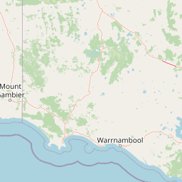
Map view of Twelve Apostles Marine National Park

Use this park location map to pinpoint Twelve Apostles Marine National Park in Australia, understand its exact geographic position, and read its mapped placement within the surrounding landscape more clearly.

Pigeon | © OpenStreetMap contributors
Recorded earthquake history

Explore Historical Earthquake Records for Twelve Apostles Marine National Park

Review the documented history of seismic events occurring near the coastal and marine geography of Twelve Apostles Marine National Park. MoriAtlas provides a clear, structured catalog of recorded earthquake data to assist with understanding the seismic context of this protected Australian coastal environment.

Twelve Apostles Marine National Park Earthquake History

Catalogued events

4 events

Strongest magnitude

Magnitude 4.8

Most recent event

Jul 5, 2026

This history includes earthquakes recorded inside the park or within 50 km of its borders

Park atlas

Compare adjacent national parks and trace interconnected protected landscapes across Victoria's dramatic coastlines.

Discover Other National Parks and Protected Areas Beyond Twelve Apostles Marine National Park

Browse additional national parks and protected areas along Victoria's iconic Shipwreck Coast, extending your discovery beyond the specific marine and limestone formations of Twelve Apostles Marine National Park. Comparing these diverse conservation landscapes provides valuable geographic context for understanding the region's interconnected ecosystems and varied coastal terrain.
National parkAustralia
Park boundaries overlap#1 closest

East

Great Otway National Park: Discover Its Mapped Boundaries and Unique Temperate Rainforest Geography

Explore the diverse terrain and protected landscape of Victoria's coastal ranges.

Great Otway National Park represents a vital protected natural area, distinguished by its dramatic confluence of coastal features and lush inland temperate rainforests. Situated within the Otway Ranges, the park's mapped landscape includes rugged coastlines, V-shaped valleys, and numerous waterfalls that cascade through ancient fern gullies. Understanding the park's geographic setting and protected area status is central to appreciating its ecological significance and its place within the broader Australian conservation landscape. This detailed view allows for in-depth exploration of its unique terrain and protected natural resources.

Area
1,032 km²
Established
2005
IUCN
II
Relief
Mountain
National parkAustralia
Park boundaries overlap#2 closest

Northwest

Port Campbell National Park: Iconic Limestone Cliffs and Coastal Protected Area

Explore the mapped geography of Victoria's dramatic Shipwreck Coast.

Port Campbell National Park, a prominent national park in Victoria, Australia, offers an unparalleled atlas exploration of coastal geology. Its landscape is defined by towering limestone cliffs, iconic offshore rock stacks such as the Twelve Apostles, and numerous natural arches and blowholes sculpted by the Southern Ocean. This protected area provides critical geographic context for the Shipwreck Coast's dramatic terrain and serves as a focal point for understanding Australia's dynamic natural heritage.

Area
17.5 km²
Established
1964
IUCN
II
Visitors
2M annual
Marine protected areaVictoria
34 km away#3 closest

Southeast

Apollo Marine Park: A Submarine Atlas of the Bass Strait Basin and Otway Depression

Examining underwater topography and maritime heritage off Victoria

Apollo Marine Park represents a critical offshore protected area, spanning over 1,180 square kilometres of seabed. Its primary feature, the Otway Depression, offers a window into ice age geology through drowned river valleys and fossil drainage channels that once defined the Bassian Plain. The reserve functions as an underwater archive of southeastern Australian environmental history, integrating deep-time geomorphology with significant twentieth-century maritime shipwreck remnants.

Area
1,184 km²
Established
2007
IUCN
VI
Relief
Lowland
Protected areaVictoria
About 55 km away#4 closest

Northwest

Framlingham Forest Indigenous Protected Area: Geography and Landscape Overview

Aboriginal-owned savanna woodlands in Western Victoria

Framlingham Forest Indigenous Protected Area is an important cultural and ecological site in south-western Victoria. Spanning over 1,100 hectares of stringybark and manna gum savannah, this protected area offers a unique glimpse into the native woodland ecosystems that once defined the Western District plains near the Hopkins River.

Area
11.3 km²
Established
2009
Relief
Lowland
Scope
Terrestrial
Protected areaVictoria
About 95 km away#5 closest

West

Deen Maar Indigenous Protected Area: Mapped Geography and Coastal Landscape Profile

Gunditjmara country coastal terrain in south west Victoria.

Situated between the Eumeralla River and Bass Strait, Deen Maar Indigenous Protected Area features an unusual concentration of habitats within a small footprint. From calcareous limestone ridges to shallow lake systems and shifting dunes, the reserve serves as a crucial bird conservation area while maintaining deep ties to Gunditjmara cultural identity and management practices.

Area
4.53 km²
Established
1999
IUCN
VI
Relief
Lowland
National parkAustralia
About 98 km away#6 closest

East

Point Addis Marine National Park: Victoria's Protected Coastal Atlas

Mapped marine park and coastal landscape context.

Point Addis Marine National Park is a significant protected marine area situated along the renowned Surf Coast of Victoria, Australia. This park safeguards the coastal waters and shoreline around iconic locations like Bells Beach, preserving vital marine habitats including extensive rocky reefs and kelp forests. Its geography is defined by dramatic sandstone cliffs and the influence of the Southern Ocean, making it a crucial site for understanding temperate marine ecosystems within a popular recreational region. Discover its mapped boundaries and ecological significance for regional geography.

Area
46 km²
Established
2002
IUCN
II
Climate
Temperate
National parkAustralia
112 km away#7 closest

Northwest

Budj Bim National Park: Ancient Volcanic Landscapes and World Heritage Protected Area

Explore the unique geography of Budj Bim National Park's crater lakes and lava tubes.

Budj Bim National Park offers an exceptional exploration of volcanic geography and ancient human ingenuity. This protected area features a dramatic landscape dominated by volcanic cones, lava tubes, and the picturesque Lake Surprise crater lake. Its significance is amplified by the presence of sophisticated Aboriginal aquaculture systems, developed thousands of years ago by the Gunditjmara people, which have contributed to its UNESCO World Heritage status. Discover the mapped terrain and protected land context of this geologically and culturally rich Australian national park.

Area
54.7 km²
Established
1960
IUCN
II
Relief
Mixed relief
Marine protected areaTasmania
114 km away#8 closest

South

Zeehan Commonwealth Marine Reserve: Geographic Map and Protected Marine Landscape Overview

Deep-sea habitats and shelf bathymetry off the Tasmanian coast

Spanning from fifty meters to over three thousand meters deep, the Zeehan Commonwealth Marine Reserve represents a massive, bathymetrically diverse protected area in the southern Indian Ocean. This geographic overview highlights the reserve's role in conserving limestone seabed features and deep-sea corridors west of Tasmania, offering a clear perspective on its location and scale within the broader regional marine network.

Area
19,897 km²
Established
2007
IUCN
VI
Relief
Lowland

Common questions about visiting, size, designation, and location context for Twelve Apostles Marine National Park

Twelve Apostles Marine National Park FAQs for park facts, access, geography, and protected area context

Find quick answers about Twelve Apostles Marine National Park, including protected-area facts, park geography, trail and visitor context, and how the park fits into its surrounding country and regional landscape.
MoriAtlas Explorer

Continue Your Protected Areas Search Across the Global Atlas

Deepen your exploration by continuing the structured search for national parks and protected areas worldwide. Utilize the comprehensive filtering capabilities to compare different conservation landscapes and refine your understanding of global park geography. Discover more about the distribution and characteristics of protected natural areas.

Global natural geography