

Mori Atlas logo
Protected areaFramlingham Forest Indigenous Protected Area

A significant Aboriginal-owned protected landscape and riverine forest in Western Victoria

Framlingham Forest Indigenous Protected Area: Mapping the Savannah Woodlands of Victoria

Framlingham Forest Indigenous Protected Area represents a vital 1,130-hectare remnant of stringybark and manna gum savannah woodland situated near the Hopkins River in Western Victoria. This protected landscape provides essential context for understanding the intersection of Aboriginal land rights and regional biodiversity conservation. The area serves as a critical biological refuge within the broader agricultural plains, tracing a history that links ancestral cultural grounds with modern environmental stewardship.

Indigenous Protected AreaAboriginal-owned landstringybark forestmanna gum woodlandsavannah woodlandWestern District Victoria

Framlingham Forest Indigenous Protected Area

Protected area

Park overview

Structured park overview, official facts, and landscape profile for Framlingham Forest Indigenous Protected Area

Framlingham Forest Indigenous Protected Area park facts, protected area profile, and essential visitor context

Review the core facts for Framlingham Forest Indigenous Protected Area, including designation, size, terrain, visitor scale, habitats, and operating context in one park-focused overview.

About Framlingham Forest Indigenous Protected Area

Framlingham Forest Indigenous Protected Area sits in the Hopkins River catchment of western Victoria, in a landscape historically dominated by grassy woodland and savannah that has been heavily cleared for dairy and sheep grazing since the 1840s. The IPA itself extends across roughly 1,130 hectares of native forest, and within the broader Western District it is regarded as the most significant surviving example of its ecological type.

Ecologically, the forest is characterised by an open savannah structure in which mature stringybark and manna gum eucalypts rise above a grassy understorey. This vegetation pattern once shaped much of the inland south-west Victorian countryside, but extensive clearing for agriculture has left only scattered remnants, of which Framlingham is the largest. The IPA therefore functions both as a refuge for native flora and fauna and as a reference site for the original character of the region's woodlands.

Culturally and historically, the IPA is inseparable from the older Framlingham Aboriginal Reserve, established in 1861 after the Church of England's Warrnambool diocese acquired land for an Anglican mission to address the dispossession of local Aboriginal people. Survivors of the Kirrae Wuurong clans, along with Djargurd Wurrung from the Camperdown area and Gunditjmara from Warrnambool, were relocated there from 1865 onwards. The reserve was repeatedly threatened with closure, its land was cut back in the 1890s, and a substantial portion was excised to become what is now Framlingham State Forest.

The forest's modern status grew out of a sustained Aboriginal land-rights campaign. After Aboriginal ownership of the remaining reserve was granted to the Framlingham Aboriginal Trust in 1971, community members blockaded the forest in 1979, refused a Victorian Government proposal that would have left the land as crown land under Aboriginal management, and ultimately secured a Commonwealth transfer of 1,130 acres under the Aboriginal Land (Lake Condah and Framlingham Forest) Act 1987. The IPA designation in 2009 formalised Aboriginal-led conservation management of the returned land through the Kirrae Whurrong Aboriginal Corporation.

Quick facts and research context for Framlingham Forest Indigenous Protected Area

Framlingham Forest IPA is situated in the Western District of Victoria, between the Hopkins River and the historic township of Framlingham, roughly 20 kilometres north-east of Warrnambool. The protected area covers about 1,130 hectares of native forest and represents the largest remaining stringybark and manna gum savannah remnant in the district.

The forest was returned to Aboriginal ownership through the Commonwealth Aboriginal Land (Lake Condah and Framlingham Forest) Act 1987, after years of community blockades and negotiations. In 2009 it was formally declared an Indigenous Protected Area, with the Kirrae Whurrong Aboriginal Corporation and Framlingham Aboriginal Trust acting as landholders. The site lies within the formally recognised traditional-owner area of the Eastern Maar peoples.

Protection and recognition

Documented terrestrial protection scope, designation year, and management framework

Framlingham Forest Indigenous Protected Area Protection Status and Designation History

Framlingham Forest Indigenous Protected Area maintains a documented terrestrial protection scope established in the designation year 2009. Official records outline the conservation framework, management boundaries, and associated protected area status details.

Protection details

Protection scope
Terrestrial
Designated year
2009
Transboundary protection
No
Park context

Deeper park guide and search-rich context for Framlingham Forest Indigenous Protected Area

Framlingham Forest Indigenous Protected Area history, landscape, wildlife, and travel context

Explore Framlingham Forest Indigenous Protected Area through its history, landscape character, ecosystems, wildlife, conservation priorities, cultural context, and seasonal travel timing in a structured park guide built for atlas discovery and search intent.

Why Framlingham Forest Indigenous Protected Area stands out

Framlingham Forest IPA is best known for being the largest surviving remnant of stringybark and manna gum savannah woodland in its part of western Victoria, an ecological feature that has largely disappeared from the surrounding agricultural landscape. It is equally known as a landmark in Australian Aboriginal land rights, having been returned to traditional owners through 1987 Commonwealth legislation after a community blockade in 1979 and a long political struggle. The protected area is also recognised for its layered cultural significance: it was carved out of the historical Framlingham Aboriginal Reserve, established in 1861, and remains a homeland and ceremonial country for the Kirrae Wuurong, Djargurd Wurrung and Gunditjmara descendants associated with the reserve. Together, these ecological and historical qualities make the IPA an unusually vivid example of conservation being driven by Aboriginal ownership rather than imposed on it.

Framlingham Forest Indigenous Protected Area history and protected-area timeline

The history of Framlingham Forest IPA is bound up with the long and contested history of the Framlingham Aboriginal Reserve. European settlement in the Hopkins River valley began around 1840, with the Brefnay Hotel, a store and a Presbyterian church established over the following decades. The area was rapidly cleared for dairy farming and grazing, displacing and reshaping the landscape that had supported Kirrae Wuurong life for many generations.

In 1861 the Church of England in Warrnambool obtained some 1,416 hectares of land for an Aboriginal mission, and the Victorian Board for the Protection of Aborigines formally established the Framlingham Aboriginal Reserve in response. From 1865, surviving Kirrae Wuurong people, along with some Djargurd Wurrung and Gunditjmara families, were settled on the reserve beside the Hopkins River. Despite repeated attempts by the Board and local residents to close or shrink the reserve, the Kirrae Wuurong successfully resisted relocation in 1868 and the community remained.

In the 1890s the reserve was reduced to a small fraction of its original size, and most of the excised land was reallocated as State Forest, now known as Framlingham State Forest. The reserve itself continued under Aboriginal occupation until 1916, when the Victorian Government attempted to concentrate Aboriginal Victorians at the Lake Tyers Mission in Gippsland. Some residents were permitted to remain, and from the 1930s public concern about their conditions prompted the construction of additional housing, a school and improved provisions from the government.

The modern era of land rights began with the abolition of the Board for the Protection of Aborigines in 1957 and the passage of Victoria's Aboriginal Lands Act 1970. On 1 July 1971 ownership of the residual reserve was transferred to the Framlingham Aboriginal Trust, making Framlingham one of the last Aboriginal reserves to close in Victoria. In 1976 the community launched a campaign to recover the forest that had been excised in the 1890s, and in April 1979 community members blockaded the road to the forest's picnic ground. The Victorian Government's compromise offer of Aboriginal management over continued crown land was rejected, and the blockade resumed.

In 1987 the Commonwealth Parliament passed the Aboriginal Land (Lake Condah and Framlingham Forest) Act 1987, returning 1,130 acres of the Framlingham State Forest to the Aboriginal trust on essentially inalienable title. In 2009 this returned forest was formally dedicated as an Indigenous Protected Area, consolidating Aboriginal ownership and conservation management under what is now the Kirrae Whurrong Aboriginal Corporation.

Framlingham Forest Indigenous Protected Area landscape and geographic character

The IPA lies on the inland side of Victoria's south-west coast, in the gently undulating country between the Hopkins River and the small township of Framlingham. The river corridor itself runs through parts of the landscape, with alluvial flats and low rises giving way to the broader plains of the Western District that sweep west to Warrnambool and the Southern Ocean.

Within this cleared agricultural setting, the IPA forms a distinct block of native bushland, an irregular patch of open woodland rising out of surrounding pasture. Its terrain is undulating rather than steep, more typical of inland western Victoria than of the rugged coast further south. Grassy tracks, former logging-era roads and the Hopkins River corridor shape the visual texture of the protected area.

Framlingham Forest Indigenous Protected Area ecosystems, habitats, and plant life

The dominant vegetation of Framlingham Forest IPA is an open eucalypt savannah, in which widely spaced mature stringybark trees and manna gum eucalypts stand above a native grass and herb understorey. This savannah structure once characterised much of the inland Hopkins River country, but extensive clearing for dairy and sheep farming during the nineteenth and twentieth centuries reduced such woodland to small, scattered remnants. The IPA is therefore ecologically significant not only for what it contains but for what it represents of a largely vanished regional vegetation type.

The protection of this woodland mosaic supports the habitat requirements of a wide range of native birds, mammals, reptiles and insects that depend on mature hollow-bearing eucalypts and intact grassy understorey. The IPA's conservation management, guided by Aboriginal traditional owners, is framed around maintaining this open savannah character rather than allowing it to thicken into closed forest or be further reduced by clearing or grazing pressure.

Framlingham Forest Indigenous Protected Area wildlife and species highlights

As a substantial remnant of stringybark and manna gum savannah in an otherwise heavily cleared district, the IPA provides habitat for the typical suite of south-west Victorian woodland species. Mature hollow-bearing eucalypts within the forest support parrots, cockatoos and other cavity-nesting birds, while the grassy understorey provides foraging and shelter for small ground-dwelling mammals, reptiles and invertebrates. The protected area is therefore of regional importance for the persistence of woodland-dependent fauna in an agricultural matrix where such habitat is otherwise scarce.

Framlingham Forest Indigenous Protected Area conservation status and protection priorities

Framlingham Forest IPA is the largest surviving remnant of its native forest type in the surrounding Western District, giving it strong conservation value simply by virtue of its size and condition in a largely cleared landscape. The IPA designation, conferred in 2009, formalises long-term protection of the forest under Aboriginal-led management and places it within Australia's national network of Indigenous Protected Areas, which are recognised as a significant component of the country's conservation estate.

The IPA's conservation importance is sharpened by its origin: the forest was returned to Aboriginal ownership through the 1987 Commonwealth land legislation, and its ongoing protection is administered by the Kirrae Whurrong Aboriginal Corporation rather than by a government agency. This makes the IPA a notable example of conservation outcomes being achieved through Indigenous land ownership and traditional ecological knowledge, anchored in the cultural obligation of traditional owners to care for country.

Framlingham Forest Indigenous Protected Area cultural meaning and human context

The IPA is inseparable from the cultural history of the Kirrae Wuurong people and the wider Aboriginal community of the Framlingham reserve. The reserve was established in 1861 in response to Anglican and government concern about the conditions of Aboriginal people displaced by pastoral and agricultural settlement, and from 1865 it became home to surviving members of the Kirrae Wuurong clans, along with Djargurd Wurrung and Gunditjmara families. Among those associated with the reserve were the Kirrae Wuurong leader Kaawirn Kuunawarn (King David), who lived at Framlingham from 1865 until 1889, and later residents such as Collin and Nora Hood and singer-songwriter Archie Roach in his early childhood.

The decades-long struggle to recover the excised forest, including the 1979 road blockade and the community's rejection of half-measures, makes the IPA a landmark in Victorian Aboriginal land rights. Today the formally recognised traditional owners of the broader area are groups within the Eastern Maar peoples, represented by the Eastern Maar Aboriginal Corporation, and the IPA is governed through the Kirrae Whurrong Aboriginal Corporation and Framlingham Aboriginal Trust as a continuing expression of Aboriginal custodianship of country.

Top sights and standout views in Framlingham Forest Indigenous Protected Area

At roughly 1,130 hectares, Framlingham Forest IPA is the largest surviving remnant of stringybark and manna gum savannah in its part of western Victoria, standing out as a major patch of native bush in a largely cleared pastoral landscape. It is simultaneously one of Australia's more prominent examples of an Indigenous Protected Area arising directly from a land-rights campaign, with the 1987 Commonwealth return of the forest and the 2009 IPA dedication marking two key milestones.

The forest's layered identity, Aboriginal reserve, mission, state forest, returned Aboriginal land and now IPA, makes it unusually rich in both ecological and cultural meaning, and a reference point for understanding how Aboriginal ownership and conservation can be pursued together rather than as separate agendas.

Best time to visit Framlingham Forest Indigenous Protected Area

Framlingham Forest sits in a temperate part of south-western Victoria, where autumn, winter and spring generally bring cooler temperatures, regular rainfall and greener understorey conditions, while summer can be warm and dry with elevated bushfire risk, as demonstrated by the 1983 Ash Wednesday fires that began near the forest. Visits during the cooler and wetter months typically offer more comfortable walking conditions and a more vivid display of native grasses and wildflowers in the savannah understorey, though the woodland character of the forest itself remains constant throughout the year. Given the protected area's cultural significance, visitors are encouraged to approach it respectfully and to follow guidance from the managing Aboriginal organisations regarding access and appropriate behaviour on country.
Monthly climate preview

Long-term temperature ranges and monthly precipitation averages for Victoria

Framlingham Forest Indigenous Protected Area Climate and Annual Weather Patterns

Representative coordinates record measured multi-year shifts in monthly temperature and daily precipitation across the protected area. Examining the complete twelve-month climatology reveals detailed annual variations in regional weather normals.
Annual mean13 °C
8 °C19 °C
Jan19°
Feb19°
Mar17°
Apr14°
May11°
Jun
Jul
Aug
Sep10°
Oct12°
Nov15°
Dec17°
Warmest month
February

19.1 °C

Coolest month
July

8.1 °C

Wettest month
August

2.6 mm/day

Driest month
February

1.1 mm/day

Park location guide

Geography guide, regional context, and park location map for Framlingham Forest Indigenous Protected Area

Framlingham Forest Indigenous Protected Area park geography, regions, and map view in Australia

Understand where Framlingham Forest Indigenous Protected Area sits in Australia through a broader geographic reading of the surrounding landscape, nearby location context, and its mapped position within the national park landscape.

How Framlingham Forest Indigenous Protected Area fits into Australia

Australia is a constitutional monarchy and federal parliamentary democracy comprising six states and ten territories. With a population of nearly 28 million, it is one of the world's most urbanised countries, with most people concentrated on the eastern seaboard. The country has a high Human Development Index and is known for its cultural diversity, ancient Aboriginal heritage, and unique wildlife.

Wider geography shaping Framlingham Forest Indigenous Protected Area in Australia

Australia occupies the entire Australian continent, the island of Tasmania, and numerous smaller islands. It is the world's flattest and driest inhabited continent, featuring vast deserts in the interior (the Outback), tropical rainforests along the eastern coast, and a coastline bordering the Indian and Pacific Oceans.

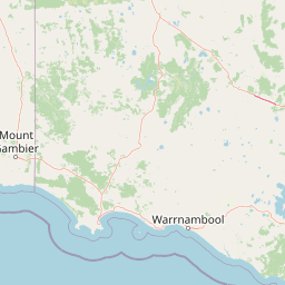
Map view of Framlingham Forest Indigenous Protected Area

Use this park location map to pinpoint Framlingham Forest Indigenous Protected Area in Australia, understand its exact geographic position, and read its mapped placement within the surrounding landscape more clearly.

Pigeon | © OpenStreetMap contributors

Location context for Framlingham Forest Indigenous Protected Area

Victoria
Park atlas

Compare regional reserves, savannah woodlands, and adjacent conservation areas across Western Victoria

Explore Parks Near Framlingham Forest Indigenous Protected Area and Surrounding Protected Landscapes

Browsing other protected areas near Framlingham Forest Indigenous Protected Area reveals connected ecological corridors and diverse regional park geography. Examining these adjacent reserves provides valuable context on the broader natural landscapes and savannah woodlands of south-western Victoria.
National parkAustralia
About 44 km away#1 closest

Southeast

Port Campbell National Park: Iconic Limestone Cliffs and Coastal Protected Area

Explore the mapped geography of Victoria's dramatic Shipwreck Coast.

Port Campbell National Park, a prominent national park in Victoria, Australia, offers an unparalleled atlas exploration of coastal geology. Its landscape is defined by towering limestone cliffs, iconic offshore rock stacks such as the Twelve Apostles, and numerous natural arches and blowholes sculpted by the Southern Ocean. This protected area provides critical geographic context for the Shipwreck Coast's dramatic terrain and serves as a focal point for understanding Australia's dynamic natural heritage.

Area
17.5 km²
Established
1964
IUCN
II
Visitors
2M annual
Marine protected areaAustralia
About 55 km away#2 closest

Southeast

Twelve Apostles Marine National Park: Protected Landscape and Marine Atlas Exploration

Mapping iconic rock stacks and underwater reef geography.

Twelve Apostles Marine National Park, located on Victoria's south coast, is a key marine protected area renowned for its striking limestone rock stacks and the diverse underwater ecosystems they shelter. This park offers a unique opportunity for atlas exploration, detailing the mapped boundaries and the fascinating marine geography from cliff faces to submerged reefs. Understand the protected landscape and its integral role within Australia's coastal conservation network.

Area
75 km²
Established
2002
IUCN
II
Climate
Temperate
National parkAustralia
About 59 km away#3 closest

Southeast

Great Otway National Park: Discover Its Mapped Boundaries and Unique Temperate Rainforest Geography

Explore the diverse terrain and protected landscape of Victoria's coastal ranges.

Great Otway National Park represents a vital protected natural area, distinguished by its dramatic confluence of coastal features and lush inland temperate rainforests. Situated within the Otway Ranges, the park's mapped landscape includes rugged coastlines, V-shaped valleys, and numerous waterfalls that cascade through ancient fern gullies. Understanding the park's geographic setting and protected area status is central to appreciating its ecological significance and its place within the broader Australian conservation landscape. This detailed view allows for in-depth exploration of its unique terrain and protected natural resources.

Area
1,032 km²
Established
2005
IUCN
II
Relief
Mountain
Protected areaVictoria
About 59 km away#4 closest

West

Deen Maar Indigenous Protected Area: Mapped Geography and Coastal Landscape Profile

Gunditjmara country coastal terrain in south west Victoria.

Situated between the Eumeralla River and Bass Strait, Deen Maar Indigenous Protected Area features an unusual concentration of habitats within a small footprint. From calcareous limestone ridges to shallow lake systems and shifting dunes, the reserve serves as a crucial bird conservation area while maintaining deep ties to Gunditjmara cultural identity and management practices.

Area
4.53 km²
Established
1999
IUCN
VI
Relief
Lowland
National parkAustralia
About 66 km away#5 closest

West

Budj Bim National Park: Ancient Volcanic Landscapes and World Heritage Protected Area

Explore the unique geography of Budj Bim National Park's crater lakes and lava tubes.

Budj Bim National Park offers an exceptional exploration of volcanic geography and ancient human ingenuity. This protected area features a dramatic landscape dominated by volcanic cones, lava tubes, and the picturesque Lake Surprise crater lake. Its significance is amplified by the presence of sophisticated Aboriginal aquaculture systems, developed thousands of years ago by the Gunditjmara people, which have contributed to its UNESCO World Heritage status. Discover the mapped terrain and protected land context of this geologically and culturally rich Australian national park.

Area
54.7 km²
Established
1960
IUCN
II
Relief
Mixed relief
A watercolor painting of a calm body of water bordered by gentle rolling green hills and sparse trees under a soft, light-filled sky.
Protected areaVictoria
About 72 km away#6 closest

West

Budj Bim heritage areas: Mapped Volcanic Landscapes and Ancient Aquaculture Systems

Regional protected geography in Victoria, Australia

Budj Bim heritage areas encompass a complex volcanic terrain in south-western Victoria, featuring extensive stone channel networks and managed wetland systems. This protected landscape documents thousands of years of Gunditjmara land engineering, from the dormant Budj Bim crater to the diverse marshlands of Tyrendarra. Access detailed map context and geographical data on this vital cultural and geological site.

Area
99.35 km²
IUCN
VI
Relief
Upland
Climate
Temperate
National parkAustralia
About 74 km away#7 closest

West

Mount Eccles National Park: Geographic Atlas of Volcanic Protected Landscapes

Explore mapped boundaries and regional park geography.

Delve into the structured geographic information for Mount Eccles National Park, a significant protected area in Victoria, Australia. This component of Budj Bim National Park showcases a distinct volcanic landscape and its surrounding terrain. Understand the park's mapped boundaries, regional setting, and its place within Australia's diverse protected land atlas, offering a clear view of its natural geography.

National parkAustralia
About 74 km away#8 closest

North

Grampians National Park National Park: Sandstone Ranges and Aboriginal Heritage Atlas

Explore its mapped protected landscape and regional geography.

Grampians National Park stands as a testament to Victoria's natural and cultural heritage, featuring striking sandstone mountain ranges and an exceptional concentration of Aboriginal rock art sites. This protected area offers a deep dive into the region's unique geology, from its ancient sedimentary rock formations to its dramatic cliff faces and peaks. Understanding the park's mapped boundaries and its place within the broader geography provides essential context for appreciating its protected landscape identity and its millennia-long human history.

Area
1,672.19 km²
Established
1984
IUCN
II
Relief
Mountain

Common questions about visiting, size, designation, and location context for Framlingham Forest Indigenous Protected Area

Framlingham Forest Indigenous Protected Area FAQs for park facts, access, geography, and protected area context

Find quick answers about Framlingham Forest Indigenous Protected Area, including protected-area facts, park geography, trail and visitor context, and how the park fits into its surrounding country and regional landscape.
MoriAtlas Explorer

Continue Your Protected Areas Search Across the Global Atlas

Deepen your exploration by continuing the structured search for national parks and protected areas worldwide. Utilize the comprehensive filtering capabilities to compare different conservation landscapes and refine your understanding of global park geography. Discover more about the distribution and characteristics of protected natural areas.

Global natural geography