Mori Atlas logo
National parkWyperfeld National Park

Map the unique sandhill formations and ephemeral lake systems of this vast semi-arid wilderness.

Wyperfeld National Park: Exploring Victoria's Expansive Mallee Protected Landscape and Geography

Wyperfeld National Park represents a substantial protected landscape within Victoria, Australia's north-western Mallee district. This national park offers an unparalleled opportunity to explore a unique semi-arid environment characterized by extensive sand dunes, known as 'snowdrifts,' and an intermittent ephemeral lake system. Its vast expanse protects one of Australia's most significant mallee ecosystems, providing crucial habitat within a regional network of conservation lands and offering a distinct geographic perspective for atlas-based discovery.

mallee ecosystemsemi-arid wildernessVictoria national parksephemeral lakesImportant Bird Areasandhill landscapes

Wyperfeld National Park

National park

Park overview

Structured park overview, official facts, and landscape profile for Wyperfeld National Park

Wyperfeld National Park park facts, protected area profile, and essential visitor context
Review the core facts for Wyperfeld National Park, including designation, size, terrain, visitor scale, habitats, and operating context in one park-focused overview.

About Wyperfeld National Park

Wyperfeld National Park represents one of Victoria's most significant wilderness protection achievements, preserving a semi-arid landscape that is both ecologically distinctive and geographically isolated. The park sits within the Mallee region of north-western Victoria, an area defined by its flat terrain, sandy soils, and the characteristic mallee vegetation that dominates the ground. The sandhill formations that scatter across the park's interior are remnants of ancient dune systems that developed as the region transitioned from a marine environment to terrestrial landscape over tens of thousands of years. These dunes, some rising several metres above the surrounding plain, create subtle but important topographic variation that influences local vegetation patterns and provides shelter for wildlife. The park's interior lakes represent a critical ecological feature, transforming from dry beds to thriving wetland habitats during periods of sufficient rainfall. When water reaches Wyperfeld's lakes, the landscape undergoes a remarkable transformation, with black box and river red gum forests along the shorelines supporting rich communities of waterbirds, frogs, and aquatic plants. This cyclical wetting and drying has shaped the region's ecology for millennia, though human modifications to water systems in surrounding agricultural areas have significantly altered the natural flooding patterns.

Quick facts and research context for Wyperfeld National Park

Wyperfeld National Park covers 3,570 square kilometres in north-western Victoria, making it the third-largest park in the state. The park protects mallee woodland and heathland ecosystems atop ancient sand dune formations that date back to when the region was a shallow sea between 25 million and 15,000 years ago. The park contains a chain of ephemeral lakes including Lake Hindmarsh to the south and smaller interior lakes that historically filled approximately every 20 years. Wyperfeld is recognized as an Important Bird Area due to its significance for malleefowl and other mallee bird species.

Park context

Deeper park guide and search-rich context for Wyperfeld National Park

Wyperfeld National Park history, landscape, wildlife, and travel context
Explore Wyperfeld National Park through its history, landscape character, ecosystems, wildlife, conservation priorities, cultural context, and seasonal travel timing in a structured park guide built for atlas discovery and search intent.

Why Wyperfeld National Park stands out

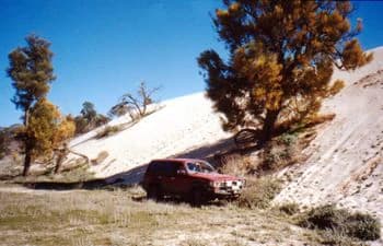
Wyperfeld National Park is best known for its vast, flat mallee landscape punctuated by distinctive sandhill formations known as "snowdrifts" that rise above otherwise level terrain. The park protects one of the largest remaining intact mallee ecosystems in Australia, a habitat characterized by dense, multi-stemmed eucalyptus shrubs adapted to semi-arid conditions. The park's ephemeral lake system, fed by the Wimmera River, creates周期性 wet periods that support unique wetland flora and fauna communities dominated by black box and river red gum forests. The park is particularly significant for its malleefowl population, a ground-dwelling bird that builds large nesting mounds in mallee soil.

Red SUV on dirt road with sandy hill, mallee trees, and clear blue sky
Red SUV parked near a sandy hill in Wyperfeld National Park, 2001.

Wyperfeld National Park history and protected-area timeline

Wyperfeld National Park was first declared in 1921, establishing protection for a portion of the mallee landscape in Victoria's north-west. The initial park boundary encompassed a relatively modest area compared to its current extent, as subsequent expansions over the decades have added substantial additional territory to the reserve. The park's establishment reflected a growing recognition in the early twentieth century of the need to preserve Victoria's unique mallee environments, which were being progressively cleared for agricultural development. The surrounding region, like much of north-western Victoria, was once a shallow sea approximately 25 million years ago, with the current landforms taking shape as the sea retreated between 40,000 and 15,000 years ago. Prior to European settlement, the area's network of ephemeral lakes operated on a natural cycle of filling and emptying roughly every twenty years, typically remaining dry for about half that period. More recently, agricultural irrigation and drainage projects in surrounding areas have disrupted the natural water supply to the park, with the lakes not having completely filled since 1975.

Wyperfeld National Park landscape and geographic character

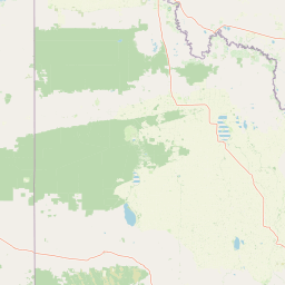
The landscape of Wyperfeld National Park is defined by its flat to gently undulating terrain overlaid with an ancient system of sand dunes. The sandhills, some described as "snowdrifts" due to their pale appearance against the darker mallee vegetation, represent the park's most distinctive topographic feature, rising above the otherwise level plain to create subtle but memorable variation in the scenery. The park's surface is predominantly sandy, a legacy of the marine sediments deposited when this area lay beneath shallow waters. The ephemeral lake system forms the landscape's most significant hydrological feature, with Lake Hindmarsh located immediately to the south of the park boundaries and Lake Albacutya bordering the park to the southeast. These lakes historically received water from the Wimmera River system, with overflows traveling through Outlet Creek to fill the downstream water bodies. Smaller interior lakes within the park itself fill during exceptional wet years, creating temporary wetland habitats that punctuate the otherwise dry mallee landscape. The vegetation is dominated by mallee eucalypts, dense multi-stemmed trees that rarely exceed ten metres in height but form a nearly continuous canopy across much of the park.

Wyperfeld National Park ecosystems, habitats, and plant life

Wyperfeld National Park protects one of Australia's most extensive remaining mallee ecosystems, a distinctive vegetation type characterized by dense stands of mallee eucalypts growing on sandy soils across semi-arid landscapes. The mallee vegetation within the park consists primarily of several Eucalyptus species that have adapted to the region's low rainfall and nutrient-poor soils through their characteristic multi-stemmed growth form, with individual plants regenerating from lignotubers after fire or drought. The park's lake systems, when filled, support distinctive riparian communities dominated by black box and river red gum, two eucalypt species that thrive in periodically inundated soils along water margins. Heathland communities occupy areas between the mallee woodlands, featuring diverse shrub species that add compositional variety to the park's vegetation. The ecological significance of the mallee ecosystem extends beyond its plant communities, as this habitat supports a distinctive suite of fauna species specially adapted to life in Australia's semi-arid interior.

Wyperfeld National Park wildlife and species highlights

Wyperfeld National Park provides critical habitat for the malleefowl, a ground-dwelling bird species that builds elaborate nesting mounds from decomposing vegetation in mallee soils. The park is recognized as part of the Wyperfeld, Big Desert and Ngarkat Important Bird Area, identified by BirdLife International for its significance in conserving malleefowl populations and other bird species associated with mallee woodlands. Beyond malleefowl, the park supports a diverse community of mallee bird species including various honeyeaters, parrots, and raptors that utilize the dense vegetation for feeding and nesting. When the park's lakes fill with water, they become important staging and breeding areas for waterbirds including ducks, swans, and migratory species that exploit the temporary wetland habitat. The river red gum and black box forests along watercourses provide nesting hollows for cockatoos and parrots, while the dense mallee understorey shelters reptiles, small mammals, and invertebrates adapted to the semi-arid conditions.

Wyperfeld National Park conservation status and protection priorities

Wyperfeld National Park plays a crucial role in conserving Victoria's mallee ecosystems, protecting one of the largest remaining tracts of this formerly widespread habitat type. The park is managed as part of the Victorian Mallee Parks network, a coordinated approach that links Wyperfeld with adjacent protected areas including Hattah-Kulkyne National Park, Murray-Sunset National Park, Lake Albacutya Park and Murray-Kulkyne Park to create a contiguous conservation landscape. This network approach recognizes that many mallee species require large areas of intact habitat and that connectivity between protected areas is essential for long-term population viability. The park's designation as an Important Bird Area for malleefowl conservation highlights its particular significance for species that have declined dramatically across much of their former range due to habitat loss and fragmentation. Conservation challenges in the park include managing the impacts of altered water regimes from surrounding agricultural development, controlling invasive species, and maintaining fire regimes appropriate for mallee ecosystem health.

Wyperfeld National Park cultural meaning and human context

The Wyperfeld area's human history is linked to the broader story of the Mallee region in north-western Victoria, though the park itself does not contain extensive documented evidence of indigenous cultural sites. The landscape's flat terrain and semi-arid conditions historically supported lower population densities of Aboriginal people compared to more fertile regions of Victoria. European exploration and settlement of the Mallee region occurred relatively late due to the area's limited agricultural potential and the challenges of accessing water. The establishment of the national park in 1921 represented an early recognition of the region's natural values, though the focus at that time was more on preserving timber resources than on ecological conservation as understood today. Contemporary park management acknowledges the traditional connection that Aboriginal people have to the Victorian Mallee landscape, though detailed cultural heritage information specific to the park area remains limited.

Top sights and standout views in Wyperfeld National Park

Wyperfeld National Park's defining highlight is its vast, untouched mallee wilderness that stretches to the horizon in every direction, creating one of Victoria's most expansive natural landscapes. The distinctive sandhill formations, particularly the pale "snowdrift" dunes, provide visual anchors that break the monotony of the flat terrain and offer viewpoints across the park. The periodic filling of the park's lake system, though increasingly rare due to water extraction, transforms the landscape dramatically and creates exceptional wildlife viewing opportunities when waterbirds congregate in large numbers. The park's status as a malleefowl stronghold represents a significant conservation highlight, offering visitors the possibility of encountering this unusual ground-nesting bird in its natural habitat. The relative remoteness and low visitor pressure at Wyperfeld contribute to a wilderness experience increasingly rare in populated southeastern Australia.

Best time to visit Wyperfeld National Park

The best time to visit Wyperfeld National Park depends on what visitors hope to experience, though autumn and spring typically offer the most comfortable conditions for exploring the park. Summer temperatures in the Mallee can be extremely hot, often exceeding 40 degrees Celsius, making outdoor activities difficult and potentially dangerous. Winter brings cooler daytime temperatures but can also feature cold nights and occasional rain, with the landscape often appearing stark and brown after the dry summer months. For wildlife viewing, the ideal time coincides with periods when the park's lakes hold water, as this creates the most biologically productive conditions and attracts the greatest diversity of birdlife. However, predicting when the lakes will fill is difficult since this depends on rainfall in the Wimmera catchment far to the south, and extended dry periods have become more common in recent decades. Visitors planning trips to Wyperfeld should check current conditions with Parks Victoria and be prepared for the park's remote location, which requires self-sufficiency in terms of supplies and vehicle preparation.

Park location guide

Geography guide, regional context, and park location map for Wyperfeld National Park

Wyperfeld National Park park geography, regions, and map view in Australia
Understand where Wyperfeld National Park sits in Australia through a broader geographic reading of the surrounding landscape, nearby location context, and its mapped position within the national park landscape.

How Wyperfeld National Park fits into Australia

Australia is a constitutional monarchy and federal parliamentary democracy comprising six states and ten territories. With a population of nearly 28 million, it is one of the world's most urbanised countries, with most people concentrated on the eastern seaboard. The country has a high Human Development Index and is known for its cultural diversity, ancient Aboriginal heritage, and unique wildlife.

Wider geography shaping Wyperfeld National Park in Australia

Australia occupies the entire Australian continent, the island of Tasmania, and numerous smaller islands. It is the world's flattest and driest inhabited continent, featuring vast deserts in the interior (the Outback), tropical rainforests along the eastern coast, and a coastline bordering the Indian and Pacific Oceans.

Map view of Wyperfeld National Park

Use this park location map to pinpoint Wyperfeld National Park in Australia, understand its exact geographic position, and read its mapped placement within the surrounding landscape more clearly.

Pigeon | © OpenStreetMap contributors

Explore protected area imagery, sandhill formations, mallee habitats, and the unique terrain that defines this Australian national park.

Wyperfeld National Park Photos: Visualizing Victoria's Mallee Landscapes and Semi-Arid Wilderness Environment
Visually explore the distinct mallee ecosystems, vast sandhill formations, and semi-arid terrain defining Wyperfeld National Park in Victoria, Australia. Detailed photography helps users understand the park's unique habitats, ephemeral lake landscapes, and the character of its expansive protected environment.

Red SUV on dirt road with sandy hill, mallee trees, and clear blue sky

Park atlas

Explore the rich network of Mallee protected areas, comparing landscapes and conservation efforts in Victoria.

Discover Other National Parks and Protected Areas Near Wyperfeld National Park
Browse a curated list of national parks and protected areas located in the same regional context as Wyperfeld National Park, spanning Victoria's unique Mallee wilderness. Compare diverse mallee ecosystems, sand dune formations, and semi-arid conservation landscapes to deepen your understanding of the broader geographic spread and interconnected protection efforts.
National park

Murray-Sunset National Park: Iconic Pink Lakes and Mallee Wilderness in Victoria's Semi-Arid Interior

Explore its unique landscape, mapped boundaries, and regional geography.

Murray-Sunset National Park offers a compelling glimpse into Australia's semi-arid heart, featuring a dramatic landscape of salt lakes, gypsum plains, extensive sand dunes, and dense mallee woodlands. This vast protected area is renowned for the vibrant pink hue of its salt lakes, a phenomenon created by microscopic algae that flourishes in the hypersaline conditions during warmer months. The park's rich biodiversity and unique ecosystem make it a significant conservation asset, providing crucial habitat for numerous species adapted to this challenging yet beautiful environment.

Area
6,330 km²
Established
1991
IUCN
II
Relief
Lowland
National park

Hattah-Kulkyne National Park: Victoria's Ramsar Wetland National Park & Mallee Landscape

Explore its mapped protected area and semi-arid regional geography.

Delve into Hattah-Kulkyne National Park, a substantial protected area in northwestern Victoria, Australia, defined by its striking red-earth terrain and sprawling mallee woodlands. This national park is renowned for its dynamic seasonal lake system, a key component of the Murray River basin's wetland geography. The park's status as a Ramsar-designated wetland highlights its ecological importance, providing critical habitat within a distinct semi-arid environment. Discover the unique atlas-scale landscape character and protected land context of this significant Australian natural area.

Area
480 km²
Established
1960
IUCN
II
Relief
Lowland
National park

Little Desert National Park: Victoria's Semi-Arid National Park and Protected Landscape

Explore mapped boundaries and unique mallee heathland ecosystems.

Delve into the protected landscape of Little Desert National Park, a significant national park covering over 1,300 square kilometers of Victoria's semi-arid western region. This area is characterized by its deep sandy soils, mallee heathlands, and diverse wildlife, including important populations of native birds. Understanding its geographic setting and mapped boundaries provides crucial insight into Australia's conservation efforts and the preservation of unique desert ecosystems.

Area
1,326.47 km²
Established
1988
IUCN
II
Visitors
50K annual
National parkNew South Wales

Mallee Cliffs National Park: Protected Landscape and Geographic Atlas Entry

Explore its mapped boundaries and regional New South Wales context.

Mallee Cliffs National Park is presented here as a distinct protected landscape, offering specific insights for atlas and geographic discovery. This entry details the park's national park designation and its position within New South Wales, highlighting its mapped boundaries and the surrounding regional geography. It provides the foundational geographic context needed to understand Mallee Cliffs National Park's presence within the broader landscape of protected areas, inviting detailed exploration for those interested in mapped natural terrain.

Area
579.69 km²
Established
1977
IUCN
II
Relief
Lowland
National parkSouth Australia

Murray River National Park: Protected Wetland Ecosystems in South Australia

Explore South Australia's unique river red gum floodplains.

Murray River National Park is a significant protected area in South Australia, renowned for its expansive wetland and floodplain environments situated along the Murray River. This national park preserves crucial habitats within the Murray-Darling Basin, characterized by river red gum woodlands, permanent water bodies, and dynamic seasonal floodplains. Its detailed maps and geographic context offer deep insights into one of Australia's most important riverine conservation landscapes.

Area
148.79 km²
Established
1991
IUCN
VI
Relief
Lowland
National parkNew South Wales

Yanga National Park National Park: Mapped Boundaries and Regional Geographic Context in New South Wales

Protected landscape atlas entry for New South Wales.

Examine Yanga National Park, a dedicated national park situated in New South Wales, Australia. This entry provides essential details for atlas-based discovery, focusing on its mapped boundaries, protected area status, and integration into the regional geography. Understanding Yanga National Park contributes to a broader comprehension of protected lands and their distribution, offering a clear geographic perspective on conservation efforts within New South Wales for users seeking structured landscape data.

Area
667.34 km²
Established
2007
IUCN
II
Relief
Lowland
National park

Kara Kara National Park: Mapped Protected Landscape and Box-Ironbark Forest Ecology

Explore Victoria's protected natural geography and woodland habitats.

Kara Kara National Park is an essential protected area in Victoria, Australia, recognized for its significant box-ironbark forest ecosystems and the conservation of the endangered swift parrot. The park's geography is defined by the St Arnaud Range, offering a distinct topography of ridges and valleys that contrast with the surrounding plains. Understanding this park's mapped boundaries and its role within the regional landscape provides critical insight into its ecological value and its representation of historical woodland environments.

Area
139.9 km²
Established
2002
IUCN
II
Relief
Upland
National parkSouth Australia

Naracoorte Caves National Park: Detailed Map and Protected Landscape Context in South Australia

Explore its unique protected geography and natural terrain.

Naracoorte Caves National Park represents a vital protected area within the diverse geography of South Australia. This entry provides an atlas-driven perspective, highlighting its identity as a national park, its mapped landscapes, and its regional significance. Engage with structured information detailing the park's protected status and geographic features, offering a clear view of its contribution to South Australia's natural heritage.

Area
6.6 km²
Established
2001
IUCN
II
Visitors
90.8K annual

Common questions about visiting, size, designation, and location context for Wyperfeld National Park

Wyperfeld National Park FAQs for park facts, access, geography, and protected area context
Find quick answers about Wyperfeld National Park, including protected-area facts, park geography, trail and visitor context, and how the park fits into its surrounding country and regional landscape.
MoriAtlas Explorer

Continue Your Protected Areas Search Across the Global Atlas

Deepen your exploration by continuing the structured search for national parks and protected areas worldwide. Utilize the comprehensive filtering capabilities to compare different conservation landscapes and refine your understanding of global park geography. Discover more about the distribution and characteristics of protected natural areas.

Global natural geography