

Mori Atlas logo
National parkKara Kara National Park

Discover the geographic context and unique woodland ecology of this Australian National Park.

Kara Kara National Park: A Mapped Protected Landscape of Box-Ironbark Forests in Victoria

Kara Kara National Park stands as a vital protected area in Victoria, Australia, representing one of the most intact box-ironbark forest ecosystems remaining. Situated within the St Arnaud Range, this national park offers a unique geographic setting with its rugged ridges rising from surrounding plains, providing a distinct landscape context. Its mapped boundaries encompass approximately 13,990 hectares, preserving a crucial habitat for species like the endangered swift parrot and offering a rare glimpse into a historical woodland environment.

box-ironbark forestwoodland parkbird habitatVictoria national parkswift parrot conservationSt Arnaud Range

Kara Kara National Park

National park

Park overview

Structured park overview, official facts, and landscape profile for Kara Kara National Park

Kara Kara National Park park facts, protected area profile, and essential visitor context

Review the core facts for Kara Kara National Park, including designation, size, terrain, visitor scale, habitats, and operating context in one park-focused overview.

About Kara Kara National Park

Kara Kara National Park occupies a distinctive place in Victoria's protected area network as one of the few substantial remnants of the state's original box-ironbark forest landscape. The park's terrain is dominated by the St Arnaud Range, a series of low ridges and valleys that create visual and ecological variety within the broader woodland context. The forests here are characterized by grey box and ironbark species, with an understory of native grasses and shrubs that support rich biodiversity. Unlike many other forest areas in the central goldfields region that have been heavily modified by mining, grazing, and agricultural clearance, parts of Kara Kara retain relatively unmodified vegetation structure, making the park particularly valuable for conservation. The park straddles the boundary between the Northern Grampians Shire and the Pyrenees Shire, with access provided via the Sunraysia Highway between Redbank and St Arnaud.

Quick facts and research context for Kara Kara National Park

Kara Kara National Park protects one of Victoria's most ecologically significant box-ironbark forest remnants in the state's north-west. The park spans roughly 14,000 hectares across the St Arnaud Range, lying between the towns of St Arnaud and Redbank along the Sunraysia Highway. The area holds importance for the Dja Dja Wurrung Indigenous people and has been recognized as an Important Bird Area due to its population of swift parrots and diverse woodland bird communities.

Protection and recognition

Mapping the official conservation framework and terrestrial management scope

Kara Kara National Park Protection Status and Terrestrial Designation History

Established in 2002, Kara Kara National Park maintains an official terrestrial designation to safeguard its localized natural terrain. Accessing verified designation records and terrestrial conservation frameworks helps trace the formal management scope of the park landscape.

Protection details

Protection scope
Terrestrial
Designated year
2002
Transboundary protection
No
Park context

Deeper park guide and search-rich context for Kara Kara National Park

Kara Kara National Park history, landscape, wildlife, and travel context

Explore Kara Kara National Park through its history, landscape character, ecosystems, wildlife, conservation priorities, cultural context, and seasonal travel timing in a structured park guide built for atlas discovery and search intent.

Why Kara Kara National Park stands out

Kara Kara National Park is best known for its relatively unmodified box-ironbark forests, which represent a rare surviving example of the woodland environment that once dominated much of central Victoria. The park provides critical habitat for the endangered swift parrot, a migratory species that relies on the nectar-producing trees of this forest type. The St Arnaud Range itself offers scenic relief from the surrounding flat agricultural landscape, with several walking and mountain biking tracks providing access to its ridges and valleys.

Kara Kara National Park history and protected-area timeline

The Kara Kara National Park was officially proclaimed on 30 October 2002, originally under the name St Arnaud Range National Park. This initial designation brought together the former Kara Kara State Park and the majority of the St Arnaud Range State Forest under national park protection. Following the release of a draft park management plan in April 2009 and subsequent consultations conducted under the Geographic Places Names Act 1998 and the Guidelines for Geographic Names 2010, the park was renamed to Kara Kara National Park in recognition of the historical significance of the Kara Kara name and its association with the area. The establishment of the park marked an important moment in Victoria's conservation efforts for box-ironbark ecosystems, which had historically received less protection than the state's wetter forest types.

Kara Kara National Park landscape and geographic character

The landscape of Kara Kara National Park is defined by the St Arnaud Range, a series of low but steep ridges and intervening valleys that rise from the surrounding Wimmera plains. The terrain creates a diversified topography with aspects ranging from exposed ridgelines to sheltered gullies, each supporting slightly different vegetation communities. The underlying geology contributes to the soil conditions that support the box-ironbark forest type, with rocky outcrops and exposed bedrock visible on some ridge crests. The forest canopy is relatively open compared to wetter forest types, allowing sunlight to reach the forest floor and support a diverse ground layer of native grasses and flowering plants.

Kara Kara National Park ecosystems, habitats, and plant life

The ecological character of Kara Kara National Park is defined by its box-ironbark forest, a distinctive vegetation community adapted to the relatively dry conditions of central Victoria. The grey box and ironbark trees form a spaced canopy that allows light to penetrate to the ground layer, where native grasses and herbaceous species thrive. This forest structure supports a remarkable diversity of wildlife, particularly woodland birds that have declined significantly across much of Victoria as their habitat has been cleared. The park lies within the St Arnaud Box-Ironbark Region, an area identified by BirdLife International as an Important Bird Area of global significance. The combination of intact forest structure, diverse understory, and proximity to other woodland remnants creates conditions that support populations of species that have become rare in the fragmented agricultural landscape.

Kara Kara National Park wildlife and species highlights

Kara Kara National Park provides essential habitat for several notable species, most prominently the swift parrot, a migratory parrot species that breeds in Tasmania and migrates to mainland Australia during the autumn and winter months. The swift parrot depends on the nectar from flowering eucalypts, particularly those found in box-ironbark forests, making protected areas like Kara Kara critically important for the species' survival. Beyond the swift parrot, the park supports a rich community of woodland birds including various honeyeaters, robins, and thornbills. The forest structure also provides shelter and nesting sites for mammals including possums and bats, while the ground layer supports reptiles and insects that form part of the broader food web.

Kara Kara National Park conservation status and protection priorities

The conservation significance of Kara Kara National Park stems from its role as one of the most intact remaining examples of Victoria's box-ironbark forest, a vegetation type that has been severely reduced by European settlement. The park protects forest that once covered approximately 13 percent of Victoria but now exists in fragmented remnants, making each protected area vital for maintaining biodiversity. The designation of the surrounding region as an Important Bird Area reflects the global significance of these woodlands for bird conservation, particularly for species like the swift parrot that is listed as endangered. The park also protects catchments and waterways that flow from the St Arnaud Range, contributing to broader landscape connectivity and watershed health.

Kara Kara National Park cultural meaning and human context

The Kara Kara National Park area holds significance for the Dja Dja Wurrung people, the Indigenous inhabitants of central Victoria whose traditional country encompasses the box-ironbark woodlands of the St Arnaud region. The landscape was shaped by thousands of years of Aboriginal land management practices, including fire regimes that maintained the open woodland character and supported the plant and animal species upon which Dja Dja Wurrung people depended. The park's establishment as a protected area formally acknowledges this cultural heritage, though the specific nature of Indigenous connections to the land would be further detailed in ongoing partnership with Traditional Owners.

Top sights and standout views in Kara Kara National Park

The St Arnaud Range provides the park's most distinctive landscape feature, with walking tracks offering views across the surrounding agricultural plains from elevated ridgelines. The box-ironbark forest itself is a highlight, particularly during autumn and winter when eucalypts flower and provide food for honeyeaters and migratory swift parrots. The network of walking and mountain biking tracks provides accessible opportunities to experience the park's natural values, with routes varying in difficulty and length. The relative remoteness and quiet of the park, away from more heavily visited destinations, offers a wilderness experience uncommon in Victoria's accessible protected areas.

Best time to visit Kara Kara National Park

The cooler months from late autumn through winter into early spring represent a particularly rewarding time to visit Kara Kara National Park, coinciding with the flowering of many eucalypts and the arrival of migratory swift parrots from Tasmania. This period offers excellent wildlife viewing opportunities as the parrots feed on nectar throughout the forest. Summer can be hot and dry, though the shaded forest tracks provide some respite, while spring brings wildflower displays in the understory. The park is accessible year-round, though visitors should be prepared for variable weather conditions and should check track conditions before setting out, as some routes may be affected by recent fire or weather events.
Monthly climate preview

Long term temperature cycles and monthly precipitation averages across the protected region

Kara Kara National Park Average Temperature and Weather by Month

Climatology records at the representative elevation of 274.88 meters show monthly mean temperatures ranging from 7.12 to 21.48 degrees Celsius. Exploring the complete twelve month profile provides the historical precipitation averages and temperature ranges mapped for Kara Kara National Park.
Annual mean14 °C
7 °C21 °C
Jan21°
Feb21°
Mar18°
Apr14°
May10°
Jun
Jul
Aug
Sep10°
Oct13°
Nov16°
Dec19°
Warmest month
January

21.5 °C

Coolest month
July

7.1 °C

Wettest month
June

2 mm/day

Driest month
March

0.8 mm/day

Park location guide

Geography guide, regional context, and park location map for Kara Kara National Park

Kara Kara National Park park geography, regions, and map view in Australia

Understand where Kara Kara National Park sits in Australia through a broader geographic reading of the surrounding landscape, nearby location context, and its mapped position within the national park landscape.

How Kara Kara National Park fits into Australia

Australia is a constitutional monarchy and federal parliamentary democracy comprising six states and ten territories. With a population of nearly 28 million, it is one of the world's most urbanised countries, with most people concentrated on the eastern seaboard. The country has a high Human Development Index and is known for its cultural diversity, ancient Aboriginal heritage, and unique wildlife.

Wider geography shaping Kara Kara National Park in Australia

Australia occupies the entire Australian continent, the island of Tasmania, and numerous smaller islands. It is the world's flattest and driest inhabited continent, featuring vast deserts in the interior (the Outback), tropical rainforests along the eastern coast, and a coastline bordering the Indian and Pacific Oceans.

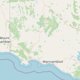
Map view of Kara Kara National Park

Use this park location map to pinpoint Kara Kara National Park in Australia, understand its exact geographic position, and read its mapped placement within the surrounding landscape more clearly.

Pigeon | © OpenStreetMap contributors
Park atlas

Trace the geographic spread of protected areas in Victoria, Australia, and compare landscapes surrounding Kara Kara National Park

Explore Nearby National Parks and Protected Areas Beyond Kara Kara National Park

Browse a curated list of national parks and protected areas in Victoria, offering diverse terrain and conservation value across the region surrounding Kara Kara National Park. This geographic overview allows for direct comparison of the unique box-ironbark forest with other protected landscapes, tracing regional ecological connections.
National parkAustralia
60 km away#1 closest

Southwest

Grampians National Park National Park: Sandstone Ranges and Aboriginal Heritage Atlas

Explore its mapped protected landscape and regional geography.

Grampians National Park stands as a testament to Victoria's natural and cultural heritage, featuring striking sandstone mountain ranges and an exceptional concentration of Aboriginal rock art sites. This protected area offers a deep dive into the region's unique geology, from its ancient sedimentary rock formations to its dramatic cliff faces and peaks. Understanding the park's mapped boundaries and its place within the broader geography provides essential context for appreciating its protected landscape identity and its millennia-long human history.

Area
1,672.19 km²
Established
1984
IUCN
II
Relief
Mountain
National parkAustralia
77 km away#2 closest

East

Greater Bendigo National Park: Essential Protected Landscape and Regional Geography Details

Map exploration of its box-ironbark forest and woodland ecosystems.

Delve into Greater Bendigo National Park, a protected area in Victoria renowned for its extensive box-ironbark forests. This national park is crucial for maintaining the distinct woodland ecosystems that support rich bird populations and provide essential habitat for the endangered swift parrot. Users can explore its mapped geographic extent, understand its landscape character, and appreciate its significance within Australia's protected natural areas.

Area
170 km²
Established
2002
IUCN
II
Relief
Lowland
National parkAustralia
103 km away#3 closest

Northeast

Terrick Terrick National Park: National Park Geography and Protected Land Exploration

Semi-arid woodland and grassland ecosystems in northern Victoria.

Terrick Terrick National Park represents a crucial protected area showcasing the characteristic Box-Ironbark forest and native grassland ecosystems of northern Victoria. This park is defined by its gently undulating terrain and semi-arid woodland character, offering a distinct natural landscape for geographic study and atlas exploration. Its mapped extent clearly delineates an environment vital for conservation, providing a valuable point of reference for understanding regional protected land distribution and ecological significance within Australia.

Area
38.8 km²
Established
1988
IUCN
II
Relief
Lowland
National parkAustralia
108 km away#4 closest

West

Little Desert National Park: Victoria's Semi-Arid National Park and Protected Landscape

Explore mapped boundaries and unique mallee heathland ecosystems.

Delve into the protected landscape of Little Desert National Park, a significant national park covering over 1,300 square kilometers of Victoria's semi-arid western region. This area is characterized by its deep sandy soils, mallee heathlands, and diverse wildlife, including important populations of native birds. Understanding its geographic setting and mapped boundaries provides crucial insight into Australia's conservation efforts and the preservation of unique desert ecosystems.

Area
1,326.47 km²
Established
1988
IUCN
II
Visitors
50K annual
National parkAustralia
120 km away#5 closest

Southeast

Brisbane Ranges National Park: Mapped Protected Terrain and Wildlife Observation

Explore its landscape context and geographic identity.

Brisbane Ranges National Park offers a protected natural landscape west of Melbourne, known for its accessible bushland scenery and wildlife observation opportunities. As a national park, it preserves a unique region of forested gullies and moderate elevation hills, providing valuable insight into Victoria's geographic diversity. Explore the mapped terrain, understand the park's role as a protected area, and discover the features that make it a distinct component of Australia's natural atlas.

Area
77.18 km²
Established
1973
IUCN
II
Relief
Upland
Watercolor painting of green trees, rolling hills, and a pastel sky.
National parkAustralia
121 km away#6 closest

East

Heathcote-Graytown National Park: Protected Box-Ironbark Forests and Swift Parrot Habitat

Mapping the landscape and geography of this Australian National Park.

Heathcote-Graytown National Park is a significant protected area safeguarding one of Victoria's remaining box-ironbark forest ecosystems. Its landscape, nestled within the Great Dividing Range, provides essential habitat for migratory swift parrots and supports diverse woodland bird species recognized by BirdLife International. Explore the park's mapped terrain and understand its role within the Central Highlands' regional geography as a vital conservation landscape.

Area
128.33 km²
Established
2002
IUCN
II
Relief
Mountain
National parkAustralia
132 km away#7 closest

Northeast

Gunbower National Park: A National Park Protecting River Red Gum Forests and Ramsar Wetlands

Explore its mapped riverine landscape and regional protected area context.

Gunbower National Park offers a unique glimpse into Victoria's vital floodplain ecosystems, prominently featuring extensive River Red Gum forests and Ramsar-designated wetlands. This protected national park, situated along the Murray River, serves as a crucial sanctuary for migratory bird species within the Murray-Darling Basin. Its landscape is defined by waterways like Gunbower Creek and a mosaic of aquatic habitats, representing an important conservation area for its ecological communities and geographic significance.

Area
93.3 km²
Established
2010
IUCN
II
Relief
Lowland
National parkAustralia
147 km away#8 closest

Northwest

Wyperfeld National Park: Mapping Victoria's Vast Mallee Semi-Arid Wilderness and Sandhill Landscapes

Discover the unique geography and protected terrain of this significant Australian national park.

Wyperfeld National Park in Victoria, Australia, is a prime example of a vast semi-arid wilderness landscape. It is best known for its extensive sandhill formations, referred to as 'snowdrifts,' which punctuate the otherwise flat terrain. The park also protects a significant ephemeral lake system and is a stronghold for the mallee ecosystem, offering a unique context for understanding dryland conservation and mapped natural areas. Its protected status highlights its importance within the broader geographic context of Australia's protected landscapes.

Area
3,570 km²
Established
1921
IUCN
II
Relief
Lowland

Common questions about visiting, size, designation, and location context for Kara Kara National Park

Kara Kara National Park FAQs for park facts, access, geography, and protected area context

Find quick answers about Kara Kara National Park, including protected-area facts, park geography, trail and visitor context, and how the park fits into its surrounding country and regional landscape.
MoriAtlas Explorer

Continue Your Protected Areas Search Across the Global Atlas

Deepen your exploration by continuing the structured search for national parks and protected areas worldwide. Utilize the comprehensive filtering capabilities to compare different conservation landscapes and refine your understanding of global park geography. Discover more about the distribution and characteristics of protected natural areas.

Global natural geography