

Mori Atlas logo
National parkMallee Cliffs National Park

Discover mapped park boundaries and regional landscape features within this Australian National Park.

Mallee Cliffs National Park: Protected Landscape and Geographic Context in New South Wales

Mallee Cliffs National Park represents a significant protected landscape within the broader geography of New South Wales, Australia. This page serves as your atlas entry point for understanding the park's specific identity as a national park, its geographic placement, and the natural terrain it encompasses. Explore the mapped extent of Mallee Cliffs National Park and gain insight into its role within the regional protected areas network, fostering a deeper appreciation for its mapped landscape.

Mallee WoodlandSemi-Arid LandscapeMalleefowl ConservationImportant Bird AreaRestricted Access ParkNumbat Reintroduction

Mallee Cliffs National Park

National park

Park overview

Structured park overview, official facts, and landscape profile for Mallee Cliffs National Park

Mallee Cliffs National Park park facts, protected area profile, and essential visitor context
Review the core facts for Mallee Cliffs National Park, including designation, size, terrain, visitor scale, habitats, and operating context in one park-focused overview.

About Mallee Cliffs National Park

Mallee Cliffs National Park protects one of the most significant remaining tracts of semi-arid mallee woodland in southeastern Australia. The park preserves the original clay red plains of southwestern New South Wales, maintaining extensive areas of flat to undulating sandy terrain and the characteristic linear sand dunes that define the Mallee Country landscape. This landscape developed during ancient arid periods, with dune formation occurring between 350,000 and 500,000 years ago, creating the foundation for the distinctive ecological communities that exist today. The park is located in the Sunraysia region, an area that has undergone substantial agricultural transformation through irrigation farming, making the protected mallee remnants within the park increasingly valuable as refugia for native species. The management focus centers on maintaining the ecological integrity of the sand plain and sand dune land systems, with particular attention to preserving the habitat conditions that support threatened wildlife populations.

Quick facts and research context for Mallee Cliffs National Park

Mallee Cliffs National Park covers 57,969 hectares in southwestern New South Wales, making it a substantial protected area within the semi-arid Mallee region. The park lies within the Southern NSW Mallee Important Bird Area, identified by BirdLife International as supporting significant populations of vulnerable bird species. The park preserves undisturbed mallee vegetation communities, including both bull mallee and whipstick mallee varieties, as well as rosewood-belah woodland. The park is the only reserve in New South Wales with malleefowl habitat, and in 2020 became a site for numbat reintroduction. Access is restricted to educational and research activities rather than general public visitation.

Park context

Deeper park guide and search-rich context for Mallee Cliffs National Park

Mallee Cliffs National Park history, landscape, wildlife, and travel context
Explore Mallee Cliffs National Park through its history, landscape character, ecosystems, wildlife, conservation priorities, cultural context, and seasonal travel timing in a structured park guide built for atlas discovery and search intent.

Why Mallee Cliffs National Park stands out

Mallee Cliffs National Park is best known as a dedicated conservation sanctuary for the malleefowl, a vulnerable ground-nesting bird that builds elaborate mound nests in mallee woodlands. The park represents the only reserve in New South Wales containing malleefowl habitat and serves as a critical stronghold for this species. The park is also notable for its restricted access policy, which prioritizes wildlife protection over general visitation. Additionally, the 2020 reintroduction of the endangered numbat marked a significant conservation milestone, making Mallee Cliffs one of the few Australian parks actively restoring extinct-local mammal species.

Mallee Cliffs National Park history and protected-area timeline

Mallee Cliffs National Park was established in April 1977 when the entire property was purchased by the Foundation for National Parks & Wildlife. The acquisition was driven by recognition of the area's significance as malleefowl habitat and the need to protect remaining mallee vegetation communities in the face of ongoing land clearing for agriculture. Unlike many Australian national parks that were created from former state forests or crown lands, Mallee Cliffs was deliberately purchased as a private conservation property and dedicated to protection. The restricted public access policy has been in place since establishment, reflecting the park's primary function as a wildlife sanctuary rather than a recreation destination. The 2020 numbat reintroduction marked a significant chapter in the park's conservation history, expanding its role from passive protection to active ecological restoration.

Mallee Cliffs National Park landscape and geographic character

The landscape of Mallee Cliffs National Park is defined by the classic features of the Australian semi-arid zone. The terrain consists of flat to gently undulating sandy red plains that extend across the property, interrupted by linear sand dunes oriented in parallel patterns that reflect ancient wind directions. These dunes were formed during Pleistocene-era arid periods when sand was blown across the landscape and stabilized by vegetation. The soils are characteristically sandy and red, giving the region its distinctive appearance. The vegetation is dominated by mallee, a growth form where eucalyptus trees develop multiple small stems from a lignotuberous root system, creating a distinctive multi-trunked appearance. Between the dune ridges, deeper soils support woodland communities including rosewood and belah, while the dune crests support more open mallee shrubland. The overall visual character is one of open, spaced woodland with an understory of grasses and shrubs adapted to low rainfall conditions.

Mallee Cliffs National Park ecosystems, habitats, and plant life

The park preserves undisturbed tracts of mallee vegetation that represent an important representation of this ecological community in New South Wales. Mallee refers to a group of eucalyptus species and a distinctive growth form characterized by multiple stems arising from a large underground woody root system called a lignotuber, which allows the plants to survive fire and drought. The park contains both bull mallee and whipstick mallee forms, as well as the less common rosewood-belah woodland community that occurs on deeper soils between dunes. The mallee spinifex grassland provides important habitat structure across much of the park. Several isolated relict plant communities exist within the park, demonstrating the historical patterns of vegetation across the landscape and how species distributions have shifted over time in response to changing climate conditions. These relict communities provide important insight into the ecological history of the Mallee region.

Mallee Cliffs National Park wildlife and species highlights

The wildlife of Mallee Cliffs National Park is centered on the vulnerable malleefowl, which remains the park's flagship species. The park is the only reserve in New South Wales containing malleefowl habitat, and the birds occur here in the characteristic mallee woodlands where they build their large mound nests. Male malleefowl construct elaborate nest mounds by digging pits in winter and filling them with leaves and grass over several months, then covering the organic material with sand. The decomposing vegetation generates heat that incubates the eggs, and males actively manage mound temperature throughout the breeding season. The park also supports significant populations of western grey kangaroos, and a variety of marsupials including pygmy possums. Several bat species utilize the park, with the little pied bat and greater long-eared bat using tree hollows for roosting. The mallee spinifex provides crucial habitat for the western blue-tongue lizard and southern spinifex slender blue-tongue. The 2020 reintroduction of the endangered numbat added a significant mammal species to the park's fauna.

Mallee Cliffs National Park conservation status and protection priorities

Mallee Cliffs National Park serves as a critical conservation refuge for semi-arid woodland ecosystems that have been extensively cleared across much of their former range. The park lies within the Southern NSW Mallee Important Bird Area, recognized by BirdLife International as supporting significant populations of vulnerable bird species, particularly the malleefowl. The restricted access policy reflects the park's primary conservation function, limiting public disturbance to protect breeding malleefowl and other threatened animals. The numbat reintroduction project, which began in 2020 with the goal of establishing a population of up to 270 individuals, demonstrates the park's evolving role in active conservation management. The protection of relict plant communities within the park provides insurance against ongoing environmental change and maintains genetic diversity of Mallee vegetation types that continue to face clearing pressures on surrounding private land.

Mallee Cliffs National Park cultural meaning and human context

The Mallee Cliffs area lies within the traditional lands of Aboriginal peoples who inhabited the semi-arid mallee woodlands for thousands of years before European settlement. The mallee vegetation communities would have provided resources for Indigenous communities, though the specific cultural associations with this particular area are not extensively documented in available sources. The landscape's name reflects the dominant vegetation type, with "mallee" being a term applied to the multi-stemmed eucalyptus growth form common across Australia's arid and semi-arid zones. The Sunraysia region name refers to the sunny, warm climate that characterizes this part of the Murray-Darling Basin, and the area around Mildura has a history of irrigation-based agriculture that has transformed much of the surrounding landscape from its original mallee-covered state.

Top sights and standout views in Mallee Cliffs National Park

Mallee Cliffs National Park represents one of the most significant protected areas for semi-arid mallee woodland ecosystems in southeastern Australia. The park's role as the sole reserve in New South Wales containing malleefowl habitat makes it irreplaceable for conservation of this vulnerable species. The 2020 numbat reintroduction marked an important milestone, establishing the park as a site of active mammal restoration. The restricted access policy, while limiting general visitation, ensures that the park functions primarily as a wildlife sanctuary rather than a recreation site. The ancient sand dune landscape, formed between 350,000 and 500,000 years ago, provides a geological foundation for the distinctive mallee vegetation communities that define the park's character.

Best time to visit Mallee Cliffs National Park

Mallee Cliffs National Park maintains restricted public access and is not generally open for recreational visitation. Access is limited to educational activities by schools and colleges, and research activities that are relevant to park management and compatible with conservation objectives. Those interested in visiting for educational purposes should contact the NSW National Parks and Wildlife Service to arrange access. The park's wildlife, particularly malleefowl, follows seasonal breeding patterns with mound building occurring in winter and egg laying in spring, meaning any authorized visits during these seasons may offer opportunities to observe breeding behavior.
Park location guide

Geography guide, regional context, and park location map for Mallee Cliffs National Park

Mallee Cliffs National Park park geography, regions, and map view in Australia
Understand where Mallee Cliffs National Park sits in Australia through a broader geographic reading of the surrounding landscape, nearby location context, and its mapped position within the national park landscape.

How Mallee Cliffs National Park fits into Australia

Australia is a constitutional monarchy and federal parliamentary democracy comprising six states and ten territories. With a population of nearly 28 million, it is one of the world's most urbanised countries, with most people concentrated on the eastern seaboard. The country has a high Human Development Index and is known for its cultural diversity, ancient Aboriginal heritage, and unique wildlife.

Wider geography shaping Mallee Cliffs National Park in Australia

Australia occupies the entire Australian continent, the island of Tasmania, and numerous smaller islands. It is the world's flattest and driest inhabited continent, featuring vast deserts in the interior (the Outback), tropical rainforests along the eastern coast, and a coastline bordering the Indian and Pacific Oceans.

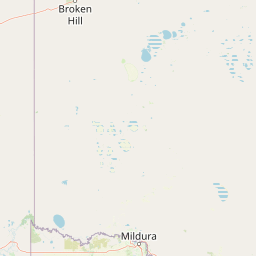
Map view of Mallee Cliffs National Park

Use this park location map to pinpoint Mallee Cliffs National Park in Australia, understand its exact geographic position, and read its mapped placement within the surrounding landscape more clearly.

Pigeon | © OpenStreetMap contributors

Location context for Mallee Cliffs National Park

New South Wales
Park atlas

Compare nearby protected areas and trace the geographic spread of national parks across the wider Mallee Country region.

Discover Other National Parks and Protected Areas Near Mallee Cliffs National Park
After exploring Mallee Cliffs National Park, browse other protected areas within its regional context to understand broader conservation efforts for semi-arid mallee woodlands and ancient sand dune systems. Compare the unique characteristics of nearby national parks and reserves, gaining insight into their distinct landscapes, ecosystems, and wildlife protection strategies in southwestern New South Wales.
National park

Hattah-Kulkyne National Park: Victoria's Ramsar Wetland National Park & Mallee Landscape

Explore its mapped protected area and semi-arid regional geography.

Delve into Hattah-Kulkyne National Park, a substantial protected area in northwestern Victoria, Australia, defined by its striking red-earth terrain and sprawling mallee woodlands. This national park is renowned for its dynamic seasonal lake system, a key component of the Murray River basin's wetland geography. The park's status as a Ramsar-designated wetland highlights its ecological importance, providing critical habitat within a distinct semi-arid environment. Discover the unique atlas-scale landscape character and protected land context of this significant Australian natural area.

Area
480 km²
Established
1960
IUCN
II
Relief
Lowland
National park

Murray-Sunset National Park: Iconic Pink Lakes and Mallee Wilderness in Victoria's Semi-Arid Interior

Explore its unique landscape, mapped boundaries, and regional geography.

Murray-Sunset National Park offers a compelling glimpse into Australia's semi-arid heart, featuring a dramatic landscape of salt lakes, gypsum plains, extensive sand dunes, and dense mallee woodlands. This vast protected area is renowned for the vibrant pink hue of its salt lakes, a phenomenon created by microscopic algae that flourishes in the hypersaline conditions during warmer months. The park's rich biodiversity and unique ecosystem make it a significant conservation asset, providing crucial habitat for numerous species adapted to this challenging yet beautiful environment.

Area
6,330 km²
Established
1991
IUCN
II
Relief
Lowland
National parkNew South Wales

Yanga National Park National Park: Mapped Boundaries and Regional Geographic Context in New South Wales

Protected landscape atlas entry for New South Wales.

Examine Yanga National Park, a dedicated national park situated in New South Wales, Australia. This entry provides essential details for atlas-based discovery, focusing on its mapped boundaries, protected area status, and integration into the regional geography. Understanding Yanga National Park contributes to a broader comprehension of protected lands and their distribution, offering a clear geographic perspective on conservation efforts within New South Wales for users seeking structured landscape data.

Area
667.34 km²
Established
2007
IUCN
II
Relief
Lowland
National park

Wyperfeld National Park: Mapping Victoria's Vast Mallee Semi-Arid Wilderness and Sandhill Landscapes

Discover the unique geography and protected terrain of this significant Australian national park.

Wyperfeld National Park in Victoria, Australia, is a prime example of a vast semi-arid wilderness landscape. It is best known for its extensive sandhill formations, referred to as 'snowdrifts,' which punctuate the otherwise flat terrain. The park also protects a significant ephemeral lake system and is a stronghold for the mallee ecosystem, offering a unique context for understanding dryland conservation and mapped natural areas. Its protected status highlights its importance within the broader geographic context of Australia's protected landscapes.

Area
3,570 km²
Established
1921
IUCN
II
Relief
Lowland
National parkNew South Wales

Kinchega National Park: National Park Protected Area in New South Wales

Explore the mapped Darling River terrain and outback landscapes.

Kinchega National Park stands as a protected national park entity within New South Wales, Australia. Its geographic significance is deeply tied to the Darling River, which shapes its unique riparian ecosystems and contrasts with the surrounding semi-arid outback terrain. This park offers a valuable point for atlas-based discovery, allowing exploration of its mapped boundaries, landscape context, and the conservation of its distinct natural and cultural heritage within the regional geography.

Area
442.59 km²
Established
1967
IUCN
II
Climate
Arid
National parkSouth Australia

Murray River National Park: Protected Wetland Ecosystems in South Australia

Explore South Australia's unique river red gum floodplains.

Murray River National Park is a significant protected area in South Australia, renowned for its expansive wetland and floodplain environments situated along the Murray River. This national park preserves crucial habitats within the Murray-Darling Basin, characterized by river red gum woodlands, permanent water bodies, and dynamic seasonal floodplains. Its detailed maps and geographic context offer deep insights into one of Australia's most important riverine conservation landscapes.

Area
148.79 km²
Established
1991
IUCN
VI
Relief
Lowland
National parkNew South Wales

Willandra National Park: National Park Protected Landscape & Geographic Context

Discover mapped boundaries within this New South Wales protected area.

Willandra National Park is a designated national park in New South Wales, Australia, offering focused opportunities for understanding protected landscapes. This entry provides essential geographic context and highlights the importance of mapped park boundaries for atlas-driven exploration. Users can engage with the park's specific landscape identity and its contribution to the broader regional geography of New South Wales through structured data.

Area
193.86 km²
Established
1972
IUCN
II
Relief
Lowland
National parkNew South Wales

Oolambeyan National Park National Park: Discover its Mapped Geography and Protected Landscape

Explore the protected area and regional context of New South Wales.

Delve into Oolambeyan National Park, a key national park within New South Wales, Australia. This entry provides essential geographic context, detailing the park's mapped boundaries and its identity as a protected landscape. It serves as a foundation for understanding the park's contribution to the regional atlas and offers a distinct perspective on the natural geography of the area.

Area
222.31 km²
Established
2001
IUCN
II
Access
Moderate access

Common questions about visiting, size, designation, and location context for Mallee Cliffs National Park

Mallee Cliffs National Park FAQs for park facts, access, geography, and protected area context
Find quick answers about Mallee Cliffs National Park, including protected-area facts, park geography, trail and visitor context, and how the park fits into its surrounding country and regional landscape.
MoriAtlas Explorer

Continue Your Protected Areas Search Across the Global Atlas

Deepen your exploration by continuing the structured search for national parks and protected areas worldwide. Utilize the comprehensive filtering capabilities to compare different conservation landscapes and refine your understanding of global park geography. Discover more about the distribution and characteristics of protected natural areas.

Global natural geography