

Mori Atlas logo
National parkYanga National Park

Explore the mapped boundaries and regional geography of this key protected landscape.

Yanga National Park: National Park Protected Area Atlas and Geographic Context in New South Wales

Yanga National Park stands as a significant national park within the broader atlas of New South Wales, Australia. This protected area offers a defined geographic scope for exploration, highlighting its specific role within the regional landscape context. As a mapped protected land, Yanga National Park provides foundational data for understanding conservation landscapes and natural terrain distribution across the state. Its designation as a national park underscores its importance for structured geographic discovery and atlas-based analysis of protected natural areas.

wetlandsriver red gum forestwaterbird habitatfloodplain ecosystemMurray-Darling Basincolonial nesting birds

Yanga National Park

National park

Park overview

Structured park overview, official facts, and landscape profile for Yanga National Park

Yanga National Park park facts, protected area profile, and essential visitor context

Review the core facts for Yanga National Park, including designation, size, terrain, visitor scale, habitats, and operating context in one park-focused overview.

About Yanga National Park

Yanga National Park represents a significant conservation achievement in New South Wales, transforming from one of Australia's largest historic pastoral stations to a protected wetland sanctuary. The park occupies a strategic position on the Lower Murrumbidgee Floodplain, an extensive inland wetland system that supports extraordinary biodiversity despite the surrounding semi-arid landscape. The floodplain ecosystem depends on periodic natural flooding events to maintain its ecological character, and the park's wetlands provide critical habitat during both wet and dry periods. Four significant lakes including Yanga Lake, Tala Lake, Piggery Lake, and Irrigation Lake dot the landscape, alongside hundreds of waterways including canals and natural creeks. The river red gum forests that line the Murrumbidgee River represent a continuation of the forest that extends through the broader Murrumbidgee Valley National Park, collectively forming the largest continuous river red gum forest in the world. Beyond the river corridor, the landscape encompasses black box woodlands, lignum shrublands, and sedgeland communities that together support the park's remarkable diversity of flora and fauna.

Quick facts and research context for Yanga National Park

Yanga National Park spans 66,734 hectares in southwestern New South Wales, situated on the Lower Murrumbidgee Floodplain near the town of Balranald. The park was created in February 2007 following the NSW Government's purchase of the historic Yanga pastoral station, which at its peak in the 19th century was the largest privately owned station in the southern hemisphere. The park includes the 1,932-hectare Yanga Nature Reserve, established in 1974. The park features a 170-kilometre frontage along the Murrumbidgee River and contains four significant lakes including Yanga Lake. The semi-arid climate receives approximately 320 millimetres of annual rainfall with hot summers and high evaporation rates throughout the year.

Protection and recognition

Tracking the official 2007 establishment history and terrestrial conservation framework

Documented Protection Status and Terrestrial Designation of Yanga National Park

Established in 2007, Yanga National Park represents a dedicated terrestrial protected area managed under official regional conservation frameworks. National park databases record the official boundary definitions, protection status, and terrestrial management scope to aid global geographic research and conservation tracking.

Protection details

Protection scope
Terrestrial
Designated year
2007
Transboundary protection
No
Park context

Deeper park guide and search-rich context for Yanga National Park

Yanga National Park history, landscape, wildlife, and travel context

Explore Yanga National Park through its history, landscape character, ecosystems, wildlife, conservation priorities, cultural context, and seasonal travel timing in a structured park guide built for atlas discovery and search intent.

Why Yanga National Park stands out

Yanga National Park is best known for its exceptional wetland values and waterbird populations. The park contains twelve different wetland types classified under the Ramsar Convention system, making it one of the most ecologically diverse wetland complexes in eastern Australia. It supports some of the largest waterbird breeding colonies on the continent and provides critical habitat for colonial nesting species including ibis, egrets, spoonbills, and cormorants when flood events occur. The park is also significant for protecting the endangered southern bell frog, which represents the largest known population in New South Wales. The extensive river red gum forests along the Murrumbidgee River corridor form a component of the world's largest continuous tract of this iconic Australian tree species.

Yanga National Park history and protected-area timeline

Yanga National Park has a rich European settlement history dating to the 1830s when explorer William Wentworth established the Yanga pastoral station. The property later became part of C.B. Fisher's extensive pastoral empire and at its peak covered approximately 210,000 acres, making it the largest privately owned station in the southern hemisphere. The Yanga homestead was constructed around 1870 and remains standing within the park today as a heritage reminder of the property's pastoral era. Prior to government purchase in 2005, over 90 percent of the land had been used for grazing, with the exception of the 1,932-hectare Yanga Nature Reserve established in 1974 under the National Parks and Wildlife Act 1974. In July 2005, the New South Wales Government announced the purchase of the station for conservation purposes, and the area was officially gazetted as a national park on 28 February 2007. In 2010, Yanga became part of the larger Murrumbidgee Valley National Park, created to protect the interconnected floodplain ecosystem. The park also holds significance for the Muthi Muthi people, whose traditional tribal lands encompass the area, and the NSW National Parks and Wildlife Service maintains an Aboriginal sites register documenting mounds, scarred trees, historic sites, burials, and middens throughout the park.

Yanga National Park landscape and geographic character

The Yanga National Park landscape is dominated by the extensive Lowbidgee Floodplain, a flat to gently undulating terrain characterized by river channels, lakes, billabongs, and expansive wetlands. The Murrumbidgee River flows through the park for 170 kilometres, with the river red gum forest forming a prominent green corridor along its banks. The floodplain contains four major lakes: Yanga Lake, Tala Lake, Piggery Lake, and Irrigation Lake, alongside numerous smaller water bodies and interconnected waterways. Beyond the river corridor, the landscape transitions into black box woodlands on the floodplain margins and extensive lignum shrubland in the drier zones. The semi-arid setting receives approximately 320 millimetres of rainfall annually, yet the floodplain's hydrology supports permanent wetland vegetation despite the surrounding arid conditions. The flat terrain is broken only by subtle elevation changes as the floodplain rises toward surrounding semi-arid plains, creating a landscape where water, forest, and open woodland intermingle across vast distances.

Yanga National Park ecosystems, habitats, and plant life

The ecological character of Yanga National Park centers on its diverse wetland systems, with twelve different wetland types identified according to the Ramsar Convention classification system including both inland wetlands and human-made wetlands. Seventeen distinct vegetation classes have been recorded within the park, supporting more than 300 plant species. The river red gum forest and woodland represents the dominant vegetation community along the Murrumbidgee corridor, while black box woodland occupies the floodplain margins. Lignum shrubland dominated by Chenopodium nitrariaceum and spike rush sedgeland characterize the wetland margins. The Lowbidgee Floodplain's national environmental significance was recognized through its listing as a Nationally Important Wetland in 2000, acknowledging its exceptional value as a breeding site for waterbirds when flooded and its role in supporting ecological processes throughout the Murray-Darling Basin.

Yanga National Park wildlife and species highlights

Yanga National Park supports remarkable biodiversity across multiple animal groups. The park records 24 reptile species including geckos, goannas, dragons, skinks, snakes, and turtles, while 18 fish species have been documented with European carp dominating many waterways. Thirty-three mammal species occur in the park, including seven introduced species such as red fox, red deer, feral cat, brown hare, rabbit, house mouse, and feral pig. The waterbird fauna is particularly significant, with 64 waterbird species from 14 families recorded in the park. Twelve species listed as vulnerable under the Environment Protection and Biodiversity Conservation Act 1999 have been documented, including the Australasian bittern, freckled duck, and blue-billed duck. The park supports the largest known population of the endangered southern bell frog in New South Wales, a species that has declined dramatically across its former range in southeastern Australia since the early 1980s. Eleven migratory bird species protected under international agreements including JAMBA, CAMBA, and ROKAMBA regularly use the wetlands, including Caspian tern, Latham's snipe, cattle egret, and black-tailed godwit.

Yanga National Park conservation status and protection priorities

Yanga National Park plays a crucial role in protecting some of Australia's most significant wetland ecosystems within the Murray-Darling Basin. The park forms part of a Nationally Important Wetland and supports two endangered ecological communities under New South Wales law: Myall woodland and an aquatic ecological community in the natural drainage system of the lower Murray River catchment. Twenty-one endangered or vulnerable fauna species have been recorded within the park, alongside two endangered and two vulnerable flora species. The park's protection addresses major conservation threats including habitat loss from historical grazing, altered flow regimes from river regulation, and impacts from introduced species. Environmental watering programs have delivered over 200,000 megalitres of water to the wetlands since 2005, achieving remarkable ecological recovery in flood-dependent vegetation communities and supporting threatened species populations. The establishment of the park ended destructive land management practices including grazing, clearing, logging, and burning that had degraded the floodplain ecosystem.

Yanga National Park cultural meaning and human context

Yanga National Park lies within the traditional tribal areas of the Muthi Muthi people, whose cultural connection to the landscape predates European settlement by thousands of years. The NSW National Parks and Wildlife Service has developed an Aboriginal sites register covering the park that documents various heritage features including mounds, scarred trees, historic sites, burials, and middens, reflecting the long history of Aboriginal occupation and land use in the area. The Service maintains a statutory role in the protection and preservation of these Aboriginal sites. The park also holds significance for early European exploration and settlement in the region, with the Yanga homestead built around 1870 still standing as a reminder of the pastoral era when this was the largest privately owned station in the southern hemisphere.

Top sights and standout views in Yanga National Park

The Yanga National Park experience centers on its extraordinary wetland wilderness in an otherwise semi-arid landscape. Visitors can explore extensive river red gum forests along the Murrumbidgee River, where the Mamanga campground provides access to the waterway. The park's wetland systems support exceptional birdwatching opportunities, with colonial nesting waterbirds including ibis, egrets, spoonbills, and cormorants breeding in the lignum floodways and flooded forest areas. The four major lakes, particularly Yanga Lake, provide permanent water bodies supporting diverse waterbird populations year-round. The park's recent establishment in 2007 and incorporation into the larger Murrumbidgee Valley National Park in 2010 means the ecosystem is in active recovery through environmental watering programs that have restored areas not flooded since the late 1980s.

Best time to visit Yanga National Park

The optimal time to experience Yanga National Park depends on water conditions, which vary significantly between years based on rainfall and environmental water deliveries. Spring and autumn typically offer the most comfortable temperatures for outdoor exploration, with mild days and cooler nights. The park's wildlife viewing is particularly rewarding following periods of flooding, when waterbird breeding colonies become active and the landscape transforms with abundant water and lush vegetation. Summer months can be extremely hot with temperatures regularly exceeding 40 degrees Celsius, while winters are mild but the park's wetlands may be at their driest. Visitors interested in waterbird observation should monitor conditions, as the park's ecological character depends on wet periods to support the breeding cycles that make this area so significant for colonial waterbird species.
Monthly climate preview

Historical temperature cycles and monthly precipitation averages in New South Wales

Climate Normals and Monthly Weather Patterns in Yanga National Park

Long-term representative measurements indicate a climate with extreme peak temperatures exceeding forty degrees Celsius alongside cool periods that drop close to freezing. Accessing the full monthly breakdown provides detailed precipitation averages and historical temperature ranges based on three decades of verified climatology.
Annual mean18 °C
9 °C27 °C
Jan27°
Feb26°
Mar22°
Apr17°
May13°
Jun10°
Jul
Aug10°
Sep14°
Oct18°
Nov21°
Dec24°
Warmest month
January

26.6 °C

Coolest month
July

9.1 °C

Wettest month
November

1.2 mm/day

Driest month
March

0.6 mm/day

Park location guide

Geography guide, regional context, and park location map for Yanga National Park

Yanga National Park park geography, regions, and map view in Australia

Understand where Yanga National Park sits in Australia through a broader geographic reading of the surrounding landscape, nearby location context, and its mapped position within the national park landscape.

How Yanga National Park fits into Australia

Australia is a constitutional monarchy and federal parliamentary democracy comprising six states and ten territories. With a population of nearly 28 million, it is one of the world's most urbanised countries, with most people concentrated on the eastern seaboard. The country has a high Human Development Index and is known for its cultural diversity, ancient Aboriginal heritage, and unique wildlife.

Wider geography shaping Yanga National Park in Australia

Australia occupies the entire Australian continent, the island of Tasmania, and numerous smaller islands. It is the world's flattest and driest inhabited continent, featuring vast deserts in the interior (the Outback), tropical rainforests along the eastern coast, and a coastline bordering the Indian and Pacific Oceans.

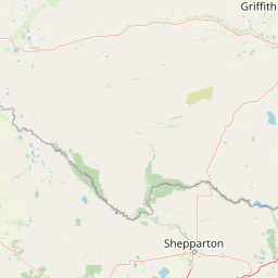
Map view of Yanga National Park

Use this park location map to pinpoint Yanga National Park in Australia, understand its exact geographic position, and read its mapped placement within the surrounding landscape more clearly.

Pigeon | © OpenStreetMap contributors

Location context for Yanga National Park

New South Wales
Natural feature types

Browse the Diverse Natural Features and Landforms of Yanga National Park

Deepen your understanding of Yanga National Park by exploring the specific natural features that define its geography. MoriAtlas organizes these landmarks to assist in visualizing the riverine, wetland, and woodland character of this vital protected area within the Murrumbidgee Valley.
Recorded earthquake history

Explore Historical Earthquake Records Associated with Yanga National Park

View a structured record of seismic events associated with the geography of Yanga National Park through the MoriAtlas catalogue. This resource allows for the examination of historical magnitude, depth, and epicentre distance data for the region.

Yanga National Park Earthquake History

Catalogued events

1 event

Strongest magnitude

Magnitude 3.1

Most recent event

Mar 10, 2003

This history includes earthquakes recorded inside the park or within 50 km of its borders

Park atlas

Map adjacent protected landscapes, tracing wetland systems and river red gum forests across the Lowbidgee Floodplain.

Discover Other Protected Areas Near Yanga National Park in Australia's Murrumbidgee Floodplain

Continue your exploration from Yanga National Park by mapping other protected areas and national parks across Australia's Murray-Darling Basin. Compare diverse wetland habitats, extensive river red gum forests, and critical waterbird ecosystems within their regional geographic context.
National parkNew South Wales
48 km away#1 closest

Southeast

Murray Valley National Park: Explore its Mapped Boundaries and Regional Geography in New South Wales

Protected landscape identity and geographic context.

Gain a structured understanding of Murray Valley National Park, a designated national park within New South Wales. This detail page provides essential geographic context, highlighting the park's mapped boundaries and its significance as a protected natural landscape. Utilize this entry point for comprehensive atlas-based exploration of its unique regional setting and terrain.

Area
416.01 km²
Established
2010
IUCN
II
Relief
Lowland
National parkNew South Wales
83 km away#2 closest

Northwest

Mungo National Park: Protected Landscape Atlas and Geographic Context

Explore mapped boundaries and regional terrain within New South Wales.

Mungo National Park offers a distinct focus for atlas exploration, presenting itself as a key protected landscape within the state of New South Wales, Australia. This entry details the park's geographic positioning and mapped boundaries, allowing for a clear understanding of its terrain and regional context. Engage with the park's identity as a protected area, uncovering the specifics of its natural landscape for a richer geographic discovery experience.

Area
1,109.67 km²
Established
1979
IUCN
II
Relief
Lowland
National parkAustralia
90 km away#3 closest

West

Hattah-Kulkyne National Park: Victoria's Ramsar Wetland National Park & Mallee Landscape

Explore its mapped protected area and semi-arid regional geography.

Delve into Hattah-Kulkyne National Park, a substantial protected area in northwestern Victoria, Australia, defined by its striking red-earth terrain and sprawling mallee woodlands. This national park is renowned for its dynamic seasonal lake system, a key component of the Murray River basin's wetland geography. The park's status as a Ramsar-designated wetland highlights its ecological importance, providing critical habitat within a distinct semi-arid environment. Discover the unique atlas-scale landscape character and protected land context of this significant Australian natural area.

Area
480 km²
Established
1960
IUCN
II
Relief
Lowland
National parkNew South Wales
About 101 km away#4 closest

Northwest

Mallee Cliffs National Park: Protected Landscape and Geographic Atlas Entry

Explore its mapped boundaries and regional New South Wales context.

Mallee Cliffs National Park is presented here as a distinct protected landscape, offering specific insights for atlas and geographic discovery. This entry details the park's national park designation and its position within New South Wales, highlighting its mapped boundaries and the surrounding regional geography. It provides the foundational geographic context needed to understand Mallee Cliffs National Park's presence within the broader landscape of protected areas, inviting detailed exploration for those interested in mapped natural terrain.

Area
579.69 km²
Established
1977
IUCN
II
Relief
Lowland
National parkAustralia
112 km away#5 closest

West

Murray-Sunset National Park: Iconic Pink Lakes and Mallee Wilderness in Victoria's Semi-Arid Interior

Explore its unique landscape, mapped boundaries, and regional geography.

Murray-Sunset National Park offers a compelling glimpse into Australia's semi-arid heart, featuring a dramatic landscape of salt lakes, gypsum plains, extensive sand dunes, and dense mallee woodlands. This vast protected area is renowned for the vibrant pink hue of its salt lakes, a phenomenon created by microscopic algae that flourishes in the hypersaline conditions during warmer months. The park's rich biodiversity and unique ecosystem make it a significant conservation asset, providing crucial habitat for numerous species adapted to this challenging yet beautiful environment.

Area
6,330 km²
Established
1991
IUCN
II
Relief
Lowland
Biosphere reserveVictoria
About 114 km away#6 closest

West

Hattah-Kulkyne and Murray-Kulkyne Biosphere Reserve: Protected Geography and Mapped Landforms

An inland mosaic of river corridors and semi-arid mallee habitats.

Located in northwestern Victoria, this biosphere reserve encompasses a distinct ecological assembly of Hattah lakes, seasonal floodplains, and sand-ridge terrains. Understand the interplay between the Murray River system and the surrounding dryland vegetation through detailed geographic context.

Area
515 km²
Established
1981
Visitors
99K annual
Relief
Lowland
National parkNew South Wales
122 km away#7 closest

East

Oolambeyan National Park National Park: Discover its Mapped Geography and Protected Landscape

Explore the protected area and regional context of New South Wales.

Delve into Oolambeyan National Park, a key national park within New South Wales, Australia. This entry provides essential geographic context, detailing the park's mapped boundaries and its identity as a protected landscape. It serves as a foundation for understanding the park's contribution to the regional atlas and offers a distinct perspective on the natural geography of the area.

Area
222.31 km²
Established
2001
IUCN
II
Access
Moderate access
National parkAustralia
123 km away#8 closest

Southeast

Gunbower National Park: A National Park Protecting River Red Gum Forests and Ramsar Wetlands

Explore its mapped riverine landscape and regional protected area context.

Gunbower National Park offers a unique glimpse into Victoria's vital floodplain ecosystems, prominently featuring extensive River Red Gum forests and Ramsar-designated wetlands. This protected national park, situated along the Murray River, serves as a crucial sanctuary for migratory bird species within the Murray-Darling Basin. Its landscape is defined by waterways like Gunbower Creek and a mosaic of aquatic habitats, representing an important conservation area for its ecological communities and geographic significance.

Area
93.3 km²
Established
2010
IUCN
II
Relief
Lowland

Common questions about visiting, size, designation, and location context for Yanga National Park

Yanga National Park FAQs for park facts, access, geography, and protected area context

Find quick answers about Yanga National Park, including protected-area facts, park geography, trail and visitor context, and how the park fits into its surrounding country and regional landscape.
MoriAtlas Explorer

Continue Your Protected Areas Search Across the Global Atlas

Deepen your exploration by continuing the structured search for national parks and protected areas worldwide. Utilize the comprehensive filtering capabilities to compare different conservation landscapes and refine your understanding of global park geography. Discover more about the distribution and characteristics of protected natural areas.

Global natural geography