

Mori Atlas logo
National parkMungo National Park

Discover the mapped boundaries and unique terrain of this protected area within Australia's New South Wales.

Mungo National Park: Protected Landscape Identity and Geographic Context in New South Wales

Mungo National Park stands as a significant protected landscape within the broader geography of New South Wales. This page provides an atlas-driven view of Mungo National Park, highlighting its mapped boundaries and the distinct natural terrain it encompasses. Understand its place within the regional geography of Australia, focusing on the park's identity as a protected area for detailed map exploration and geographic discovery.

World Heritage SiteArchaeological SiteIndigenous HeritageDry Lake LandscapeSemi-Arid EnvironmentOutback

Mungo National Park

National park

Park overview

Structured park overview, official facts, and landscape profile for Mungo National Park

Mungo National Park park facts, protected area profile, and essential visitor context

Review the core facts for Mungo National Park, including designation, size, terrain, visitor scale, habitats, and operating context in one park-focused overview.

About Mungo National Park

Mungo National Park occupies a central place in Australia's natural and cultural heritage, protecting a landscape of extraordinary archaeological and ecological significance. The park is located within the Willandra Lakes Region, a World Heritage area comprising seventeen dry lakes that once formed a interconnected chain of permanent water bodies in the Pleistocene era. Today, the ancient lake beds are dominated by semi-arid vegetation, ancient sand dunes, and the distinctive lunette formations that mark former shorelines. The park's most striking feature is the Walls of China, a series of parabolic dunes extending along the southeastern edge of former Lake Mungo. These dunes hold the archaeological remains that have made Mungo internationally significant, including the burials of Mungo Man and Mungo Lady. Beyond its archaeological treasures, the park preserves a living cultural landscape that remains sacred to the Muthi Muthi, Nyiampaar, and Barkinji peoples, who continue to maintain deep connections to Country throughout the area.

Quick facts and research context for Mungo National Park

Mungo National Park covers approximately 1,109.67 square kilometres of semi-arid outback country in far western New South Wales, situated roughly 875 kilometres west of Sydney near the small town of Pooncarie. The park protects the southern portion of the ancient Lake Mungo, a now-dry lake that was one of a chain of seventeen interconnected lakes in the Willandra Lakes system. The landscape is dominated by ancient dune systems, sparse semi-arid vegetation, and the iconic Walls of China lunette formation. The park was established in 1979 following an acquisition campaign by the Foundation for National Parks and Wildlife, which purchased the former Mungo sheep station to preserve its extraordinary archaeological and cultural heritage.

Protection and recognition

Verifying the official terrestrial designation and regional management history established in 1979.

Mungo National Park Protection Status and Conservation Designation History

Explorer datasets outline the documented terrestrial status and management history of Mungo National Park since its official establishment in 1979. Accessing verified designation details helps researchers and park enthusiasts understand the formal administrative framework governing the regional landscape.

Protection details

Protection scope
Terrestrial
Designated year
1979
Transboundary protection
No
Park context

Deeper park guide and search-rich context for Mungo National Park

Mungo National Park history, landscape, wildlife, and travel context

Explore Mungo National Park through its history, landscape character, ecosystems, wildlife, conservation priorities, cultural context, and seasonal travel timing in a structured park guide built for atlas discovery and search intent.

Why Mungo National Park stands out

Mungo National Park is best known for its profound archaeological significance as the site of the oldest human remains ever found in Australia. The discovery of Mungo Man, dating to approximately 40,000 years ago, and Mungo Lady, the earliest known human to have undergone ritual cremation, both occurred along the Walls of China lunette on the eastern shore of ancient Lake Mungo. These discoveries have reshaped understanding of the depth of human history on the Australian continent. The park also preserves one of the most complete and longest continuous records of Indigenous occupation and environmental change in the world, with the Willandra Lakes Region containing evidence of human activity spanning at least 100,000 years.

Mungo National Park history and protected-area timeline

The land now comprising Mungo National Park has been the traditional Country of the Barkindji, Ngiyampaa, and Mutthi Mutthi Aboriginal peoples for tens of thousands of years. These Indigenous communities maintained continuous connection to the land until the mid-nineteenth century, when European squatters arrived to establish sheep grazing stations, displacing the traditional owners from their ancestral lands. A remnant of this period is the 45-metre woodshed constructed from Murray pine in 1869 by Chinese labourers, which still stands near the old Mungo woolshed. Following World War I, the Mungo sheep station, comprising approximately 15,700 hectares, was subdivided for returned soldiers as part of post-war soldier settlement schemes. The Cameron Brothers, who acquired the property, named it after St Mungo's Parish Church in Scotland. In 1979, the Foundation for National Parks and Wildlife successfully raised $101,000 to purchase the property for inclusion in the National Reserve System, preserving its irreplaceable heritage values. The Foundation subsequently funded a resident archaeologist at the site from 1979 to 1983 and established the Mungo Visitors Centre and Laboratory in 1983 with funding from entrepreneur Dick Smith.

Mungo National Park landscape and geographic character

The landscape of Mungo National Park is defined by the ancient and now-dry Lake Mungo, the second largest of the seventeen lakes that comprised the Willandra Lakes system during the Pleistocene epoch. The lake basin is flanked by the dramatic Walls of China lunette, a series of crescent-shaped dunes rising sharply from the former lake floor on its southeastern edge. These parabolic dunes were formed by prevailing westerly winds that shaped sand accumulated behind vegetation once growing along the ancient shoreline. The broader park encompasses a matrix of ancient sand dunes, semi-arid plains, and the remnants of the creek systems that once fed the lake. The terrain is largely flat to gently undulating, with the dune formations providing the most prominent topographic variation. The sparse vegetation reflects the semi-arid climate, dominated by saltbush and bluebush shrubland with occasional clumps of mallee and cypress pine.

Mungo National Park ecosystems, habitats, and plant life

The semi-arid environment of Mungo National Park supports a distinctive ecosystem adapted to the region's low rainfall and extreme temperature variations. The park lies within the Murray-Darling Basin bioregion, characterized by its ancient, weathered landscapes and soils. Vegetation communities include samphire shrubland on the lake bed margins, mallee and belah woodland on the deeper sands, and bladder saltbush communities on the more fertile plains. The park provides habitat for a range of adapted species including emus, various parrot and cockatoo species, and kangaroos that move through the dunelands. Despite the harsh appearance, the area supports a surprising diversity of reptiles including goannas, dragons, and snakes adapted to the extreme temperature ranges. The park's ecological significance extends beyond its boundaries as part of the interconnected Willandra Lakes system, which historically provided crucial habitat for waterbirds and supported diverse plant communities during the wet periods when lakes held water.

Mungo National Park wildlife and species highlights

Mungo National Park supports a range of wildlife species adapted to the semi-arid outback environment. Native mammals in the park include grey and red kangaroos, common wallaroos, and various small marsupials such as dunnarts and bandicoots. The dune systems and woodland areas provide habitat for diverse birdlife, with emus being among the most iconic species regularly encountered across the landscape. Parrots and cockatoos, including the elegant parrot and little corella, are commonly observed, as are various honeyeaters, raptors, and ground-dwelling birds such as the pipit and quail. The reptile population includes numerous goanna and dragon species, a variety of snakes, and the distinctive thorny devil in some areas. The sparse vegetation and ancient dune systems create a challenging environment for wildlife, yet the park's protected status ensures the survival of species that have persisted in this landscape through thousands of years of climatic changes.

Mungo National Park conservation status and protection priorities

Mungo National Park forms the core conservation area of the Willandra Lakes Region World Heritage property, recognized for both its cultural and natural values. The World Heritage listing acknowledges the site's exceptional record of human occupation spanning at least 100,000 years, as well as the unique geological and ecological features of the ancient lake system. Conservation efforts focus on protecting the archaeological sites, managing visitor access to prevent disturbance to sensitive areas, and maintaining the ecological processes that sustain the semi-arid ecosystem. The park's management recognizes the deep connection between Indigenous cultural values and the landscape, with the traditional owner communities actively involved in preservation efforts. The strict visitor access requirements, including mandatory accredited tour guides for dune access, reflect the park's approach to balancing public appreciation of its values with the need to protect irreplaceable archaeological and cultural heritage.

Mungo National Park cultural meaning and human context

Mungo National Park holds profound significance for the Muthi Muthi, Nyiampaar, and Barkinji Aboriginal peoples, whose traditional lands encompass the park and the broader Willandra Lakes Region. For thousands of years, these communities lived, gathered, and conducted ceremonies around the permanent water bodies of the ancient lake system. The area was a major meeting place for Aboriginal peoples from across the region, with the lakes providing crucial resources in an otherwise arid landscape. Following European colonisation, the traditional owners were dispossessed of their land in the mid-nineteenth century as squatters established sheep stations. Many Indigenous people who survived the violence, disease, and dispossession were relocated to a mission at Balranald. Despite this disruption, the Muthi Muthi, Nyiampaar, and Barkinji peoples maintain ongoing connection to Country, and the park preserves areas of deep cultural and spiritual significance, including the creek that once flowed into Mungo Lake, preserved as a sacred site.

Top sights and standout views in Mungo National Park

The Walls of China lunette stands as the park's most iconic feature, the location where archaeologists discovered the remains of Mungo Man and Mungo Lady. The visitor centre near the historic Mungo woolshed provides orientation and interpretive displays about the park's natural and cultural values. A 70-kilometre signposted circular vehicle track allows visitors to explore the park's key features, including the lunette formations and ancient lake bed. The preserved woodshed constructed by Chinese labourers in 1869 offers a tangible connection to the pastoral era. Visitors can stay at the Shearers' Quarters bunkhouse accommodation, experiencing the remote outback character of the park.

Best time to visit Mungo National Park

The cooler months from April to October generally offer the most comfortable conditions for exploring Mungo National Park, with mild daytime temperatures and lower ultraviolet exposure. Summer temperatures in the outback can be extreme, often exceeding 40 degrees Celsius, making outdoor activities challenging and potentially dangerous. Winter nights can be very cold, with temperatures occasionally dropping below freezing, though daytime temperatures are typically pleasant. The park can be accessed year-round, though unsealed roads may be closed during periods of wet weather. The semi-arid landscape has a stark beauty in all seasons, with different character evident as temperatures shift across the year.
Monthly climate preview

Long-term representative monthly temperature and precipitation patterns for Mungo National Park

Mungo National Park Climate Normals: Annual Temperature and Precipitation Rhythm

Mungo National Park experiences a measured annual temperature and precipitation rhythm ranging from cool winter minimums to hot summer maximums. Reviewing the complete monthly climate normals helps analyze long-term temperature ranges and precipitation variations across the representative park coordinate.
Annual mean18 °C
10 °C27 °C
Jan27°
Feb26°
Mar23°
Apr18°
May13°
Jun10°
Jul10°
Aug11°
Sep14°
Oct18°
Nov22°
Dec25°
Warmest month
January

27 °C

Coolest month
July

9.6 °C

Wettest month
February

1.2 mm/day

Driest month
March

0.6 mm/day

Park location guide

Geography guide, regional context, and park location map for Mungo National Park

Mungo National Park park geography, regions, and map view in Australia

Understand where Mungo National Park sits in Australia through a broader geographic reading of the surrounding landscape, nearby location context, and its mapped position within the national park landscape.

How Mungo National Park fits into Australia

Australia is a constitutional monarchy and federal parliamentary democracy comprising six states and ten territories. With a population of nearly 28 million, it is one of the world's most urbanised countries, with most people concentrated on the eastern seaboard. The country has a high Human Development Index and is known for its cultural diversity, ancient Aboriginal heritage, and unique wildlife.

Wider geography shaping Mungo National Park in Australia

Australia occupies the entire Australian continent, the island of Tasmania, and numerous smaller islands. It is the world's flattest and driest inhabited continent, featuring vast deserts in the interior (the Outback), tropical rainforests along the eastern coast, and a coastline bordering the Indian and Pacific Oceans.

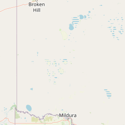
Map view of Mungo National Park

Use this park location map to pinpoint Mungo National Park in Australia, understand its exact geographic position, and read its mapped placement within the surrounding landscape more clearly.

Pigeon | © OpenStreetMap contributors

Location context for Mungo National Park

New South Wales
Natural feature types

Explore the Natural Features and Landforms of Mungo National Park

Continue geographic discovery by browsing the identified natural landmarks, dune systems, and ancient lake features associated with Mungo National Park. MoriAtlas provides a focused look at the physical terrain and landforms of this vast outback protected area, facilitating a deeper understanding of the regional geography and its complex geologic history.
Park atlas

Trace connected protected landscapes and conservation areas within Australia's vast semi-arid outback.

Compare Other National Parks and Protected Areas Near Mungo National Park

Expand your exploration beyond Mungo National Park to discover additional national parks and protected areas across the Willandra Lakes Region and the broader semi-arid landscapes of New South Wales, Australia. Compare their unique ecological features, ancient histories, and conservation efforts to gain a deeper understanding of Australia's diverse protected geography.
National parkNew South Wales
About 52 km away#1 closest

Southwest

Mallee Cliffs National Park: Protected Landscape and Geographic Atlas Entry

Explore its mapped boundaries and regional New South Wales context.

Mallee Cliffs National Park is presented here as a distinct protected landscape, offering specific insights for atlas and geographic discovery. This entry details the park's national park designation and its position within New South Wales, highlighting its mapped boundaries and the surrounding regional geography. It provides the foundational geographic context needed to understand Mallee Cliffs National Park's presence within the broader landscape of protected areas, inviting detailed exploration for those interested in mapped natural terrain.

Area
579.69 km²
Established
1977
IUCN
II
Relief
Lowland
National parkNew South Wales
80 km away#2 closest

Northwest

Kinchega National Park: National Park Protected Area in New South Wales

Explore the mapped Darling River terrain and outback landscapes.

Kinchega National Park stands as a protected national park entity within New South Wales, Australia. Its geographic significance is deeply tied to the Darling River, which shapes its unique riparian ecosystems and contrasts with the surrounding semi-arid outback terrain. This park offers a valuable point for atlas-based discovery, allowing exploration of its mapped boundaries, landscape context, and the conservation of its distinct natural and cultural heritage within the regional geography.

Area
442.59 km²
Established
1967
IUCN
II
Climate
Arid
Biosphere reserveVictoria
About 82 km away#3 closest

Southwest

Hattah-Kulkyne and Murray-Kulkyne Biosphere Reserve: Protected Geography and Mapped Landforms

An inland mosaic of river corridors and semi-arid mallee habitats.

Located in northwestern Victoria, this biosphere reserve encompasses a distinct ecological assembly of Hattah lakes, seasonal floodplains, and sand-ridge terrains. Understand the interplay between the Murray River system and the surrounding dryland vegetation through detailed geographic context.

Area
515 km²
Established
1981
Visitors
99K annual
Relief
Lowland
National parkNew South Wales
83 km away#4 closest

Southeast

Yanga National Park National Park: Mapped Boundaries and Regional Geographic Context in New South Wales

Protected landscape atlas entry for New South Wales.

Examine Yanga National Park, a dedicated national park situated in New South Wales, Australia. This entry provides essential details for atlas-based discovery, focusing on its mapped boundaries, protected area status, and integration into the regional geography. Understanding Yanga National Park contributes to a broader comprehension of protected lands and their distribution, offering a clear geographic perspective on conservation efforts within New South Wales for users seeking structured landscape data.

Area
667.34 km²
Established
2007
IUCN
II
Relief
Lowland
Biosphere reserveNew South Wales
About 84 km away#5 closest

Southwest

Barkindji Biosphere Reserve: Geography and Protected Landscapes in New South Wales

Mapping riverine wetlands and semi-arid dune systems

Barkindji Biosphere Reserve sits within the Murray-Darling Basin, creating a critical conservation area that spans river floodplains, sand plains, and semi-arid forest. This protected entity documents the transition between aquatic river environments and inland dryland terrain, highlighting complex soil and habitat variability across its vast, managed regional footprint.

Area
1,918.23 km²
Established
2005
Visitors
133 annual
Relief
Mixed relief
National parkAustralia
97 km away#6 closest

Southwest

Hattah-Kulkyne National Park: Victoria's Ramsar Wetland National Park & Mallee Landscape

Explore its mapped protected area and semi-arid regional geography.

Delve into Hattah-Kulkyne National Park, a substantial protected area in northwestern Victoria, Australia, defined by its striking red-earth terrain and sprawling mallee woodlands. This national park is renowned for its dynamic seasonal lake system, a key component of the Murray River basin's wetland geography. The park's status as a Ramsar-designated wetland highlights its ecological importance, providing critical habitat within a distinct semi-arid environment. Discover the unique atlas-scale landscape character and protected land context of this significant Australian natural area.

Area
480 km²
Established
1960
IUCN
II
Relief
Lowland
National parkAustralia
104 km away#7 closest

Southwest

Murray-Sunset National Park: Iconic Pink Lakes and Mallee Wilderness in Victoria's Semi-Arid Interior

Explore its unique landscape, mapped boundaries, and regional geography.

Murray-Sunset National Park offers a compelling glimpse into Australia's semi-arid heart, featuring a dramatic landscape of salt lakes, gypsum plains, extensive sand dunes, and dense mallee woodlands. This vast protected area is renowned for the vibrant pink hue of its salt lakes, a phenomenon created by microscopic algae that flourishes in the hypersaline conditions during warmer months. The park's rich biodiversity and unique ecosystem make it a significant conservation asset, providing crucial habitat for numerous species adapted to this challenging yet beautiful environment.

Area
6,330 km²
Established
1991
IUCN
II
Relief
Lowland
Nature reserveNew South Wales
141 km away#8 closest

West

Scotia Sanctuary: Protected Nature Reserve and Mallee Landscape Geography in New South Wales

Arid zone conservation and dune-swale mapping.

Scotia Sanctuary serves as a primary example of arid-zone conservation in south-western New South Wales. This reserve protects vast tracts of intact eucalypt mallee shrubland and sheoak woodland, set across a distinctive landscape of parallel sand dunes and calcareous swales. Its geographic position within the Murray-Darling Depression makes it a critical site for understanding the intersection of land management, habitat restoration, and regional ecological patterns.

Area
650 km²
Established
1994
Relief
Lowland
Climate
Arid

Common questions about visiting, size, designation, and location context for Mungo National Park

Mungo National Park FAQs for park facts, access, geography, and protected area context

Find quick answers about Mungo National Park, including protected-area facts, park geography, trail and visitor context, and how the park fits into its surrounding country and regional landscape.
MoriAtlas Explorer

Continue Your Protected Areas Search Across the Global Atlas

Deepen your exploration by continuing the structured search for national parks and protected areas worldwide. Utilize the comprehensive filtering capabilities to compare different conservation landscapes and refine your understanding of global park geography. Discover more about the distribution and characteristics of protected natural areas.

Global natural geography