Mori Atlas logo
Nature reserveGottesholz

Examining the shell-limestone woodland and ecological boundaries within the Ilm-Kreis district

Gottesholz Nature Reserve: A Detailed Geographic Atlas of a Protected Landscape in Thuringia

(Naturschutzgebiet Gottesholz)

Gottesholz stands as a significant protected nature reserve located on the edge of the Ohrdrufer Platte in the Ilm-Kreis district of central Germany. This detailed map-driven analysis highlights the unique shell-limestone geology and the specific north-facing slope terrain that supports a high concentration of rare, thermophilic plant life. Beyond its role as a strict forest reserve, the area represents a key site for regional botanical study and historical entomological research within the Thuringian landscape.

deciduous mixed forestshell-limestone woodlandnature reservecalcareous florarare orchidsthermophilic woodland

Gottesholz

Nature reserve

Park overview

Structured park overview, official facts, and landscape profile for Gottesholz

Gottesholz park facts, protected area profile, and essential visitor context

Review the core facts for Gottesholz, including designation, size, terrain, visitor scale, habitats, and operating context in one park-focused overview.

About Gottesholz

Gottesholz is a nature reserve in the Ilm-Kreis district of Thuringia, in the central-eastern part of Germany. It lies on the northern margin of the Thuringian Basin landscape, occupying a gentle, north-facing slope on the edge of the Ohrdrufer Platte, between the small village of Espenfeld and the town of Arnstadt. Although compact in size, the reserve has a strong botanical identity rooted in its shell-limestone geology, which produces the warm, well-drained, mineral-rich conditions that many of its rare species require.

In its present form the reserve protects a deciduous mixed forest dominated by oak, hornbeam, and wild service tree (Elsbeere). The forest carries elements of both classic central European mixed broadleaf woodland and more open, thermophilic vegetation patterns. This dual character is the key to its botanical value: typical woodland species grow alongside plants that are more commonly associated with dry grasslands, rocky slopes, or warm continental woodland edges.

Gottesholz has been recognised for its ecological importance since at least the early twentieth century. It was first placed under protection in 1942, given formal forest reserve status in the 1950s, and finally designated as a Naturschutzgebiet in 1961. Within the reserve, part of the area has been set aside as a Totalreservat, a strict observation area where natural forest dynamics can unfold without forestry intervention. Today it functions both as a refuge for rare species and as a long-term reference site for understanding how shell-limestone forests evolve when left largely unmanaged.

Quick facts and research context for Gottesholz

Gottesholz is a protected deciduous mixed forest and Naturschutzgebiet in the Ilm-Kreis district of Thuringia, Germany. It covers roughly 58 hectares, of which a portion is designated as a strict reserve ('Totalreservat') where forestry is excluded. The reserve lies on a north-facing shell-limestone slope of the Ohrdrufer Platte between the villages of Espenfeld and Arnstadt.

Park status: Naturschutzgebiet under the federal/state nature protection framework; IUCN Category IV (Habitat/Species Management Area). Established as a formal nature reserve in 1961, though its protection history stretches back to 1942.

Protection and recognition

Documented conservation status and international recognition data

Gottesholz Protection Status and Official Protected Area Records

Gottesholz holds recorded protected area status within international databases, cataloging formal geographic boundaries and administrative tracking records. Structured conservation metrics outline verified designation details, management frameworks, and baseline protection facts.

Protection details

WDPA ID
163293
Park context

Deeper park guide and search-rich context for Gottesholz

Gottesholz history, landscape, wildlife, and travel context

Explore Gottesholz through its history, landscape character, ecosystems, wildlife, conservation priorities, cultural context, and seasonal travel timing in a structured park guide built for atlas discovery and search intent.

Why Gottesholz stands out

The reserve is best known for its exceptionally rich flora growing on shell-limestone substrate, including the downy oak (Flaumeiche) at the northern edge of its range, the Austrian pleat-seed (Österreichischer Rippensame), and rare orchids such as the lady's slipper orchid (Frauenschuh) and the stately orchid (Stattliches Knabenkraut). It also has a generally warm, semi-open woodland character that supports both forest plants and more thermophilic, open-ground species. The site has further historical importance as the place where the weevil species Querbinden-Holzrüssler (Acalles hypocritus) was first discovered in 1837.
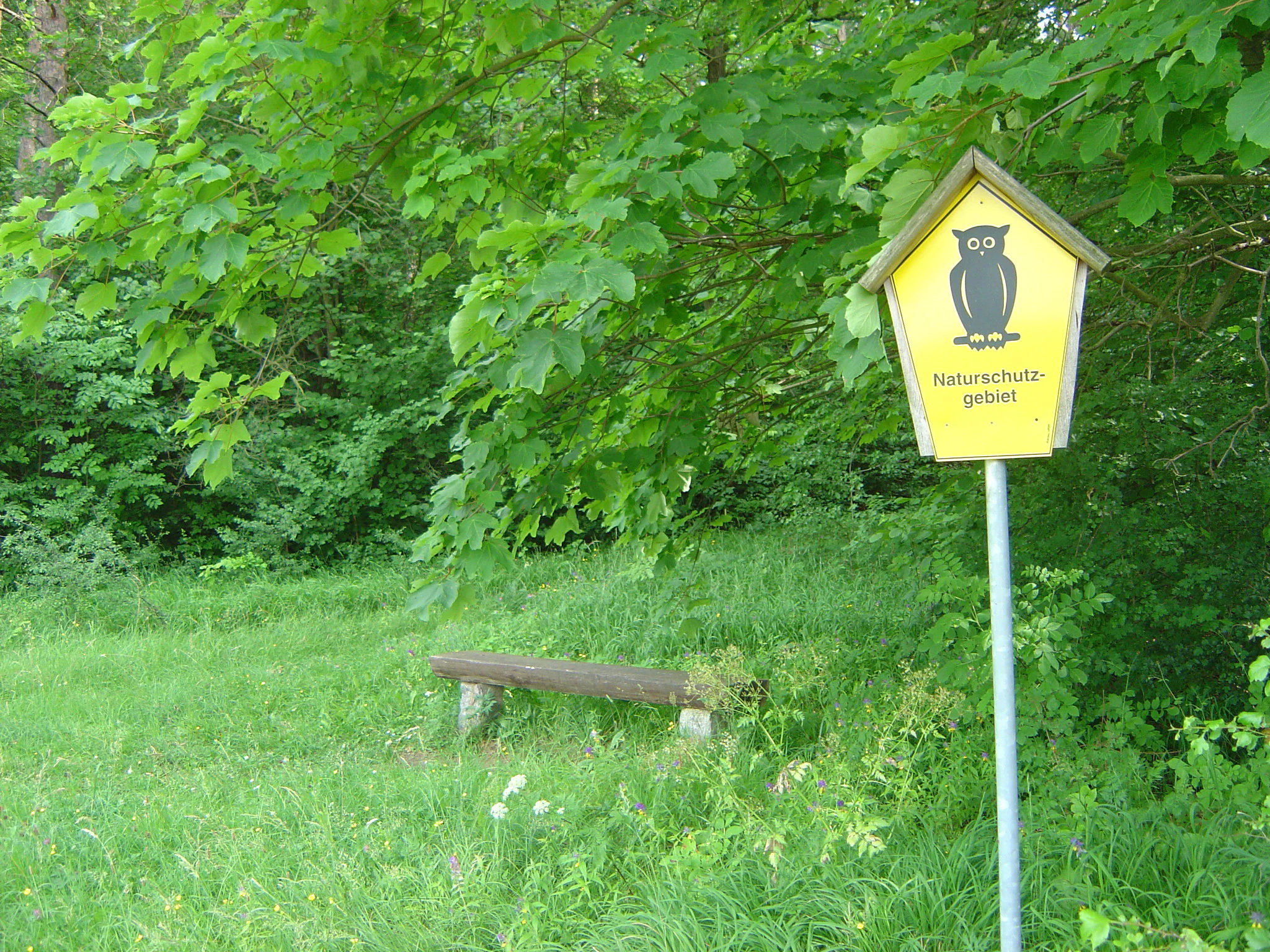
A yellow, house-shaped nature reserve sign with an owl icon and the text Naturschutzgebiet, standing on a pole in front of a forest with a wooden bench nearby.
A nature reserve sign featuring a stylized owl emblem, marking the entrance to the Gottesholz area.

Gottesholz history and protected-area timeline

Before becoming a nature reserve, Gottesholz was used as a working forest for centuries. In earlier periods it was managed as a coppice or "Niederwald," a low-stem woodland harvested on short rotations, and later as a "Mittelwald," a middle-forest system that combines coppice areas with scattered standard trees. These traditional woodland uses shaped the structure of the forest and helped maintain an open character that supported diverse ground vegetation.

Its exceptional biodiversity was noticed in the early twentieth century, and on 12 August 1942 the site was first placed under protection, covering about 49 hectares. In 1957, the council of the Bezirk Erfurt elevated its designation to a formal forest protection area ("Waldschutzgebiet"). The following years saw further tightening of its protected status: in 1959 a strict reserve of nearly 30 hectares was carved out, and on 30 March 1961 the site was officially designated as a Naturschutzgebiet covering roughly 59.27 hectares.

The site's contribution to natural history extends beyond its legal protection. The weevil species Acalles hypocritus (Querbinden-Holzrüssler) was scientifically described from specimens collected at Gottesholz in 1837, giving the forest a small but notable place in nineteenth-century European entomology.

Gottesholz landscape and geographic character

Gottesholz occupies a moderately sloping, north-facing hillside on the western edge of the Ohrdrufer Platte, a broad plateau region in central Thuringia. The reserve sits between roughly 390 and 451 metres above sea level, an elevation band that, together with its slope aspect, creates a specific microclimate on the slope's different exposures.

The defining physical feature of the site is its shell-limestone (Muschelkalk) geology. Beds of Schaumkalk, a coarse, porous limestone, are partly exposed at the surface and reach thicknesses of up to about six metres. This rocky, calcareous substrate weathers into thin, mineral-rich soils, which in turn support a distinctive vegetation pattern. Although the terrain itself is modest and not visually dramatic, the combination of plateau edge, slope, and calcareous bedrock gives Gottesholz its ecological character.

Gottesholz ecosystems, habitats, and plant life

The reserve's vegetation reflects its shell-limestone soils and warm microclimate. The forest canopy is dominated by oak, hornbeam, and wild service tree (Elsbeere), a species mix that creates a varied light regime under which both shade-tolerant woodland herbs and more light-demanding plants can coexist.

Gottesholz's botanical importance is unusually high for such a small site. Surveys have recorded eleven Red List species, including the downy oak (Flaumeiche) at the northern edge of its natural distribution; the Austrian pleat-seed (Österreichischer Rippensame); various characteristic herbs such as mountain reed grass (Berg-Reitgras), the various-leaved vetchling (Verschiedenblättrige Platterbse), the long-leaved hare's ear (Langblättriges Hasenohr), and the clustered bellflower (Knäuel-Glockenblume); and rare orchids including the lady's slipper (Frauenschuh) and the stately orchid (Stattliches Knabenkraut). The mix of forest species and thermophilic, open-ground species gives the site a transitional ecosystem character that has long attracted botanical interest.

Gottesholz wildlife and species highlights

The animal life of Gottesholz has attracted considerable attention, with the reserve noted both for its species richness and for the presence of threatened taxa. A particular point of interest is entomological: in 1837 the weevil Acalles hypocritus (Querbinden-Holzrüssler) was first described from specimens collected in the forest, giving the site a documented role in the history of European beetle taxonomy.

Beyond this specific record, Gottesholz's combination of mature broadleaf canopy, deadwood, open rocky patches, and warm microclimates supports a wide range of insects and other invertebrates, which in turn underpin populations of birds and small woodland mammals. The mix of habitats kept inside the reserve, including both strict forest and less intensively managed edges, allows animal communities associated with mature deciduous woodland to thrive alongside those favoured by open-structured or thermophilic conditions.

Gottesholz conservation status and protection priorities

Gottesholz is a Naturschutzgebiet under Thuringian and German nature protection law, classified internationally as IUCN Category IV (Habitat/Species Management Area). The reserve's conservation value rests less on its size than on the high concentration of rare and Red List species it supports within a small area, many of them associated with calcareous woodland and warm, semi-open habitats.

A distinctive feature of its conservation management is the inclusion of a Totalreservat, a strict no-intervention area where forestry and active habitat management are excluded. This zone functions as a reference site, allowing natural processes such as natural tree regeneration, deadwood accumulation, and gradual canopy change to proceed. Used together with traditional protected-area status, this dual approach recognises both the site's existing biodiversity value and its importance for understanding long-term forest dynamics on shell-limestone substrates.

Gottesholz cultural meaning and human context

Gottesholz's human history is primarily a history of woodland use. For centuries the forest was managed as a working forest, first as a coppice (Niederwald) and later as a middle-forest (Mittelwald) system. These management regimes shaped the forest's open, multi-layered structure, in turn helping maintain the rich ground flora that later attracted conservation attention.

The fact that the reserve lies between the village of Espenfeld and the larger town of Arnstadt also places it within a wider Thuringian landscape that has a long tradition of forest use, small-scale agriculture, and local natural-history scholarship. The early nineteenth-century description of the beetle Acalles hypocritus from the site fits within that broader regional tradition of careful natural-history observation.

Top sights and standout views in Gottesholz

Among Gottesholz's standout qualities are its shell-limestone geology, which produces the calcareous soils underpinning its flora, and the unusually high plant diversity compressed into a small area. The combination of woodland species with thermophilic, open-ground species gives the reserve a distinctive ecological character.

The presence of a strict no-intervention reserve within the area, the documented Red List species list, and the site's place in nineteenth-century entomology through the discovery of the weevil Acalles hypocritus add further layers of interest, making Gottesholz a notable site both for nature conservation and for the history of regional natural science.

Best time to visit Gottesholz

Gottesholz is most rewarding in late spring and early summer, when both the woodland ground flora and the orchid populations, including the lady's slipper and the stately orchid, are in flower. Late spring is typically the best window to see the reserve's full botanical display.

Autumn can also be worthwhile for visitors interested in forest structure, woodland mushrooms, and the general character of the native oak and hornbeam canopy. In winter, the open structure of the formerly coppiced woodland is more visible, providing a different perspective on the forest's history and the role of its traditional management in shaping the present landscape.

Monthly climate preview

Long term temperature and precipitation patterns across representative Ilm-Kreis terrain coordinates

Gottesholz Climate Normals and Average Temperature Rhythm

Representative coordinate records outline the annual temperature progression and monthly precipitation averages for Gottesholz across a multi-decade baseline. Examining the full twelve-month profile provides complete monthly climate data and detailed weather records for the protected area.
Annual mean8 °C
-1 °C18 °C
Jan-1°
Feb
Mar
Apr
May12°
Jun16°
Jul18°
Aug18°
Sep14°
Oct
Nov
Dec
Warmest month
July

18.4 °C

Coolest month
January

-1.3 °C

Wettest month
July

2.6 mm/day

Driest month
April

1.4 mm/day

Park location guide

Geography guide, regional context, and park location map for Gottesholz

Gottesholz park geography, regions, and map view in Germany

Understand where Gottesholz sits in Germany through a broader geographic reading of the surrounding landscape, nearby location context, and its mapped position within the national park landscape.

How Gottesholz fits into Germany

Germany is a federal republic in Western and Central Europe with a population of over 83 million across sixteen constituent states. It is Europe's largest economy by nominal GDP and a major global exporter and importer. The capital is Berlin, and the country borders Denmark, Poland, Czech Republic, Austria, Switzerland, France, Luxembourg, Belgium, and the Netherlands.

Wider geography shaping Gottesholz in Germany

Germany is located in Western and Central Europe, spanning 357,022 km². It borders Denmark to the north, Poland and the Czech Republic to the east, Austria and Switzerland to the south, and France, Luxembourg, Belgium, and the Netherlands to the west. The country has coastlines on the Baltic Sea and North Sea to the north, with the Alps located in the southern region.

Map view of Gottesholz

Use this park location map to pinpoint Gottesholz in Germany, understand its exact geographic position, and read its mapped placement within the surrounding landscape more clearly.

Pigeon | © OpenStreetMap contributors

Location context for Gottesholz

Ilm-KreisThuringia

Explore detailed imagery of shell limestone terrain, woodland habitats, and rare flora across the Thuringian reserve.

Gottesholz Photos and Landscape Scenery: Visualizing the Protected Forest Environment

Visual documentation of Gottesholz reveals the underlying shell limestone terrain, mixed deciduous woodland, and specialized calcareous flora defining the protected reserve. Examining these landscape views and habitat conditions provides a clearer understanding of the ecological character found across the Thuringian plateau.

A yellow, house-shaped nature reserve sign with an owl icon and the text Naturschutzgebiet, standing on a pole in front of a forest with a wooden bench nearby.

Park atlas

Discover connected woodland reserves and regional protected landscapes across central Thuringia

Explore Protected Areas and Nearby Parks Around Gottesholz

Compare adjacent protected areas and neighboring nature reserves after reviewing the ecological profile of Gottesholz. Examining surrounding regional parks provides broader geographic context for central German forest ecosystems and limestone terrains.
Nature reserveThuringia
About 8.5 km away#1 closest

South

Veronikaberg Nature Reserve: Protected Muschelkalk Ridge and Forest Landscapes in Thuringia

Geographic overview of the southern Reinsberge range.

Veronikaberg functions as a critical nature reserve at the southeastern edge of the Ohrdrufer Platte. The landscape is defined by its Muschelkalk geology, which supports a unique microclimate for beech and yew forests. This record details the park boundaries and the terrain transitions that characterize this significant conservation site in central Germany.

Area
1.161 km²
Established
1961
Relief
Mountain
Water
No major water
Nature reserveThuringia
About 9.2 km away#2 closest

Southeast

Willinger Berg Nature Reserve: Exploring the Geography and Forested Terrain of the Ilm-Saale-Platte

A prominent muschelkalk limestone outlier in Thuringia

Willinger Berg stands out for its double-peaked silhouette and geological significance as a Zeugenberg. The 83.8 hectare nature reserve includes protected beech forests and karst features that define the slopes above the surrounding villages. This study traces its role as a regional landmark and its position within the complex watershed of the Ilm and Unstrut basins.

Area
0.838 km²
Relief
Mountain
Climate
Temperate
Scope
Terrestrial
Nature reserveThuringia
About 12 km away#3 closest

East

Hohes Kreuz Nature Reserve: Mapping Forest Conservation in the Ilm District of Thuringia

A preserved oak-hornbeam landscape within the central German agricultural mosaic.

Hohes Kreuz is a protected nature reserve in Thuringia, Germany, renowned for preserving a residual oak-hornbeam forest on a Muschelkalk plateau. The site functions as an ecological refuge, supporting a wide variety of bird species and broadleaf vegetation while providing a striking contrast to the surrounding farmland of the Ilm district.

Area
0.105 km²
Established
1961
IUCN
IV
Relief
Upland
A soft watercolor illustration of a pond landscape with green reeds in the foreground, calm water in the midground, and distant rolling hills in the background.
Nature reserveIlm-Kreis
About 13 km away#4 closest

South

Ilmenauer Teichgebiet: Wetland Landscape and Protected Nature Reserve Atlas

Mapped pond system and geographic terrain in Ilm-Kreis

The Ilmenauer Teichgebiet nature reserve is defined by its six interconnected ponds, which create a significant wetland complex on the eastern edge of Ilmenau. Anchored by the Grosser Teich and supported by a gypsum basin, this area preserves both the history of medieval fish farming and critical habitats for waterbirds and amphibians, offering a unique look at the regional geography of central Thuringia.

Area
0.58 km²
Established
2002
IUCN
IV
Relief
Lowland
A horizontal watercolor painting showing a green marshy landscape with a small winding stream, wildflowers in the foreground, and soft rolling hills in the background.
Nature reserveThuringia
About 17 km away#5 closest

Northwest

Siebleber Teich Nature Reserve: A Detailed Map of Thuringia's Historic Wetland Landscape

Exploring the ecology and cultural geography of a protected lowland fishpond

Siebleber Teich in Thuringia represents a unique convergence of late glacial wetland history and centuries of ducal pond management. This nature reserve protects a shallow aquatic environment surrounded by levees, mature linden trees, and marshes. It stands as a crucial geographic anchor for avian and amphibian populations within the Gotha district, showcasing how managed land evolves into a protected wildlife sanctuary.

Area
0.28 km²
Established
1717
Relief
Lowland
Climate
Temperate
A horizontal watercolor painting depicting a landscape with soft, rolling hills in the background, a band of mixed forest with hints of autumn foliage in the midground, and a winding stream flowing through wetland grasses in the foreground.
Nature reserveThuringia
About 18 km away#6 closest

Southeast

Pennewitzer Teiche und Unteres Wohlrosetal Nature Reserve: Thuringian Wetland Geography

A dense mosaic of historic ponds, moor woodlands, and framing stream valleys.

Located in Thuringia, this nature reserve is defined by an extraordinary density of aquatic habitats. The terrain features historic pond groups and flooded forest pits linked by brook valleys. This protected area serves as an essential example of the interplay between cultural pond construction and natural wetland ecosystems in central Germany.

Area
4.246 km²
Established
2004
IUCN
IV
Nature reserveThuringia
About 18 km away#7 closest

Southwest

Saukopfmoor Nature Reserve: A Protected Raised Bog in Thuringia, Germany

Mapping peatland ecosystems within the Thuringian Forest

Saukopfmoor functions as a managed nature reserve in the Thuringian Forest, protecting valuable raised bog habitat that relies on specific high-elevation conditions. This site stands as a key example of peatland conservation in central Germany, revealing how stable mountain microclimates sustain specialized flora and complex hydrological processes across the regional landscape.

Area
0.346 km²
Established
1961
IUCN
IV
Climate
Temperate
A soft watercolor illustration of a bog landscape featuring layers of green coniferous trees, a flat horizon, and distant, faint pink hills against a white background.
Nature reserveThuringia
About 19 km away#8 closest

Southwest

Schützenbergmoor Nature Reserve: Highland Bog Landscape in Thuringia, Germany

Examining protected wetland terrain and bog ecology

Schützenbergmoor is an essential protected area for understanding highland raised bog ecosystems in the Thuringian Forest. This small, high-altitude site illustrates the intersection of peatland formation and cool, moist regional geography, offering a window into the specialized wetland terrain and microclimates that define this protected landscape in central Germany.

Area
0.052 km²
Established
1967
Relief
Upland
Climate
Temperate

Common questions about visiting, size, designation, and location context for Gottesholz

Gottesholz FAQs for park facts, access, geography, and protected area context

Find quick answers about Gottesholz, including protected-area facts, park geography, trail and visitor context, and how the park fits into its surrounding country and regional landscape.
MoriAtlas Explorer

Continue Your Protected Areas Search Across the Global Atlas

Deepen your exploration by continuing the structured search for national parks and protected areas worldwide. Utilize the comprehensive filtering capabilities to compare different conservation landscapes and refine your understanding of global park geography. Discover more about the distribution and characteristics of protected natural areas.

Global natural geography