

Mori Atlas logo
Nature reserveGräbenwäldchesfeld von Hausen

Analyzing the mapped boundaries and ecological terrain of this rare regional habitat

Gräbenwäldchesfeld von Hausen: Protected Nature Reserve and Hessian Wetland Landscape Atlas

(Naturschutzgebiet Gräbenwäldchesfeld von Hausen)

Gräbenwäldchesfeld von Hausen represents a vital protected landscape fragment situated in the state of Hessen. This nature reserve preserves a mosaic of wet meadows, reed beds, and large sedge communities that provide essential habitat within the intensively developed Rhine-Main metropolitan geography. The site remains a key indicator of relict moisture-dependent ecosystems, highlighting the importance of managed grassland boundaries in maintaining regional biodiversity.

wet meadowreed bedwetlandorchidshabitat managementIUCN Category IV

Gräbenwäldchesfeld von Hausen

Nature reserve

Park overview

Structured park overview, official facts, and landscape profile for Gräbenwäldchesfeld von Hausen

Gräbenwäldchesfeld von Hausen park facts, protected area profile, and essential visitor context

Review the core facts for Gräbenwäldchesfeld von Hausen, including designation, size, terrain, visitor scale, habitats, and operating context in one park-focused overview.

About Gräbenwäldchesfeld von Hausen

Gräbenwäldchesfeld von Hausen is a small, ecologically focused nature reserve in the southern part of the Rhine-Main region of Germany. Despite its modest extent of around 5.4 hectares, it represents a meaningful fragment of the species-rich wet meadow landscape that once characterized parts of the Hessian lowlands around Obertshausen and that has been widely lost to agricultural intensification and urban development.

Administratively the site falls within the Landkreis Offenbach in Hesse, and within the town boundaries of Obertshausen, specifically on the southeastern edge of the town in the locality of Hausen. Its designation as a Naturschutzgebiet places it under the formal German nature conservation framework, with management responsibility held by the lower nature conservation authority (Untere Naturschutzbehörde) of the district.

Internationally the reserve is classified in the World Database on Protected Areas under IUCN Category IV, recognizing it as a Habitat/Species Management Area. This classification reflects its role as a working landscape in which active management, generally including traditional mowing regimes, is needed to sustain the targeted meadow and wetland habitats and the species they support.

In the broader context of the Landkreis Offenbach, Gräbenwäldchesfeld von Hausen is one of more than thirty Naturschutzgebiete, forming part of a network that includes wet forest fragments, gravel pit lakes, river floodplain meadows, and other wetland habitats. Within that network this reserve contributes a specific niche: a small, traditionally managed wet meadow complex that retains tangible botanical diversity in a densely populated region.

Quick facts and research context for Gräbenwäldchesfeld von Hausen

Gräbenwäldchesfeld von Hausen is a Hessian nature reserve (NSG) covering approximately 5.4 hectares within the town of Obertshausen, Landkreis Offenbach. Designated in 1990 and identified by NSG number 1438017 and WDPA ID 163294, it is managed by the lower nature conservation authority of the Offenbach district.

The reserve's protective focus is on species-rich wet meadows (Feuchtwiesen), reed beds (Röhrichte), and large-sedge marsh communities (Großseggenriede), habitats that host several regionally rare plant species, including two Dactylorhiza orchids and moisture-loving species such as adder's tongue, marsh cinquefoil, and marsh violet.

Protection and recognition

Documented terrestrial protection metrics and official administrative scope

Gräbenwäldchesfeld von Hausen Protection Status and Recognition Data

Terrestrial protection status records detail the official conservation boundaries and administrative context established for Gräbenwäldchesfeld von Hausen. Structured data parameters outline the recorded management framework without implying unverified international recognitions.

Protection details

Protection scope
Terrestrial
Transboundary protection
No
WDPA ID
163294
Park context

Deeper park guide and search-rich context for Gräbenwäldchesfeld von Hausen

Gräbenwäldchesfeld von Hausen history, landscape, wildlife, and travel context

Explore Gräbenwäldchesfeld von Hausen through its history, landscape character, ecosystems, wildlife, conservation priorities, cultural context, and seasonal travel timing in a structured park guide built for atlas discovery and search intent.

Why Gräbenwäldchesfeld von Hausen stands out

The reserve is known above all for its species-rich wet meadow vegetation, in particular the presence of nationally and regionally notable orchids including the broad-leaved marsh orchid (Dactylorhiza majalis) and the heath spotted orchid (Dactylorhiza maculata). Its protected status is tied explicitly to maintaining these wet meadow, reed bed, and large-sedge communities with their rare flora and fauna.
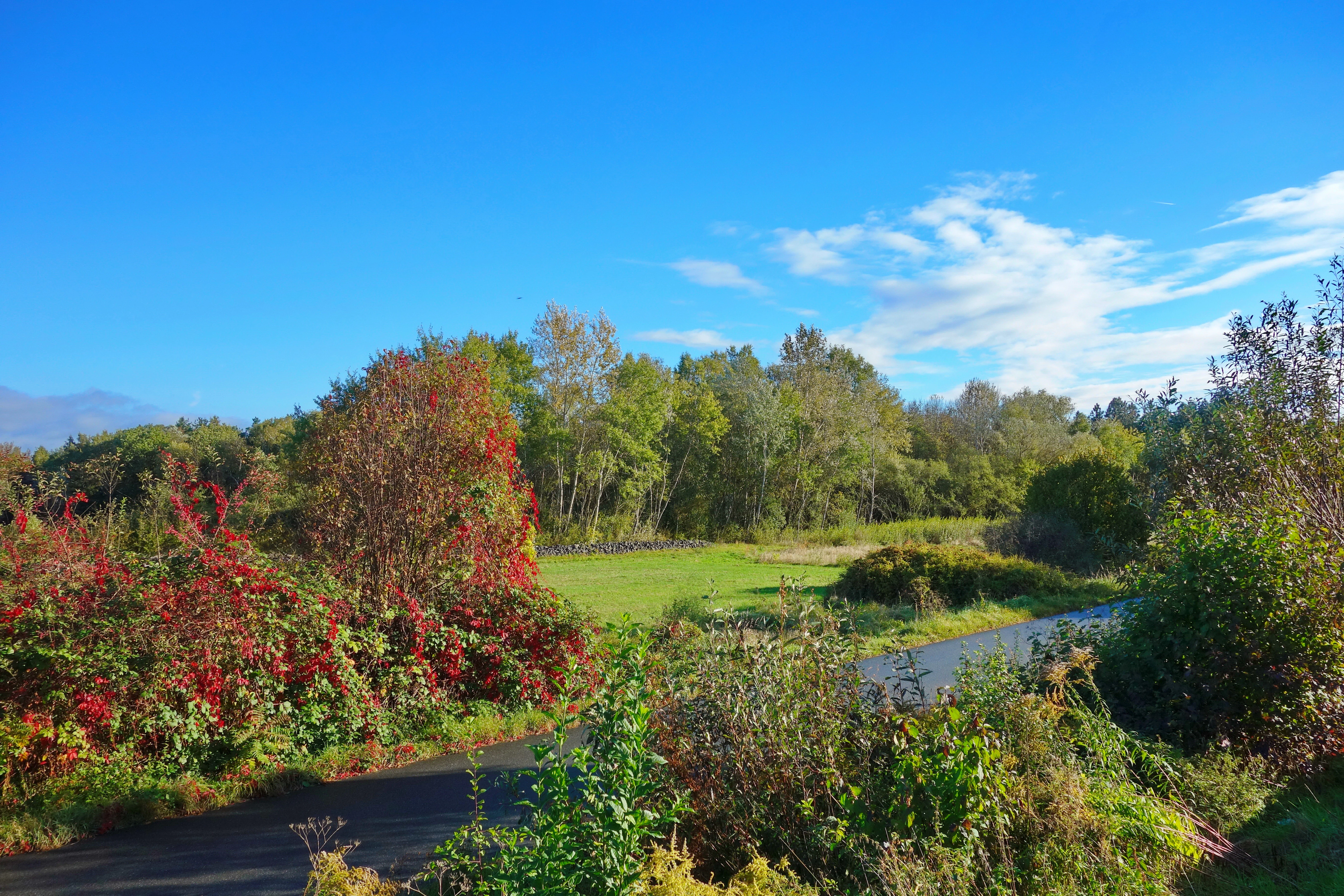
A paved path curves through a grassy meadow bordered by trees and shrubs with red and green leaves under a bright blue sky with scattered clouds.
A paved path winds through a green meadow surrounded by trees and bushes with autumn foliage under a blue sky.

Gräbenwäldchesfeld von Hausen history and protected-area timeline

The area was formally designated as a Naturschutzgebiet in 1990, becoming part of the Hessian register of protected sites under the designation number 1438017. The reserve's establishment reflected growing recognition of the conservation value of the remaining wet meadow habitat on the southeastern edge of Obertshausen and an effort to safeguard its botanical diversity and associated fauna through managed protection.

Since its designation, the area has continued to be administered under Hessian nature conservation law and managed by the lower nature conservation authority of the Kreis Offenbach, with its profile later incorporated into the World Database on Protected Areas under WDPA ID 163294. The 1990 designation placed the area permanently within the broader inventory of protected meadow and wetland sites of the Landkreis Offenbach.

Gräbenwäldchesfeld von Hausen landscape and geographic character

The reserve lies on the southeastern margin of the town of Obertshausen and is a flat, low-lying landscape element typical of the Hessian lowland fringe south of the Main river. Although there are no dramatic topographical features, the micro-relief and hydrology of the site are essential to its ecological character: the terrain supports the waterlogged soils that sustain the wet meadow and sedge communities at the heart of the reserve's identity.

The site is a small open area within a predominantly urban and agricultural setting. The contrast between the protected meadow and its surroundings underscores how isolated such habitat fragments have become within the Rhine-Main metropolitan region, where built-up areas and intensive farmland dominate the immediate landscape matrix.

Gräbenwäldchesfeld von Hausen ecosystems, habitats, and plant life

Ecologically the reserve is defined by its semi-natural grassland and wetland vegetation. Its core habitat types are species-rich wet meadows (Feuchtwiesen), reed beds (Röhrichte), and large-sedge marsh (Großseggenriede), all of which depend on consistent soil moisture and on traditional management regimes that prevent woody encroachment and nutrient enrichment.

Among the recorded plant species are several regionally notable moisture-dependent taxa, including the broad-leaved marsh orchid and the heath spotted orchid, alongside adder's tongue fern (Ophioglossum), marsh cinquefoil (Potentilla palustris), and marsh violet (Viola palustris). The combination of orchids and characteristic wetland flora gives the site a botanical profile that stands out clearly against the more intensively used agricultural and urban surroundings.

Gräbenwäldchesfeld von Hausen wildlife and species highlights

Wildlife information in the available sources is general rather than species-specific, but the reserve's official protective purpose explicitly references the rare animal species associated with its wet meadows, reed beds, and large-sedge communities. Such habitat mosaics typically support invertebrates specialized on wet grassland, amphibians using the saturated soils and shallow water zones, and a range of wetland-associated bird and small mammal species that use the dense vegetation structure for foraging and cover.

The combination of open meadow, reed, and sedge vegetation at the site, even on a footprint of just a few hectares, makes it a functionally meaningful refuge for the moisture-dependent fauna of the surrounding lowlands.

Gräbenwäldchesfeld von Hausen conservation status and protection priorities

Conservation value lies in the reserve's role as a protected refuge for a specific suite of wet meadow and wetland habitats that have become rare in the Hessian lowlands around the Rhine-Main conurbation. The formal Schutzzweck (conservation objective) is explicitly to preserve and secure the species-rich wet meadows, reed beds, and large-sedge marsh with their rare flora and fauna, indicating that maintenance of the open, moist vegetation structure is itself the central conservation goal.

The site's inclusion in the Landkreis Offenbach network of Naturschutzgebiete and its international recognition in the World Database on Protected Areas underline its standing within the German and European protected-area systems. At the landscape scale, the reserve contributes to the persistence of habitat connectivity among the remaining meadow and wetland fragments in the district, even where individual sites are small.

Gräbenwäldchesfeld von Hausen cultural meaning and human context

The locality name 'Hausen' refers to a traditional settlement area within Obertshausen, and the meadow itself is a long-standing element of the local cultural landscape. Wet meadows of this kind are intimately linked to traditional, low-intensity agricultural practices, and their survival within the town area reflects the continuation of long-established land-use patterns that shaped the rural backdrop of what is now a suburban municipality south of Frankfurt.

Top sights and standout views in Gräbenwäldchesfeld von Hausen

The reserve's standout features are its species-rich wet meadow vegetation, its orchid flora including Dactylorhiza majalis and Dactylorhiza maculata, and its protected mosaic of reed bed and large-sedge marsh habitats. Its compact size reinforces rather than diminishes its value, as each hectare supports a concentrated expression of the wet grassland habitats that have largely disappeared from the surrounding Rhine-Main landscape.

Best time to visit Gräbenwäldchesfeld von Hausen

The best period to experience the reserve is during the growing season of its wet meadows, when the characteristic vegetation is most visible. Late spring through early summer is generally when the orchid species flower and the wetland flora is at its most expressive, while summer offers more developed reed and sedge growth. As the site is a protected nature reserve, visits are typically limited to observation from the perimeter rather than entry, so timing is primarily relevant for those interested in viewing the meadow from accessible viewpoints in the surrounding area.

Monthly climate preview

Long-term representative point measurements tracking monthly temperature and precipitation rhythms in Hessen

Gräbenwäldchesfeld von Hausen Climate Normals and Annual Weather Patterns

Representative coordinate records show measured monthly temperature variations spanning from sub-zero winter minimums to warm summer maximums alongside steady year-round precipitation averages. Accessing the complete twelve-month climatology dataset provides deeper analytical insight into the specific baseline normals established for this protected location.
Annual mean10 °C
0 °C21 °C
Jan
Feb
Mar
Apr10°
May14°
Jun18°
Jul21°
Aug20°
Sep15°
Oct10°
Nov
Dec
Warmest month
July

20.6 °C

Coolest month
January

0.2 °C

Wettest month
July

2.2 mm/day

Driest month
April

1.4 mm/day

Park location guide

Geography guide, regional context, and park location map for Gräbenwäldchesfeld von Hausen

Gräbenwäldchesfeld von Hausen park geography, regions, and map view in Germany

Understand where Gräbenwäldchesfeld von Hausen sits in Germany through a broader geographic reading of the surrounding landscape, nearby location context, and its mapped position within the national park landscape.

How Gräbenwäldchesfeld von Hausen fits into Germany

Germany is a federal republic in Western and Central Europe with a population of over 83 million across sixteen constituent states. It is Europe's largest economy by nominal GDP and a major global exporter and importer. The capital is Berlin, and the country borders Denmark, Poland, Czech Republic, Austria, Switzerland, France, Luxembourg, Belgium, and the Netherlands.

Wider geography shaping Gräbenwäldchesfeld von Hausen in Germany

Germany is located in Western and Central Europe, spanning 357,022 km². It borders Denmark to the north, Poland and the Czech Republic to the east, Austria and Switzerland to the south, and France, Luxembourg, Belgium, and the Netherlands to the west. The country has coastlines on the Baltic Sea and North Sea to the north, with the Alps located in the southern region.

Map view of Gräbenwäldchesfeld von Hausen

Use this park location map to pinpoint Gräbenwäldchesfeld von Hausen in Germany, understand its exact geographic position, and read its mapped placement within the surrounding landscape more clearly.

Pigeon | © OpenStreetMap contributors

Location context for Gräbenwäldchesfeld von Hausen

Hessen

Visualizing the rare wet meadows, sedge communities, and lowland marsh habitats of Hesse

Gräbenwäldchesfeld von Hausen Photos and Protected Landscape Scenery

Photographic records reveal the distinct flat terrain, waterlogged soils, and specialized flora that define Gräbenwäldchesfeld von Hausen. Examining these protected habitats provides clear insight into regional wetland conservation and relict grassland ecosystems.

A paved path curves through a grassy meadow bordered by trees and shrubs with red and green leaves under a bright blue sky with scattered clouds.

Park atlas

Discover related wetland fragments and connected nature reserves across the surrounding region.

Exploring Parks Near Gräbenwäldchesfeld von Hausen in Regional Protected Landscapes

Browse protected areas near Gräbenwäldchesfeld von Hausen to examine similar wet meadow habitats and regional conservation networks. Comparing adjacent reserves reveals the broader ecological context of the surrounding Hessian lowland landscape.
Nature reserveHesse
About 2.1 km away#1 closest

Southwest

Im Woog von Hainstadt Nature Reserve: Regional Geography and Protected Landscape Atlas

Mapping floodplain habitats in the Lower Main plain of Hesse

Im Woog von Hainstadt is a structurally diverse nature reserve located in Hainstadt, Germany. The site protects a compact floodplain mosaic consisting of deciduous woodland, wet meadows, and dry grasslands on a former river meander. Adjacent to the Wildpark Alte Fasanerie, the reserve functions as a biodiversity hotspot, offering essential habitat within the developed eastern Lower Main plain landscape.

Area
0.142 km²
Established
1992
Relief
Lowland
Climate
Temperate
Nature reserveHesse
About 2.6 km away#2 closest

Northeast

Lauternsee bei Klein-Auheim Nature Reserve: Geography and Protected Bog Landscape

A historic high terrace habitat within the Hesse woodland region.

Lauternsee bei Klein-Auheim represents a specialized Flachmoor habitat that emerged from a former river channel of the Main. This nature reserve serves as an important ecological anchor in the lower Main valley, protecting essential wetlands, amphibian populations, and unique marsh plant communities within an expansive forest setting.

Established
1987
Nature reserveLandkreis Offenbach
About 3.3 km away#3 closest

North

Mayengewann von Lämmerspiel: Nature Reserve and Protected Landscape in Landkreis Offenbach

Oak woodlands and rare orchid meadows within the Rhine-Main landscape

Examine the geography of Mayengewann von Lämmerspiel, a significant nature reserve characterized by its mosaic of old oak forest and moist grassland. This site acts as an ecological refuge in Landkreis Offenbach, safeguarding rare species such as the fen violet, adder's-tongue fern, and multiple orchid varieties within a carefully managed protected boundary.

Area
0.067 km²
Established
1985
IUCN
IV
Relief
Lowland
Nature reserveHessen
About 3.8 km away#4 closest

North

Amerikafeld und Schindkaute bei Steinheim: Nature Reserve and Protected Grassland Map

Rare sand dry grassland habitat within the Hessen metropolitan region.

Amerikafeld und Schindkaute bei Steinheim is a protected nature reserve in Hanau that shelters scarce sand dry grasslands. The terrain, defined by ice-age sandy deposits, remains an important ecological island, maintaining an open steppe-like character through historic grazing practices in a landscape otherwise dominated by urban growth.

Area
16 km²
Established
1995
Nature reserveHessen
About 5 km away#5 closest

North

Oberwaldsee von Dietesheim Nature Reserve: Atlas and Geographic Landscape Overview

Protected basalt terrain in the Hessen region

Discover the geographic character of Oberwaldsee von Dietesheim, a protected nature reserve in Hessen defined by flooded basalt quarries and open sandy dry-grassland. This site serves as a vital ecological stepping stone within the Untermain lowlands, offering a study in microtopography and habitat diversity. Access detailed mapping and protected-area context for this essential German nature reserve within the Rhine-Main metropolitan corridor.

Area
0.335 km²
Established
1989
IUCN
IV
Nature reserveHessen
About 5 km away#6 closest

West

Erlensteg von Bieber Nature Reserve: Geographic Map and Protected Habitat Overview

Compact wetland and forest mosaic in the Hessen region

Erlensteg von Bieber preserves a rare concentration of habitat types within a small footprint. From its moist floodplain meadows and sedge wetlands to its drier forest glades and fallow fields, this reserve showcases vital conservation management in the Rhine-Main area of Germany.

Area
0.752 km²
Established
1996
IUCN
IV
Nature reserveLandkreis Offenbach
About 5.2 km away#7 closest

Southeast

Kortenbach bei Froschhausen Nature Reserve: Geographic Mapping and Protected Forest Overview

Hardwood floodplain woodland in Landkreis Offenbach

Kortenbach bei Froschhausen protects a compact, groundwater-influenced forest ecosystem within the Offenbach district. This nature reserve acts as a critical refuge for mature broadleaf trees, including the rare European white elm. Our atlas entry focuses on the site's stream-fed terrain and its role as a preserved forest fragment amidst surrounding agricultural and transport infrastructure.

Area
0.405 km²
Established
1998
IUCN
IV
Nature reserveHessen
About 5.8 km away#8 closest

East

Pechgraben bei Klein-Krotzenburg Nature Reserve in the Hessen Protected Landscape Network

A preserved mosaic of ancient floodplain terrain and wetland habitats.

Located in the Offenbach district, this nature reserve protects a rare post-glacial flood channel of the Main river. The site exhibits a diverse landform mosaic, ranging from near-natural broadleaf forests to expansive sedge marshes. It functions as a critical protected geography for regional species, maintaining its ecological character against the surrounding agricultural and residential development of the Lower Main valley.

Area
0.341 km²
Established
1998
IUCN
IV
Relief
Lowland

Common questions about visiting, size, designation, and location context for Gräbenwäldchesfeld von Hausen

Gräbenwäldchesfeld von Hausen FAQs for park facts, access, geography, and protected area context

Find quick answers about Gräbenwäldchesfeld von Hausen, including protected-area facts, park geography, trail and visitor context, and how the park fits into its surrounding country and regional landscape.
MoriAtlas Explorer

Continue Your Protected Areas Search Across the Global Atlas

Deepen your exploration by continuing the structured search for national parks and protected areas worldwide. Utilize the comprehensive filtering capabilities to compare different conservation landscapes and refine your understanding of global park geography. Discover more about the distribution and characteristics of protected natural areas.

Global natural geography