
Mori Atlas logo
Nature reserveGrabsche Berge

A study of steppe-like slopes, geological cuesta formations, and dry grassland habitats

Grabsche Berge Nature Reserve: Mapping the Protected Keuper Hill Landscapes of Central Thuringia

(Naturschutzgebiet Grabsche Berge)

Grabsche Berge represents a significant protected landscape on the northwestern margin of the Thuringian Basin. This compact nature reserve features a distinct cuesta chain rising above the Notter valley, defined by gypsum-influenced Middle Keuper sediments. The site offers a detailed look at xerothermic habitats that thrive in this transition zone, contrasting sharply with the surrounding agricultural lowlands of the Mühlhausen district.

nature reservedry grasslandsteppe slopeskeuper hillsThuringian Basincuesta landscape
A stylized vector illustration of a scenic valley with a foreground of wildflowers and tall grasses, transitioning into a green meadow with scattered trees and soft pinkish hills in the distance under a pale blue and yellow sky.

Grabsche Berge

Nature reserve

Park overview

Structured park overview, official facts, and landscape profile for Grabsche Berge

Grabsche Berge park facts, protected area profile, and essential visitor context

Review the core facts for Grabsche Berge, including designation, size, terrain, visitor scale, habitats, and operating context in one park-focused overview.

About Grabsche Berge

Grabsche Berge is a small but well-defined nature reserve on the northern edge of the Thuringian Basin in central Germany. Positioned within the Unstrut-Hainich-Kreis, it captures a short chain of low hills southwest of Grabe and north of Weinbergen, both of which are districts of Mühlhausen. The reserve's geography links the cultivated lowlands around the Unstrut river with the higher wooded country of the Hainich further to the south and west.

Geologically, the area is shaped by Middle Keuper sediments with embedded gypsum, while parts of the plateau carry Pleistocene terrace gravels. These substrates, together with south- and west-facing slopes, produce dry, warm microclimates that have long supported steppe-like and semi-dry grassland communities. The hills form a clear escarpment toward the Notter valley to the west and southwest, where the terrain drops toward the Unstrut. The highest point, the western Weinberg, reaches around 248 meters, with the nearby Kirchberg at roughly 245 meters and the Kalkkopf at about 234 meters, while the Notter valley floor lies near 190 meters.

Adjoining infrastructure shapes the setting: the B 249 federal road passes to the north, the L 2099 runs along the western side, and the Mühlhausen airfield sits just to the southeast on the plateau. A radio tower stands near the highest point of the reserve. The combination of agricultural surroundings, transport corridors, and a quiet protected core gives the Grabsche Berge a transitional character between cultivated Thuringian Basin and the wilder landscapes of the Hainich.

Although the protected area covers only about 54 hectares, it is integrated into the larger Natura 2000 site No. 201, "Keuperhügel und Unstrutniederung bei Mühlhausen", which extends the conservation significance of the site across neighboring keuper hills and sections of the Unstrut floodplain.

Quick facts and research context for Grabsche Berge

Grabsche Berge is a nature reserve (Naturschutzgebiet) in the Unstrut-Hainich-Kreis of Thuringia, central Germany. It lies just west of Mühlhausen, between the villages of Grabe and Weinbergen, and is bordered by federal road B 249 to the north and the L 2099 to the west. The reserve belongs to the Natura 2000 site No. 201 "Keuperhügel und Unstrutniederung bei Mühlhausen", and was officially placed under protection in 1996 with NSG number 381.

Protection and recognition

Examine official designation history and administrative management data for Grabsche Berge.

Grabsche Berge Protection Status and Documented Protected Area Records

Examine the verified protection status and administrative management records associated with Grabsche Berge. Structured conservation data provides reliable insight into designated boundaries and administrative frameworks.

Protection details

WDPA ID
163297
Park context

Deeper park guide and search-rich context for Grabsche Berge

Grabsche Berge history, landscape, wildlife, and travel context

Explore Grabsche Berge through its history, landscape character, ecosystems, wildlife, conservation priorities, cultural context, and seasonal travel timing in a structured park guide built for atlas discovery and search intent.

Why Grabsche Berge stands out

The reserve is especially known for its steppe-like dry slopes and keuper hill topography on the northwestern margin of the Thuringian Basin. Botanists have long treated the Grabsche Berge as a classic locality for warm- and dry-loving plant communities that thrive on the gypsum-influenced Middle Keuper substrate. The hills form a visible cuesta between the cultivated lowlands around Mühlhausen and the broader Unstrut valley, with the western Kalkkopf offering the steepest exposures. This combination of geology, slope exposure, and dry microclimate gives the area its distinct ecological identity within an otherwise intensively farmed region.
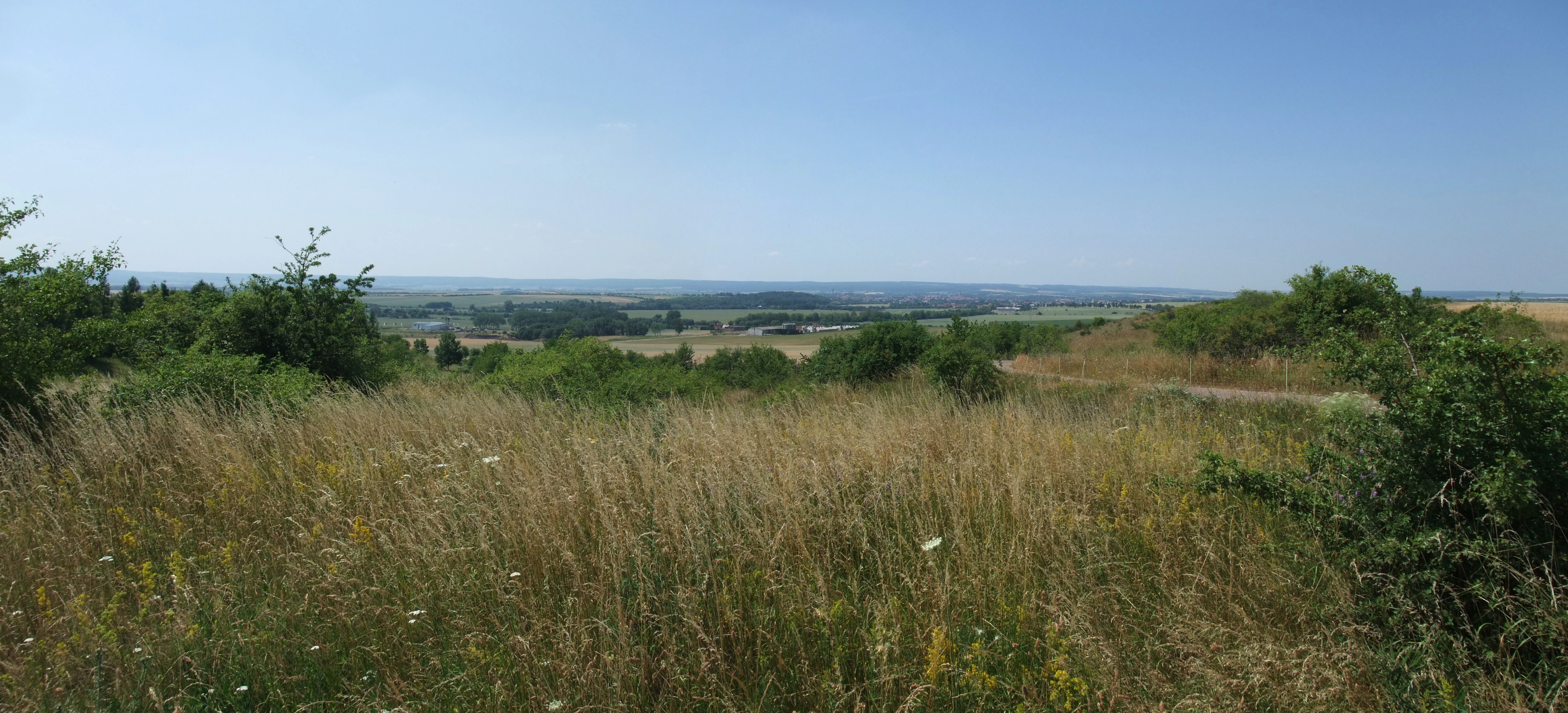
A wide, eye-level panoramic shot of a rural landscape with golden grasses and scattered shrubs in the foreground, looking out over rolling fields toward a distant, hazy horizon under a clear blue sky.
A view overlooking the hilly, rural landscape near Muehlhausen, capturing the terrain of the Grabsche Berge region.

Grabsche Berge history and protected-area timeline

The Grabsche Berge were placed under formal nature protection in 1996 as Naturschutzgebiet number 381 in the Unstrut-Hainich-Kreis. The designation recognized the long-standing botanical and conservation value of these keuper hills, which had been documented in regional botanical literature for decades.

Earlier scientific attention included an excursion by the Thuringian Botanical Society in July 1983, led by F. K. Meyer, to the steppe slopes of the Mühlhausen-Langensalza keuper basin north of the Unstrut. A later regional publication by R. Reuther and U. Fickel in the Mühlhäuser Beiträge (2006) characterized the Grabsche Berge as a valuable nature reserve at the transition between the Thuringian Basin and the Hainich heights.

Inclusion of the area within the Natura 2000 site "Keuperhügel und Unstrutniederung bei Mühlhausen" linked the reserve to a broader European framework for the conservation of its dry grassland and keuper habitats.

Grabsche Berge landscape and geographic character

The landscape of Grabsche Berge is defined by a short, clearly visible chain of low hills on the northwestern fringe of the Thuringian Basin. The hills stretch from the western Weinberg in the east, past the Kirchberg, to the Kalkkopf in the west, forming a small cuesta that descends steeply toward the Notter valley.

The terrain rises to about 248 meters on the Weinberg plateau, around 245 meters on the Kirchberg, and about 234 meters on the Kalkkopf, while the Notter valley floor lies near 190 meters above sea level. The steepest sections are found along the Kalkkopf, where the escarpment drops toward the river. The Middle Keuper substrate, with its characteristic gypsum inclusions, gives the slopes a distinct geological signature, and patches of Pleistocene terrace gravel cap parts of the plateau.

Small infrastructure elements shape the visible landscape around the reserve. The Mühlhausen airfield occupies part of the plateau southeast of the protected area, and a radio tower stands at the highest point of the reserve. The setting balances an open, dry, slope-dominated reserve core with intensive agricultural land use in the surrounding lowlands.

Grabsche Berge ecosystems, habitats, and plant life

Ecologically, Grabsche Berge represents a classic Thuringian example of a dry, warm, steppe-influenced habitat complex on keuper substrate. The combination of gypsum-bearing Middle Keuper geology, sun-exposed slopes, and thin soils creates conditions favorable for xerothermic plant communities that contrast sharply with the mesic agricultural surroundings.

The reserve is integrated into the Natura 2000 site "Keuperhügel und Unstrutniederung bei Mühlhausen", which links the keuper hills with the Unstrut floodplain. Within this broader ecological context, the Grabsche Berge contribute scattered dry grasslands, scrub-edge transitions, and elements of steppe-like vegetation that have become increasingly rare in the intensively farmed Thuringian Basin.

The area also functions as a refuge for species associated with these dry habitats, complementing the wetland and floodplain communities of the nearby Unstrut. This juxtaposition of dry hill slopes with the riverine landscape reinforces the conservation significance of the site at both local and European levels.

Grabsche Berge conservation status and protection priorities

The Grabsche Berge have been formally protected since 1996 as Naturschutzgebiet number 381, covering approximately 54 hectares in the Unstrut-Hainich-Kreis. Their principal conservation value lies in the preservation of dry grassland and steppe-like vegetation on Middle Keuper slopes, a habitat type that has been greatly reduced in the Thuringian Basin through agricultural intensification.

By being included in the Natura 2000 site "Keuperhügel und Unstrutniederung bei Mühlhausen", the reserve is linked into a continental-scale network for the protection of keuper hill habitats and adjacent floodplain ecosystems. This integration strengthens the role of Grabsche Berge as a local refugium within a coordinated regional and European conservation framework.

The site also serves as a documented botanical reference area, with excursions and publications by the Thuringian Botanical Society and regional researchers highlighting its long-term importance for monitoring xerothermic plant communities in central Germany.

Top sights and standout views in Grabsche Berge

The Grabsche Berge offer a compact example of Thuringia's keuper hill landscapes, with the steep Kalkkopf escarpment and the warm Weinberg slopes forming the reserve's most distinctive features. Their location on the edge of the Thuringian Basin, directly adjacent to the Unstrut floodplain, places them at a natural meeting point between dry hill habitats and riverine landscapes.

Although modest in size, the reserve carries weight as a Natura 2000 component and as a long-studied botanical locality, with its dry grassland and steppe-slope vegetation giving the site a clear identity despite the surrounding farmland, roads, and airfield.

Best time to visit Grabsche Berge

The dry slopes and steppe-like vegetation of Grabsche Berge are most visible in late spring and summer, when warm-loving grasses and herbs are in active growth and the contrast between the reserve and surrounding arable land is strongest. Early summer, around the period of the traditional botanical excursions, often highlights the flowering of characteristic dry-grassland species on the keuper slopes.

Vegetation on exposed slopes can be sensitive to heavy trampling, and the dry microclimate means that vegetation cover recovers slowly after disturbance, so any visit should treat the reserve as a quiet observation area rather than a place for extensive off-path walking.

Monthly climate preview

Track monthly temperature variations and precipitation averages across the protected terrain

Grabsche Berge Climate Normals, Long-Term Temperature and Precipitation Rhythm

Representative coordinate sampling reveals the long-term temperature progression and steady precipitation rates recorded across Grabsche Berge between 1991 and 2020. Examining the complete twelve-month record provides deeper clarity on annual climate normals and regional weather patterns.
Annual mean8 °C
-1 °C18 °C
Jan-1°
Feb
Mar
Apr
May12°
Jun16°
Jul18°
Aug18°
Sep14°
Oct
Nov
Dec
Warmest month
July

18.4 °C

Coolest month
January

-1.3 °C

Wettest month
July

2.6 mm/day

Driest month
April

1.4 mm/day

Park location guide

Geography guide, regional context, and park location map for Grabsche Berge

Grabsche Berge park geography, regions, and map view in Germany

Understand where Grabsche Berge sits in Germany through a broader geographic reading of the surrounding landscape, nearby location context, and its mapped position within the national park landscape.

How Grabsche Berge fits into Germany

Germany is a federal republic in Western and Central Europe with a population of over 83 million across sixteen constituent states. It is Europe's largest economy by nominal GDP and a major global exporter and importer. The capital is Berlin, and the country borders Denmark, Poland, Czech Republic, Austria, Switzerland, France, Luxembourg, Belgium, and the Netherlands.

Wider geography shaping Grabsche Berge in Germany

Germany is located in Western and Central Europe, spanning 357,022 km². It borders Denmark to the north, Poland and the Czech Republic to the east, Austria and Switzerland to the south, and France, Luxembourg, Belgium, and the Netherlands to the west. The country has coastlines on the Baltic Sea and North Sea to the north, with the Alps located in the southern region.

Map view of Grabsche Berge

Use this park location map to pinpoint Grabsche Berge in Germany, understand its exact geographic position, and read its mapped placement within the surrounding landscape more clearly.

Pigeon | © OpenStreetMap contributors

Location context for Grabsche Berge

ThuringiaUnstrut-Hainich-Kreis

Explore protected area views, dry slopes, and the distinct terrain of Thuringia

Grabsche Berge Photos and Landscape Scenery: Visualizing Keuper Hills

Visual documentation captures the steep keuper slopes, dry grassland habitats, and distinctive cuesta topography that define the protected landscape. Examining field photography reveals the ecological character of the hill chain rising above the agricultural lowlands.

A wide, eye-level panoramic shot of a rural landscape with golden grasses and scattered shrubs in the foreground, looking out over rolling fields toward a distant, hazy horizon under a clear blue sky.

Park atlas

Compare regional keuper hills and connected protected landscapes

Explore Protected Areas and Parks Near Grabsche Berge in Thuringia

Browse other parks near Grabsche Berge to examine similar dry grassland habitats and keuper hill topography across the Thuringian Basin. Expanding the regional view helps place local protected areas into a broader geographical comparison of terrain and vegetation.
Watercolor painting of a green, rolling valley with muted pastel tones.
Nature reserveThuringia
About 5.6 km away#1 closest

Northwest

Flachstal Nature Reserve: Geographic Profile and Protected Valley Landscapes in Thuringia

Ecologically rich calcareous dry valley and protected habitat mosaic

Flachstal represents a significant nature reserve within Thuringia, defined by its steep flanks of Muschelkalk limestone and centuries of traditional sheep grazing. This dry valley functions as both a hotspot for grassland species and a vital climate corridor for the surrounding plateau. The site offers an opportunity to study the intersection of geological history, fossil-rich streambeds, and modern conservation management within the Natura 2000 network.

Area
1.876 km²
Established
1999
IUCN
IV
Relief
Upland
Watercolor illustration of a landscape featuring green fields, trees, a river, and distant hills under a pale sky
National parkThuringia
About 12 km away#2 closest

Southwest

Hainich National Park: Protected Ancient Beech Forest Landscape in Thuringia, Germany

Regional geography and primeval forest boundaries

Hainich National Park occupies 75 square kilometers of the larger Hainich forest in western Thuringia. This canonical protected area is defined by its ancient beech woodland and ongoing forest restoration processes. The geography of the region, situated between Eisenach and Bad Langensalza, provides a critical example of primary forest dynamics and central European biodiversity, serving as an anchor for environmental research and landscape analysis.

Area
75 km²
Established
1997
IUCN
II
Climate
Temperate
A watercolor painting of a rolling, forested landscape with soft green and pink tones, featuring gentle hills and vegetation.
National parkThuringia
About 12 km away#3 closest

Southwest

Nationalpark Hainich: Exploring the Geography of Thuringia's Beech Forest Wilderness

Mapped protected landscapes in the German heartland

Nationalpark Hainich protects one of the most important remaining deciduous woodlands in Central Europe. This detailed atlas entry covers the park's rolling terrain, the transition of its former training grounds into wild forest, and the geographic context of its position within the broader Thuringian landscape.

Area
75 km²
Established
1997
Relief
Upland
Climate
Temperate
A soft watercolor painting of a meadow landscape, featuring a dirt path winding through wildflowers toward green trees with rolling hills in the background.
Nature reserveThuringia
About 13 km away#4 closest

Northwest

Kühmstedter Berg Nature Reserve: A Protected Landscape and Archaeological Site in Thuringia

Examining forest ecology and medieval earthworks on a central German ridge

Kühmstedter Berg stands as a protected nature reserve in Thuringia, characterized by its Muschelkalk geology and established beech-rich oak and hornbeam woodland. This site maps a critical intersection of natural forest habitat and historical land use, featuring visible remnants of a Bronze Age tumulus cemetery and the defensive lines of the medieval Mühlhäuser Landgraben.

Area
0.387 km²
Established
1961
Relief
Upland
Scope
Terrestrial
A horizontal watercolor painting showing rolling green and yellow hills with distant purple-toned forests against a white background.
Nature reserveThuringia
About 16 km away#5 closest

North

Keulaer Wald Nature Reserve: Geographic Overview of the Dün Plateau Forest in Thuringia

Mapped beech-dominated plenterwald and limestone escarpment terrain

Located in northern Thuringia, Keulaer Wald is a designated nature reserve characterized by its continuous beech canopy on shell limestone bedrock. This site serves as a vital protected area within the regional forest belt, offering high-elevation viewpoints over the surrounding Eichsfeld Basin and the distant Harz mountain range.

Area
2.97 km²
Established
1961
Relief
Mountain
Climate
Temperate
Nature reserveThuringia
About 16 km away#6 closest

East

Großer Horn Nature Reserve: Protected Forest Geography and Mapped Landscape Context

A vital woodland reference site in the Thuringian Basin.

Großer Horn is a long-standing nature reserve located in northern Thuringia, notable for its strict totalreservat core and diverse forest composition. The protected area features an intricate soil mosaic of loess loam and limestone, supporting distinct oak and beech forest communities. This isolated habitat island provides essential insight into the ecological character of the subcontinental forest transition zone.

Area
0.159 km²
Established
1961
Relief
Upland
Climate
Temperate
Nature reserveThuringia
About 19 km away#7 closest

West

Werrahänge von Frankenroda bis Falken: A Deep Dive into Thuringian Protected Landscapes

Mapping limestone river canyons and unique forest habitats in Wartburgkreis.

This protected area captures a distinct geomorphological intersection of river-cut canyons and plateau ridges in Thuringia. The site preserves an intense mosaic of juniper heath, dry grasslands, and ancient beech forests, functioning as a vital link for species conservation. Examine the mapped boundaries, karst features, and the sculptural topography formed by the Werra river as it winds through the Muschelkalk rim of the Thuringian Basin.

Area
5.69 km²
Established
1999
IUCN
IV
Relief
Upland
A wide watercolor painting showing a gentle river winding through green hills with pink flowering trees and pale blue mountains in the background.
Nature reserveUnstrut-Hainich-Kreis
About 19 km away#8 closest

West

Klosterschranne, Faulunger Stein Nature Reserve: Mapped Boundaries and Regional Geography

A protected Muschelkalk valley landscape in the Thuringia region

Klosterschranne, Faulunger Stein consists of a protected woodland and rock environment shaped by limestone erosion. The reserve features sharp valley spurs, calcareous springs, and cliffs that rise up to thirty meters, anchoring a larger network of habitats within the Upper Eichsfeld plateau. Users can examine the layered conservation status and distinct topographic features that define this ecologically significant German site.

Area
2.983 km²
Established
1996
IUCN
IV
Relief
Mountain

Common questions about visiting, size, designation, and location context for Grabsche Berge

Grabsche Berge FAQs for park facts, access, geography, and protected area context

Find quick answers about Grabsche Berge, including protected-area facts, park geography, trail and visitor context, and how the park fits into its surrounding country and regional landscape.
MoriAtlas Explorer

Continue Your Protected Areas Search Across the Global Atlas

Deepen your exploration by continuing the structured search for national parks and protected areas worldwide. Utilize the comprehensive filtering capabilities to compare different conservation landscapes and refine your understanding of global park geography. Discover more about the distribution and characteristics of protected natural areas.

Global natural geography