

Mori Atlas logo
State or regional parkGraham-Laurier Provincial Park

A vast protected landscape defining the character of the northern Peace River region

Graham-Laurier Provincial Park: Mapping the Remote Boreal Wilderness of British Columbia

Graham-Laurier Provincial Park stands as a sprawling protected area within northeastern British Columbia, encompassing approximately 100,000 hectares of rugged northern boreal terrain. As a vital component of the Muskwa-Kechika Management Area, the landscape features intricate river corridors, forested ridges, and the prominent Christina Falls. This atlas entry provides essential geographic context and boundary information for those navigating this remote, undeveloped region of Canadian wilderness.

boreal forestremote wildernessMuskwa-KechikaBritish ColumbiaPeace River regionChristina Falls

Graham-Laurier Provincial Park

State or regional park

Park overview

Structured park overview, official facts, and landscape profile for Graham-Laurier Provincial Park

Graham-Laurier Provincial Park park facts, protected area profile, and essential visitor context

Review the core facts for Graham-Laurier Provincial Park, including designation, size, terrain, visitor scale, habitats, and operating context in one park-focused overview.

About Graham-Laurier Provincial Park

Graham-Laurier Provincial Park is a substantial wilderness reserve in the far north of British Columbia, occupying a place in a region where conservation and resource use intersect. With an area approaching 100,000 hectares, it represents one of the larger provincial park units in the Peace River region and contributes meaningfully to the connective habitat network of the surrounding Muskwa-Kechika Management Area.

The surrounding landscape is characteristic of northeastern British Columbia: boreal forest, rolling uplands, river valleys, and rugged terrain that transitions between lowland and higher-elevation environments. This northern setting gives the park a distinct ecological identity, shaped by long winters, short growing seasons, and wildlife communities adapted to subarctic-influenced conditions.

The park is managed with an emphasis on retaining its wilderness character. Access is deliberately limited: a single forest service road serves as the primary motorized route, while the broader trail system supports ATVs, hiking, and other non-motorized recreation. This approach balances recreational use with the preservation of a largely undeveloped landscape, allowing the park to function as both a wildlife refuge and a destination for self-reliant backcountry visitors.

For travelers, Graham-Laurier offers an experience defined by remoteness and self-sufficiency rather than by amenities. The journey to the park, often beginning from Fort St. John and continuing along remote forest service roads, is itself part of the experience. Once inside the boundary, visitors encounter a working northern wilderness where quiet trails, broad vistas, and the seasonal rhythms of boreal weather shape the visit.

Quick facts and research context for Graham-Laurier Provincial Park

Graham-Laurier Provincial Park is located in the Peace River Regional District of northeastern British Columbia, approximately 145 km northwest of Fort St. John. Established on June 29, 1999, the park covers about 99,982 hectares and is managed by BC Parks. It is classified as an IUCN Category II protected area, equivalent to a national park in its level of protection.

The park lies within the Muskwa-Kechika Management Area, a vast region of largely undeveloped boreal forest and mountain terrain. Its access infrastructure is minimal, with the Halfway/Graham Forest Service Road providing the main motorized entry point and a system of trails, including the Christina Falls trail, supporting foot and ATV travel within the park boundary.

Protection and recognition

Examine the terrestrial protection status and governance framework for Graham-Laurier Provincial Park.

Graham-Laurier Provincial Park Protection Status and Conservation Scope

Terrestrial protection status and administrative management records establish the conservation scope for Graham-Laurier Provincial Park. Detailed protection facts and official designation data provide clarity on the legal boundaries governing this protected area.

Protection details

Protection scope
Terrestrial
Transboundary protection
No
Park context

Deeper park guide and search-rich context for Graham-Laurier Provincial Park

Graham-Laurier Provincial Park history, landscape, wildlife, and travel context

Explore Graham-Laurier Provincial Park through its history, landscape character, ecosystems, wildlife, conservation priorities, cultural context, and seasonal travel timing in a structured park guide built for atlas discovery and search intent.

Why Graham-Laurier Provincial Park stands out

Graham-Laurier Provincial Park is best known for its position within the Muskwa-Kechika Management Area, one of the most expansive intact wilderness areas remaining in North America. Its remote boreal setting, large uninterrupted size, and limited development distinguish it from more accessible parks in southern British Columbia. The park is also known for Christina Falls and the rugged trail-based access that defines the visitor experience. Hunting, backcountry travel, and exploration of an otherwise untouched northern landscape are the core draws, making Graham-Laurier a destination for those seeking solitude rather than developed facilities.

Graham-Laurier Provincial Park history and protected-area timeline

Graham-Laurier Provincial Park was formally established on June 29, 1999, as part of British Columbia's ongoing effort to expand its network of protected wilderness areas in the north. Its creation reflected a broader provincial interest in conserving representative portions of the boreal landscape and ensuring that ecological values were maintained alongside the resource industries that dominate the Peace River region.

The park's location within the Muskwa-Kechika Management Area is central to its history. The Muskwa-Kechika initiative, launched in the late 1990s, sought to balance conservation with resource development across an enormous region of northern British Columbia, and Graham-Laurier was established as one of the contributing protected-area anchors within that framework. Its management has since been overseen by BC Parks, which maintains the park's wilderness-focused character and limits infrastructure development to preserve the area's natural condition.

Graham-Laurier Provincial Park landscape and geographic character

Graham-Laurier Provincial Park occupies a varied northern landscape typical of the Peace River region of British Columbia. The terrain includes boreal forest uplands, valley systems, and transition zones that give the park a layered topographic character. The remoteness and limited development of the area mean that the landscape remains largely in its natural state, with vegetation, hydrology, and landforms shaped primarily by natural processes.

The park's most visually distinctive feature is Christina Falls, located along one of the park's principal trails. Surrounding terrain includes river and creek corridors, forested ridges, and rolling country that connects the park to the broader Muskwa-Kechika region. This setting produces a wilderness landscape defined by openness, scale, and the subtle transitions that characterize northern boreal environments, where forest, water, and elevation shifts combine into extended vistas rather than dramatic single focal points.

Graham-Laurier Provincial Park ecosystems, habitats, and plant life

The park's natural environment is defined by its boreal character, with vegetation patterns shaped by northern latitude, elevation variation, and a relatively undisturbed ecological setting. Forests, wetlands, and upland communities together form the ecological baseline of the park, supporting a connected landscape that extends outward into the surrounding Muskwa-Kechika region.

Because Graham-Laurier lies within such a large and intact management area, its ecological value is closely linked to the broader wilderness framework around it. The park functions as part of a continuous habitat matrix rather than an isolated reserve, allowing ecological processes such as wildlife movement, seasonal migration, and natural disturbance cycles to operate across a wide landscape. This connectedness gives the park a more meaningful ecological role than its individual boundaries alone would suggest.

Graham-Laurier Provincial Park wildlife and species highlights

Graham-Laurier's remote setting and connection to the wider Muskwa-Kechika region support the wildlife values for which the park is best known. The area is recognized as habitat for northern boreal species, including large mammals that depend on extensive undeveloped terrain. Hunting, noted as the park's main recreational activity, reflects the presence of species that have long drawn both subsistence and sport hunters to the region.

The park's function as part of a much larger wilderness landscape enhances its value for wildlife, providing room for seasonal movements and reducing the fragmentation that affects more developed parts of the province. This makes Graham-Laurier less a destination for casual wildlife viewing and more an anchor of intact habitat within a regionally significant ecosystem.

Graham-Laurier Provincial Park conservation status and protection priorities

The conservation significance of Graham-Laurier Provincial Park is tied closely to its placement within the Muskwa-Kechika Management Area, one of the most ambitious landscape-scale conservation frameworks in North America. By occupying a large block of protected land within this system, the park contributes to the maintenance of ecological connectivity across a vast region of northeastern British Columbia.

Its IUCN Category II designation reflects a high level of protection aimed at preserving natural ecosystems and ecological processes. Limited infrastructure, restricted motorized access, and a management approach that prioritizes wilderness character all reinforce the park's conservation intent. The result is a protected area that complements the resource-use activities around it by securing a representative portion of the region's natural heritage in an undeveloped state.

Graham-Laurier Provincial Park cultural meaning and human context

The cultural context of Graham-Laurier Provincial Park is shaped primarily by its place within a northern landscape that has long been the setting for hunting, trapping, and resource-oriented land use. The Peace River region carries a heritage of Indigenous presence and of more recent settlement patterns tied to forestry, energy, and frontier recreation, and the park sits within this broader regional identity.

The park's emphasis on hunting as a recreational activity reflects the cultural relationship that residents and visitors have with the surrounding landscape. While Graham-Laurier itself does not contain developed interpretive or heritage facilities, its setting within a culturally rich northern region gives visitors a sense of a landscape where human history, resource use, and wilderness values continue to coexist.

Top sights and standout views in Graham-Laurier Provincial Park

Graham-Laurier Provincial Park's primary highlight is its status as part of the Muskwa-Kechika Management Area, anchoring one of the largest intact wilderness landscapes in North America. Its scale, isolation, and undeveloped condition give it a value that goes beyond single landmarks, making the park itself a defining feature of the regional landscape.

Secondary highlights include Christina Falls and the network of trails that allow visitors to experience the park on foot or by ATV. The Halfway/Graham Forest Service Road provides the main entry point, reinforcing the park's identity as a destination for self-reliant travelers comfortable with the demands of northern backcountry travel.

Best time to visit Graham-Laurier Provincial Park

The park's northern boreal setting means visitor experience is shaped strongly by season. Summer and early autumn are the most reliable windows for travel, when forest service roads and trails are accessible and weather conditions support backcountry activity. Winter brings heavy snow and extreme cold, limiting access and transforming the park into a much more specialized destination. Visitors generally time trips around the warmer months to take advantage of trail conditions, longer daylight hours, and the reduced logistical challenge of reaching such a remote location.
Monthly climate preview

Long-term temperature and precipitation averages for British Columbia protected terrain

Graham-Laurier Provincial Park Climate Normals and Monthly Weather Records

Representative coordinate records show measured monthly temperature and precipitation rhythms across Graham-Laurier Provincial Park from 1991 to 2020. Examining the complete twelve-month climate profile provides detailed insight into long-term environmental patterns at a reference elevation of 1345.55 meters.
Annual mean-3 °C
-15 °C11 °C
Jan-15°
Feb-14°
Mar-10°
Apr-4°
May
Jun
Jul11°
Aug10°
Sep
Oct-2°
Nov-11°
Dec-15°
Warmest month
July

11 °C

Coolest month
January

-15.3 °C

Wettest month
June

3.7 mm/day

Driest month
February

1.5 mm/day

Park location guide

Geography guide, regional context, and park location map for Graham-Laurier Provincial Park

Graham-Laurier Provincial Park park geography, regions, and map view in Canada

Understand where Graham-Laurier Provincial Park sits in Canada through a broader geographic reading of the surrounding landscape, nearby location context, and its mapped position within the national park landscape.

How Graham-Laurier Provincial Park fits into Canada

Canada is a federal parliamentary constitutional monarchy spanning North America from the Atlantic to the Pacific and Arctic Oceans. With a population of over 41 million, it is officially bilingual in English and French at the federal level. The country gained independence from the United Kingdom through a gradual process culminating in 1982.

Wider geography shaping Graham-Laurier Provincial Park in Canada

Canada occupies the northern portion of North America, sharing its longest international border with the United States. The country extends from the Atlantic Ocean to the Pacific Ocean and northward into the Arctic Ocean, giving it the longest coastline of any nation.

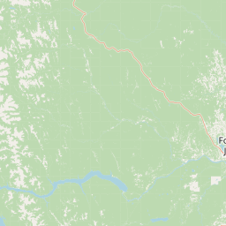
Map view of Graham-Laurier Provincial Park

Use this park location map to pinpoint Graham-Laurier Provincial Park in Canada, understand its exact geographic position, and read its mapped placement within the surrounding landscape more clearly.

Pigeon | © OpenStreetMap contributors

Location context for Graham-Laurier Provincial Park

British Columbia
Natural feature types

Explore the Geographic Landmarks of Graham-Laurier Provincial Park

Navigate the complete collection of named natural features associated with Graham-Laurier Provincial Park. Use this structured data from MoriAtlas to understand the boreal terrain, waterways, and diverse landforms that characterize this remote British Columbia wilderness.
Recorded earthquake history

Explore Historical Earthquake Records for Graham-Laurier Provincial Park

Review the recorded seismic history associated with the landscape of Graham-Laurier Provincial Park. This catalogue compiles verified event data, including magnitude and distance metrics, to help researchers and enthusiasts better understand regional geological patterns throughout the British Columbia wilderness.

Graham-Laurier Provincial Park Earthquake History

Catalogued events

2 events

Strongest magnitude

Magnitude 4

Most recent event

Sep 29, 2010

This history includes earthquakes recorded inside the park or within 50 km of its borders

Park atlas

Compare adjacent protected areas and connected northern boreal landscapes

Explore Parks Near Graham-Laurier Provincial Park and Surrounding Wilderness

Compare Graham-Laurier Provincial Park with other remote wilderness reserves across the surrounding region. Broaden your geographic perspective by examining neighboring boreal terrain and protected landscapes.
State or regional parkBritish Columbia
43 km away#1 closest

North

Redfern-Keily Provincial Park: A Deep Dive into Muskwa Ranges Protected Geography

Remote Glacial Landscapes and Northern Wilderness Terrain

Redfern-Keily Provincial Park encompasses a significant stretch of remote wilderness in the Muskwa Ranges of northeastern British Columbia. Anchored by the eight-kilometer Redfern Lake and surrounding glaciers like the Ithaca and Achaean, the area serves as a primary example of intact boreal and subalpine geography. The terrain offers a rugged look at high-elevation ecosystems and glacial history within the Muskwa-Kechika Management Area.

Area
807.12 km²
Established
1999
IUCN
II
Relief
Mountain
State or regional parkBritish Columbia
About 46 km away#2 closest

Northeast

Pink Mountain Provincial Park: Regional Geography and Protected Alpine Landscapes

Muskwa Foothills terrain and scientific conservation history.

Situated in the eastern foothills of the Rocky Mountains, Pink Mountain Provincial Park is defined by its transition from forested valleys to high-altitude tundra. This protected area stands as a unique ecological corridor, preserving major Mesozoic fossil sites and providing a habitat for diverse northern wildlife species that thrive in the cold-adapted vegetation of the Muskwa Foothills.

Area
0.98 km²
Established
1999
IUCN
II
Relief
Mountain
State or regional parkBritish Columbia
About 93 km away#3 closest

North

Prophet River Hot Springs Provincial Park: Protected Landscape and Geothermal Geography

Remote backcountry wilderness in northeastern British Columbia

Prophet River Hot Springs Provincial Park is a specialized protected area known for its unique tufa mounds and geothermal features. Set against the mountainous backdrop of the Muskwa Ranges, this backcountry destination offers a compelling study of boreal and subalpine geography, accessible only by hiking or horseback through undisturbed wilderness corridors.

Area
1.84 km²
Established
1999
IUCN
II
Relief
Mountain
State or regional parkBritish Columbia
110 km away#4 closest

Northwest

Kwadacha Wilderness Provincial Park: Geographic Boundaries and Regional Protected Area Context

Untouched mountain wilderness in northern British Columbia

Kwadacha Wilderness Provincial Park provides a rare, roadless mountain experience within the northeastern interior of British Columbia. Characterized by high-relief alpine ridges, dense boreal forests, and challenging river systems, the park represents an essential wilderness corridor that remains free from human infrastructure and standard road access, prioritizing ecological integrity over recreation.

Area
1,302.79 km²
Established
1973
IUCN
Ib
Relief
Mountain
Watercolor painting of a long truss bridge spanning a river winding through a valley with hills and trees in the background.
State or regional parkBritish Columbia
About 155 km away#5 closest

East

Kiskatinaw Provincial Park: A Protected Landscape Along the Historic Alaska Highway

Geography and heritage in the Peace River region of British Columbia

Kiskatinaw Provincial Park encompasses a distinctive horseshoe meander of the Kiskatinaw River, creating a deep gorge carved into the terrain of northeastern British Columbia. This protected area serves as a focal point for understanding both the river geomorphology of the Peace River Country and the engineering history of the original Alaska Highway, exemplified by the iconic 1942 wooden trestle bridge.

Area
0.58 km²
Established
1962
IUCN
II
Relief
Upland
State or regional parkBritish Columbia
About 167 km away#6 closest

Northwest

Finlay-Russel Provincial Park and Protected Area: Mapping Northern British Columbia Wilderness

A remote river corridor in the Muskwa-Kechika Management Area.

Located in northern British Columbia, Finlay-Russel Provincial Park and Protected Area preserves an essential 85-kilometre river corridor along the Finlay River. This expansive wilderness territory serves as an integral part of the Muskwa-Kechika Management Area, showcasing deep boreal forest landscapes and rugged river valley terrain far from established road networks.

Area
1,092.05 km²
Established
2001
IUCN
II
Access
Remote access
State or regional parkBritish Columbia
About 231 km away#7 closest

Northwest

Dune Za Keyih Provincial Park and Protected Area: Watershed and Terrain Geography

Remote wilderness landscape in northern British Columbia

Dune Za Keyih Provincial Park and Protected Area protects the largest unlogged watershed in British Columbia. Situated within the Muskwa-Kechika Management Area, this remote wilderness is defined by the geological structures of the Rocky Mountain Trench, providing a continuous corridor of undisturbed mountain forest, riparian zones, and highland terrain.

Area
3,468.33 km²
Established
2001
IUCN
Ib
Relief
Mountain
State or regional parkBritish Columbia
About 266 km away#8 closest

North

Jackpine Remnant Provincial Park: Protected Boreal Landscape and Regional Map Context

Conservation and terrain data for the Fort Nelson region

Jackpine Remnant Provincial Park provides a critical study in northern conservation geography. Located in the Fort Nelson area of British Columbia, this 148-hectare site protects a rare stand of jack pine trees. Its mapped boundaries and boreal forest terrain offer a focused look at small-scale protected landscapes and their significance within the broader regional ecosystem of the Canadian north.

Area
1.48 km²
Established
2001
IUCN
II
Relief
Lowland

Common questions about visiting, size, designation, and location context for Graham-Laurier Provincial Park

Graham-Laurier Provincial Park FAQs for park facts, access, geography, and protected area context

Find quick answers about Graham-Laurier Provincial Park, including protected-area facts, park geography, trail and visitor context, and how the park fits into its surrounding country and regional landscape.
MoriAtlas Explorer

Continue Your Protected Areas Search Across the Global Atlas

Deepen your exploration by continuing the structured search for national parks and protected areas worldwide. Utilize the comprehensive filtering capabilities to compare different conservation landscapes and refine your understanding of global park geography. Discover more about the distribution and characteristics of protected natural areas.

Global natural geography