

Mori Atlas logo
Protected landscapeGrand River National Grassland

Examining the intersection of riparian corridors, badlands, and restored prairie ecosystems.

Grand River National Grassland: A Comprehensive Map of Protected Northern Great Plains Landscapes

Grand River National Grassland encompasses a vast mosaic of protected territory in northwestern South Dakota. This atlas entry details the convergence of the Grand River forks, sandstone outcrops, and diverse sand dune formations that define the region. By analyzing the intersection of tribal lands and federal conservation zones, the records highlight a distinct geographic evolution from homesteaded cropland to rehabilitated prairie wilderness.

national grasslandmixed grass prairiebadlandsgreat plainsriparian woodlandsand dunes

Grand River National Grassland

Protected landscape

Park overview

Structured park overview, official facts, and landscape profile for Grand River National Grassland

Grand River National Grassland park facts, protected area profile, and essential visitor context

Review the core facts for Grand River National Grassland, including designation, size, terrain, visitor scale, habitats, and operating context in one park-focused overview.

About Grand River National Grassland

Grand River National Grassland is a National Grassland located in the northwestern reaches of South Dakota, in the heart of the northern Great Plains. The protected landscape covers 154,783 acres and is administered by the U.S. Forest Service within the larger Dakota Prairie Grasslands, a regional unit that links several grassland units across the Dakotas. A local ranger district office, shared with the neighboring Cedar River National Grassland, is located in Lemmon, South Dakota.

At its core, the grassland protects a striking variety of Great Plains habitats that are not typically found together. Mixed grass prairie forms the ecological backbone, while the riparian corridor along the North and South forks of the Grand River introduces green ash draws, river-bottom woodlands, and cottonwood plantings that stand out from the surrounding arid plains. Scenic contrast is supplied by badlands, sandstone buttes and outcrops, active sand dunes along the South Fork of the Grand River, and claypan flats dotted with small playas in Corson County.

Beyond its natural character, the grassland reflects one of the most consequential land-recovery stories in the American West. In the early 1900s, the area was opened to homesteading, and settlers attempted to farm land that proved marginal under repeated drought. The Dust Bowl conditions of the 1930s forced the federal government to step in, and the resulting program of land purchase, consolidation, and rehabilitation eventually led to the 1960 designation of Grand River National Grassland. Its territory also overlaps with portions of the Standing Rock Sioux and Cheyenne River Indian reservations, a heritage that continues to shape how the landscape is understood and managed today.

Quick facts and research context for Grand River National Grassland

Grand River National Grassland occupies roughly 154,783 acres across parts of Perkins, Corson, and Ziebach counties in northwestern South Dakota. It is administered by the USDA Forest Service as part of the Dakota Prairie Grasslands, with a local ranger district office in Lemmon shared with Cedar River National Grassland. The protected area overlays portions of the Standing Rock Sioux Reservation and the Cheyenne River Indian Reservation, giving it both natural resource and cultural significance. Established as a National Grassland in 1960, it represents one of the products of the federal response to the Great Depression-era Dust Bowl crisis.

Protection and recognition

Documented terrestrial protection scope and historical designation data

Grand River National Grassland Protection Status and Designation History

Grand River National Grassland maintains a documented terrestrial protection scope established in 1960. Official records compile the designation history and management framework without imported international recognition sources.

Protection details

Protection scope
Terrestrial
Designated year
1960
Transboundary protection
No
Park context

Deeper park guide and search-rich context for Grand River National Grassland

Grand River National Grassland history, landscape, wildlife, and travel context

Explore Grand River National Grassland through its history, landscape character, ecosystems, wildlife, conservation priorities, cultural context, and seasonal travel timing in a structured park guide built for atlas discovery and search intent.

Why Grand River National Grassland stands out

Grand River National Grassland is best known for its restored mixed grass prairie and badlands scenery, which trace their origins to one of the most dramatic conservation responses in the northern Great Plains. It combines native northern Great Plains habitats with old stands of reseeded crested wheatgrass and remnant cropland, creating a distinctive patchwork of grassland types. The grassland is also recognized for the convergence of the North and South forks of the Grand River within its boundaries, sand dune formations along the South Fork, isolated aspen stands set against typical prairie habitat, and for sharing shoreline with Shadehill Reservoir. Its overlapping presence on two Sioux reservations adds a strong cultural dimension to its natural resource profile.
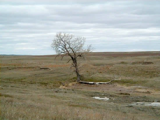
A wide, eye-level shot of a single bare tree standing in a vast, open grassland under a cloudy sky.
A lone, leafless tree stands in the expansive, grassy terrain of the Grand River National Grassland.

Grand River National Grassland history and protected-area timeline

Grand River National Grassland has its origins in the early homesteading era of the twentieth century, when the federal Homestead Act encouraged settlers to break the native prairie of northwestern South Dakota for cropland. The semi-arid character of the land was poorly suited to cultivation, and when a severe drought struck in the 1930s, the region was devastated by wind erosion and the collapse of farming communities during the Great Depression.

In response, the federal government purchased failed homesteads under the Agricultural Adjustment Act, consolidating them and beginning a long process of land rehabilitation. These efforts included reseeding old cropland to crested wheatgrass, planting cottonwoods along the South Fork of the Grand River, and more recent work to reintroduce native seed mixes. In 1960, the consolidated lands were formally designated Grand River National Grassland and placed under the administration of the U.S. Forest Service.

The grassland became part of what is now known as the Dakota Prairie Grasslands, which groups several grassland units under a single administrative framework. The long-term result is a landscape that combines restored native habitat, planted grassland stands, and a network of rangeland uses that continues to support both wildlife and the ranching economy of the region.

Grand River National Grassland landscape and geographic character

Grand River National Grassland occupies a varied piece of the northern Great Plains where the terrain shifts between flat prairie and broken, sculpted country. The mixed grass prairie is the dominant landform, but it is interrupted by a series of more dramatic features that give the area unexpected scenic variety.

Badlands and sandstone outcrops introduce eroded ridges, buttes, and rugged slopes that contrast sharply with the gently rolling grasslands surrounding them. Along the South Fork of the Grand River, active sand dunes create soft, rolling deposits, while claypan flats in Corson County hold seasonal water in small playas. The riparian corridor along the North and South forks provides a narrow but ecologically important thread of river-bottom habitat and green ash draws, supplemented by cottonwood plantings aimed at stabilizing streambanks and improving shelter for wildlife.

Grand River National Grassland ecosystems, habitats, and plant life

Ecologically, Grand River National Grassland represents a transition zone where several Great Plains habitats meet. The dominant mixed grass prairie supports a wide range of plant and animal life adapted to semi-arid conditions, including both cool-season and warm-season grass species characteristic of the northern Great Plains. Roughly 20,000 acres of the unit consist of old cropland reseeded to crested wheatgrass, which forms large uniform stands that contrast with the more diverse native prairie remnants.

Wetland and riparian systems add another layer of ecological richness. The North and South forks of the Grand River and their associated draws support green ash and cottonwood, while claypan depressions and small playas in Corson County provide seasonal wetland habitat that is increasingly rare across the region. Sand dune margins, badlands slopes, and sandstone outcrops each host their own specialized plant communities, and small aspen stands near the Blacktail Trail add an unusual forested element to an otherwise open landscape. A comprehensive birding checklist and ongoing biological surveys document the diversity of species using these varied habitats.

Grand River National Grassland wildlife and species highlights

Wildlife on Grand River National Grassland reflects the diversity of habitats available across the unit. The mixed grass prairie and crested wheatgrass stands support grassland songbirds, small mammals, and large grazing animals, while the river-bottom corridors and draws provide shelter for species that depend on woody cover and water.

Seasonal playa wetlands in Corson County, the shoreline of Shadehill Reservoir, and the riparian plantings along the South Fork together create important stopover and nesting habitat for migrating and breeding birds. The grassland's size and habitat variety make it a recognized destination for birding, and the Forest Service maintains a comprehensive checklist of bird species recorded on the district. Larger mammal species typical of the northern Great Plains are also present, and visitors commonly share the landscape with livestock that continue to graze the open range.

Grand River National Grassland conservation status and protection priorities

Grand River National Grassland is significant from a conservation standpoint both as a recovered landscape and as a refuge for diverse northern Great Plains ecosystems. Its very existence reflects a major federal program to reverse the wind erosion and farm collapse that defined the Dust Bowl era in the northwestern plains.

Ongoing management focuses on balancing rangeland use, habitat restoration, and ecological recovery. Reintroducing native grass mixes into old crested wheatgrass stands, planting cottonwoods along the South Fork, and protecting mixed grass prairie from further cultivation all reflect long-term efforts to rebuild the area's ecological integrity. The grassland also serves as a reserve of habitat for grassland birds and other species of conservation concern, and its overlap with two Sioux reservations underscores the importance of considering tribal land and cultural values alongside ecological management.

Grand River National Grassland cultural meaning and human context

Grand River National Grassland sits within a landscape of deep and ongoing cultural significance. The portion of the grassland in Corson County lies within the Standing Rock Sioux Reservation, and the portion in Ziebach County lies within the Cheyenne River Indian Reservation, tying the protected area directly to tribal lands and communities with longstanding ties to this part of the Great Plains.

The area also carries the visible marks of early twentieth-century homesteading and the Dust Bowl era. Failed homesteads, abandoned cropland, and patterns of land ownership shaped by Depression-era federal programs form an important part of the region's human story. These layers of homesteading history and continuing tribal presence together give the grassland a cultural depth that extends well beyond its ecological function.

Top sights and standout views in Grand River National Grassland

Grand River National Grassland stands out for combining restored Dust Bowl-era cropland with a rich mix of native prairie, badlands, sand dunes, and riparian woodland along the North and South forks of the Grand River. Its overlap with the Standing Rock Sioux Reservation and the Cheyenne River Indian Reservation adds a distinctive cultural layer to a primarily ecological landscape, while the Blacktail Trail and Shadehill Reservoir shoreline create anchored points for hiking, horseback riding, mountain biking, fishing, and birding.

The presence of rare aspen stands amid the prairie, active sand dune systems along the South Fork, and small playa wetlands in Corson County give the unit a habitat diversity rarely matched within a single National Grassland. Together with its scale and its proximity to other grasslands under the Dakota Prairie Grasslands umbrella, Grand River offers a broad, varied experience of the northern Great Plains.

Best time to visit Grand River National Grassland

The character of Grand River National Grassland shifts with the seasons in ways typical of the northern Great Plains. Spring and early summer bring greener grass cover, blooming wildflowers in the mixed grass prairie, and heightened bird activity, which is particularly rewarding for visitors interested in birding and the playa wetlands in Corson County.

Late summer and early fall tend to be warmer and drier, with more golden prairie tones and active wildlife behavior around water sources, including Shadehill Reservoir. Winter visits offer a quieter, more open feel to the landscape, though travelers should be prepared for cold northern plains conditions. Because the grassland is open to grazing livestock on a year-round basis, visitors at any season should expect to share the range with cattle.
Monthly climate preview

Track long-term monthly temperature and precipitation rhythms across the protected landscape

Grand River National Grassland Climate Normals and Annual Temperature Patterns

Representative coordinate measurements reveal a wide annual temperature range alongside distinct monthly precipitation variations across the protected terrain. Analyzing the full twelve-month dataset clarifies long-term climate normals and persistent weather patterns for Grand River National Grassland.
Annual mean8 °C
-6 °C24 °C
Jan-6°
Feb-4°
Mar
Apr
May14°
Jun20°
Jul24°
Aug22°
Sep16°
Oct
Nov
Dec-5°
Warmest month
July

23.7 °C

Coolest month
January

-6.2 °C

Wettest month
June

2.6 mm/day

Driest month
January

0.4 mm/day

Park location guide

Geography guide, regional context, and park location map for Grand River National Grassland

Grand River National Grassland park geography, regions, and map view in United States of America

Understand where Grand River National Grassland sits in United States of America through a broader geographic reading of the surrounding landscape, nearby location context, and its mapped position within the national park landscape.

How Grand River National Grassland fits into United States of America

The United States of America is a federal presidential republic and one of the world's largest countries by area and population. It consists of 50 states across a vast territory spanning multiple time zones, with its capital in Washington, D.C. and largest city in New York City. The nation has a diverse economy, influential political system, and significant cultural and military presence globally.

Wider geography shaping Grand River National Grassland in United States of America

The United States occupies a vast territory in North America, bordered by Canada to the north and Mexico to the south. The 48 contiguous states stretch from the Atlantic to the Pacific Ocean, while Alaska occupies the northwestern region and Hawaii is an archipelago in the Pacific. The country encompasses diverse terrain including the Rocky Mountains, Appalachian Mountains, Great Plains, and extensive river systems.

Map view of Grand River National Grassland

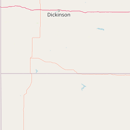
Use this park location map to pinpoint Grand River National Grassland in United States of America, understand its exact geographic position, and read its mapped placement within the surrounding landscape more clearly.

Pigeon | © OpenStreetMap contributors

Location context for Grand River National Grassland

South Dakota

Visualizing the mixed grass prairie, badlands, and river habitats of the northern Great Plains

Grand River National Grassland Photos and Landscape Scenery

Visual documentation captures the varied terrain of Grand River National Grassland, ranging from eroded badlands and sandstone outcrops to rolling mixed grass prairie. Examining these protected area photographs reveals the distinctive landscape character, river forks, and restored habitats that define the northern plains environment.

A wide, eye-level shot of a single bare tree standing in a vast, open grassland under a cloudy sky.

Park atlas

Compare adjacent northern Great Plains reserves and connected regional conservation landscapes

Explore Parks Near Grand River National Grassland and Surrounding Protected Areas

Visitors exploring Grand River National Grassland can browse nearby protected areas and compare similar northern Great Plains ecosystems. Examining these adjacent reserves reveals broader regional topography, including mixed grass prairies and badland formations.
Wildlife reserveNorth Dakota
21 km away#1 closest

Northeast

Cedar River National Grassland: A Protected Prairie Landscape in Southern North Dakota

Mixed-grass prairie geography and regional watershed context

Cedar River National Grassland preserves a representative mosaic of upland plains and rolling hills in southern North Dakota. As part of the wider Dakota Prairie Grasslands, this wildlife reserve provides insight into northern prairie topography and intermittent stream ecosystems that define the regional character of the Great Plains.

Area
27.18 km²
Relief
Lowland
Climate
Temperate
Scope
Terrestrial
Protected landscapeNorth Dakota
64 km away#2 closest

Northwest

Little Missouri National Grassland: Geography and Protected Landscape Context

Exploring North Dakota's expansive badlands and prairie terrain

Spanning over a million acres, Little Missouri National Grassland stands as a massive protected landscape in western North Dakota. This area showcases the complex transition where open mixed-grass prairie meets the eroded, rugged badlands of the Little Missouri River corridor. Home to White Butte, the state's highest point, the grassland offers a unique topographic profile of buttes, canyons, and canyons that defines the region's broader geographic and conservation character.

Area
4,163.34 km²
Established
1960
Relief
Upland
Climate
Temperate
National parkNorth Dakota
112 km away#3 closest

Northwest

Theodore Roosevelt National Park: Mapped Protected Landscape in North Dakota

Explore the geography and protected natural boundaries.

Theodore Roosevelt National Park represents a distinct protected landscape within North Dakota, offering a valuable entry point for exploring its unique geographic setting. This page provides a concentrated view of the park's mapped boundaries and its contribution to regional natural context. It is designed for users seeking detailed atlas-level information and a clear understanding of the park's protected-area status and geographic significance within the United States.

Area
285.08 km²
Established
1978
IUCN
II
Visitors
668.7K annual
National parkSouth Dakota
174 km away#4 closest

South

Badlands National Park: South Dakota's Premier National Park for Atlas Exploration

Explore mapped terrain and protected landscape boundaries.

Badlands National Park stands as a key protected area within the geography of South Dakota, offering a distinct natural landscape for detailed atlas exploration. This National Park's unique terrain and mapped boundaries provide crucial context for understanding regional geography and conservation landscapes. Engage with structured information that highlights the park's geographic identity, making it an essential destination for those seeking to map and comprehend protected natural areas.

Area
982.4 km²
Established
1939
IUCN
II
Visitors
1M annual
Protected areaSouth Dakota
176 km away#5 closest

Southeast

Fort Pierre National Grassland: An Atlas of South Dakota Mixed-Grass Prairie Ecosystems

Exploration of central Great Plains protected terrain and boundaries

Focusing on the authentic mixed-grass prairie of South Dakota, Fort Pierre National Grassland serves as a critical example of northern Plains conservation. Its landscape, marked by sweeping vistas and seasonal wetlands, provides a deep look into the spatial character and ecological heritage of the interior United States. Gain a precise understanding of its boundaries and the surrounding geographic features that define this expansive public land.

Area
469 km²
Relief
Upland
Access
Access unknown
Scope
Terrestrial
Protected landscapeWyoming
216 km away#6 closest

Southwest

Thunder Basin National Grassland: A Protected Landscape in the Wyoming Powder River Basin

Mapping the prairie and sagebrush mosaic of northeastern Wyoming

Thunder Basin National Grassland is a sprawling, federally protected territory in northeastern Wyoming that functions as a critical ecotone between the Great Plains and the Rocky Mountain region. Its landscape is characterized by wide-open vistas, intricate sedimentary bluffs, and diverse habitats shaped by natural disturbance patterns and ongoing grassland management. This record outlines the geography, terrain features, and protected boundaries that define this essential segment of the American West.

Area
2,215.65 km²
Established
1960
Relief
Upland
Climate
Arid
National parkCuster County
223 km away#7 closest

South

Wind Cave National Park: A National Park with Distinct Protected Landscape and Geographic Identity

Explore the mapped terrain and regional context of this US protected area.

Wind Cave National Park represents a key protected area within Custer County, offering users a deep dive into its unique geography and landscape characteristics. As a designated national park in the United States, its mapped boundaries provide crucial context for understanding its ecological and geological significance. This MoriAtlas entry facilitates detailed exploration, focusing on the protected land's identity and its role within the wider regional geography and natural landscape.

Area
136.97 km²
Established
1903
IUCN
II
Visitors
489.4K annual
A pale, minimalist watercolor illustration of a wide, open grassy landscape with soft rolling hills in the background and light green vegetation in the foreground.
Protected landscapeSouth Dakota
About 230 km away#8 closest

South

Buffalo Gap National Grassland: Regional Geography and Protected Prairie Boundaries

Mapping the vast grasslands of southwestern South Dakota

Spanning across four counties in southwestern South Dakota, Buffalo Gap National Grassland serves as a premier example of a working Great Plains landscape. The region is defined by its immense scale, where undulating mixed-grass prairie transitions into striking, chalky badlands. This area is recognized for its vital conservation role, including successful species recovery programs, and stands as a foundational feature of the regional geological and ecological map.

Area
2,410.77 km²
Established
1960
Relief
Upland
Climate
Temperate

Common questions about visiting, size, designation, and location context for Grand River National Grassland

Grand River National Grassland FAQs for park facts, access, geography, and protected area context

Find quick answers about Grand River National Grassland, including protected-area facts, park geography, trail and visitor context, and how the park fits into its surrounding country and regional landscape.
MoriAtlas Explorer

Continue Your Protected Areas Search Across the Global Atlas

Deepen your exploration by continuing the structured search for national parks and protected areas worldwide. Utilize the comprehensive filtering capabilities to compare different conservation landscapes and refine your understanding of global park geography. Discover more about the distribution and characteristics of protected natural areas.

Global natural geography