

Mori Atlas logo
Protected landscapeGreat and Little Sta. Cruz Islands Protected Landscape/Seascape

Integrated island and marine conservation boundaries off the Zamboanga Peninsula.

Great and Little Sta. Cruz Islands Protected Landscape/Seascape and Regional Geography

Great and Little Sta. Cruz Islands Protected Landscape/Seascape encompasses a vital terrestrial and marine environment located off the southern tip of the Zamboanga Peninsula. This protected unit integrates onshore island habitats with surrounding coastal waters, serving as a primary regional anchor for conservation planning and ecological monitoring. Detailed mapping provides insights into the buffer zones and continuous coastal mosaic that define this protected area in Zamboanga del Sur.

islandsmarine protected areacoastal sceneryisland ecosystemstropical marine environmentprotected seascape

Great and Little Sta. Cruz Islands Protected Landscape/Seascape

Protected landscape

Park overview

Structured park overview, official facts, and landscape profile for Great and Little Sta. Cruz Islands Protected Landscape/Seascape

Great and Little Sta. Cruz Islands Protected Landscape/Seascape park facts, protected area profile, and essential visitor context

Review the core facts for Great and Little Sta. Cruz Islands Protected Landscape/Seascape, including designation, size, terrain, visitor scale, habitats, and operating context in one park-focused overview.

About Great and Little Sta. Cruz Islands Protected Landscape/Seascape

The Great and Little Sta. Cruz Islands Protected Landscape/Seascape is a Philippine protected area that bridges terrestrial conservation and marine protection in a single managed zone. It is set off the coast of the Zamboanga Peninsula, the prominent western spur of Mindanao that extends southwest toward the Sulu Sea. The protected area is administratively tied to Zamboanga City, even though it lies within the broader province of Zamboanga del Sur.

The designation covers two small islands, Great Santa Cruz Island and Little Santa Cruz Island, along with their surrounding coastal and marine environment. By combining a protected landscape designation with a protected seascape designation, the management framework acknowledges that the conservation value of these islands depends on the integrity of both the land and the surrounding sea. The seascape component extends the protection outward into the buffer zone, addressing connectivity between the islands and the broader marine ecosystem.

The Sta. Cruz Islands are recognized as one of the prominent natural tourism resources of the Zamboanga Peninsula region. Their proximity to Zamboanga City, combined with their island geography and clean coastal setting, has made them a focal point for nature-based tourism planning. The combined protected-area status supports efforts to maintain environmental quality while enabling structured, sustainable forms of access and visitation.

Quick facts and research context for Great and Little Sta. Cruz Islands Protected Landscape/Seascape

The Great and Little Sta. Cruz Islands Protected Landscape/Seascape is located in the southern Philippines, off the coast of Zamboanga del Sur on the Zamboanga Peninsula of Mindanao. The protected area encompasses Great Santa Cruz Island and Little Santa Cruz Island together with their surrounding waters, and falls within the administrative jurisdiction of Zamboanga City.

Established on 23 April 2000 through Presidential Proclamation No. 271, the area combines terrestrial park protections with seascape, marine, and coastal zone protections. The core protected zone covers 1,877 hectares, with an additional buffer zone of 1,548 hectares extending outward to manage the surrounding sea. The islands form one of several protected natural areas in the Zamboanga Peninsula region.

Protection and recognition

Explore documented conservation scope and formal protected area designation metrics.

Great and Little Sta. Cruz Islands Protected Landscape/Seascape Protection Status

Examine the official protection status, mixed management scope, and verified registry records for Great and Little Sta. Cruz Islands Protected Landscape/Seascape. Designated framework data provides structured insight into conservation boundaries without assuming external recognition sources.

Protection details

Protection scope
Mixed
WDPA ID
306508
Buffer area
15.48 km²
Park context

Deeper park guide and search-rich context for Great and Little Sta. Cruz Islands Protected Landscape/Seascape

Great and Little Sta. Cruz Islands Protected Landscape/Seascape history, landscape, wildlife, and travel context

Explore Great and Little Sta. Cruz Islands Protected Landscape/Seascape through its history, landscape character, ecosystems, wildlife, conservation priorities, cultural context, and seasonal travel timing in a structured park guide built for atlas discovery and search intent.

Why Great and Little Sta. Cruz Islands Protected Landscape/Seascape stands out

The protected area is best known for its dual designation as both a protected landscape and a protected seascape, bringing together small offshore islands and their surrounding marine waters into a single conservation unit. It represents an early example of integrated land-and-sea protection in the southern Philippines. The Sta. Cruz Islands are also recognized as one of the notable natural tourism anchor points of the Zamboanga region. Local and national authorities have formally supported the development of the islands as a destination for high-quality ecotourism, making the area notable for the way conservation planning and tourism strategy have been linked from an early stage.

Great and Little Sta. Cruz Islands Protected Landscape/Seascape history and protected-area timeline

The Great and Little Sta. Cruz Islands Protected Landscape/Seascape was formally established on 23 April 2000 through Presidential Proclamation No. 271. The proclamation created a combined protected landscape and seascape around Great Santa Cruz Island and Little Santa Cruz Island, setting the foundation for integrated management of the islands and their surrounding waters.

In 2011, the Philippine Department of Tourism and the Tourism Infrastructure and Enterprise Zone Authority, working with the city government of Zamboanga City, signaled their support for developing the Sta. Cruz Islands into a premium ecotourism destination. An architectural study was commissioned to guide the design of any future developments and to ensure consistency with environmental and aesthetic goals. A budget of 20 million Philippine pesos was allocated for this initiative.

The area continues to be managed under the National Integrated Protected Area System, the overarching Philippine framework for protected-area governance, linking the islands to the country's broader biodiversity and conservation planning efforts.

Great and Little Sta. Cruz Islands Protected Landscape/Seascape landscape and geographic character

The landscape setting of the protected area is defined by its position just offshore from the southern tip of the Zamboanga Peninsula. The Zamboanga Peninsula is a long, narrow arm of Mindanao reaching southwestward, and the Sta. Cruz Islands sit in the coastal waters near where this peninsula approaches the Sulu Sea.

Great Santa Cruz Island and Little Santa Cruz Island together with their surrounding waters make up the core of the protected landscape and seascape. The dual designation reflects the inseparability of the islands and the sea around them, with sandy shores, intertidal zones, and nearshore waters forming a continuous coastal mosaic. A buffer zone extends the protected area outward into the surrounding marine environment.

Great and Little Sta. Cruz Islands Protected Landscape/Seascape ecosystems, habitats, and plant life

As a combined landscape and seascape protected area, the Sta. Cruz Islands Protected Landscape/Seascape is designed to conserve both island habitats and the adjoining marine environment. The protected status links the ecological condition of the islands to the health of the coastal and nearshore waters, recognizing that the two systems are functionally interdependent.

The area forms part of the broader suite of protected natural assets of the Zamboanga Peninsula region, an area recognized for its mix of coastal, marine, and terrestrial habitats in the southern Philippines.

Great and Little Sta. Cruz Islands Protected Landscape/Seascape conservation status and protection priorities

The protected area is one of several formally designated conservation zones on the Zamboanga Peninsula, standing alongside other protected landscapes, natural biotic areas, and resource reserves across the region. Its combined landscape-and-seascape designation provides a legal and management framework for protecting both the islands and the productivity of the surrounding marine environment, including through the use of a marine buffer zone.

By placing land and sea under a single proclamation-driven management regime, the area serves as a model of integrated coastal conservation in the southern Philippines, helping to preserve ecological connectivity and reduce fragmentation between terrestrial and marine management efforts.

Top sights and standout views in Great and Little Sta. Cruz Islands Protected Landscape/Seascape

The defining feature of the Sta. Cruz Islands Protected Landscape/Seascape is its combined protected landscape and protected seascape status, one of the simpler yet more instructive examples of integrated conservation governance on the Zamboanga Peninsula. The protected area's recognition as a regional tourism anchor, supported by formal ecotourism planning linked to conservation, makes it a useful case study in sustainable destination development.

The buffer-zone arrangement, which adds marine space around the core island territory, also highlights how the Philippine protected-area framework accommodates coastal and marine values alongside traditional terrestrial protections.

Best time to visit Great and Little Sta. Cruz Islands Protected Landscape/Seascape

The protected area's coastal and island setting gives it a tropical maritime climate shaped by the broader weather patterns of the southern Philippines. Sea conditions around the Sta. Cruz Islands tend to be calmer during typical dry-season months, which is also when accessibility by ferry from Zamboanga City is generally more favorable. Visitors interested in coastal scenery, island landscapes, and the marine environment can expect a tropical island atmosphere year-round, with seasonal patterns influencing sea state more than temperature.

Monthly climate preview

Long-term temperature and precipitation records across twelve recorded months of coastal observation

Climate Normals and Monthly Weather Patterns for Great and Little Sta. Cruz Islands Protected Landscape/Seascape

Representative coordinate sampling from nineteen ninety-one to twenty-twenty reveals consistent monthly temperature ranges alongside shifting precipitation volumes across the protected marine terrain. Examining the complete twelve-month record provides deeper perspective on long-term climate normals and seasonal moisture fluctuations.
Annual mean27 °C
27 °C28 °C
Jan27°
Feb27°
Mar28°
Apr28°
May28°
Jun28°
Jul27°
Aug27°
Sep27°
Oct27°
Nov28°
Dec28°
Warmest month
April

28.1 °C

Coolest month
January

27.1 °C

Wettest month
October

6.4 mm/day

Driest month
February

2.4 mm/day

Park location guide

Geography guide, regional context, and park location map for Great and Little Sta. Cruz Islands Protected Landscape/Seascape

Great and Little Sta. Cruz Islands Protected Landscape/Seascape park geography, regions, and map view in Philippines

Understand where Great and Little Sta. Cruz Islands Protected Landscape/Seascape sits in Philippines through a broader geographic reading of the surrounding landscape, nearby location context, and its mapped position within the national park landscape.

How Great and Little Sta. Cruz Islands Protected Landscape/Seascape fits into Philippines

The Philippines, officially the Republic of the Philippines, is an archipelagic nation in Southeast Asia comprising approximately 7,641 islands categorized into three main geographical divisions: Luzon, Visayas, and Mindanao. Located in the western Pacific Ocean, it shares maritime borders with Taiwan, Japan, Palau, Indonesia, Malaysia, Vietnam, and China. Manila serves as the capital city, while Quezon City is the most populated city, both within Metro Manila.

Wider geography shaping Great and Little Sta. Cruz Islands Protected Landscape/Seascape in Philippines

The Philippines is an archipelagic nation in Southeast Asia, positioned in the western Pacific Ocean. Its islands are bounded by the South China Sea to the west, Philippine Sea to the east, and Celebes Sea to the south. The country shares maritime borders with Taiwan to the north, Japan to the northeast, Palau to the east and southeast, Indonesia to the south, Malaysia to the southwest, Vietnam to the west, and China to the northwest.

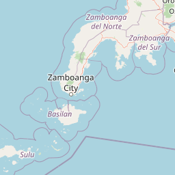
Map view of Great and Little Sta. Cruz Islands Protected Landscape/Seascape

Use this park location map to pinpoint Great and Little Sta. Cruz Islands Protected Landscape/Seascape in Philippines, understand its exact geographic position, and read its mapped placement within the surrounding landscape more clearly.

Pigeon | © OpenStreetMap contributors

Location context for Great and Little Sta. Cruz Islands Protected Landscape/Seascape

Zamboanga del Sur
Park atlas

Compare regional coastal environments and protected areas across the Zamboanga Peninsula.

Exploring Parks Near Great and Little Sta. Cruz Islands Protected Landscape/Seascape

Browsing nearby protected areas allows visitors to examine coastal ecosystems and marine reserves beyond Great and Little Sta. Cruz Islands Protected Landscape/Seascape. Expanding the geographic scope highlights broader regional conservation patterns and connected island landscapes.
Nature reserveBasilan
About 31 km away#1 closest

South

Basilan Natural Biotic Area: A Protected Mountain Nature Reserve on Basilan Island

Understanding the geography of Philippine forest refuges

The Basilan Natural Biotic Area is a designated nature reserve covering significant mountain terrain in the southern Philippines. This protected area features a core zone of primary and secondary rainforest that provides critical habitat for island-endemic birds and functions as a primary hydrological source for the surrounding region.

Area
44.97 km²
Established
2000
Relief
Mountain
Climate
Tropical
Protected landscapeZamboanga del Sur
About 140 km away#2 closest

Northeast

Dumanquilas Protected Landscape/Seascape: Mapping Zamboanga Peninsula Coastal Ecosystems

Integrated Marine and Mangrove Reserve Geography

Dumanquilas Protected Landscape/Seascape functions as a comprehensive conservation reserve combining land and sea. This atlas entry details the geography of a bay-centered ecosystem, highlighting the crucial connection between mangrove forest networks and the extended marine buffer within the Celebes Sea.

Area
259.48 km²
Established
1999
Relief
Lowland
Scope
Mixed
National parkMaguindanao del Norte
About 256 km away#3 closest

East

Mado Hot Spring National Park: Protected Geothermal Landscape in Maguindanao del Norte

Explore its therapeutic hot springs and mapped boundaries

Mado Hot Spring National Park, located in Maguindanao del Norte, Philippines, is a protected area defined by its geothermal features and therapeutic hot springs. This national park, established early in the Philippines' conservation history, offers a unique landscape centered around a warm mineral-rich natural pool. Delve into the geographic context and protected area identity of this distinctive site, understanding its role within the region's natural heritage.

Area
0.48 km²
Established
1939
IUCN
II
Scope
Terrestrial
National parkLanao del Sur
About 278 km away#4 closest

Northeast

Sacred Mountain National Park National Park: Detailed Geographic and Protected Landscape Context

Mapped boundaries and regional geography for Sacred Mountain National Park.

Sacred Mountain National Park, a significant national park in Lanao del Sur, offers a distinct protected landscape for atlas-driven discovery. This detailed entry provides insight into its geographic scope and mapped presence, allowing for a deeper understanding of its role within the region. Explore the specific natural terrain and protected area features that define Sacred Mountain National Park, grounded in factual geographic data.

Area
0.94 km²
Established
1965
IUCN
V
Relief
Mountain
National parkLanao del Sur
About 294 km away#5 closest

Northeast

Lake Butig National Park: National Park Atlas and Geographic Discovery in Lanao del Sur

Discover its mapped boundaries and regional landscape context.

Lake Butig National Park is a protected national park in the Philippines, located within Lanao del Sur. This entry provides specific geographic information and supports atlas exploration by detailing the park's mapped boundaries and its place within the regional landscape. Understand the terrain and protected area context crucial for geographic study and understanding Philippine natural landscapes.

Area
0.68 km²
Established
1965
IUCN
V
Relief
Mountain
National parkLanao del Sur
About 294 km away#6 closest

Northeast

Pantuwaraya Lake National Park: National Park Atlas and Mapped Landscape

Explore the protected area and regional geography of Lanao del Sur.

Understand Pantuwaraya Lake National Park as a defined protected landscape and a significant national park within the Philippines. This entry focuses on its geographic placement in Lanao del Sur, providing context for its mapped boundaries and natural features. Users can explore its representation within a broader atlas of protected lands, gaining insight into its role and landscape identity.

Area
0.2 km²
Established
1965
IUCN
V
Climate
Tropical
National parkLanao del Sur
About 305 km away#7 closest

Northeast

Salikata National Park: Explore Philippines National Park Geography

Mapped protected area boundaries and regional context.

Investigate Salikata National Park, a key protected area designated as a national park within Lanao del Sur, Philippines. This detailed view provides essential context for understanding its mapped boundaries, its place in the regional geography, and its significance as a protected landscape. Discover the unique geographic attributes that define Salikata National Park for atlas-based exploration.

Established
1965
IUCN
V
Relief
Mountain
Climate
Tropical
A horizontal watercolor painting showing a calm lake in the foreground with lush green hills and distant mountain ridgelines in the background.
Protected areaMaguindanao del Sur
About 306 km away#8 closest

East

Lake Buluan Protected Area: An Atlas Guide to Mindanao Lowland Freshwater Landscapes

Geography and hydrological map of the Maguindanao del Sur wetlands.

Lake Buluan represents a vast, shallow freshwater system known for its extensive marshes and role as a central basin for multiple Mindanao river tributaries. As a protected landscape in Maguindanao del Sur, it offers a distinct look at lowland hydrological patterns, floodplain dynamics, and the cultural history associated with the region's inland water resources.

Area
61.34 km²
Relief
Lowland
Water
Water-dominated

Common questions about visiting, size, designation, and location context for Great and Little Sta. Cruz Islands Protected Landscape/Seascape

Great and Little Sta. Cruz Islands Protected Landscape/Seascape FAQs for park facts, access, geography, and protected area context

Find quick answers about Great and Little Sta. Cruz Islands Protected Landscape/Seascape, including protected-area facts, park geography, trail and visitor context, and how the park fits into its surrounding country and regional landscape.
MoriAtlas Explorer

Continue Your Protected Areas Search Across the Global Atlas

Deepen your exploration by continuing the structured search for national parks and protected areas worldwide. Utilize the comprehensive filtering capabilities to compare different conservation landscapes and refine your understanding of global park geography. Discover more about the distribution and characteristics of protected natural areas.

Global natural geography