

Mori Atlas logo
Nature reserveGrenzstreifen zwischen Teistungen und Ecklingerode

Mapping the ecological corridor and geographic heritage of the historic German border region.

Grenzstreifen zwischen Teistungen und Ecklingerode Nature Reserve and Protected Landscape Atlas

(Naturschutzgebiet Grenzstreifen zwischen Teistungen und Ecklingerode)

The Grenzstreifen zwischen Teistungen und Ecklingerode nature reserve represents a significant conservation corridor in Landkreis Eichsfeld, Thuringia. Spanning the former inner German border, this linear protected area preserves an undisturbed mosaic of deciduous beech woodlands, wet grasslands, and open meadows. By tracing the historical frontier through the Eichsfeld basin, this atlas entry provides detailed geographic context on the terrain, elevation, and hydrological features defining this unique sanctuary.

nature reserveGreen Beltformer border corridorThuringiabeech forestwet grassland

Grenzstreifen zwischen Teistungen und Ecklingerode

Nature reserve

Park overview

Structured park overview, official facts, and landscape profile for Grenzstreifen zwischen Teistungen und Ecklingerode

Grenzstreifen zwischen Teistungen und Ecklingerode park facts, protected area profile, and essential visitor context

Review the core facts for Grenzstreifen zwischen Teistungen und Ecklingerode, including designation, size, terrain, visitor scale, habitats, and operating context in one park-focused overview.

About Grenzstreifen zwischen Teistungen und Ecklingerode

Grenzstreifen zwischen Teistungen und Ecklingerode is a dedicated nature reserve that captures a specific, elongated segment of the landscape where the modern state of Thuringia meets the southern border of Lower Saxony. Situated in the Lower Eichsfeld, a basin known for its rolling, hilly topography, the reserve is geographically divided between the broader Hahle valley areas near Teistungen and the North Thuringian Bunter Sandstone Country surrounding Ecklingerode. The protected territory extends across three distinct municipal jurisdictions, anchoring a natural corridor that belongs to one of the most significant transnational ecological networks in Europe.

The physical extent of the reserve follows a winding path dictated by the geography of the former restricted border zone, resulting in a protected strip that is considerable in length but relatively narrow in width. The terrain features several notable ridges and elevations, including the Nonnecke at 338.5 meters, the Bundsenberg reaching up to 310 meters, and the Klosterberg, which stands at approximately 260 meters. Through this varied topography flow smaller watercourses such as the Lindenbeek and the Brehme, which eventually drain into the Hahle river system near the town of Duderstadt. These geographic features contribute to a highly structured environment where different soil conditions and moisture levels support a wide spectrum of plant communities.

A defining aspect of the reserve is its recent ecological maturation, heavily influenced by its historical exclusion from intensive human use. Because the land functioned as a restricted military boundary for decades, the forests here were left to develop naturally, resulting in high volumes of standing and fallen deadwood. This deadwood serves as a critical habitat component for countless species of fungi, insects, and small vertebrates, while the open meadows along the old border patrol routes now harbor specialized grasses and herbaceous plants adapted to nutrient-rich and occasionally flooded soils.

Quick facts and research context for Grenzstreifen zwischen Teistungen und Ecklingerode

Grenzstreifen zwischen Teistungen und Ecklingerode is an IUCN Category IV protected landscape covering roughly 147 hectares in the Lower Eichsfeld region. Established as a formal nature reserve in the year 2000, the area is administered by the Eichsfeld district and lies on the border between Thuringia and Lower Saxony.

The reserve encompasses a narrow, hilly strip of land, typically ranging from 80 to 250 meters in width, and includes notable elevations such as the Nonnecke and the Bundsenberg. Its unique ecological profile is defined by the presence of native beech forests, preserved deadwood, and fragmented wet grasslands that evolved along the former restricted military zone.

Protection and recognition

Examine terrestrial protection details, management parameters, and recorded status data.

Grenzstreifen zwischen Teistungen und Ecklingerode Protection Status and Recognition

Grenzstreifen zwischen Teistungen und Ecklingerode maintains a documented terrestrial protection scope anchored by official database records. Review structured conservation facts and administrative status markers compiled for this protected area.

Protection details

Protection scope
Terrestrial
Transboundary protection
No
WDPA ID
318461
Park context

Deeper park guide and search-rich context for Grenzstreifen zwischen Teistungen und Ecklingerode

Grenzstreifen zwischen Teistungen und Ecklingerode history, landscape, wildlife, and travel context

Explore Grenzstreifen zwischen Teistungen und Ecklingerode through its history, landscape character, ecosystems, wildlife, conservation priorities, cultural context, and seasonal travel timing in a structured park guide built for atlas discovery and search intent.

Why Grenzstreifen zwischen Teistungen und Ecklingerode stands out

The reserve is primarily renowned for its identity as a conservation corridor along the former inner German border, forming a crucial local link in the trans-European Green Belt. Ecologically, it is celebrated for preserving structurally rich beech forests, including Hairy Woodrush and Woodruff beech woodland communities, which are highly valued in European forestry conservation. Furthermore, the area is distinguished by its surviving open-land biotopes, where alternating patches of eutrophic and mesotrophic wet grasslands harbor specialized flora adapted to the historical disturbance regime created by the border militarization.
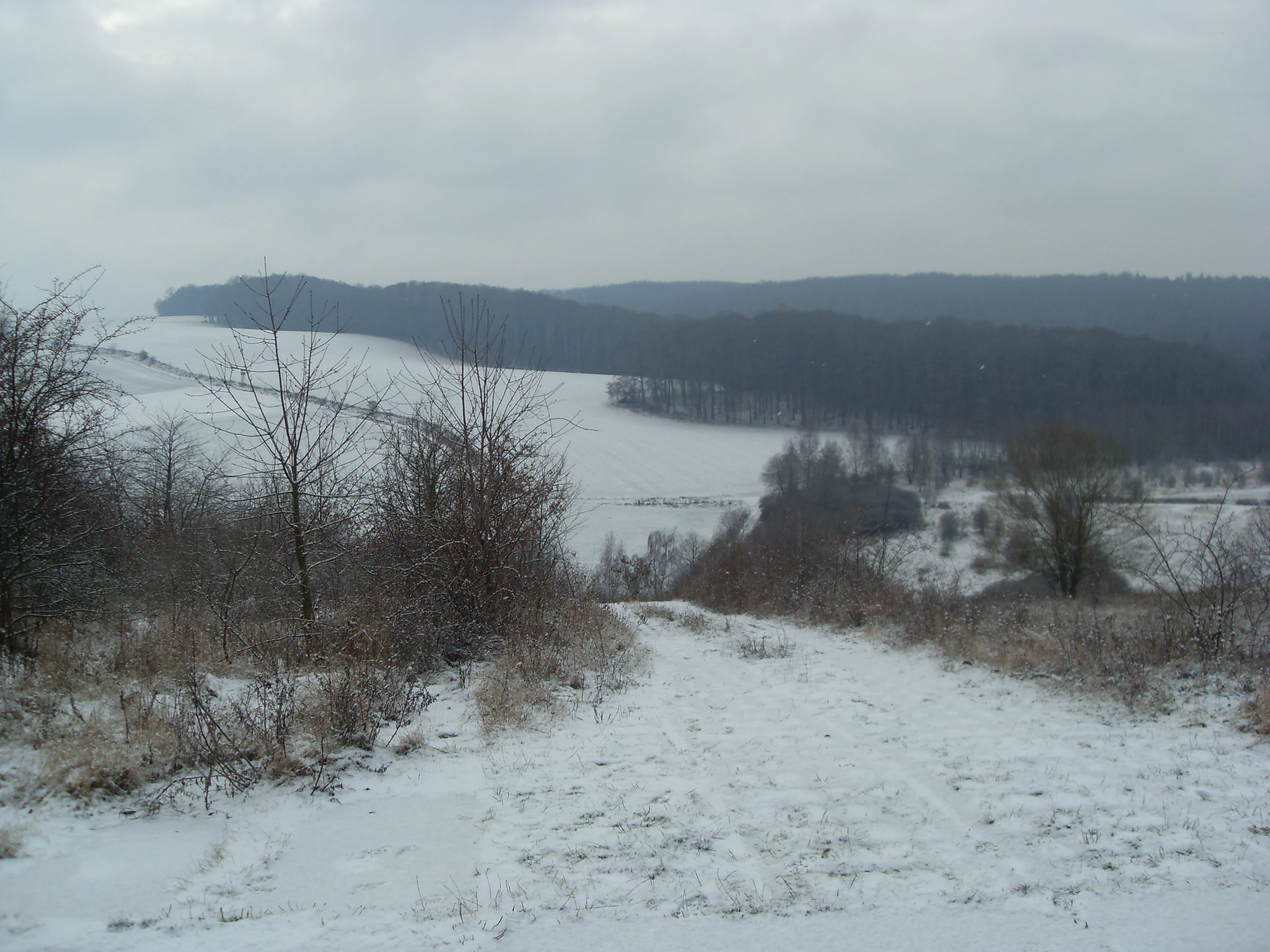
Former border near Ecklingerode
View of the former inner-German border near Ecklingerode, with the Klosterberg or Kutschenberg in the foreground and the Duderstadt forest in the background.

Grenzstreifen zwischen Teistungen und Ecklingerode history and protected-area timeline

The modern nature reserve was formally established and protected in the year 2000, consolidating years of growing environmental awareness following German reunification. Its creation marked a transformative shift in land use, transitioning a landscape that had been heavily militarized and inaccessible during the era of the inner German border into a space dedicated entirely to ecological research and passive conservation.

Today, the area serves as a living monument to this geopolitical history. This heritage is explicitly commemorated by the West-Eastern Gate (West-Östliches Tor) memorial located near Ecklingerode, which preserves the memory of the former border infrastructure for visitors exploring the natural landscapes around it.

Grenzstreifen zwischen Teistungen und Ecklingerode landscape and geographic character

The landscape of the reserve is defined by its elongated geometry and undulating topography, tracing the natural contours of the Eichsfeld basin. The terrain is significantly elevated and folded, establishing a series of microclimates and varied exposures that shape the local vegetation. Small, perennial streams like the Lindenbeek and the Brehme have carved shallow valleys through the region, carrying meltwater and precipitation through the forested hills toward the Hahle valley.

Geologically, the reserve sits within the broader transition zone between the sedimentary layers of the North Thuringian Bunter Sandstone Country and the varied soils of the Eichsfeld basin. The resulting slopes, ridges, and depressions create a natural mosaic of dry, mesic, and wet environments over a relatively short distance. The maximum elevations within the protected borders crest at 338.5 meters on the Nonnecke, while the lowest valleys provide the necessary hydrological inputs to sustain the wet meadows and deciduous woodlands that dominate the regional scenery.

Grenzstreifen zwischen Teistungen und Ecklingerode ecosystems, habitats, and plant life

The ecosystems within this reserve reflect decades of ecological succession under minimal direct human interference. The woodland sections, particularly within the broader Wulfertal area, are predominantly blanketed by native broadleaf canopies. These forests are primarily characterized by European beech, which forms both Hairy Woodrush beech communities on more acidic, loamy soils, and Woodruff beech communities in areas with better nutrient availability.

Interspersed among these natural beech stands are sections of planted spruce and mixed spruce-larch forest, representing earlier forestry practices. Pockets of pioneer birch forest have also established themselves in clearings and transitional zones. A particularly valuable ecological feature is the high concentration of coarse woody debris and standing deadwood, which serves as an essential substrate for forest regeneration, providing moisture retention, shelter, and nutrition for saprophytic life.

In stark contrast to the shaded forests, the open-land biotopes stretch along the historical patrol routes of the old border. Here, a network of mesotrophic and eutrophic grasslands thrives, shifting between fresh, well-drained patches and wetter, occasionally flooded depressions. This combination of dense beech forest and dynamic wet meadow creates a highly productive ecotone, supporting exceptional botanical diversity and providing crucial refuge habitats in a region otherwise dominated by modern agricultural utilization.

Grenzstreifen zwischen Teistungen und Ecklingerode conservation status and protection priorities

The reserve is classified as an IUCN Category IV protected area, functioning primarily as a Habitat and Species Management Area with active environmental oversight. Designated under the broader strategic framework of the European Green Belt initiative, the protected corridor plays an instrumental role in maintaining connectivity between fragmented habitats. By preserving a continuous, undisturbed strip of natural landscape, the reserve allows for the safe movement and genetic exchange of local flora and fauna, effectively insulating them from the heavily modified agricultural zones flanking its borders.

Conservation management focuses heavily on preserving the existing deadwood stocks within the beech forests and maintaining the delicate hydrological balance of the wet grasslands. The alternating wet and dry open areas require careful monitoring to prevent shrub overgrowth, which would inevitably shade out the rare meadow species adapted to the high-light conditions of the former military zone. Through these targeted preservation efforts, the reserve stands as a key reference site for studying the natural regeneration of Central European low mountain landscapes.

Grenzstreifen zwischen Teistungen und Ecklingerode cultural meaning and human context

Beyond its ecological value, the reserve carries immense cultural and historical weight as a preserved segment of the former inner German border. For nearly four decades, the land was entirely off-limits to the local population, serving instead as a militarized frontier that physically divided East and West Germany. The memory of this turbulent era remains embedded in the landscape. The West-Eastern Gate memorial near Ecklingerode is a local landmark dedicated to this history, featuring visible remnants of the border installations and serving as a place of reflection for those visiting the natural surroundings today.

Top sights and standout views in Grenzstreifen zwischen Teistungen und Ecklingerode

A defining feature of the reserve is its remarkable structural diversity, packing a rich array of forest types, watercourses, and meadowlands into a narrow, concentrated corridor. Visitors and researchers are particularly drawn to the old-growth beech woodlands of the Wulfertal valley, which showcase natural forest dynamics through abundant deadwood and undisturbed seed banks.

Just as compelling are the string of open, semi-wet meadows that follow the old border path, offering a rare glimpse into a pre-modern agricultural matrix shaped entirely by natural processes without human interference.


Monthly climate preview

Long term temperature and precipitation patterns recorded across twelve monthly intervals

Grenzstreifen zwischen Teistungen und Ecklingerode Climate Normals And Monthly Weather

Representative coordinates for Grenzstreifen zwischen Teistungen und Ecklingerode capture measured temperature extremes and precipitation rates from nineteen ninety one to twenty twenty. Examining the complete monthly climate profile reveals precise variations in average thermal ranges and daily moisture levels throughout the year.
Annual mean8 °C
-1 °C18 °C
Jan-1°
Feb
Mar
Apr
May12°
Jun16°
Jul18°
Aug18°
Sep14°
Oct
Nov
Dec
Warmest month
July

18.2 °C

Coolest month
January

-0.9 °C

Wettest month
July

2.6 mm/day

Driest month
April

1.5 mm/day

Park location guide

Geography guide, regional context, and park location map for Grenzstreifen zwischen Teistungen und Ecklingerode

Grenzstreifen zwischen Teistungen und Ecklingerode park geography, regions, and map view in Germany

Understand where Grenzstreifen zwischen Teistungen und Ecklingerode sits in Germany through a broader geographic reading of the surrounding landscape, nearby location context, and its mapped position within the national park landscape.

How Grenzstreifen zwischen Teistungen und Ecklingerode fits into Germany

Germany is a federal republic in Western and Central Europe with a population of over 83 million across sixteen constituent states. It is Europe's largest economy by nominal GDP and a major global exporter and importer. The capital is Berlin, and the country borders Denmark, Poland, Czech Republic, Austria, Switzerland, France, Luxembourg, Belgium, and the Netherlands.

Wider geography shaping Grenzstreifen zwischen Teistungen und Ecklingerode in Germany

Germany is located in Western and Central Europe, spanning 357,022 km². It borders Denmark to the north, Poland and the Czech Republic to the east, Austria and Switzerland to the south, and France, Luxembourg, Belgium, and the Netherlands to the west. The country has coastlines on the Baltic Sea and North Sea to the north, with the Alps located in the southern region.

Map view of Grenzstreifen zwischen Teistungen und Ecklingerode

Use this park location map to pinpoint Grenzstreifen zwischen Teistungen und Ecklingerode in Germany, understand its exact geographic position, and read its mapped placement within the surrounding landscape more clearly.

Pigeon | © OpenStreetMap contributors

Location context for Grenzstreifen zwischen Teistungen und Ecklingerode

Landkreis EichsfeldThuringia

Visualizing the terrain, habitats, and protected woodland character of the former border corridor

Grenzstreifen zwischen Teistungen und Ecklingerode Photos and Landscape Scenery

Visual documentation captures the elongated terrain, mixed beech forests, and wet grassland habitats defining Grenzstreifen zwischen Teistungen und Ecklingerode. Photographic records reveal the natural topography and undisturbed ecological zones preserved along the historic frontier.

Former border near Ecklingerode

Park atlas

Compare surrounding regional geography and connected conservation corridors

Parks Near Grenzstreifen zwischen Teistungen und Ecklingerode and Related Protected Landscapes

Explore other protected areas sharing similar regional geography and historical border terrain near Grenzstreifen zwischen Teistungen und Ecklingerode. Continuing across adjacent reserves reveals broader ecological patterns and connected natural landscapes throughout the Eichsfeld basin.
Nature reserveThuringia
About 4.3 km away#1 closest

Southeast

Bodenstein Nature Reserve: Geographic Atlas and Protected Area Context in Thuringia

Limestone escarpments and ravine landscapes of the Eichsfeld

Bodenstein is a protected nature reserve featuring a distinctive limestone escarpment along the Ohmgebirgsplateau. The terrain encompasses a series of hilltops and ravines shaped by geological shifts, serving as a key reference site for the forest ecosystems and spring-fed hydrological networks found across the Thuringia region.

Area
1.335 km²
Established
1961
IUCN
IV
Relief
Upland
Protected areaThuringia
About 14 km away#2 closest

Southeast

Bleicheröder Berge: Geographic Profile and Protected Landscape Context in Thuringia

Mapping the forested ridges and Muschelkalk geology of the Thuringian region.

Investigate the Bleicheröder Berge as a vital protected area in Thuringia. This resource outlines the range's formation as a series of isolated hill remnants, its fossil-bearing limestone cliffs, and the botanical diversity characterizing its beech forests and rare orchid populations.

Area
16 km²
Relief
Mountain
Climate
Temperate
Access
Easy access
Nature reserveThuringia
About 17 km away#3 closest

Northeast

Sülzensee, Mackenröder Wald: A Detailed Look at Thuringia's Protected Nature Reserve

Exploring the beech forest landscapes and stream-carved terrain of northern Thuringia.

Sülzensee, Mackenröder Wald is a protected nature reserve in northern Thuringia known for its expansive beech forests and diverse geological foundation. Spanning over 280 hectares, the area features undulating ridges, deep-cut stream valleys, and a unique position atop the Elbe-Weser watershed. This geography-focused overview details the reserve's status as a corridor for wildlife and its significant role in regional habitat conservation.

Area
2.802 km²
Established
2000
IUCN
IV
Nature reserveLower Saxony
About 17 km away#4 closest

North

Steinberg bei Scharzfeld Nature Reserve: Dolomite Geology and Harz Foothill Geography

A detailed protected-area profile of the dolomite ridge in Lower Saxony.

Steinberg bei Scharzfeld is a protected nature reserve in the southern Harz region, defined by its rare dolomite geology and rugged cliff habitats. This site features exposed rock outcrops, drought-prone calcareous grasslands, and the natural Steinkirche cave monument. It serves as a vital anchor for understanding the ecological diversity of the local karst landscape and its distinct geological character compared to the surrounding mountain environments.

Area
0.14 km²
Established
1988
Relief
Upland
Climate
Temperate
Watercolor illustration of a mountainous landscape with forests and a winding path
National parkLower Saxony
About 20 km away#5 closest

Northeast

Harz National Park: A Mapped Protected Landscape in Lower Saxony's Mountains

Explore geographic boundaries and regional terrain.

Harz National Park is a protected area defined by its unique mountain landscape and extensive forests in Lower Saxony, Germany. This MoriAtlas entry details its geographic scope, allowing for exploration of its mapped boundaries and its place within the regional geography. Understand the terrain, from its highest peaks to its alpine bogs, offering a structured view of this significant protected landscape for atlas-based discovery.

Area
247 km²
Established
2006
IUCN
II
Visitors
4M annual
Nature reserveThuringia
About 21 km away#6 closest

Southeast

Keulaer Wald Nature Reserve: Geographic Overview of the Dün Plateau Forest in Thuringia

Mapped beech-dominated plenterwald and limestone escarpment terrain

Located in northern Thuringia, Keulaer Wald is a designated nature reserve characterized by its continuous beech canopy on shell limestone bedrock. This site serves as a vital protected area within the regional forest belt, offering high-elevation viewpoints over the surrounding Eichsfeld Basin and the distant Harz mountain range.

Area
2.97 km²
Established
1961
Relief
Mountain
Climate
Temperate
Nature reserveThuringia
About 22 km away#7 closest

South

Ibenkuppe Nature Reserve and the Muschelkalk Cuesta Landscapes of Thuringia

Mapped protected woodland and limestone escarpment geography

Located in the Eichsfeld district, Ibenkuppe is a nature reserve that protects a significant Muschelkalk spur. Its geography includes the prominent Abrißwand landslide scar and the deeply cut Rosoppe valley. This site provides a focused look at the intersection of forested limestone slopes and traditional valley pasture fragments in the heart of Germany.

Area
0.292 km²
Established
1997
Relief
Mountain
Scope
Terrestrial
Nature reserveThuringia
About 22 km away#8 closest

Southwest

Lengenberg Nature Reserve: A Geographical Overview of the Eichsfeld Ridge

Protected beech and yew woodlands in Thuringia, Germany

The Lengenberg Nature Reserve forms a prominent, fully forested ridge within the Eichsfeld region of Thuringia. Renowned for hosting one of the most substantial yew populations in central Europe, the reserve showcases a geological transition between shell limestone and red sandstone. This mapping of the terrain provides insight into the ecological structure of the Eichsfeld-Hainich-Werratal area.

Area
0.26 km²
Established
1961
Relief
Mountain
Climate
Temperate

Common questions about visiting, size, designation, and location context for Grenzstreifen zwischen Teistungen und Ecklingerode

Grenzstreifen zwischen Teistungen und Ecklingerode FAQs for park facts, access, geography, and protected area context

Find quick answers about Grenzstreifen zwischen Teistungen und Ecklingerode, including protected-area facts, park geography, trail and visitor context, and how the park fits into its surrounding country and regional landscape.
MoriAtlas Explorer

Continue Your Protected Areas Search Across the Global Atlas

Deepen your exploration by continuing the structured search for national parks and protected areas worldwide. Utilize the comprehensive filtering capabilities to compare different conservation landscapes and refine your understanding of global park geography. Discover more about the distribution and characteristics of protected natural areas.

Global natural geography