Mori Atlas logo
Nature reserveGroßer Horn

Mapped woodland boundaries and ecological terrain in the northern Thuringian Basin.

Großer Horn Nature Reserve and Protected Forest Landscape in Thuringia, Germany

(Naturschutzgebiet Großer Horn)

Großer Horn represents a critical protected woodland complex located on the Heilinger Höhen within the Thuringia region. This nature reserve serves as an ecological reference site, preserving a unique mosaic of subcontinental oak-hornbeam and woodruff beech forests. The landscape is defined by varied soil substrates including loess loam and Muschelkalk, creating a distinctive habitat island within the surrounding agricultural lowlands.

deciduous forestnature reservetotalreservatoak-hornbeam forestbeech forestThuringia

Großer Horn

Nature reserve

Park overview

Structured park overview, official facts, and landscape profile for Großer Horn

Großer Horn park facts, protected area profile, and essential visitor context

Review the core facts for Großer Horn, including designation, size, terrain, visitor scale, habitats, and operating context in one park-focused overview.

About Großer Horn

Großer Horn is a protected woodland of roughly 159 hectares in northern Thuringia, situated at the transition between the Thuringian Basin to the south and the northern uplands. The reserve lies within the Unstrut-Hainich district, with a small portion extending into the Kyffhäuserkreis, and forms part of the Heilinger Höhen landscape, whose southern slope descends toward the Schlotheimer Graben.

The reserve has been legally protected since 1961 under the German Naturschutzgebiet designation, and within it a central zone has been set aside as a totalreservat. Such totalreservats are managed with minimal human interference, allowing natural forest dynamics, deadwood accumulation, and species turnover to proceed largely on their own. This makes Großer Horn a reference site for studying subcontinental mixed deciduous woodland far from the more humid beech forests of Germany's central and western uplands.

Ecologically, the site combines two forest communities that are individually common in central Europe but rarely preserved together at this scale. The subcontinental bedstraw oak-hornbeam forest is associated with warmer, drier lowland and hill landscapes, while the woodruff beech forest represents the more classic Central European beech forest type. Their coexistence at Großer Horn reflects the transitional geographic position of the northern Thuringian Basin. The forest also serves as a habitat island within an agricultural landscape, surrounded by villages such as Freienbessingen, Mittelsömmern, Hornsömmern, Bruchstedt, Blankenburg, Kirchheilingen, and Allmenhausen.

Culturally and historically, the forest contains traces of older land use and political geography. Groups of prehistoric burial mounds are scattered across the reserve, and numerous historical boundary stones once marked the border between the former Kingdom of Prussia's Province of Saxony and the Principality of Schwarzburg-Sondershausen. In the southwestern corner, a particularly old oak is protected as a natural monument. The reserve is also tied to more recent history through a former NVA air-defense rocket site on its northern edge, which was briefly used as asylum-seeker accommodation in the 1990s before being abandoned and gradually reclaimed by the surrounding woodland.

Quick facts and research context for Großer Horn

Großer Horn lies in northern Thuringia within the Unstrut-Hainich-Kreis, with its western edge reaching into the Kyffhäuserkreis. The reserve occupies part of the Heilinger Höhen, between roughly 290 and 350 meters above sea level. It has been formally protected as a Naturschutzgebiet since 1961 and is registered as a totalreservat under WDPA ID 14438, with German code 019.

The core of the reserve is composed of mixed deciduous woodland dominated by subcontinental bedstraw oak-hornbeam forest and woodruff beech forest. Soils include loess loam, clay, and Muschelkalk weathering substrates, which together support a high-water-retention forest floor. The surrounding region carries a dry Börde climate pattern with relatively low annual precipitation.

Protection and recognition

Explore documented protected area records, management scope, and conservation status for Großer Horn.

Großer Horn Protection Status and Terrestrial Conservation Data

Examine the verified terrestrial protection status and administrative records established for Großer Horn. Review structured conservation facts and international database identifiers compiled for this protected area.

Protection details

Protection scope
Terrestrial
Transboundary protection
No
WDPA ID
14438
Park context

Deeper park guide and search-rich context for Großer Horn

Großer Horn history, landscape, wildlife, and travel context

Explore Großer Horn through its history, landscape character, ecosystems, wildlife, conservation priorities, cultural context, and seasonal travel timing in a structured park guide built for atlas discovery and search intent.

Why Großer Horn stands out

Großer Horn is best known as one of the older small-scale forest nature reserves in Thuringia, valued primarily for protecting an isolated complex of oak-hornbeam and beech woodland at the northern rim of the Thuringian Basin. Its core status as a totalreservat, meaning a strict no-intervention zone for natural forest dynamics, makes it a reference site for subcontinental deciduous forest research. The reserve also stands out for its unusually rich soil mosaic. Deep loess loam in the north transitions into clay, loam, and weathered Muschelkalk toward the south, producing a patchwork of base-rich and base-poor conditions within a compact area. This substrate diversity, combined with the dry Thuringian Börde climate, supports a fine-grained pattern of woodland communities that would not typically occur together in such a small forest.
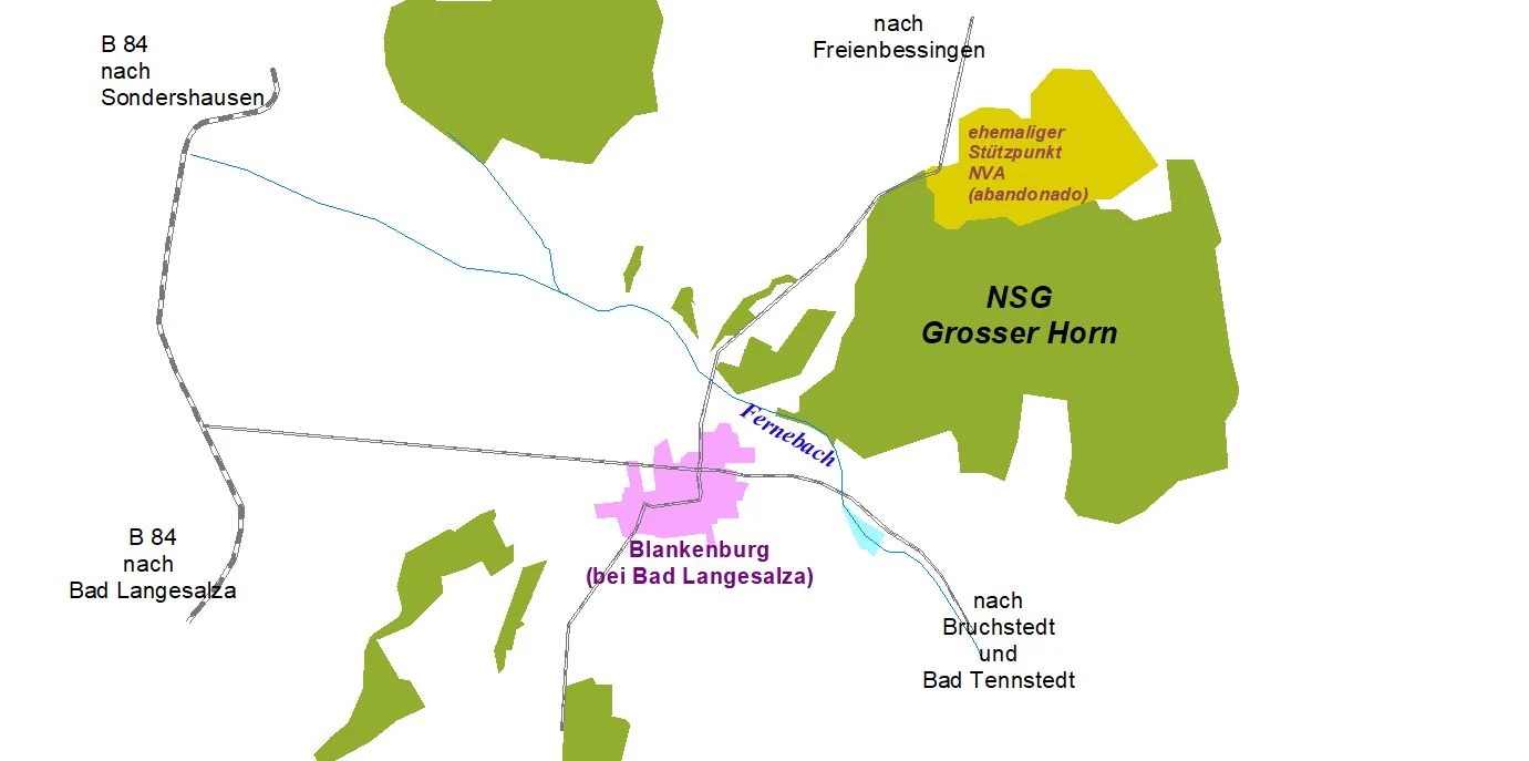
A digital map illustrating the geographic boundaries of the NSG Grosser Horn nature reserve, including adjacent roads, local towns like Blankenburg, and water features.
Map showing the location of the Großer Horn nature reserve in relation to nearby towns and road networks.

Großer Horn history and protected-area timeline

Großer Horn has been formally protected as a Naturschutzgebiet since 1961, making it one of the longer-standing forest nature reserves in Thuringia. Its designation reflects mid-twentieth-century German conservation practice focused on identifying isolated, ecologically meaningful woodland patches and securing them against continued agricultural pressure. The central part of the reserve was later set aside as a totalreservat, a strictly protected core in which forestry and other interventions are largely excluded to allow the forest to develop under natural dynamics.

The reserve also carries several layers of non-ecological history. Prehistoric burial mounds scattered through the woodland suggest that the area has been used and regarded as significant land for millennia. Numerous surviving boundary stones mark the former border between the Prussian Province of Saxony and the Principality of Schwarzburg-Sondershausen, an older political frontier that pre-dates modern German state boundaries and reflects the complex small-state geography of historical Thuringia.

In more recent decades, the reserve's edge was marked by a military site. In the early 1970s, an NVA air-defense rocket position was constructed on the northern part of Großer Horn near Blankenburg, operating from 1975 as FRA 192 within the Warsaw Pact alert system. After reunification, parts of the former military site served briefly as asylum-seeker housing between 1992 and 2007. Since then, the abandoned facility has been left to merge back into the surrounding woodland, adding another layer to the reserve's changing land-use history.

Großer Horn landscape and geographic character

Großer Horn occupies a gently undulating hill landscape on the Heilinger Höhen, the southern slope of which descends toward the Schlotheimer Graben. The reserve sits between roughly 290 and 350 meters above sea level, placing it relatively low in altitude but with enough relief to create distinct slope exposures, especially on its southern flank facing into the broader Thuringian Basin.

Geologically, the site sits on a varied substrate. Northern parts of the forest are dominated by deep loess loam, a wind-deposited sediment that produces highly fertile and water-retentive soils. Toward the south, loess thins out and gives way to clay, loam, and weathered Muschelkalk, a Triassic limestone whose chemical weathering supplies base-rich substrates. The mixture of soils produces strong root penetration, stable water retention, and an unusually fine-grained ecological pattern for such a compact area.

The broader landscape context is one of intensive agriculture surrounding an isolated forest island. Großer Horn appears as a wooded patch framed by fields and villages, with the federal road B84 to the west and the L1027 to the south. The surrounding lowlands belong to the Börde climate zone, characterized by relatively low precipitation and warm summers, which extends a comparatively open, dry landscape character right up to the edge of the forest.

Großer Horn ecosystems, habitats, and plant life

The defining ecological feature of Großer Horn is the coexistence of two contrasting deciduous forest types within a small area. The subcontinental bedstraw oak-hornbeam forest is characteristic of warmer, drier lowland regions in eastern and central Europe, with oak and hornbeam forming the canopy over a herb layer typically rich in bedstraw species. By contrast, the woodruff beech forest represents the classical Central European beech ecosystem, with beech dominating the canopy over a forest floor marked by woodruff and similar mesic herbs.

Their coexistence at Großer Horn is tied to climate as well as soils. The reserve lies at the margin between sub-Atlantic and subcontinental climatic influences, in the dry Börde belt of northern Thuringia with annual precipitation around 515 millimeters and a mean annual temperature near 7.8°C. Variation in slope, exposure, and substrate across the small forest means that microclimates shift quickly, allowing types that would normally be found in different regions to sit next to each other.

The high soil fertility, particularly in the loess-rich northern parts, supports strong root development and good water retention. Because the woodland has been largely allowed to develop naturally within the core zone, the reserve accumulates deadwood, structural complexity, and microhabitats that support forest-interior species. Surrounding agricultural land supplies an open-landscape contrast that heightens the forest's role as a habitat island for woodland-dependent flora and fauna.

Großer Horn wildlife and species highlights

Großer Horn's wildlife character reflects its status as an isolated deciduous forest island embedded in an agricultural landscape. The woodland interior, with its dense canopy, deep leaf litter, and undisturbed deadwood within the totalreservat core, supports species associated with mature Central European forests. Snags, fallen logs, and old-growth structures provide nesting and feeding substrates for woodpeckers, hole-nesting birds, bats, saproxylic beetles, and a range of fungi-dependent invertebrates.

The surrounding farmland matrix means that edge effects are significant. Open-country bird species, small mammals, and insects associated with field margins and forest edges interact with the forest community, producing a mixed faunal profile for visitors and researchers who work the reserve. Old trees, including a particularly old oak protected as a natural monument in the southwestern corner, serve as long-term habitat features for cavity-nesting species and the slow-developing communities of large veteran trees.

Because the reserve is small and primarily valued for its forest vegetation and structure, the documented wildlife profile is closely tied to woodland community dynamics rather than to charismatic large mammals or breeding bird concentrations. The site's value for fauna lies in its continuity as undisturbed forest habitat rather than in any single flagship species.

Großer Horn conservation status and protection priorities

Großer Horn has been protected as a Naturschutzgebiet since 1961, with its central area designated as a totalreservat in which natural forest dynamics are allowed to proceed without forestry intervention. Within this core, the combination of subcontinental oak-hornbeam forest and woodruff beech forest is preserved as it naturally develops, including deadwood accumulation and natural regeneration cycles.

The reserve's conservation value rests on its role as an isolated reference site. In a region heavily shaped by agriculture, Großer Horn preserves a forest community that would otherwise have been replaced or fragmented. Its registration under the World Database on Protected Areas, with WDPA ID 14438, places it within the international framework of protected-area records, while its national code 019 links it to the Thuringian system of small forest reserves.

Beyond its strict ecological protection, the reserve is associated with a broader vision of low-impact, sustainable tourism. Surrounding agricultural land continues to produce fertile soils, but within the reserve the wooded area is recognized as a stabilizing influence on the local water cycle, helping to buffer the dry Börde climate and counter erosion processes affecting nearby farmland.

Großer Horn cultural meaning and human context

Großer Horn is more than an ecological site: it carries a layered cultural and historical significance. Groups of prehistoric burial mounds scattered through the woodland indicate that the area was important to earlier communities and likely marked by ritual or territorial use long before recorded history.

The forest also bears visible political history. Numerous boundary stones preserved within the reserve once marked the border between the former Kingdom of Prussia's Province of Saxony and the Principality of Schwarzburg-Sondershausen. These stones reflect the fragmented, small-state political geography of historical Thuringia, where multiple principalities, counties, and ecclesiastical territories met within short distances.

A particularly old oak in the southwestern corner of the reserve is protected as a natural monument, marking the human recognition of single old trees as part of communal and natural heritage. The name Großer Horn itself, also rendered colloquially as Großes Hornholz, derives from the Old High German word for damp or swampy land, hinting at older perceptions of the site as a distinctive wooded and water-influenced landscape.

Top sights and standout views in Großer Horn

Long-standing 1961 nature reserve status and a strict totalreservat core for unmanaged forest development.

Unusual coexistence of subcontinental oak-hornbeam forest and woodruff beech forest on a single small site.

Diverse soil mosaic of loess loam, clay, and weathered Muschelkalk supporting dense forest root systems.

Position at the climatic transition between sub-Atlantic and subcontinental influences in the northern Thuringian Basin.

Cultural layers including prehistoric burial mounds, historic Prussian-Schwarzburg boundary stones, and a protected veteran oak.

Recovery of a former NVA air-defense site back into woodland, showing post-military landscape regeneration.

Best time to visit Großer Horn

Großer Horn is essentially a quiet, low-traffic deciduous forest reserve in an agricultural region, and the experience is shaped by the seasons in a temperate Central European way. Spring brings fresh leaf-out, understory flowering, and active bird song in the canopy. Summer offers dense, shaded forest interior with strong contrasts against the surrounding open farmland. Autumn is the most visually striking period, with the oak-hornbeam and beech communities turning in mixed tones of yellow, rust, and brown over deep loamy soils. Winter exposes the structure of the woodland, making it easier to read the rolling terrain, exposed soils on slopes, and the site's place within the broader agricultural landscape.


Monthly climate preview

Track representative annual temperature ranges and monthly precipitation patterns

Großer Horn Climate Normals and Long Term Weather by Month

Long term climate data for Großer Horn records annual temperature variations from subzero winter minimums to warm summer maximums alongside steady precipitation rates. Reviewing the complete monthly profile provides deeper analytical insight into multi year meteorological baselines across the protected area.
Annual mean8 °C
-1 °C18 °C
Jan-1°
Feb
Mar
Apr
May12°
Jun16°
Jul18°
Aug18°
Sep14°
Oct
Nov
Dec
Warmest month
July

18.4 °C

Coolest month
January

-1.3 °C

Wettest month
July

2.6 mm/day

Driest month
April

1.4 mm/day

Park location guide

Geography guide, regional context, and park location map for Großer Horn

Großer Horn park geography, regions, and map view in Germany

Understand where Großer Horn sits in Germany through a broader geographic reading of the surrounding landscape, nearby location context, and its mapped position within the national park landscape.

How Großer Horn fits into Germany

Germany is a federal republic in Western and Central Europe with a population of over 83 million across sixteen constituent states. It is Europe's largest economy by nominal GDP and a major global exporter and importer. The capital is Berlin, and the country borders Denmark, Poland, Czech Republic, Austria, Switzerland, France, Luxembourg, Belgium, and the Netherlands.

Wider geography shaping Großer Horn in Germany

Germany is located in Western and Central Europe, spanning 357,022 km². It borders Denmark to the north, Poland and the Czech Republic to the east, Austria and Switzerland to the south, and France, Luxembourg, Belgium, and the Netherlands to the west. The country has coastlines on the Baltic Sea and North Sea to the north, with the Alps located in the southern region.

Map view of Großer Horn

Use this park location map to pinpoint Großer Horn in Germany, understand its exact geographic position, and read its mapped placement within the surrounding landscape more clearly.

Pigeon | © OpenStreetMap contributors

Location context for Großer Horn

Thuringia

Visual reference collection highlighting protected woodland terrain and ecological character.

Großer Horn Photos and Landscape Views: Exploring Forest Scenery and Habitats

Visual documentation reveals the undulating hill terrain, dense canopy structures, and diverse soil mosaics that shape the protected forest environment. Studying these landscape views helps researchers and visitors understand the natural development zones and microclimates sustained within the reserve.

A digital map illustrating the geographic boundaries of the NSG Grosser Horn nature reserve, including adjacent roads, local towns like Blankenburg, and water features.

Park atlas

Compare adjacent woodland reserves and regional protected landscapes

Parks Near Großer Horn and Protected Areas in the Surrounding Region

Browsing other parks near Großer Horn reveals connected woodland ecosystems across the northern Thuringian Basin. Protected-area comparison highlights regional ecological patterns and adjacent deciduous forest habitats.
Nature reserveThuringia
About 11 km away#1 closest

Southeast

Herbslebener Teiche Nature Reserve: Mapping the Wetland Mosaic and Floodplain Geography

A critical protected wetland and floodplain landscape in central Thuringia, Germany.

Herbslebener Teiche encompasses a varied landscape of reed beds, ponds, and riparian zones within the Unstrut river basin. This nature reserve provides essential habitat structure through its complex arrangement of fallow land, sedge meadows, and open water bodies, marking it as a significant protected entity in the Thuringia region.

Area
0.993 km²
Established
2000
Relief
Lowland
Climate
Temperate
A watercolor painting showing a panorama of soft green rolling hills and meadows under a hazy, pale sky.
Nature reserveThuringia
About 16 km away#2 closest

West

Grabsche Berge Nature Reserve: Thuringia Protected Hill and Cuesta Geography

Steppe-like terrain within the Thuringian Basin

The Grabsche Berge nature reserve encompasses a series of low hills forming a notable cuesta landscape in central Germany. This protected area provides a focal point for understanding dry grassland vegetation and geological transitions on the edge of the Unstrut floodplain, offering a distinct botanical and environmental study site in the heart of the Thuringian Basin.

Area
0.544 km²
Established
1996
A horizontal watercolor illustration depicting soft green rolling hills and a forested ridge against a pale white background.
Protected landscapeThuringia
About 17 km away#3 closest

South

Fahner Höhe Protected Landscape: Geography and Natural Terrain of the Thuringian Basin

Mapped limestone ridge and woodland protected area in central Germany

Fahner Höhe stands as a significant geological landmark in Thuringia, characterized by its long, narrow Muschelkalk ridge. The area features dense oak-hornbeam forests, deep erosional features like the Imtalgraben, and a rich variety of spring flora. As a designated protected landscape and Natura 2000 site, it offers a distinct contrast to the surrounding lowland basin, serving as a vital natural asset for the regional geography.

Area
26 km²
Relief
Upland
Climate
Temperate
Access
Easy access
Watercolor painting of a green, rolling valley with muted pastel tones.
Nature reserveThuringia
About 20 km away#4 closest

West

Flachstal Nature Reserve: Geographic Profile and Protected Valley Landscapes in Thuringia

Ecologically rich calcareous dry valley and protected habitat mosaic

Flachstal represents a significant nature reserve within Thuringia, defined by its steep flanks of Muschelkalk limestone and centuries of traditional sheep grazing. This dry valley functions as both a hotspot for grassland species and a vital climate corridor for the surrounding plateau. The site offers an opportunity to study the intersection of geological history, fossil-rich streambeds, and modern conservation management within the Natura 2000 network.

Area
1.876 km²
Established
1999
IUCN
IV
Relief
Upland
Watercolor illustration of a landscape featuring green fields, trees, a river, and distant hills under a pale sky
National parkThuringia
About 21 km away#5 closest

Southwest

Hainich National Park: Protected Ancient Beech Forest Landscape in Thuringia, Germany

Regional geography and primeval forest boundaries

Hainich National Park occupies 75 square kilometers of the larger Hainich forest in western Thuringia. This canonical protected area is defined by its ancient beech woodland and ongoing forest restoration processes. The geography of the region, situated between Eisenach and Bad Langensalza, provides a critical example of primary forest dynamics and central European biodiversity, serving as an anchor for environmental research and landscape analysis.

Area
75 km²
Established
1997
IUCN
II
Climate
Temperate
A watercolor painting of a rolling, forested landscape with soft green and pink tones, featuring gentle hills and vegetation.
National parkThuringia
About 21 km away#6 closest

Southwest

Nationalpark Hainich: Exploring the Geography of Thuringia's Beech Forest Wilderness

Mapped protected landscapes in the German heartland

Nationalpark Hainich protects one of the most important remaining deciduous woodlands in Central Europe. This detailed atlas entry covers the park's rolling terrain, the transition of its former training grounds into wild forest, and the geographic context of its position within the broader Thuringian landscape.

Area
75 km²
Established
1997
Relief
Upland
Climate
Temperate
Nature reserveThuringia
About 23 km away#7 closest

North

Wöbelsburg Nature Reserve: Protected Plateau Landscapes and Geography in Thuringia, Germany

Mapped shell limestone escarpment and Iron Age hillfort site.

Wöbelsburg offers a focused look at the rugged Muschelkalk terrain characteristic of the northwestern Hainleite. As a protected nature reserve, the site features a prominent mountain spur that drops steeply toward the Wipper lowland, providing a clear example of geological undercutting and plateau formation in central Germany.

Area
0.659 km²
Established
1961
Relief
Upland
Water
Minor water
Nature reserveThuringia
About 23 km away#8 closest

North

Westliche Hainleite Nature Reserve: Mapping the Protected Ridgeline Landscapes of Northern Thuringia

A study of forest escarpments, erosional valleys, and Natura 2000 ecological connectivity

Westliche Hainleite is a protected nature reserve in Thuringia defined by its steep ridgeline escarpments and transitionary geography between the Hainleite range and the Dün hills. This area preserves a mosaic of woodland, cliff, and slope habitats, maintaining essential ecological continuity across the northern German hill country. Its topography is characterized by deep erosional gullies and named summits like Der Berg, which create a distinctive vertical profile within the regional landscape.

Area
9.459 km²
Established
2004
IUCN
IV

Common questions about visiting, size, designation, and location context for Großer Horn

Großer Horn FAQs for park facts, access, geography, and protected area context

Find quick answers about Großer Horn, including protected-area facts, park geography, trail and visitor context, and how the park fits into its surrounding country and regional landscape.
MoriAtlas Explorer

Continue Your Protected Areas Search Across the Global Atlas

Deepen your exploration by continuing the structured search for national parks and protected areas worldwide. Utilize the comprehensive filtering capabilities to compare different conservation landscapes and refine your understanding of global park geography. Discover more about the distribution and characteristics of protected natural areas.

Global natural geography