
Mori Atlas logo
Protected landscapeGulf Islands National Seashore

Mapping the barrier island terrain, historic fortifications, and coastal ecosystems of this sprawling southern seashore.

Gulf Islands National Seashore: A Detailed Map and Geographic Portrait of Coastal Protected Lands

Gulf Islands National Seashore represents a vast protected landscape spanning the northern Gulf of Mexico, connecting the Florida Panhandle with quiet Mississippi barrier islands. This atlas entry examines the geologic structure of the region, from brilliant white quartz-sand beaches and dune systems to the maritime forests and salt marshes that define its coastal boundaries. The protected area preserves a complex network of historic fortifications and undeveloped wilderness, serving as a critical study in shifting coastal terrain and marine conservation.

barrier islandsGulf of Mexiconational seashorecoastal beacheswhite sand beachesmaritime forts
A graphic illustration depicting a canyon with a winding river running between layered rocky cliffs, surrounded by green trees in the foreground.

Gulf Islands National Seashore

Protected landscape

Park overview

Structured park overview, official facts, and landscape profile for Gulf Islands National Seashore

Gulf Islands National Seashore park facts, protected area profile, and essential visitor context

Review the core facts for Gulf Islands National Seashore, including designation, size, terrain, visitor scale, habitats, and operating context in one park-focused overview.

About Gulf Islands National Seashore

Gulf Islands National Seashore is one of the largest and most visited protected coastal landscapes in the United States, stretching in fragments along roughly 160 miles of northern Gulf of Mexico shoreline across three states. Rather than forming a single contiguous block, the seashore is a mosaic of mainland units, offshore islands, forts, and small nature preserves, all sharing the underlying identity of the northern Gulf's barrier island system.

The Florida portion of the seashore is the most heavily visited and most developed for recreation. It includes the Fort Pickens area at the western tip of Pensacola Beach, the Perdido Key area with the Johnson Beach day-use site, the Naval Live Oaks Reservation on the mainland near Gulf Breeze, and the Okaloosa Island area at Fort Walton Beach. Together these units offer developed swimming beaches, family-friendly campgrounds, nature trails, and an unusually rich concentration of historic military architecture, from colonial-era masonry forts through American coastal artillery installations that defended Pensacola Bay during both world wars.

The Mississippi portion of the seashore has a much more primitive character. The Davis Bayou Area near Ocean Springs is the only Mississippi unit accessible by automobile, while Petit Bois, Horn, East Ship, West Ship, and Cat islands can only be reached by boat. These islands preserve wide, largely undeveloped beaches, active dune systems, and long stretches of maritime forest and salt marsh, with portions of Petit Bois and Horn Island protected inside the Gulf Islands Wilderness.

Across all of its districts, the seashore safeguards an unusual geological record: thin layers of Holocene-age beach and dune sand resting on far older Pleistocene and Neogene deposits, capped by the trademark bright quartz sands of the northern Gulf. The result is a national seashore that ranges from lively, family-oriented beach destinations to nearly untouched barrier island wilderness, all bound together within a single National Park Service unit.

Quick facts and research context for Gulf Islands National Seashore

Gulf Islands National Seashore was authorized on January 8, 1971, and is administered by the U.S. National Park Service as a protected landscape and seascape. It stretches across three states: Florida, Alabama, and Mississippi, with the bulk of its protected acreage concentrated in Escambia, Santa Rosa, and Okaloosa counties in the Florida Panhandle and in Jackson and Harrison counties along the Mississippi coast.

The seashore combines mainland units with parts of seven barrier islands: Santa Rosa Island, Perdido Key, Petit Bois, West Petit Bois, Horn Island, East Ship Island, West Ship Island, and Cat Island. A portion of Petit Bois and a portion of Horn Island together form the 4,080-acre Gulf Islands Wilderness, while the famous bright white sands of Pensacola Beach, Perdido Key, and the surrounding Florida barrier islands define the park's signature coastal geology.

Protection and recognition

Examine documented protection levels and official management frameworks for coastal conservation zones.

Gulf Islands National Seashore Protection Status and Management Scope

Gulf Islands National Seashore brings together documented protection status, mixed management scope, and verified designation records for coastal conservation analysis. Official administrative frameworks provide structured baseline metrics for evaluating regional protected area boundaries.

Protection details

Protection scope
Mixed
Transboundary protection
No
Park context

Deeper park guide and search-rich context for Gulf Islands National Seashore

Gulf Islands National Seashore history, landscape, wildlife, and travel context

Explore Gulf Islands National Seashore through its history, landscape character, ecosystems, wildlife, conservation priorities, cultural context, and seasonal travel timing in a structured park guide built for atlas discovery and search intent.

Why Gulf Islands National Seashore stands out

Gulf Islands National Seashore is best known for its brilliant white quartz-sand beaches along the Florida Panhandle, whose color comes from Appalachian-derived quartz that has traveled hundreds of miles down major river systems before being worked along the Gulf shoreline. The park is equally recognized for its chain of historic coastal fortifications, including Fort Pickens, Fort Barrancas, and the World War-era batteries of the Perdido Key Historic District, which together trace more than a century and a half of American coastal defense. Equally distinctive are the more remote Mississippi barrier islands, several of which are only accessible by boat and hold the Gulf Islands Wilderness, a federally protected area that preserves shifting dunes, maritime forests, and miles of undeveloped Gulf-side beaches far from the more crowded Florida districts.
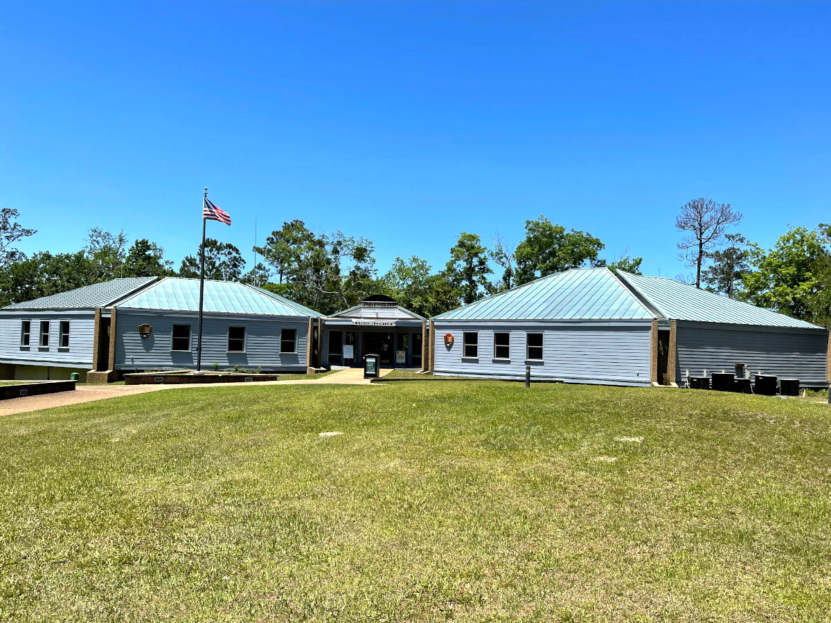
A low-profile visitor center building with grey siding and a metal roof surrounded by green grass under a clear blue sky, featuring a flagpole with an American flag.
The Davis Bayou Area Visitor Center at Gulf Islands National Seashore in Ocean Springs, Mississippi.

Gulf Islands National Seashore history and protected-area timeline

Gulf Islands National Seashore was authorized by Congress on January 8, 1971, after sustained efforts to protect the rapidly developing coastline of the northern Gulf of Mexico. Before that authorization, parts of what is now the seashore had already received federal attention: Santa Rosa Island was protected as a national monument between 1939 and 1946, an early designation that helped establish the precedent for the broader seashore that would follow.

Long before the park itself existed, much of the land it now protects carried a layered military history. Fort Pickens, Fort Barrancas, and the batteries of the Perdido Key Historic District were built, rebuilt, and rearmed across several generations, and they saw service during the Civil War, the Spanish-American War, and both World Wars. These fortifications remain defining landmarks within the seashore and are actively interpreted for visitors.

In more recent decades, the seashore's history has been shaped by major environmental events. The 2004 and 2005 Atlantic hurricane seasons caused extensive damage to roads, campgrounds, and visitor facilities, which were subsequently repaired. The 2010 Deepwater Horizon oil spill drove oil and tar onto nearly every major island in the group, prompting temporary closures and long-term restoration work. Hurricane Sally in September 2020 again reshaped parts of Perdido Key, flattening large sections of dune and prompting ongoing sand and vegetation restoration efforts along the affected shoreline.

Gulf Islands National Seashore landscape and geographic character

The landscape of Gulf Islands National Seashore is defined by one of the youngest and most dynamic coastal systems in North America. The barrier islands that form the backbone of the seashore began forming roughly 4,500 to 5,400 years ago, and they continue to shift, erode, and rebuild in response to storms, sea-level change, and longshore currents along the open Gulf.

On the seaward side of these islands, the surf zone gives way to broad beaches backed by dune ridges that on average rise about 6 feet and can reach up to around 20 feet in protected or older sections. Their brilliant white color comes from quartz grains ultimately derived from the Appalachian Mountains. On the bay or sound side, the islands are typically lower and gentler, edged by salt marshes, tidal flats, and brackish bays that connect the Gulf to inland estuaries such as Pensacola Bay and Mississippi Sound.

Beneath the thin Holocene veneer lies a far older geological sequence. On Santa Rosa Island, modern beach and dune sands rest unconformably on Pleistocene-age deposits from the Sangamonian interglacial, when sea levels stood several meters higher than they do today. These older layers include the Gulfport barrier complex, the Prairie nearshore and estuarine deposits, and the Biloxi floodplain alluvium, which in turn overlie the Pliocene Pensacola Clay and Oligocene-age limestones. On Horn Island, the modern sands instead cap Miocene-age deposits of the Pascagoula, Hattiesburg, and Catahoula formations.
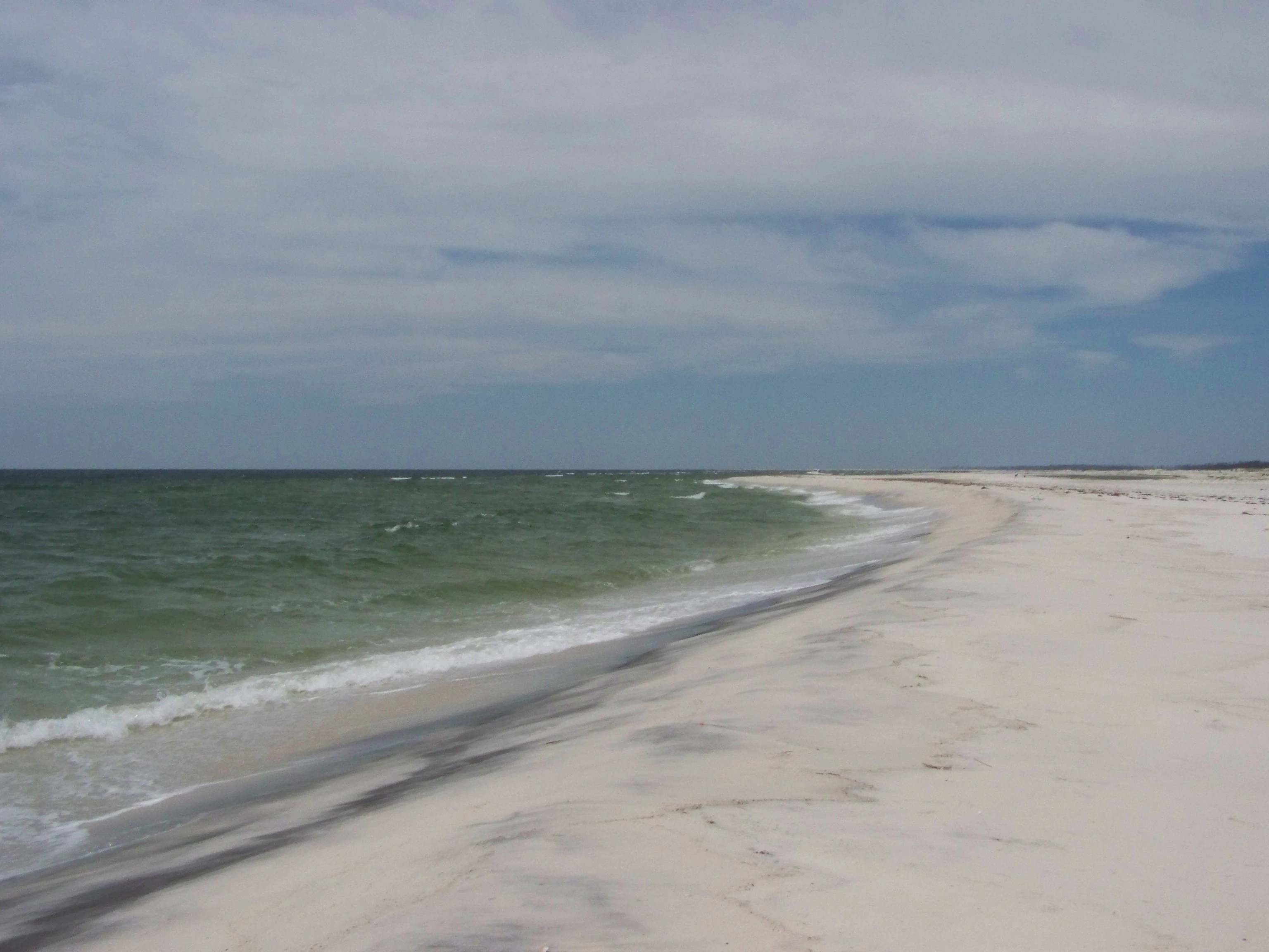
A wide angle view of a white sand beach meeting the green Gulf of Mexico water under a partly cloudy sky.
A view of the sandy coastline at Horn Island within the Gulf Islands National Seashore.

Gulf Islands National Seashore ecosystems, habitats, and plant life

The ecosystems of Gulf Islands National Seashore span a wide range of coastal habitats, from the scrub oak and remnant pine forests on the Florida barrier islands to the oak and pine forests shading the brackish bayous of Mississippi and the open dune and beach systems of the outer islands. Together, these habitats form a rich gradient of salt-tolerant vegetation, maritime woodland, and freshwater wetland communities shaped by sandy soils, salt spray, and recurrent storm disturbance.

The Florida barrier island units combine open beach and dune habitat with interior scrub dominated by sand scrub oaks and live oaks, interspersed with isolated pockets of pine that survive in the thin, sandy soils. Around Naval Live Oaks on the mainland near Gulf Breeze, the landscape shifts toward a denser maritime forest rooted in one of the earliest experimental tree plantings in American conservation history.

The Mississippi portions of the seashore add a quieter and often more ecologically intact layer, with bayous, salt marshes, and the interior forests of Cat, Horn, and Petit Bois islands. Because these more remote districts see far less development and far fewer visitors, they preserve natural processes such as storm overwash and dune migration that have largely been suppressed on the more developed barrier islands elsewhere along the northern Gulf.
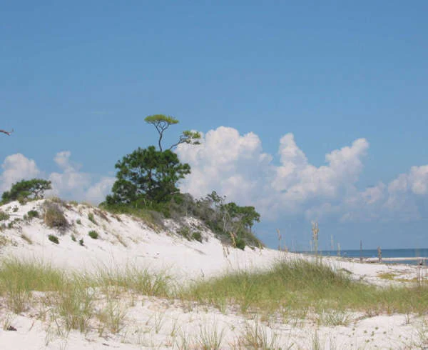
A view of white sand dunes covered with patches of green grasses and pine trees under a blue sky with fluffy white clouds, with a glimpse of the ocean in the distance.
White sand dunes and coastal vegetation at Gulf Islands National Seashore.

Gulf Islands National Seashore wildlife and species highlights

The barrier islands and mainland units of Gulf Islands National Seashore host important habitat for a wide variety of shorebirds, seabirds, songbirds, and nearshore marine life. The remote Mississippi islands, especially Horn and Petit Bois, are well known for their value to migratory and beach-nesting birds, while the bayous and salt marshes around the Davis Bayou Area support typical Mississippi Sound communities of fish, blue crabs, oysters, and waterbirds.

The open Gulf waters surrounding the seashore sustain dolphins, sea turtles, and a diverse community of nearshore fish and shellfish. On land, the maritime forests and scrub communities of every district provide shelter for small mammals, reptiles, and seasonal migrants moving along the northern Gulf coast, with the undeveloped Mississippi islands offering some of the least disturbed terrestrial wildlife habitat on this stretch of shoreline.

Gulf Islands National Seashore conservation status and protection priorities

The conservation significance of Gulf Islands National Seashore lies both in its scale and in the diversity of coastal habitats protected under a single management framework. The 4,080-acre Gulf Islands Wilderness, covering portions of Petit Bois and Horn islands, provides the strongest layer of protection, preserving barrier island ecosystems largely free from development, motorized access, and permanent infrastructure.

The seashore also plays a critical role in conserving the geological and ecological legacy of the northern Gulf of Mexico, from Appalachian-derived quartz sand beaches to the Apalachicola- and Pascagoula-influenced coastal estuaries that bracket its mainland units. Through its mix of federal ownership, partnerships, and long-running restoration projects, the National Park Service uses the seashore to safeguard historic fortifications, endangered species habitat, and the long-term integrity of barrier islands that are otherwise being rapidly altered by coastal development and rising seas.

Gulf Islands National Seashore cultural meaning and human context

The cultural landscape of Gulf Islands National Seashore reflects layers of military, colonial, and early federal conservation history. The forts of Pensacola Bay and Perdido Key preserve more than two centuries of strategic coastal defense, from early American fortifications to active World War I and World War II batteries that still stand within the Perdido Key Historic District and around Fort Pickens.

Alongside this military heritage, the Naval Live Oaks Reservation commemorates one of the country's earliest federal efforts at managed forestry and conservation on public land. Together, these cultural anchors help frame the seashore not only as a natural landscape but also as a long-standing American commitment to protecting coastlines, military memory, and the working landscapes that connect them.

Top sights and standout views in Gulf Islands National Seashore

Among the most compelling highlights of Gulf Islands National Seashore are the bright white quartz-sand beaches of the Florida Panhandle, the cluster of nineteenth and early twentieth century forts that frame Pensacola Bay, and the undeveloped, boat-access barrier islands of Mississippi that hold the Gulf Islands Wilderness. The diversity of access, from family-friendly campgrounds and paved day-use areas to primitive island camping reachable only by boat or on foot, gives the seashore an unusually broad appeal for both casual beachgoers and more adventurous travelers.

Best time to visit Gulf Islands National Seashore

Thanks to its mild northern Gulf climate, Gulf Islands National Seashore can be visited throughout the year, but spring and fall are generally the most comfortable seasons. Winter brings mild temperatures and lower rainfall, spring offers warming weather and active wildlife, and fall delivers similar conditions alongside smaller crowds. Summers can be hot and humid, with frequent thunderstorms and a clearly elevated hurricane risk from late summer into early autumn.
Monthly climate preview

Monthly temperature ranges and precipitation averages recorded at representative coordinates

Gulf Islands National Seashore Climate Normals and Annual Weather Patterns

Long-term data from 1991 to 2020 documents measured monthly temperature and precipitation variation across the protected terrain of Gulf Islands National Seashore. Examining the complete twelve-month record reveals detailed annual climate normals for this coastal coordinate.
Annual mean20 °C
12 °C28 °C
Jan12°
Feb13°
Mar16°
Apr19°
May24°
Jun27°
Jul28°
Aug28°
Sep26°
Oct21°
Nov16°
Dec13°
Warmest month
July

27.9 °C

Coolest month
January

11.6 °C

Wettest month
July

5.8 mm/day

Driest month
October

3.1 mm/day

Park location guide

Geography guide, regional context, and park location map for Gulf Islands National Seashore

Gulf Islands National Seashore park geography, regions, and map view in United States of America

Understand where Gulf Islands National Seashore sits in United States of America through a broader geographic reading of the surrounding landscape, nearby location context, and its mapped position within the national park landscape.

How Gulf Islands National Seashore fits into United States of America

The United States of America is a federal presidential republic and one of the world's largest countries by area and population. It consists of 50 states across a vast territory spanning multiple time zones, with its capital in Washington, D.C. and largest city in New York City. The nation has a diverse economy, influential political system, and significant cultural and military presence globally.

Wider geography shaping Gulf Islands National Seashore in United States of America

The United States occupies a vast territory in North America, bordered by Canada to the north and Mexico to the south. The 48 contiguous states stretch from the Atlantic to the Pacific Ocean, while Alaska occupies the northwestern region and Hawaii is an archipelago in the Pacific. The country encompasses diverse terrain including the Rocky Mountains, Appalachian Mountains, Great Plains, and extensive river systems.

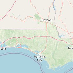
Map view of Gulf Islands National Seashore

Use this park location map to pinpoint Gulf Islands National Seashore in United States of America, understand its exact geographic position, and read its mapped placement within the surrounding landscape more clearly.

Pigeon | © OpenStreetMap contributors

Location context for Gulf Islands National Seashore

FloridaMississippi

Visualizing barrier islands, white quartz sand beaches, and historic coastal fortifications across the Gulf Coast

Gulf Islands National Seashore Photos, Landscapes, and Coastal Scenery

Visual documentation reveals the dynamic terrain of barrier islands, shifting coastal dunes, and maritime forests spanning multiple protected districts. Examining park photography provides clear insight into shoreline geology, tidal habitats, and the distinct natural character of the northern Gulf of Mexico.

A low-profile visitor center building with grey siding and a metal roof surrounded by green grass under a clear blue sky, featuring a flagpole with an American flag.

A wide, eye-level shot of a bright white sand beach meeting the turquoise water of the Gulf of Mexico under a clear sky with scattered clouds.

A wide angle view of a white sand beach meeting the green Gulf of Mexico water under a partly cloudy sky.

A view of white sand dunes covered with patches of green grasses and pine trees under a blue sky with fluffy white clouds, with a glimpse of the ocean in the distance.

Park atlas

Compare adjacent protected landscapes and regional coastal geography across the Gulf Coast

Explore Parks Near Gulf Islands National Seashore and Surrounding Coastal Reserves

Browse other parks near Gulf Islands National Seashore to examine connected barrier island ecosystems and regional protected areas. Comparing neighboring coastal reserves provides a broader perspective on northern Gulf of Mexico terrain and dynamic marine environments.
A horizontal watercolor painting depicting a flat, green coastal marsh with distant purple hills under a pale sky.
Wildlife reserveMississippi
About 19 km away#1 closest

West

Grand Bay National Estuarine Research Reserve: Mississippi Coastal Protected Area Geography

Mapping estuarine ecosystems and coastal forest mosaics

Focusing on the interface between the Mississippi Sound and terrestrial habitats, this reserve protects a vital expanse of estuarine waters, oyster reefs, and pine savanna. Its geography highlights the dynamic interaction of tidal channels, shoreline erosion, and fire-dependent ecosystems within the broader Gulf of Mexico coastal region.

Area
74 km²
Established
1999
IUCN
IV
Relief
Lowland
Watercolor painting of a meandering river flowing through a green marshland with rolling hills in the background under a pale sky.
Nature reserveFlorida
About 170 km away#2 closest

East

Apalachicola National Estuarine Research Reserve: Florida Protected Estuary and Coastal Geography

Exploring the tidal marshes and benthic habitats of Florida's Gulf Coast.

Apalachicola National Estuarine Research Reserve offers a deep look into the coastal geography of the Florida panhandle. As a protected area, it manages the complex intersection of estuarine food chains, commercial fishing zones, and vital wetland habitats, utilizing advanced GIS capabilities to map the bay's submerged reefs and tidal channels.

Relief
Lowland
Climate
Subtropical
Scope
Marine
Water
Water-dominated
Protected landscapeMississippi
213 km away#3 closest

West

Homochitto National Forest: Mapping the Protected Landscapes of Southwestern Mississippi

Regional forest geography and landscape documentation.

Investigate the unique landscape of Homochitto National Forest, an extensive protected area in Mississippi defined by its loess-country topography and managed pine forests. This entry provides essential mapping context and geographic data for those examining the role of this forest within the broader Southeastern United States ecological network and its CCC-rooted heritage.

Area
776.34 km²
Established
1936
Relief
Upland
Scope
Terrestrial
Protected landscapeMacon County
About 247 km away#4 closest

Northeast

Tuskegee National Forest: A Protected Landscape in Macon County, Alabama

Mapped geography and forest terrain in the American South

Tuskegee National Forest represents a concentrated pocket of protected land in Macon County, Alabama. As the smallest national forest in the country, it provides a dense network of trails and stream terraces that demonstrate how compact forests sustain regional biodiversity and outdoor recreation.

Area
45.54 km²
Established
1959
Relief
Upland
Climate
Subtropical
Protected landscapeMississippi
307 km away#5 closest

Northwest

Tombigbee National Forest: Geographic Atlas and Protected Landscape Overview

Mapping the forest terrain and regional watershed in Mississippi

Tombigbee National Forest represents a complex protected landscape divided into two non-contiguous sections across northeastern Mississippi. From the pine-and-hardwood ridges of its northern unit to the reservoir-anchored southern portion, the forest offers a detailed case study in regional topography and watershed management within the southeastern United States.

Area
271.16 km²
Established
1959
Relief
Upland
Climate
Subtropical
Protected landscapeAlabama
About 310 km away#6 closest

North

Talladega National Forest: Geography and Protected Appalachian Forest Maps

Mapping Alabama high country and southern Appalachian forest recovery

Talladega National Forest is a primary protected landscape in Alabama, offering a detailed look at the transition from central pine-oak ridges to northeastern mixed mesophytic hardwood slopes. This forest manages a diverse range of terrain, including the highest peaks in the state, and represents a major achievement in regional ecological restoration across hundreds of thousands of acres of federally protected land.

Area
1,588.66 km²
Established
1936
Relief
Mixed relief
Climate
Temperate
A watercolor painting showing a soft, stylized landscape with rolling green hills, a small river or stream, and a hazy sky at sunrise or sunset.
Protected landscapeFlorida
325 km away#7 closest

East

Osceola National Forest: Mapping the Protected Landscapes and Geography of Northeast Florida

Pine flatwoods, cypress swamps, and historic wilderness terrain

Osceola National Forest serves as a protected landscape in northeast Florida, defined by its extensive pine flatwoods and cypress-hardwood swamp mosaics. The forest provides vital habitat for wildlife like the Florida black bear and red-cockaded woodpecker, while preserving significant historical narratives. Its geography, marked by low elevations and slow-moving water, creates an expansive natural environment for ecological observation and regional exploration.

Area
772.67 km²
Established
1931
Relief
Lowland
Climate
Subtropical
Watercolor painting of a mountain landscape with soft layers of green hills, trees, and a foreground area, rendered in a pale and minimalist style.
Wildlife reserveAlabama
390 km away#8 closest

North

Dugger Mountain Wilderness: Mapping Alabama's Appalachian Ridge and Forest Landscapes

Protected mountain terrain and regional Appalachian geography

Dugger Mountain Wilderness acts as a primary anchor for ecological preservation in Alabama. This wildlife reserve preserves over 9,000 acres of steep, roadless ridges near the Appalachian margin. By studying the topographic boundaries and forest cover of this area, observers can better understand the regional mountain characteristics and the critical role this terrain plays in maintaining intact, uninterrupted natural corridors.

Area
37 km²
Established
2000
IUCN
Ib
Relief
Mountain

Common questions about visiting, size, designation, and location context for Gulf Islands National Seashore

Gulf Islands National Seashore FAQs for park facts, access, geography, and protected area context

Find quick answers about Gulf Islands National Seashore, including protected-area facts, park geography, trail and visitor context, and how the park fits into its surrounding country and regional landscape.
MoriAtlas Explorer

Continue Your Protected Areas Search Across the Global Atlas

Deepen your exploration by continuing the structured search for national parks and protected areas worldwide. Utilize the comprehensive filtering capabilities to compare different conservation landscapes and refine your understanding of global park geography. Discover more about the distribution and characteristics of protected natural areas.

Global natural geography