
Why Gülper See stands out
The Gülper See is primarily known as one of the most significant waterbird gathering places in inland Germany. In spring and autumn, flocks of bean geese and white-fronted geese numbering in the tens of thousands use the lake and its surrounding wet meadows as a staging area, while increasing numbers of common cranes roost on the lake in the evening, often accompanied by whooper swans, ducks, waders, cormorants, white-tailed and ospreys, red and black kites, and marsh harriers. Beyond the bird spectacle, the lake is notable for its distinctive hydrology: a shallow, open-water lake with broad reed belts and extensive fen vegetation, surrounded by grazed grasslands and wet meadows rather than dense forest. This openness, combined with stable water levels managed through historic weirs, gives the site an unusually exposed, lowland character that supports the complete succession of fen and lakeshore plant communities.
Gülper See history and protected-area timeline
The Gülper See originated as a glacial lake at the end of the Weichselian ice age, when meltwater carved a depression at the junction of the Eberswalde and Berlin glacial spillways. Throughout the post-glacial period, the basin accumulated fine organic sediments, particularly gyttja-type half-decomposed mud in the western, northern, and northeastern parts of the lake, while gradual shallowing and plant succession created the broad reed belts that fringe it today. The floodplain setting between the Havel and Rhin rivers has shaped centuries of water-level management, and the landscape still bears the imprint of historical structures such as the Gahlberg needle weir and the former lock basin near the Gülpe boat lock.
Formal protection arrived in 1967, when the area around the lake was designated as a nature reserve. The reserve, originally smaller than its current extent, has since been expanded and now covers roughly 970 hectares around the lake. The Gülper See also became a central element of the Westhavelland Nature Park, the largest protected area in Brandenburg, and was recognized internationally alongside the Lower Havel floodplain as a Ramsar site of international importance for waterbirds. A major ownership milestone occurred on 5 August 2009, when the lake and additional surrounding land were transferred to the NABU National Natural Heritage Foundation, anchoring its long-term conservation in dedicated nonprofit stewardship.
Gülper See landscape and geographic character
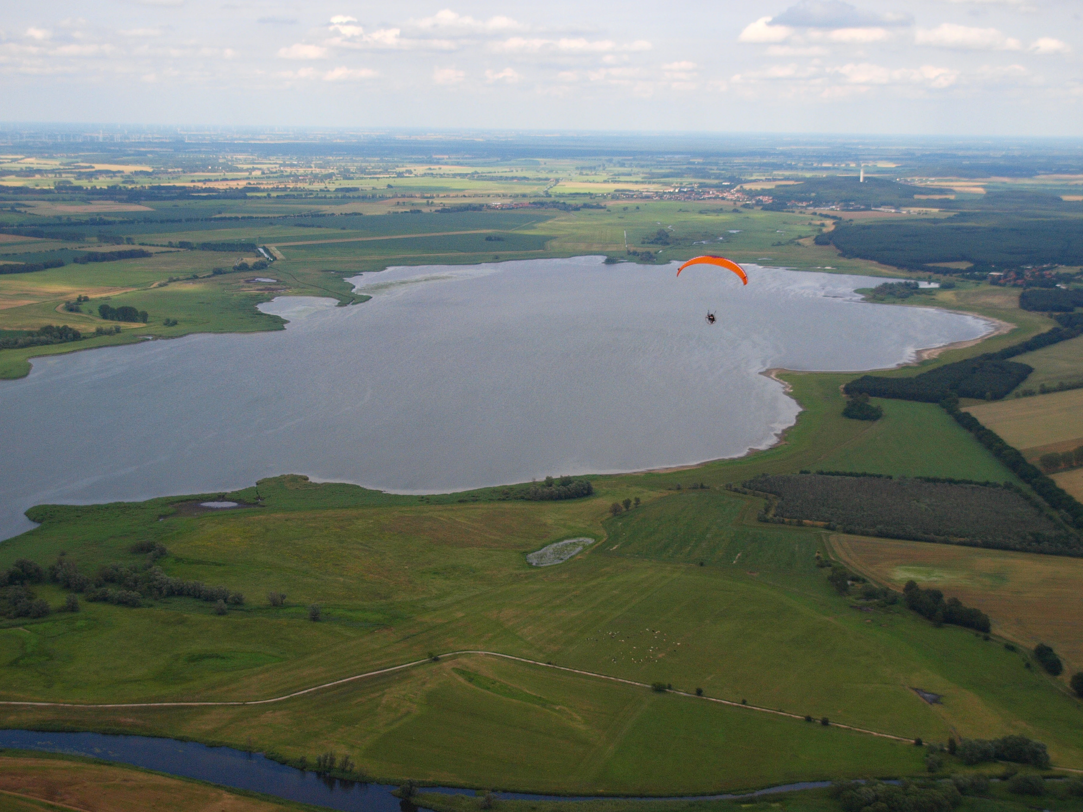
The Gülper See is set in an exceptionally flat and open lowland landscape typical of the Westhavelland. The lake surface itself is broad and shallow, with maximum depths of only about three meters near the outflow and an average depth of roughly one to one and a half meters. Sediment-rich basins along the western, northern, and northeastern shores are bordered by extensive reed belts, while the southeastern and southern fringes transition gently into dry, extensively grazed grasslands and nutrient-poor meadow vegetation. Together with surrounding wet meadows, isolated willows and poplars, and pine forests to the south, the lake presents a much more open character than most other waterbodies in the region, with views extending across the water and into the floodplain.
Hydrologically, the landscape is closely tied to the broader Havel and Elbe water regimes. Because the surrounding land lies only slightly above the average water level of the Havel and the local gradient of the Havel and Rhin is very gentle, prolonged flooding events regularly affect the meadows and fields around the lake. The water level of the Gülper See is regulated primarily by the historic Gahlberg needle weir, with a second control weir in the former lock basin near the Gülpe boat lock. These structures, along with the broader floodplain dynamics, are essential to maintaining the seasonal flooding pulses that shape the reed belts and wet meadows.
Gülper See ecosystems, habitats, and plant life
Vegetation around the Gülper See reflects the transition from open water through reed, fen and meadow communities into drier grassland and small patches of woodland. Broad reed belts, characterized as Röhricht, line the lake in its western, northern and northeastern sections, accompanied by substantial deposits of gyttja sediments. Toward the south and southeast, the shore grades into extensively grazed grassland and species-poor, low-nutrient meadows, while the broader landscape is dominated by wet meadows with isolated fields, willows, poplars, and southern pine forests.
The lake itself has undergone notable ecological change. Until roughly twenty-five years ago, it was a clear-water lake rich in aquatic plants; since then, increased nutrient input has converted it into a turbid lake with strong phytoplankton development, often producing algal blooms and summer visibility of less than fifty centimeters. Despite this shift, the lake's shoreline vegetation remains a notable botanical feature, including a complete successional sequence of low-fen and lakeshore plant communities on its western and eastern sides, which is considered a floristic particularity of the site.
Gülper See wildlife and species highlights
The wildlife profile of the Gülper See is dominated by waterbirds and seasonal migration. In spring and autumn, flocks of white-fronted geese and bean geese stage on the lake and its surrounding meadows in numbers reaching tens of thousands. Common cranes use the site increasingly as a communal nighttime roost, and in October 2006 nearly 10,000 cranes were counted there; the sound and spectacle of cranes flying in at dusk from all directions has become a defining experience of the area.
The lake and its margins also regularly host whooper swans, numerous duck and wader species, cormorants, white-tailed eagles, ospreys, red and black kites, marsh harriers, bitterns, corn buntings, whinchats, penduline tits, and bearded tits. These species are drawn by the combination of open water, reed cover, and undisturbed wet meadows. On the broader floodplain, the rich birdlife supports conservation work by the NABU foundation and the Westhavelland Nature Park, and the site is considered one of the inland crane and goose hotspots of northeastern Germany.
Gülper See conservation status and protection priorities
The Gülper See has been at the center of formal nature protection in Brandenburg since 1967, when the surrounding area was designated as a nature reserve. Today, the lake forms the core of the 970-hectare Gülper See nature reserve, which is in turn part of the Westhavelland Nature Park, the largest protected area in Brandenburg and a recognized dark-sky park. Together with the Lower Havel floodplain, the lake is officially recognized as a Ramsar wetland of international importance because of its exceptional value as a breeding and staging area for waders, geese, ducks, and cranes.
Since 5 August 2009, the lake and additional surrounding land have been owned and managed by the NABU National Natural Heritage Foundation, which pursues long-term conservation, ecological monitoring, and careful public access. Conservation work focuses on maintaining the hydrological regime through structures like the Gahlberg needle weir, protecting reed belts and wet meadows, and managing the lake's nutrient inputs to address the shift from clear-water conditions to phytoplankton-dominated turbidity. The site's conservation significance extends well beyond local boundaries, contributing to the network of internationally important waterbird sites along the Havel and Elbe corridors.
Gülper See cultural meaning and human context
The Gülper See and its surroundings carry cultural traces of long-standing interaction between people and a floodplain landscape. Water management structures such as the Gahlberg needle weir and the historic boat lock near Gülpe reflect centuries of effort to balance navigation, flood control, and land use along the Havel and Rhin systems. The surrounding villages of Gülpe, Prietzen, Kietz, and Strodehne belong to the municipality of Havelaue and represent a traditional rural landscape of small settlements framed by meadows and waterways rather than dense forest.
Traditional extensive grazing has shaped parts of the lakeshore, producing the species-rich dry grassland and low-nutrient meadow vegetation that characterizes the southern and southeastern edges of the lake. In the modern era, the cultural value of the area is increasingly tied to nature observation and quiet landscape tourism, particularly seasonal visits to witness the evening crane flights, which has become a shared local and regional identity element for the Westhavelland.
Top sights and standout views in Gülper See
The Gülper See combines an exceptionally open lowland lake landscape with one of inland Germany's most important waterbird concentrations. Its reed-fringed, shallow basin functions as a Ramsar-recognized migration hotspot, hosting tens of thousands of geese in spring and autumn and an ever-growing communal roost of common cranes whose dusk flights define the area for visitors.
Equally distinctive is the way conservation layers overlap here: a 1967 nature reserve expanded to about 970 hectares, embedded in the Westhavelland Nature Park with its dark-sky designation, and placed under nonprofit stewardship through the NABU National Natural Heritage Foundation since 2009. Combined with hydrological heritage such as the Gahlberg weir, the site unites ecology, water management, and cultural landscape history into a coherent protected-area experience.
Best time to visit Gülper See
The character of a visit to the Gülper See is shaped strongly by the seasons because the lake's wildlife significance is concentrated during migration periods. Spring and autumn are the most distinctive times: the lake and its surrounding meadows regularly host tens of thousands of staging white-fronted geese and bean geese, while autumn evenings bring the largest communal crane roosts and the well-known dusk flight spectacle as cranes approach the lake from all directions.
Summer tends to bring warmer conditions, lower water clarity due to phytoplankton development, and rich aquatic vegetation along the reed belts, while winter can offer quieter waterbird observation with overwintering ducks, swans, and raptors such as white-tailed eagles. Because the lake lies in an open floodplain, weather and water levels in the Havel system strongly influence the experience from year to year, so visitors interested in the full migration spectacle typically plan around the spring and autumn windows.