

Mori Atlas logo
Nature reserveHacks Lagoon Conservation Park

A vital freshwater lagoon and Ramsar-recognized habitat on the Limestone Coast of South Australia

Hacks Lagoon Conservation Park: Mapping Wetland Geography and Protected Landscape Boundaries

Hacks Lagoon Conservation Park acts as a crucial protected wetland island within the agricultural landscape of South Australia. This nature reserve, centered on a permanent freshwater lagoon, forms a core segment of an internationally significant wetland system. The protected terrain features a mosaic of marshes, reed beds, and seasonally inundated floodplains that provide essential refuge for diverse waterbird populations.

wetlandsfreshwater lagoonwaterbirdsRamsar siteLimestone Coastconservation park

Hacks Lagoon Conservation Park

Nature reserve

Park overview

Structured park overview, official facts, and landscape profile for Hacks Lagoon Conservation Park

Hacks Lagoon Conservation Park park facts, protected area profile, and essential visitor context

Review the core facts for Hacks Lagoon Conservation Park, including designation, size, terrain, visitor scale, habitats, and operating context in one park-focused overview.

About Hacks Lagoon Conservation Park

Hacks Lagoon Conservation Park is a dedicated wetland conservation reserve on the Limestone Coast of South Australia. Although modest in size, it plays an outsize ecological role by protecting a freshwater lagoon and associated wetland habitat within a broader landscape that has been extensively modified for agriculture. The park lies close to Naracoorte, a regional centre better known for its World Heritage-listed fossil caves, but the conservation park belongs to a very different ecological story, one centred on water, birdlife, and wetland processes.

The protected area is formally classified as an IUCN Category IV reserve, which reflects its purpose of managing specific habitats and species rather than preserving a broad wilderness landscape. The lagoon and its fringing vegetation represent the core conservation values of the park, providing a stable refuge for waterbirds and other wetland fauna in a region where natural wetland habitat has otherwise been heavily reduced.

Since 1985, Hacks Lagoon has formed part of the internationally recognised Bool and Hacks Lagoons Ramsar site, an acknowledgement that elevates the park's significance well beyond its local footprint. The Ramsar listing is reserved for wetlands of recognised ecological, hydrological, or botanical importance and confirms the wetland's standing as a conservation priority at a national and global level. Together, these features make Hacks Lagoon Conservation Park a focused but ecologically meaningful component of South Australia's protected-area network.

Quick facts and research context for Hacks Lagoon Conservation Park

Hacks Lagoon Conservation Park is located in South Australia within the locality of Bool Lagoon, near the town of Naracoorte on the Limestone Coast. The park covers approximately 2 square kilometres and is managed by the South Australian Department for Environment and Water.

The park was first given protected status in 1967 and was formally constituted as a conservation park in 1972 under the National Parks and Wildlife Act 1972. Together with the adjoining Bool Lagoon Game Reserve, it forms part of the Ramsar-listed Bool and Hacks Lagoons wetland complex. It is also classified as an IUCN Category IV protected area and was previously listed on the Register of the National Estate.

Protection and recognition

Documented terrestrial protection scope and official recognition details

Hacks Lagoon Conservation Park Protection Status and Designation Records

Terrestrial protection status records for Hacks Lagoon Conservation Park compile official designation history and management scope details. Systematic conservation data outlines the established governance framework without implying unverified international recognitions.

Protection details

Protection scope
Terrestrial
Park context

Deeper park guide and search-rich context for Hacks Lagoon Conservation Park

Hacks Lagoon Conservation Park history, landscape, wildlife, and travel context

Explore Hacks Lagoon Conservation Park through its history, landscape character, ecosystems, wildlife, conservation priorities, cultural context, and seasonal travel timing in a structured park guide built for atlas discovery and search intent.

Why Hacks Lagoon Conservation Park stands out

Hacks Lagoon Conservation Park is best known for being part of the Bool and Hacks Lagoons Ramsar site, a wetland system recognised internationally for its importance to waterbirds and freshwater habitat conservation. The park centres on a permanent freshwater lagoon surrounded by seasonally inundated wetland vegetation, making it a notable refuge for waterbird species in a predominantly agricultural landscape. The wetland complex stands out in South Australia because of the contrast between its protected aquatic habitat and the surrounding cleared farmland of the Limestone Coast. This setting gives the conservation park a strong identity as a bird-focused wetland reserve rather than a typical bushland or rocky-landscape park.

Hacks Lagoon Conservation Park history and protected-area timeline

Land that now forms Hacks Lagoon Conservation Park was first given protected status on 8 June 1967. On that date, the area was simultaneously declared as a fauna reserve under the Fauna Conservation Act, 1964 to 1965 and as a Fauna Conservation Reserve under the Crown Lands Act, 1929 to 1967, together with additional land in adjacent sections.

In 1972, the area took on its current identity. On 27 April 1972, land in section 249 was reconstituted under the National Parks and Wildlife Act 1972 as the Hacks Lagoon Conservation Park. Subsequent additions followed, with land in sections 373, 379, 382, and 383 incorporated into the conservation park on 27 August 1992, gradually shaping the reserve into its present form.

The broader wetland complex received international recognition in 1985, when the area covered by both the conservation park and the adjoining Bool Lagoon Game Reserve was added to the List of Wetlands of International Importance under the Ramsar Convention under the name Bool and Hacks Lagoons. Earlier in its administrative history, the park was also listed on the now-defunct Register of the National Estate in 1980, reflecting its recognition as a heritage-worthy natural area within South Australia.

Hacks Lagoon Conservation Park landscape and geographic character

Hacks Lagoon Conservation Park is defined by a freshwater lagoon and the wetland terrain that surrounds it, rather than by dramatic landforms. The terrain is low-lying and relatively flat, characteristic of the wetland plains found along the Limestone Coast in the southeast of South Australia. The lagoon itself acts as the central hydrological feature, with fringing wetland vegetation shaping the broader landscape character.

Beyond the immediate shoreline, the park transitions into seasonally inundated floodplain and marsh habitats interspersed with drier ground. This mosaic of wet and slightly drier surfaces gives the conservation park a layered appearance, with open water, reed beds, sedges, and peripheral grassy or shrubby zones reflecting changing water levels through the year. The proximity of the adjoining Bool Lagoon Game Reserve extends this wetland landscape beyond the park boundary, reinforcing the sense of a connected wetland system rather than an isolated pool.

The surrounding region is dominated by agricultural land, particularly cropping and pasture, which contrasts with the wetland vegetation inside the reserve. This landscape contrast is one of the park's defining spatial features, as it underlines how the conservation park functions as a small but distinct natural island within a heavily modified rural setting.

Hacks Lagoon Conservation Park ecosystems, habitats, and plant life

The ecological character of Hacks Lagoon Conservation Park centres on freshwater wetland habitat. The lagoon provides a permanent water body, while surrounding areas shift between inundated marsh and drier fringing vegetation depending on seasonal conditions. Together, these features create a transitional wetland environment that supports a mix of aquatic, semi-aquatic, and terrestrial species adapted to fluctuating water levels.

Vegetation patterns around the lagoon reflect the typical structure of southern Australian freshwater wetlands, with aquatic plants dominating the open water and emergent species such as reeds and sedges forming dense cover along the margins. Beyond the immediate wetland fringe, the vegetation grades into lower groundcover and shrubby elements that tolerate periodic drying. This zonation gives the park a layered habitat structure despite its compact size.

The conservation park's Ramsar listing, shared with the adjoining Bool Lagoon Game Reserve, highlights the ecological importance of this wetland mosaic at an international scale. The combination of permanent water, seasonal flooding, and surrounding floodplain vegetation supports significant biodiversity in a region where natural wetland extent has declined significantly due to land clearance and drainage for agriculture.

Hacks Lagoon Conservation Park wildlife and species highlights

Hacks Lagoon Conservation Park is primarily recognised for its waterbird values. The freshwater lagoon and its fringing wetland vegetation provide habitat for a range of waterbird species, making the park a recognised refuge in southern South Australia. Its inclusion in the Ramsar-listed Bool and Hacks Lagoons system reflects the wetland's significance for migratory and resident waterbirds alike.

The mix of open water, reed beds, and seasonally flooded marsh creates conditions that suit dabbling ducks, wading birds, and other wetland-dependent species. The adjoining Bool Lagoon Game Reserve complements this habitat, allowing bird populations to move between protected areas in response to water conditions.

In addition to birds, the wetland environment supports other wetland-associated fauna such as frogs, fish, and aquatic invertebrates, which in turn sustain the broader food web. The presence of these groups reinforces the park's role as a self-sustaining wetland ecosystem rather than a single-species reserve.

Hacks Lagoon Conservation Park conservation status and protection priorities

The conservation significance of Hacks Lagoon Conservation Park lies in its role as one of the last strongholds of natural freshwater wetland habitat in a landscape otherwise defined by agriculture. By protecting a permanent lagoon and its associated vegetation, the park safeguards ecological values that have been widely lost across southeastern South Australia due to drainage, land clearance, and pasture improvement.

The park's IUCN Category IV classification reflects a deliberate management focus on habitat and species conservation, rather than wilderness preservation. This designation is well suited to a small reserve where the goal is to maintain specific ecological conditions, particularly water regimes and vegetation structure, rather than to provide a large-scale natural landscape experience.

Its inclusion together with the Bool Lagoon Game Reserve in the Ramsar-listed Bool and Hacks Lagoons site elevates the park's status beyond regional conservation. Ramsar listing recognises wetlands of international importance and brings with it obligations to maintain the site's ecological character, a responsibility shared between the conservation park and the surrounding reserve. Earlier recognition through the Register of the National Estate further reflects the park's standing within Australia's broader natural heritage framework.

Top sights and standout views in Hacks Lagoon Conservation Park

Hacks Lagoon Conservation Park's standout quality is its status as part of an internationally recognised Ramsar wetland, providing formal recognition of its ecological importance at a global scale.

The park also stands out for the contrast it offers: a small, water-dominated protected area within a landscape shaped by broadacre farming, demonstrating how even compact reserves can carry significant conservation value when they protect distinctive habitats such as permanent freshwater lagoons.

Best time to visit Hacks Lagoon Conservation Park

The character of Hacks Lagoon Conservation Park shifts with water levels and seasonal conditions across the Limestone Coast. Periods when the lagoon and surrounding marsh hold water tend to bring more active waterbird presence and a fuller wetland atmosphere, while drier phases expose more of the fringing vegetation and reduce the extent of open water.

For visitors interested in observing wetland conditions and waterbird activity, the cooler months of late autumn through spring often offer more stable and varied bird presence across southern Australian wetlands. Warmer months can bring drier surrounds and a quieter atmosphere, but the lagoon itself typically retains water as a permanent feature. Anyone planning a visit should be mindful that wetland experience is closely tied to recent rainfall and regional water conditions.
Monthly climate preview

Long-term monthly temperature and precipitation patterns recorded for South Australia

Hacks Lagoon Conservation Park Climate Normals and Annual Temperature Rhythm

Representative coordinates record distinct annual temperature ranges and seasonal precipitation rates across the protected wetland landscape. Examining monthly climate averages provides a clearer baseline for understanding long-term environmental conditions at Hacks Lagoon Conservation Park.
Annual mean15 °C
9 °C21 °C
Jan21°
Feb21°
Mar19°
Apr15°
May12°
Jun10°
Jul
Aug
Sep11°
Oct14°
Nov17°
Dec19°
Warmest month
January

21.4 °C

Coolest month
July

8.9 °C

Wettest month
June

2.4 mm/day

Driest month
February

0.6 mm/day

Park location guide

Geography guide, regional context, and park location map for Hacks Lagoon Conservation Park

Hacks Lagoon Conservation Park park geography, regions, and map view in Australia

Understand where Hacks Lagoon Conservation Park sits in Australia through a broader geographic reading of the surrounding landscape, nearby location context, and its mapped position within the national park landscape.

How Hacks Lagoon Conservation Park fits into Australia

Australia is a constitutional monarchy and federal parliamentary democracy comprising six states and ten territories. With a population of nearly 28 million, it is one of the world's most urbanised countries, with most people concentrated on the eastern seaboard. The country has a high Human Development Index and is known for its cultural diversity, ancient Aboriginal heritage, and unique wildlife.

Wider geography shaping Hacks Lagoon Conservation Park in Australia

Australia occupies the entire Australian continent, the island of Tasmania, and numerous smaller islands. It is the world's flattest and driest inhabited continent, featuring vast deserts in the interior (the Outback), tropical rainforests along the eastern coast, and a coastline bordering the Indian and Pacific Oceans.

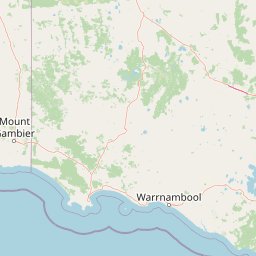
Map view of Hacks Lagoon Conservation Park

Use this park location map to pinpoint Hacks Lagoon Conservation Park in Australia, understand its exact geographic position, and read its mapped placement within the surrounding landscape more clearly.

Pigeon | © OpenStreetMap contributors

Location context for Hacks Lagoon Conservation Park

South Australia
Recorded earthquake history

Explore Historical Earthquake Records for Hacks Lagoon Conservation Park

Consult the MoriAtlas earthquake history catalogue for Hacks Lagoon Conservation Park to view recorded seismic events in the region. This data resource enables users to examine historical proximity, magnitude, and depth trends for events associated with this wetland conservation area.

Hacks Lagoon Conservation Park Earthquake History

Catalogued events

1 event

Strongest magnitude

Magnitude 3.4

Most recent event

Nov 8, 1989

This history includes earthquakes recorded inside the park or within 50 km of its borders

Park atlas

Compare nearby wetland reserves and protected landscapes across the Limestone Coast

Other Parks and Protected Areas Near Hacks Lagoon Conservation Park

Browsing nearby protected areas allows travelers to compare wetland habitats and regional reserves surrounding Hacks Lagoon Conservation Park. Extending the geographic review reveals connected conservation zones across the agricultural plains of South Australia.
National parkSouth Australia
6.9 km away#1 closest

Northeast

Naracoorte Caves National Park: Detailed Map and Protected Landscape Context in South Australia

Explore its unique protected geography and natural terrain.

Naracoorte Caves National Park represents a vital protected area within the diverse geography of South Australia. This entry provides an atlas-driven perspective, highlighting its identity as a national park, its mapped landscapes, and its regional significance. Engage with structured information detailing the park's protected status and geographic features, offering a clear view of its contribution to South Australia's natural heritage.

Area
6.6 km²
Established
2001
IUCN
II
Visitors
90.8K annual
Wildlife reserveSouth Australia
9.4 km away#2 closest

West

Big Heath Conservation Park: Mapping Protected Landscapes in South Australia

A strict nature reserve of woodland and wetland mosaics.

Big Heath Conservation Park represents a significant protected area in the Limestone Coast region of South Australia. The terrain is characterized by a gently undulating plain where subtle variations in elevation and soil composition create a distinct patchwork of eucalypt woodlands, sandy heath, and seasonal depressions linked to regional hydrological drainage systems.

Area
24.72 km²
Established
1964
IUCN
Ia
Relief
Lowland
Nature reserveSouth Australia
About 15 km away#3 closest

Southeast

Glen Roy Conservation Park: Geography and Protected Landscape Atlas

Nature reserve terrain in south-east South Australia

Glen Roy Conservation Park stands as a significant protected remnant in south-eastern South Australia, encompassing a diverse array of calcarenite dune ridges, bleached sand dunes, and seasonal interdunal swamps. The park area is managed for its ecological variety, featuring distinct vegetation associations ranging from brown stringybark open forest to river red gum woodland and closed heathland.

Area
5.44 km²
Established
1970
IUCN
III
Relief
Lowland
Nature reserveWattle Range
About 32 km away#4 closest

Southwest

Calectasia Conservation Park: Protected Area Mapping and Landscape Context in Wattle Range

Rare plant habitat and stranded dune ecosystems in South Australia

Calectasia Conservation Park serves as an important protected site within Wattle Range, preserving a delicate balance between seasonally inundated swampland and dry sandy-land woodland. This geographic overview examines the reserve's protected status, its history of habitat management, and the distinct physical terrain that supports a rare population of blue tinsel lily.

Area
0.14 km²
Established
1967
IUCN
IV
Relief
Lowland
Nature reserveSouth Australia
About 32 km away#5 closest

North

Grass Tree Conservation Park: A Protected Nature Reserve in South Australia

Geography and native woodland map exploration.

Grass Tree Conservation Park is a 16 hectare nature reserve in the Limestone Coast of South Australia, focused on the protection of iconic grass trees. The reserve captures a landscape of calcarenite dunes and diverse forest communities, including brown stringybark and pink gum. Through its protected status, it offers valuable insight into the native vegetation and sandy terrain typical of the West Naracoorte Range.

Area
0.16 km²
Established
1972
IUCN
III
Relief
Lowland
Nature reserveSouth Australia
37 km away#6 closest

Northwest

Fairview Conservation Park: Protected Nature Reserve and Limestone Coast Geography

Mapped wetlands, sandy ridges, and woodlands in southeastern South Australia

Explore the geographic framework of Fairview Conservation Park, a nature reserve in South Australia's Limestone Coast. The protected area features a unique intersection of semi-permanent lagoons, periodically inundated flats, and varied woodland vegetation including blue gum and manna gum, offering a clear window into the regional geological and ecological character of the area.

Area
13.94 km²
Established
1960
IUCN
Ia
Relief
Lowland
Nature reserveSouth Australia
About 50 km away#7 closest

Southwest

Furner Conservation Park Geography and Protected Woodland Atlas for South Australia

A study of forest remnants, sandy rises, and coastal dune topography

Furner Conservation Park preserves a significant mosaic of native woodlands within the Limestone Coast region. The terrain shifts between sandy rises and stony calcarenite ridges, supporting distinct forest communities that offer a vital look into the natural history and regional geography of South Australia.

Area
2.89 km²
Established
1973
IUCN
III
Relief
Upland
National parkAustralia
52 km away#8 closest

Northeast

Little Desert National Park: Victoria's Semi-Arid National Park and Protected Landscape

Explore mapped boundaries and unique mallee heathland ecosystems.

Delve into the protected landscape of Little Desert National Park, a significant national park covering over 1,300 square kilometers of Victoria's semi-arid western region. This area is characterized by its deep sandy soils, mallee heathlands, and diverse wildlife, including important populations of native birds. Understanding its geographic setting and mapped boundaries provides crucial insight into Australia's conservation efforts and the preservation of unique desert ecosystems.

Area
1,326.47 km²
Established
1988
IUCN
II
Visitors
50K annual

Common questions about visiting, size, designation, and location context for Hacks Lagoon Conservation Park

Hacks Lagoon Conservation Park FAQs for park facts, access, geography, and protected area context

Find quick answers about Hacks Lagoon Conservation Park, including protected-area facts, park geography, trail and visitor context, and how the park fits into its surrounding country and regional landscape.
MoriAtlas Explorer

Continue Your Protected Areas Search Across the Global Atlas

Deepen your exploration by continuing the structured search for national parks and protected areas worldwide. Utilize the comprehensive filtering capabilities to compare different conservation landscapes and refine your understanding of global park geography. Discover more about the distribution and characteristics of protected natural areas.

Global natural geography