Mori Atlas logo
Protected areaHakai Lúxvbálís Conservancy

A detailed look at the island chains, temperate rainforests, and marine foreshore ecosystems

Hakai Lúxvbálís Conservancy: Mapping the Coastal Wilderness of British Columbia Protected Lands

Hakai Lúxvbálís Conservancy represents a significant expanse of protected territory along the Central Coast of British Columbia. This coastal wilderness integrates rugged island landscapes, including Hunter, Goose, and Calvert islands, with essential marine foreshore habitats. Managed through a partnership that honors Heiltsuk Nation stewardship, the area remains a primary example of large scale ecological connectivity between terrestrial temperate rainforests and the Pacific shoreline.

coastal conservancyBritish ColumbiaCentral Coastisland wildernesstemperate rainforestmarine protected area

Hakai Lúxvbálís Conservancy

Protected area

Park overview

Structured park overview, official facts, and landscape profile for Hakai Lúxvbálís Conservancy

Hakai Lúxvbálís Conservancy park facts, protected area profile, and essential visitor context

Review the core facts for Hakai Lúxvbálís Conservancy, including designation, size, terrain, visitor scale, habitats, and operating context in one park-focused overview.

About Hakai Lúxvbálís Conservancy

Hakai Lúxvbálís Conservancy is a remote and expansive protected area on the British Columbia Central Coast, designed to conserve both terrestrial and marine ecosystems in an interconnected landscape. It lies within the Hecate Lowland ecosection, a coastal geographic zone characterized by a mixture of forested lowlands, inlets, and island archipelagos along the Pacific. Approximately 20 kilometres south of Bella Bella, the conservancy occupies a strategic position between larger island systems and the open waters of Hecate Strait.

The land base of the conservancy is spread across several notable coastal islands. Hunter Island forms a major part of the northern extent of the area, and Goose Island marks an additional northern feature. Toward the southern end of the conservancy, part of Calvert Island is included, creating a continuous protected corridor that links to the neighboring Calvert Island Conservancy. This arrangement effectively knits together a chain of protected landscapes along a significant stretch of coast.

In total, the conservancy spans 122,998 hectares, which is divided between roughly 51,914 hectares of upland terrain and approximately 69,137 hectares of foreshore marine environment. This balance distinguishes Hakai Lúxvbálís from purely terrestrial reserves, emphasizing the importance of protecting coastal waters, intertidal zones, and nearshore ecological processes in unison with the rainforest and island ecosystems onshore.

Governance of the conservancy is shared through a cooperative agreement between the Heiltsuk Nation, known in their language as the Haíłzaqv, and the Province of British Columbia. This arrangement acknowledges aboriginal rights while still supporting public conservation and recreation values. The result is a protected area that reflects both contemporary conservation science and the long-standing relationship between the Heiltsuk people and the Central Coast landscape.

Quick facts and research context for Hakai Lúxvbálís Conservancy

Hakai Lúxvbálís Conservancy is located in the Central Coast Regional District of British Columbia, Canada, near the Heiltsuk community of Bella Bella. It belongs to the Hecate Lowland ecosection and includes major coastal islands such as the southern part of Hunter Island, Goose Island, and part of Calvert Island.

The conservancy covers approximately 122,998 hectares in total, split between upland terrestrial areas and a substantial foreshore marine zone that protects adjacent ocean waters. It was established in 2008 under BC Parks and is cooperatively managed with the Heiltsuk Nation (Haíłzaqv).

Protection and recognition

Examine documented protection scope and official designation details for Hakai Lúxvbálís Conservancy

Hakai Lúxvbálís Conservancy Protection Status and Conservation Records

Comprehensive protected area records outline the mixed management scope and administrative framework established for Hakai Lúxvbálís Conservancy. Verified conservation data details formal protection status and international recognition criteria without additional assumptions.

Protection details

Protection scope
Mixed
Transboundary protection
No
Park context

Deeper park guide and search-rich context for Hakai Lúxvbálís Conservancy

Hakai Lúxvbálís Conservancy history, landscape, wildlife, and travel context

Explore Hakai Lúxvbálís Conservancy through its history, landscape character, ecosystems, wildlife, conservation priorities, cultural context, and seasonal travel timing in a structured park guide built for atlas discovery and search intent.

Why Hakai Lúxvbálís Conservancy stands out

Hakai Lúxvbálís Conservancy is especially known for its large, continuous coastal wilderness that links protected upland rainforest with extensive nearshore marine habitat on British Columbia's Central Coast. Its geography spans island chains and lowland mainland edge, giving the conservancy landscape-scale ecological significance rather than just a single scenic feature. The conservancy is also recognized for its co-management arrangement with the Heiltsuk Nation, integrating aboriginal rights and traditional stewardship into modern protected-area governance. Together, these qualities make it a flagship example of large, integrated land and sea protection in the Pacific Northwest.

Hakai Lúxvbálís Conservancy history and protected-area timeline

Hakai Lúxvbálís Conservancy was formally established in 2008 as part of British Columbia's expanding system of conservancies, a protected-area designation managed by BC Parks that emphasizes both ecological protection and opportunities for compatible recreation. Its creation occurred during a period when the province was actively increasing the representation of coastal and marine ecosystems within its network of protected lands.

A defining element of the conservancy's history is its governance model. Rather than being administered solely as a provincial reserve, it was created through a co-operative management agreement between the Heiltsuk Nation and the Government of British Columbia. This framework recognized the Heiltsuk's aboriginal rights and traditional connection to the land and sea in the region, ensuring that access and resources remain available to them while the area is also managed for conservation purposes.

The inclusion of land-and-sea parcels around Hunter Island, Goose Island, and Calvert Island reflects deliberate planning to extend protection across a continuous stretch of coastal geography rather than creating a series of isolated reserves. The conservancy has, since its inception, served as a bridge between ecological preservation and indigenous stewardship on the Central Coast.

Hakai Lúxvbálís Conservancy landscape and geographic character

The landscape of Hakai Lúxvbálís Conservancy is defined by the meeting of temperate rainforest and ocean along British Columbia's Central Coast. Set within the Hecate Lowland ecosection, the area features coastal lowland terrain interspersed with elevated island ridges, rugged shorelines, sheltered inlets, and exposed outer coast. The terrain is shaped by the persistent influence of the Pacific Ocean, with rocky headlands, forested valleys, and pocket beaches characteristic of the region.

Island scenery dominates much of the conservancy. Hunter Island provides extensive forested upland in the northern part of the protected area, while Goose Island adds additional coastal landform and habitat variety nearby. Toward the south, part of Calvert Island contributes more shoreline, lowland forest, and connections to the broader Calvert Island landscape. These island environments together create a visually compelling seascape of forested hills rising from often calm and sheltered marine waters.

Because the conservancy includes a substantial foreshore area, its landscape character is inseparable from the surrounding seascape. Intertidal zones, nearshore channels, bays, and small islands form part of the visual and ecological setting. The combination of marine and terrestrial scenery gives Hakai Lúxvbálís a strong sense of remote Pacific coastal wilderness.

Hakai Lúxvbálís Conservancy ecosystems, habitats, and plant life

The ecological profile of Hakai Lúxvbálís Conservancy is shaped by the temperate rainforest and marine ecosystems typical of British Columbia's Central Coast. On land, the area supports moist coastal forests, coastal lowland vegetation communities, and island-specific habitats influenced by salt spray, wind exposure, and soil conditions. These forests form part of the broader Hecate Lowland ecological context and contribute to regional biodiversity by sustaining a continuum of native plant communities away from more developed coastlines.

The marine environment is equally important, with foreshore waters, intertidal zones, and nearshore subtidal habitats forming an essential part of the conservancy's natural value. The mix of sheltered channels and more exposed outer coast conditions supports a wide range of marine life and ecological processes, including coastal nutrient cycling that supports both marine and terrestrial food webs.

Together, the terrestrial and marine habitats make Hakai Lúxvbálís a strong example of integrated coastal biodiversity conservation in British Columbia, where protecting land alone would only address part of a functioning coastal ecosystem.

Hakai Lúxvbálís Conservancy wildlife and species highlights

The wildlife profile of Hakai Lúxvbálís Conservancy reflects the richness of British Columbia's Central Coast, where marine and terrestrial fauna are closely interconnected. The surrounding marine environment supports species typical of the region's productive nearshore waters, including forage fish, marine mammals such as seals and potentially larger cetaceans, and seabirds associated with this stretch of the Pacific coast.

On land, the temperate rainforest and island habitats provide cover and forage for wildlife typical of coastal British Columbia, including black bears, wolves, deer, and small forest-dwelling mammals. The mosaic of shoreline, forest, and marine environments also makes the conservancy important for a variety of birdlife, from nearshore seabirds and waterfowl to forest-interior songbirds and raptors that use the islands and adjacent mainland coast.

Hakai Lúxvbálís Conservancy conservation status and protection priorities

Hakai Lúxvbálís Conservancy plays a significant conservation role on British Columbia's Central Coast by safeguarding a large, interconnected land-and-sea protected area within the Hecate Lowland ecosection. Its size and ecological diversity make it an important contributor to maintaining habitat connectivity among coastal island systems, including the adjacent Calvert Island Conservancy and protected areas farther north.

The inclusion of more than 69,000 hectares of foreshore within the conservancy reflects an emphasis on marine protection alongside terrestrial conservation. This is increasingly important in Pacific coastal management, where nearshore habitats, intertidal zones, and coastal waters support a wide range of ecological processes and species.

Another key dimension of the conservancy's conservation significance is its cooperative management framework with the Heiltsuk Nation. By aligning protected-area status with indigenous stewardship and aboriginal rights, the conservancy represents a conservation model that integrates ecological protection with the longstanding cultural relationship between the Haíłzaqv and their traditional territory.

Hakai Lúxvbálís Conservancy cultural meaning and human context

Hakai Lúxvbálís Conservancy is part of the traditional territory of the Heiltsuk Nation, known in their language as the Haíłzaqv, whose connection to the Central Coast of British Columbia extends back many generations. The conservancy's co-operative management agreement reflects this relationship, recognizing aboriginal rights and ensuring continued access and use of resources for the Heiltsuk people.

The nearby community of Bella Bella, the principal Heiltsuk settlement, anchors the cultural context of the region, even though the conservancy itself lies outside the immediate community. Coastal indigenous stewardship in this region has long emphasized the integrated management of land and sea, a perspective that aligns naturally with the conservancy's combined terrestrial and marine protected-area status.

Rather than being a stand-alone provincial reserve, Hakai Lúxvbálís Conservancy serves as an example of a protected area that meaningfully integrates indigenous governance, traditional land-sea relationships, and contemporary conservation practice.

Top sights and standout views in Hakai Lúxvbálís Conservancy

Among the standout qualities of Hakai Lúxvbálís Conservancy is its remarkable scale for a coastal British Columbia protected area, including both more than 51,000 hectares of upland and a substantial foreshore area that extends protection into the marine environment. Few nearby reserves combine terrestrial and marine protection at this magnitude within a single designation.

The geography of the conservancy is equally notable, linking major coastal islands such as Hunter Island, Goose Island, and part of Calvert Island into a continuous corridor of protection along the Central Coast. This ecological connectivity is reinforced by the adjacent Calvert Island Conservancy, amplifying the conservancy's landscape-level importance.

Finally, the cooperative governance structure with the Heiltsuk Nation elevates the conservancy as a model of indigenous partnership in modern protected-area management, balancing conservation, recreation, and aboriginal rights in one framework.

Best time to visit Hakai Lúxvbálís Conservancy

Because Hakai Lúxvbálís Conservancy is located along the Central Coast of British Columbia, the character of a visit is strongly shaped by the region's mild, wet, marine climate. Summers typically offer the most favorable conditions for coastal travel and recreation, with longer daylight hours, generally calmer sea conditions, and more reliable weather windows for boat-based access to the islands. This period also tends to be more productive for viewing coastal wildlife and exploring intertidal areas at low tide.

Shoulder seasons can provide quieter conditions and excellent atmospheric scenery, but increased rainfall, shorter days, and rougher marine conditions can make travel more demanding. Winters are characterized by heavy precipitation, storms, and limited daylight, which make the area much less suited to casual or extended outdoor visits.

Seasonal timing may also influence wildlife observation; seabird activity, marine mammal presence, and the rhythms of the coastal forest all vary across the year, giving different periods subtly different ecological emphases rather than a single peak season.
Monthly climate preview

Long-term temperature ranges and monthly precipitation patterns sampled at a representative coordinate

Hakai Lúxvbálís Conservancy Climate Normals and Annual Weather Rhythm

Measured NASA Power climatology data spanning 1991 through 2020 outlines the multi-year average temperature progression and daily precipitation rates across twelve distinct intervals. Analyzing the complete monthly profile provides deeper quantitative insight into the representative coordinate data recorded for this protected area.
Annual mean8 °C
3 °C15 °C
Jan
Feb
Mar
Apr
May10°
Jun12°
Jul14°
Aug15°
Sep13°
Oct
Nov
Dec
Warmest month
August

14.8 °C

Coolest month
January

3.2 °C

Wettest month
November

11.1 mm/day

Driest month
July

3.5 mm/day

Park location guide

Geography guide, regional context, and park location map for Hakai Lúxvbálís Conservancy

Hakai Lúxvbálís Conservancy park geography, regions, and map view in Canada

Understand where Hakai Lúxvbálís Conservancy sits in Canada through a broader geographic reading of the surrounding landscape, nearby location context, and its mapped position within the national park landscape.

How Hakai Lúxvbálís Conservancy fits into Canada

Canada is a federal parliamentary constitutional monarchy spanning North America from the Atlantic to the Pacific and Arctic Oceans. With a population of over 41 million, it is officially bilingual in English and French at the federal level. The country gained independence from the United Kingdom through a gradual process culminating in 1982.

Wider geography shaping Hakai Lúxvbálís Conservancy in Canada

Canada occupies the northern portion of North America, sharing its longest international border with the United States. The country extends from the Atlantic Ocean to the Pacific Ocean and northward into the Arctic Ocean, giving it the longest coastline of any nation.

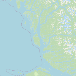
Map view of Hakai Lúxvbálís Conservancy

Use this park location map to pinpoint Hakai Lúxvbálís Conservancy in Canada, understand its exact geographic position, and read its mapped placement within the surrounding landscape more clearly.

Pigeon | © OpenStreetMap contributors

Location context for Hakai Lúxvbálís Conservancy

British Columbia
Park atlas

Compare adjacent island wilderness reserves and regional marine protected landscapes across the Central Coast.

Explore Parks Near Hakai Lúxvbálís Conservancy and Surrounding Coastal Protected Areas

Visitors browsing Hakai Lúxvbálís Conservancy can examine neighboring coastal reserves, temperate rainforests, and marine protected areas. Comparing these surrounding regional locations reveals broader ecological patterns and landscape connectivity across the Pacific coast.
A soft, light watercolor painting of a winding river flowing through a forested valley with distant, muted mountain ranges under a pale sky.
Protected areaBritish Columbia
About 105 km away#1 closest

North

Kitlope Heritage Conservancy: Coastal Temperate Rainforest and Mountain Watersheds

A vast protected area in the Kitimat-Stikine region of British Columbia

Spanning from the Gardner Canal to glaciated inland summits, the Kitlope Heritage Conservancy protects an entire, undisturbed watershed. It is defined by its transition from saltwater fjords through ancient, salmon-bearing river valleys to high granite peaks, acting as a vital benchmark for coastal ecosystem integrity in the Pacific Northwest.

Area
3,220.2 km²
Established
1996
IUCN
Ib
Relief
Mountain
A soft watercolor painting of a serene coastal landscape with distant green hills, calm water, and foreground grasses, rendered in a minimalist style on a white background.
Protected areaBritish Columbia
About 115 km away#2 closest

North

Fiordland Conservancy Protected Area: Mapping British Columbia's Glacial Fjord Coastline

A remote coastal wilderness in the Kitimat Ranges

Fiordland Conservancy guards an important stretch of the central British Columbia coast, where the steep, forested slopes of the Kitimat Ranges meet deep marine inlets. Known for its role in protecting the province's fjord environments, the area consists of an undeveloped, roadless landscape accessible only by sea, showcasing a dramatic transition from tidal shorelines to high mountain peaks.

Area
768.25 km²
Established
1987
IUCN
Ib
Relief
Mountain
State or regional parkBritish Columbia
About 137 km away#3 closest

South

Raft Cove Provincial Park: Coastal Wilderness and Protected Landscapes in British Columbia

Rugged shorelines and temperate rainforest terrain

Raft Cove Provincial Park protects a wild segment of Vancouver Island's northwestern coast. The region features a crescent-shaped sandy beach, significant river estuaries, and dense western hemlock forests. This protected area offers insight into the isolated coastal geography and the raw Pacific marine influences that shape the local wilderness terrain.

Area
7.87 km²
Established
1990
IUCN
II
Relief
Lowland
State or regional parkBritish Columbia
About 150 km away#4 closest

South

Quatsino Provincial Park: An Atlas Overview of Protected Coastal Lands in British Columbia

Mapping Old-Growth Rainforest and Sheltered Marine Estuaries

Quatsino Provincial Park offers a unique geographic profile, serving as a protected sanctuary for coastal temperate wildlife along the rugged northern edge of Vancouver Island. The area bridges marine, freshwater, and forest ecosystems, centering on the sheltered waters of Koprino Harbour and the surrounding ancient stands of old-growth trees. This atlas entry details the physical landscape, boundaries, and regional context of this isolated coastal haven.

Area
6.54 km²
Established
1995
IUCN
II
Relief
Lowland
National parkHaida Gwaii
About 192 km away#5 closest

West

Gwaii Haanas National Park Reserve and Haida Heritage Site: National Park Protected Area

Explore the mapped geography and landscape context of Haida Gwaii.

Gwaii Haanas National Park Reserve and Haida Heritage Site offers a clear view of a protected national park's landscape and geographic positioning. This page provides detailed information on its specific boundaries and its location within the Haida Gwaii region, serving as a key point for understanding protected land distribution and regional geography through an atlas lens.

Area
1,470 km²
Established
1988
IUCN
II
Relief
Mountain
Protected areaBritish Columbia
About 225 km away#6 closest

Southeast

Forward Harbour/Yexeweyem Conservancy Protected Area Geography and Coastal Atlas

Coastal wilderness protected landscape on Vancouver Island.

Forward Harbour/Yexeweyem Conservancy preserves a distinct segment of British Columbia coastline. Featuring the Thynne Peninsula and sheltered sections of Bassborough Bay, this remote protected area emphasizes the preservation of marine inlets and salmon habitats within a traditional Indigenous landscape.

Area
3.06 km²
Established
2007
Access
Remote access
Scope
Terrestrial
A horizontal watercolor painting showing a calm inlet surrounded by forested hills and distant mountains.
State or regional parkBritish Columbia
About 232 km away#7 closest

Northwest

Klewnuggit Inlet Marine Provincial Park: Regional Geography and Protected Area Mapping

Coastal inlet, freshwater lakes, and northern forest ecosystems.

Klewnuggit Inlet Marine Provincial Park showcases the dramatic meeting of mountain, forest, and sea. Spanning from the sheltered waters of the Grenville Channel to inland freshwater systems, the park offers a detailed study of northern coastal geography, fjord-like marine channels, and diverse bird and marine wildlife habitats.

Area
18 km²
Established
1993
IUCN
II
Relief
Mixed relief
Protected areaStrathcona Regional District
About 238 km away#8 closest

Southeast

Phillips Estuary/ʔNacinuxʷ Conservancy: Geographic Mapping and Protected Area Context

Coastal river valley and estuarine conservation on Vancouver Island

Delve into the geography of the Phillips Estuary/ʔNacinuxʷ Conservancy, where riverine systems meet the marine coastline of the Strathcona Regional District. This protected area represents an essential transition zone, featuring forested uplands and tidal flats that form a continuous conservation landscape. Its mapping reveals the interconnected nature of the Phillips River valley, highlighting the ecological value of these protected lands for coastal researchers and geography enthusiasts.

Area
14.61 km²
Established
2007
IUCN
II

Common questions about visiting, size, designation, and location context for Hakai Lúxvbálís Conservancy

Hakai Lúxvbálís Conservancy FAQs for park facts, access, geography, and protected area context

Find quick answers about Hakai Lúxvbálís Conservancy, including protected-area facts, park geography, trail and visitor context, and how the park fits into its surrounding country and regional landscape.
MoriAtlas Explorer

Continue Your Protected Areas Search Across the Global Atlas

Deepen your exploration by continuing the structured search for national parks and protected areas worldwide. Utilize the comprehensive filtering capabilities to compare different conservation landscapes and refine your understanding of global park geography. Discover more about the distribution and characteristics of protected natural areas.

Global natural geography