
Mori Atlas logo
Protected landscapeHartwald mit Umgebung

A study of relief inversion topography, orchard meadow networks, and historic forested hill landscapes.

Hartwald mit Umgebung Protected Landscape: Exploring the Geological and Natural Terrain in Baden-Württemberg, Germany

(Landschaftsschutzgebiet Hartwald und Umgebung)

Hartwald mit Umgebung encompasses a 202.5-hectare protected landscape centered on a distinct 326-meter forested hill that rises above the Neckar basin. This site offers significant insight into geological relief inversion, where an erosion-resistant sandstone cap preserves a landmark elevation amidst flat agricultural plains. The mapped area integrates diverse terrain features, including traditional orchard meadows, stream valleys, and ancient burial sites, providing a snapshot of the cultural and natural geography within the Rems-Murr district.

landscape protection areaIUCN Category Vforested hillStreuobstwiesenorchard meadowsmixed forest
A flat, stylized digital illustration of a landscape with rows of trees, orchards, and rolling hills under a soft sky.

Hartwald mit Umgebung

Protected landscape

Park overview

Structured park overview, official facts, and landscape profile for Hartwald mit Umgebung

Hartwald mit Umgebung park facts, protected area profile, and essential visitor context

Review the core facts for Hartwald mit Umgebung, including designation, size, terrain, visitor scale, habitats, and operating context in one park-focused overview.

About Hartwald mit Umgebung

Hartwald mit Umgebung is a Baden-Württemberg landscape protection area that combines a small forested hill with the orchard and meadow landscape surrounding it. It lies west of the Rems valley between Fellbach and Waiblingen, close to the boundary with the Ludwigsburg district near Remseck am Neckar, and sits within the natural region of the Neckar basin, more specifically the Schmidener Feld subregion.

Approximately three quarters of the protected area lies within the Oeffingen district of Fellbach, while the remainder is part of Hegnach, a district of Waiblingen. The protected area merges naturally into the wider Rems valley landscape, and the boundary only becomes obvious when the adjacent lower Rems valley protection area ends. Visitors experience the Hartwald as an island of woodland and orchard meadows set within an agricultural plain, traversed by small valleys and bordered by larger river landscapes.

Although the protected area is not large, it holds notable ecological and cultural value. The mixed forests on the hill contain a remarkable diversity of species for such a small area, the surrounding traditional Streuobstwiesen (extensively managed fruit meadows) represent a centuries-old form of land use, and Iron Age burial mounds on the Oeffingen side reflect a much older human presence in the landscape. The site also carries a recognizable local identity, including a 30-meter-high water tower on the hilltop that has stood there since 1963 and visible place-name references like Obere Hart, Untere Hart, and Mittlere Hart.

Quick facts and research context for Hartwald mit Umgebung

Hartwald mit Umgebung is a 202.5-hectare landscape protection area (Landschaftsschutzgebiet) in the state of Baden-Württemberg, located on the territory of Fellbach and Waiblingen in the Rems-Murr district.

Its protected-area reference number is 1.19.013, it was established on November 4, 1968, and is managed by the Regierungspräsidium Stuttgart. The core of the area is the Hartwald, a forested hill roughly 326 meters above sea level that rises above the loess plain between Fellbach, Waiblingen, and Remseck am Neckar and is classified as an IUCN Category V protected landscape.

Protection and recognition

Examine verified conservation data and official protected area records.

Hartwald mit Umgebung Protection Status and Designated Area Records

Examine the documented protection status and designated area records established for Hartwald mit Umgebung. Review the verified database entries providing structured international recognition metrics and administrative context.

Protection details

WDPA ID
321400
Park context

Deeper park guide and search-rich context for Hartwald mit Umgebung

Hartwald mit Umgebung history, landscape, wildlife, and travel context

Explore Hartwald mit Umgebung through its history, landscape character, ecosystems, wildlife, conservation priorities, cultural context, and seasonal travel timing in a structured park guide built for atlas discovery and search intent.

Why Hartwald mit Umgebung stands out

Hartwald mit Umgebung is best known for the Hartwald hill itself, a small but prominent wooded summit that breaks the otherwise flat loess plain of the Schmidener Feld subregion of the Neckar basin. The hill was geologically shaped by relief inversion, where an originally sunken fault zone left behind an erosion-resistant sandstone cap that became today's highest point in the immediate area. Around the forested summit, the protected landscape preserves a traditional mosaic of orchards, meadows, small valleys, and archaeological sites, making it a characteristic example of a culturally shaped low mountain landscape in the Stuttgart region.
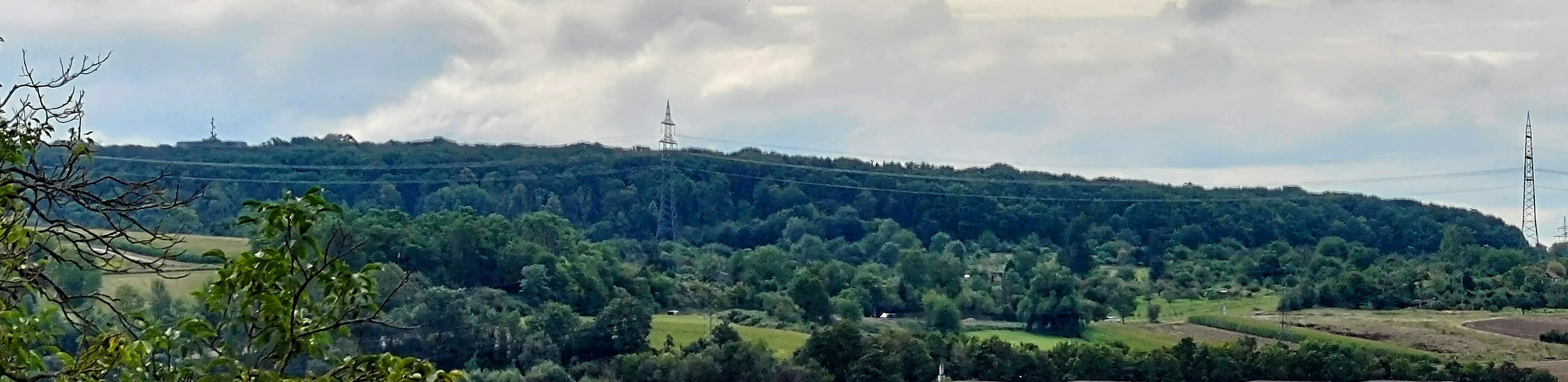
A panoramic view of a dense, forested hill under a cloudy sky, with electricity pylons visible along the ridgeline and rural fields in the foreground.
A wide view of the Hartwald forest as seen from the direction of Aldingen.

Hartwald mit Umgebung history and protected-area timeline

Hartwald mit Umgebung was formally placed under landscape protection on November 4, 1968, when the Baden-Württemberg authorities designated the hill and its surrounding agricultural landscape as a Landschaftsschutzgebiet under reference number 1.19.013. Its designation reflected both the scenic prominence of the Hartwald hill rising above the Neckar basin plain and the ecological value of its mixed forests, traditional orchard meadows, and small stream valleys.

The hill's human history runs much deeper. Place names that repeat the word Hart in the surrounding fields, including Obere Hart and Untere Hart near Oeffingen, Mittlere Hart near Hegnach, and Hartäcker near Neckarrems, indicate that the area has been recognized as a distinctive wooded feature for centuries. The presence of Iron Age burial mounds in the western, Oeffingen portion of the protected area confirms that the landscape has been in use since prehistoric times.

Modern interventions have also shaped the site: a 30-meter-high water tower has stood on the summit of the Hartwald since 1963, making the hill a locally recognizable landmark. Today the area continues to be administered by the Regierungspräsidium Stuttgart and operates both as a protected natural landscape and as a nearby recreation space for the surrounding towns.

Hartwald mit Umgebung landscape and geographic character

The defining physical feature of Hartwald mit Umgebung is the Hartwald itself: a roughly 326-meter-high forested hill that rises from the otherwise flat loess plain of the Schmidener Feld. Geologically, the hill is a product of relief inversion. The Hartwald Fault, a roughly one-kilometer-wide graben formed during the Tertiary period and running from Waiblingen to Aldingen, originally dropped a section of terrain below its surroundings. The upper part of this subsided block, made of erosion-resistant Schilfsandstein of the Stuttgart Formation, was preserved as erosion removed the surrounding softer material, leaving behind what is now the highest point between Fellbach, Waiblingen, and Remseck am Neckar.

Surrounding the wooded summit, the protected area's landscape is dominated by extensive Streuobstwiesen, traditional orchards with scattered fruit trees, interspersed with small fields and meadows. To the north, a forested depression separates the Hartwald from another wooded ridge between the Rems and Neckar rivers. To the east, the area transitions smoothly into the broader Rems valley, while to the south the Ruckgraben stream marks the boundary between the protected area and the core of the Schmidener Feld. On the western, Oeffingen side, the intermittently flowing Rötensteingraben stream rises in the Hartwald and runs westward toward Aldingen before reaching the Neckar.

A 30-meter-high water tower has stood on the summit of the Hartwald since 1963, providing a visible landmark above the otherwise gently rolling agricultural landscape.

Hartwald mit Umgebung ecosystems, habitats, and plant life

The protected area preserves a striking ecological transition between forest, orchard, and open farmland within a very compact footprint. The mixed forests of the Hartwald hill are notable for their species diversity, unusual for such a small area, supporting a range of woodland habitats on the slope and summit.

Around the forest, the extensive Streuobstwiesen form a traditionally managed semi-open landscape. These orchards blend open grasslands with scattered fruit trees, hedges, and small watercourses, creating transitional habitats that support insects, birds, and small mammals. The Ruckgraben and Rötensteingraben streams, even where they flow only intermittently, contribute wet microhabitats along their courses and connect the protected area ecologically to the broader Rems and Neckar valleys.

Because the protected area overlaps with the Unteres Remstal bird protection area, it also carries regional importance for birds associated with the Rems valley landscape, including species that move between woodland, orchard, and riverine habitats.

Hartwald mit Umgebung wildlife and species highlights

Hartwald mit Umgebung is not primarily known as a wildlife destination, but the diversity of its habitats supports a richer fauna than its small size might suggest. The mixed forest on the Hartwald hill hosts typical woodland birdlife and small mammal communities, while the surrounding Streuobstwiesen provide important foraging and nesting habitat for orchard-associated species.

The Rems valley side of the protected area falls within the Unteres Remstal bird protection area, which gives the site additional relevance for bird conservation at the regional scale. The combination of forest, orchard, meadow, and stream habitats in close proximity supports a varied insect and bird community throughout the year.

Hartwald mit Umgebung conservation status and protection priorities

The Hartwald mit Umgebung was established as a Landschaftsschutzgebiet on November 4, 1968, to protect the wooded hill and the surrounding cultural landscape from being lost to development or land-use change. Its protected status covers approximately 202.5 hectares under reference number 1.19.013 and is classified in the IUCN system as a Category V Protected Landscape/Seascape.

From a conservation perspective, the area's main value is the preservation of a mixed forest with notably high species diversity on a small hill, together with the protection of an extensive, traditionally managed Streuobstwiesen landscape. These orchard meadows are themselves a cultural-ecological asset, supporting biodiversity while maintaining a centuries-old form of land use.

The protected area directly adjoins the larger Unteres Remstal mit Randgebieten landscape protection area and overlaps with the Unteres Remstal bird protection area, integrating it into a continuous network of protected landscapes along the lower Rems valley. The site is administered by the Regierungspräsidium Stuttgart.

Hartwald mit Umgebung cultural meaning and human context

The Hartwald and its surroundings carry a strong sense of local cultural identity. The repeated use of the word Hart in nearby place names, including Obere Hart and Untere Hart near Oeffingen, Mittlere Hart near Hegnach, and Hartäcker near Neckarrems, reflects how locals have long perceived the wooded hill as a distinctive landmark in the agricultural plain.

The Streuobstwiesen that surround the Hartwald are themselves a hallmark of the cultural landscape of Baden-Württemberg, representing a traditional form of fruit cultivation and meadow use that has shaped rural life for generations. Iron Age burial mounds located in the western, Oeffingen portion of the protected area add a deeper prehistoric dimension to the cultural profile of the site.

The 30-meter-high water tower that has stood on the summit of the Hartwald since 1963 has become a modern visual landmark, reinforcing the hill's role as a point of reference for the surrounding communities.

Top sights and standout views in Hartwald mit Umgebung

Hartwald mit Umgebung combines a compact forested hill, traditional orchard meadows, and small stream valleys in a single protected area of about 202.5 hectares, making it a representative example of a small, multifaceted Baden-Württemberg landscape protection area.

Its geological origin through relief inversion, the long human history reflected in Iron Age burial mounds and centuries-old place names, and its integration into a wider network of protected areas along the Rems valley together make it a site where natural and cultural landscape values reinforce each other.

Best time to visit Hartwald mit Umgebung

Hartwald mit Umgebung can be visited throughout the year, but spring is particularly rewarding when the surrounding Streuobstwiesen come into blossom and orchards fill the lower slopes with color. Summer offers shaded walking in the mixed forest of the Hartwald hill and views across the Neckar basin from the summit near the water tower.

Autumn brings harvest activity in the orchards and warm color in the deciduous forest, while winter, when leaves have fallen, opens up broader vistas from the hilltop across the flat agricultural plain toward the Rems and Neckar valleys.

Monthly climate preview

Long-term representative monthly temperature and precipitation data for Baden-Württemberg

Hartwald mit Umgebung Climate Normals and Annual Temperature Rhythm

Historical measurements from 1991 to 2000 outline the recorded temperature ranges and precipitation rates across twelve distinct months at a representative point in Hartwald mit Umgebung. Analyzing the complete monthly climate profile reveals specific long-term averages for daily minimum and maximum temperatures alongside precipitation patterns.
Annual mean9 °C
0 °C20 °C
Jan
Feb
Mar
Apr
May13°
Jun17°
Jul20°
Aug20°
Sep15°
Oct10°
Nov
Dec
Warmest month
July

19.6 °C

Coolest month
January

-0.2 °C

Wettest month
July

2.7 mm/day

Driest month
April

1.6 mm/day

Park location guide

Geography guide, regional context, and park location map for Hartwald mit Umgebung

Hartwald mit Umgebung park geography, regions, and map view in Germany

Understand where Hartwald mit Umgebung sits in Germany through a broader geographic reading of the surrounding landscape, nearby location context, and its mapped position within the national park landscape.

How Hartwald mit Umgebung fits into Germany

Germany is a federal republic in Western and Central Europe with a population of over 83 million across sixteen constituent states. It is Europe's largest economy by nominal GDP and a major global exporter and importer. The capital is Berlin, and the country borders Denmark, Poland, Czech Republic, Austria, Switzerland, France, Luxembourg, Belgium, and the Netherlands.

Wider geography shaping Hartwald mit Umgebung in Germany

Germany is located in Western and Central Europe, spanning 357,022 km². It borders Denmark to the north, Poland and the Czech Republic to the east, Austria and Switzerland to the south, and France, Luxembourg, Belgium, and the Netherlands to the west. The country has coastlines on the Baltic Sea and North Sea to the north, with the Alps located in the southern region.

Map view of Hartwald mit Umgebung

Use this park location map to pinpoint Hartwald mit Umgebung in Germany, understand its exact geographic position, and read its mapped placement within the surrounding landscape more clearly.

Pigeon | © OpenStreetMap contributors

Location context for Hartwald mit Umgebung

Baden-Württemberg

Visualizing the wooded hill, orchards, and protected terrain of Baden-Württemberg

Hartwald mit Umgebung Photos and Landscape Scenery

Photographic records capture the forested summit, traditional orchard meadows, and varied topography defining Hartwald mit Umgebung. Visual exploration reveals the geological relief inversion and protected landscape character spanning the Neckar basin.

A panoramic view of a dense, forested hill under a cloudy sky, with electricity pylons visible along the ridgeline and rural fields in the foreground.

A view of a grassy meadow with scattered fruit trees leading toward a dense line of forest under a cloudy sky.

Park atlas

Discover related regional landscapes and connected nature reserves across the Neckar basin.

Explore Parks Near Hartwald mit Umgebung and Surrounding Protected Areas

Continue browsing parks near Hartwald mit Umgebung to compare adjacent wooded hills, river valleys, and traditional orchard meadows. Expanding the search across the surrounding region reveals deeper geographical patterns among local protected landscapes.
Protected landscapeBaden-Württemberg
About 2.7 km away#1 closest

East

Unteres Remstal mit Randgebieten Protected Landscape and Regional Geographic Map

Mapping the cultural landscapes of Baden-Württemberg

Unteres Remstal mit Randgebieten represents a key protected landscape in Baden-Württemberg, encompassing the lower Rems river valley. This area preserves a rich mosaic of traditional orchard meadows, scrubby wastelands, and transitional slope reliefs that connect the valley floor to the rising Gäu plateau, forming a vital buffer for regional habitat connectivity.

Area
2.5 km²
Established
1987
IUCN
V
Relief
Lowland
A soft watercolor painting showing a pale river curving through green hills and vegetation.
Protected landscapeBaden-Württemberg
About 4.8 km away#2 closest

North

Neckartal zwischen den Neckarbrücken von Hochberg und Neckarweihingen Protected Landscape Overview

A detailed geographic look at the Neckar river valley and its surrounding terrain.

Analyze the protected landscape boundaries of the Neckar valley between Hochberg and Neckarweihingen. This area features a complex mosaic of renaturalized river floodplains, traditional terraced vineyards with stone walls, and wooded edge habitats in the Ludwigsburg district of Baden-Württemberg.

Area
3.803 km²
Established
1988
IUCN
V
Relief
Lowland
Protected landscapeBaden-Württemberg
About 5.1 km away#3 closest

Southwest

Zuckerberg-Muckensturm Protected Landscape: Geography and Cultural Viticulture Heritage

Exploring the Neckar valley slopes in Baden-Württemberg

Zuckerberg-Muckensturm represents a vital cultural landscape on the outskirts of Stuttgart, characterized by its historical vine-growing terraces and exposed Muschelkalk limestone cliffs. The area serves as a significant case for studying regional earth history and the interplay between urban-adjacent land use and natural geological monuments within the Neckar river valley.

Area
0.505 km²
Established
1987
IUCN
V
A horizontal watercolor painting of layered, soft green and yellow hills, stylized and minimalist.
Protected landscapeBaden-Wuerttemberg
About 12 km away#4 closest

Northwest

Neckartal zwischen Benningen und Großingersheim mit angrenzenden Gebieten Geography and Maps

A preserved Swabian river valley and vineyard landscape

This protected landscape in Baden-Wuerttemberg encompasses the scenic Neckar river bend. The area combines traditional vineyard terraces, riparian corridors, and gentle valley topography to maintain a functional cultural landscape within the Ludwigsburg district.

Area
4.1 km²
Established
1985
IUCN
V
Relief
Lowland
Protected landscapeBaden-Württemberg
About 12 km away#5 closest

East

Zipfelbachtal, Korber Kopf, Buocher Höhe, Remstalhänge, Ramsbachtal und Grafenberg Protected Landscape Map

Mapping the Keuper cultural landscape of Baden-Württemberg

Study the intricate topography and land use patterns of this expansive protected area in the Rems-Murr-Kreis. The region preserves a variety of habitats, including vineyard slopes, traditional Streuobst orchards, and forested ravines, providing a clear window into the natural and agricultural heritage of the eastern Stuttgart region.

Area
20.856 km²
Established
1968
IUCN
V
Relief
Upland
Protected areaBaden-Württemberg
About 14 km away#6 closest

West

Penal Substitution: Protected Area Mapping and Regional Geography in Baden-Württemberg

Cultural landscape and habitat mosaic overview

Penal Substitution represents a preserved cultural landscape in the German state of Baden-Württemberg, featuring a structured mix of orchard meadows, farmland, and riparian habitats. This area serves as a critical regional green link, where mapped boundaries reveal a complex interplay of agricultural history and active environmental conservation just outside the urban core.

Area
2.586 km²
Established
2004
Relief
Upland
Climate
Temperate
Protected landscapeBaden-Württemberg
About 18 km away#7 closest

South

Unteres Körschtal Protected Landscape: Geography and Mapped Boundaries in Baden-Württemberg

An ecological green corridor within the Swabian Keuper-Lias landscape

Unteres Körschtal protects the natural valley floor and adjacent slopes of the lower Körsch river. This landscape conservation area provides essential habitat and recreational space between the Filder plateau and the Neckar valley, standing as a primary example of regional geography in Germany.

Area
4.729 km²
Established
1978
IUCN
V
Protected landscapeBaden-Württemberg
About 18 km away#8 closest

West

Wartbiegel - Katharinenlinde und Umgebung: Mapped Protected Landscape and Regional Geography

Traditional orchard mosaic in the Neckar basin, Germany

Discover the geographic structure of Wartbiegel - Katharinenlinde und Umgebung. This protected landscape preserves a unique relief of slopes and agricultural patterns in Baden-Württemberg. The area functions as a vital example of traditional land-use conservation, combining local ecological value with a textured rural landscape near Schwieberdingen.

Area
0.421 km²
Established
1987
IUCN
V
Relief
Upland

Common questions about visiting, size, designation, and location context for Hartwald mit Umgebung

Hartwald mit Umgebung FAQs for park facts, access, geography, and protected area context

Find quick answers about Hartwald mit Umgebung, including protected-area facts, park geography, trail and visitor context, and how the park fits into its surrounding country and regional landscape.
MoriAtlas Explorer

Continue Your Protected Areas Search Across the Global Atlas

Deepen your exploration by continuing the structured search for national parks and protected areas worldwide. Utilize the comprehensive filtering capabilities to compare different conservation landscapes and refine your understanding of global park geography. Discover more about the distribution and characteristics of protected natural areas.

Global natural geography