

Mori Atlas logo
State or regional parkHáthayim Marine Provincial Park

A marine-focused provincial park defining the unique shoreline geography of northern Cortes Island.

Háthayim Marine Provincial Park: Coastal Protected Landscapes in the Discovery Islands

Located on the northern end of Cortes Island, Háthayim Marine Provincial Park protects a complex marine environment where sheltered inlets meet the Pacific Northwest coastline. This protected area centers on the waters of Von Donop Inlet, preserving critical intertidal zones and coastal forest fringes within the Discovery Islands archipelago. Its geography captures the essential transition between the open waters of the Salish Sea and the protected interior channels characteristic of the British Columbia coastline.

marine parkcoastal landscapeDiscovery IslandsCortes IslandBritish Columbiainside passage

Háthayim Marine Provincial Park

State or regional park

Park overview

Structured park overview, official facts, and landscape profile for Háthayim Marine Provincial Park

Háthayim Marine Provincial Park park facts, protected area profile, and essential visitor context

Review the core facts for Háthayim Marine Provincial Park, including designation, size, terrain, visitor scale, habitats, and operating context in one park-focused overview.

About Háthayim Marine Provincial Park

Háthayim Marine Provincial Park sits within the Discovery Islands, a chain of islands, channels, and passages that lie between the northeast coast of Vancouver Island and the British Columbia mainland. More specifically, the park is situated on the northern end of Cortes Island, an island known for its mix of forested interior and varied, fjord-like coastline. The protected area surrounds Von Donop Inlet, a marine channel that drains northwest toward Sutil Channel, linking the sheltered waters of Cortes Island to the broader network of inside-passage waterways.

As a marine-focused park, its value lies primarily in the preservation of coastal and marine ecosystems rather than inland mountain or forest scenery. The protected waters and shorelines represent the kinds of habitats that define the inside passage of the Pacific Northwest: quiet inlets fringed by old-growth and second-growth coastal forest, tidal environments shaped by strong Pacific currents, and an interconnected system of channels that link numerous islands and coastal communities. The position of the park at the margin of Cortes Island gives it a transitional character, between the more open waters of the Salish Sea and the calmer, fjord-like inlets that reach into the heart of the island.

The park is part of the larger system of British Columbia provincial parks managed by BC Parks, and it carries IUCN Category II status, a designation that places it among the more strictly protected areas in the provincial network. Although the park is not heavily visited in the manner of larger, more accessible parks, its ecological and cultural role within the Discovery Islands is meaningful. It preserves a stretch of marine and coastal landscape that is otherwise subject to pressures from development, recreation, and traditional resource uses in surrounding areas, maintaining a refuge of relatively undisturbed coastal environment.

Beyond its ecological role, the park carries strong cultural resonance. The current name, Háthayim, comes from the Klahoose language of the Coast Salish peoples who have inhabited the Discovery Islands and the surrounding waters for generations. The deliberate renaming of the park from its earlier designation reflected a wider effort to acknowledge Indigenous heritage and place names in the province's protected-area system. As a result, the park stands both as a natural landscape and as a recognized marker of regional Indigenous identity.

Quick facts and research context for Háthayim Marine Provincial Park

Háthayim Marine Provincial Park is a marine-focused provincial park managed by BC Parks on the northern fringe of Cortes Island, within the Sayward Land District of British Columbia. It is classified as IUCN Category II, recognizing its national-park-level protection status for conservation purposes. The park covers approximately 1,277 hectares and was formally established in December 1993.

The nearest sizable community is Campbell River, on Vancouver Island, from which the Discovery Islands are commonly accessed. The park's territory surrounds Von Donop Inlet, which opens into Sutil Channel and forms part of the intricate inside-passage seascape of coastal British Columbia.

Protection and recognition

Examine the documented marine protection scope and formal designation records.

Háthayim Marine Provincial Park Protection Status and Recognition Data

Marine protection status and management scope for Háthayim Marine Provincial Park provide clear documentation of its conservation framework. Formal designation records compile official regional data without assuming additional international recognition sources.

Protection details

Protection scope
Marine
Transboundary protection
No
Park context

Deeper park guide and search-rich context for Háthayim Marine Provincial Park

Háthayim Marine Provincial Park history, landscape, wildlife, and travel context

Explore Háthayim Marine Provincial Park through its history, landscape character, ecosystems, wildlife, conservation priorities, cultural context, and seasonal travel timing in a structured park guide built for atlas discovery and search intent.

Why Háthayim Marine Provincial Park stands out

Háthayim Marine Provincial Park is best known for protecting the marine environment around Von Donop Inlet on northern Cortes Island, one of the central islands of the Discovery Islands. Its defining character is shaped by the interface between land and sea: rocky shorelines, sheltered channels, saltwater inlets, and the forested edges of one of British Columbia's most iconic island groups. The park is also known for the cultural transition its name represents. Once called Von Donop Marine Provincial Park, after a 19th-century British naval officer, it was renamed to honour the Coast Salish Klahoose name for the inlet. This shift gives the park a notable place in the broader movement toward recognizing Indigenous place names in British Columbia's protected-area system.

Háthayim Marine Provincial Park history and protected-area timeline

The origins of Háthayim Marine Provincial Park are tied closely to the maritime history of the British Columbia coast and to the broader story of European naval exploration in the Pacific Northwest. The central geographic feature of the park, Von Donop Inlet, was named in 1863 by Captain Daniel Pender of the Royal Navy, who oversaw much of the hydrographic charting of the waters around Vancouver Island and the Discovery Islands during the mid-19th century. He named the inlet for Victor von Donop, a young midshipman who had served aboard HMS Charybdis, a 21-gun vessel that had arrived at Esquimalt from China in March 1862 during a period of tension between Great Britain and the United States following the Trent Affair.

Victor von Donop came from a distinguished naval and military family and continued a career in the Royal Navy after his early service on the coast. He served as sub-lieutenant aboard the 81-gun HMS Duncan, the flagship of Vice-Admiral Sir James Hope on the North American Station, and later commanded gunboats including HMS Cromer and HMS Decoy. His life ended at sea when, while serving as lieutenant in command of HMS Decoy in 1881, he was swept from the bridge during a violent storm and drowned.

The inlet's name eventually gave the surrounding waters their first protected-area designation. The park was first established as Von Donop Marine Provincial Park in the early 1990s, with formal establishment recorded on December 2, 1993. At that time, the name continued the naval commemorative tradition that had marked the inlet since the 1860s.

In 1995, the park was renamed Háthayim Park, and in 1997 it was further renamed Háthayim Marine Park. The change was made to honour the Coast Salish First Nations name for the area, drawn from the Klahoose language, in which the inlet is known as ha̓θamɩn. The renaming reflects a broader shift in British Columbia's approach to protected-area naming and acknowledges the longstanding Indigenous presence on Cortes Island and in the surrounding waters of the Discovery Islands.

Háthayim Marine Provincial Park landscape and geographic character

The landscape of Háthayim Marine Provincial Park is defined primarily by water, shoreline, and the irregular coastal terrain of the northern end of Cortes Island. The focal feature is Von Donop Inlet itself, a marine channel that cuts into the island from the northwest and drains outward toward Sutil Channel. The surrounding terrain consists of low-relief coastal landforms typical of the inside passage: rocky headlands, sheltered coves, and a fringe of coastal forest that meets the water's edge in many places.

The park occupies the transition zone where the relatively open marine waters of the Salish Sea narrow into the more sheltered, channel-like passages between islands. The result is a coastal seascape composed of intertidal zones, small embayments, and forested uplands rising gently from the shore. Because the park is marine in focus, much of its protected area is water, and the experience of the landscape is inseparable from the relationship between the rugged northern tip of Cortes Island and the channel systems that surround it.

Háthayim Marine Provincial Park ecosystems, habitats, and plant life

The natural character of Háthayim Marine Provincial Park is shaped by the marine ecology of the inside passage and the coastal forests that line its shorelines. The inlet and the surrounding channels support the kinds of habitats typical of sheltered Pacific Northwest waters: tidal flats, rocky intertidal zones, eelgrass beds, and submerged marine environments that sustain a wide variety of marine life. The forested margins of Cortes Island around the park contribute a terrestrial counterpart to this marine ecosystem, with coastal forest communities that transition sharply into shoreline and saltwater habitats.

The combination of nutrient-rich Pacific waters, sheltered channel geography, and forested shorelines creates conditions that support diverse populations of marine organisms, shorebirds, and other wildlife characteristic of the region. As part of the larger Discovery Islands ecosystem, the park contributes to the ecological continuity of one of the most biologically productive coastal regions of British Columbia.

Háthayim Marine Provincial Park wildlife and species highlights

Háthayim Marine Provincial Park supports wildlife typical of the marine and coastal environments of the Discovery Islands. The protected waters and intertidal zones provide habitat for a range of marine species, including the fish, invertebrates, and marine mammals common to the inside passage of the Salish Sea. The shoreline and forested edges of the park also host coastal birdlife and other fauna adapted to the transition between marine and terrestrial environments.

Because the park is marine in focus and relatively small in terrestrial area, its wildlife significance lies more in its contribution to a network of marine and coastal habitats across the Discovery Islands than in supporting specific high-profile species populations within its own boundaries. The park's protected status helps maintain undisturbed feeding, breeding, and migration habitat for the broader regional fauna that depends on these waters.

Háthayim Marine Provincial Park conservation status and protection priorities

From a conservation perspective, Háthayim Marine Provincial Park plays an important role in protecting a section of marine and coastal environment within the Discovery Islands, a region of significant ecological value in British Columbia. Its IUCN Category II designation places it among the more strictly protected areas in the provincial system, indicating that the park is managed primarily for ecosystem preservation and protection rather than for intensive recreational use.

The park helps conserve the integrity of Von Donop Inlet and the surrounding channels, which are part of a larger interconnected system of marine habitats in the Salish Sea. By protecting these waters and their adjacent shorelines from development and other pressures, the park contributes to the resilience of regional marine biodiversity and to the continued functioning of the inside-passage ecosystem. Its conservation value also carries cultural weight, since the area protected is one long associated with the Coast Salish peoples of the region.

Háthayim Marine Provincial Park cultural meaning and human context

Háthayim Marine Provincial Park carries significant cultural meaning rooted in the Indigenous heritage of the Discovery Islands. The Klahoose, a Coast Salish First Nation, have longstanding connections to Cortes Island and the surrounding waters, and the Klahoose name ha̓θamɩn for the inlet was recognized when the park was renamed Háthayim in the 1990s. This renaming marked a transition away from a colonial-era commemorative name toward one that more directly acknowledges the Indigenous presence and place-name traditions of the area.

The earlier name of the park, Von Donop Marine Provincial Park, reflected the British naval history of the region. The inlet it protected had been named in the 1860s for a Royal Navy officer whose family had a notable record of military service, and whose own life ended at sea in a storm in 1881. The contrast between the two naming histories, one Indigenous and one colonial, gives the park a layered cultural identity that connects both the pre-contact and the 19th- and 20th-century histories of the coast.

Top sights and standout views in Háthayim Marine Provincial Park

Háthayim Marine Provincial Park stands out for its marine-focused protection in one of the most distinctive coastal regions of British Columbia. Its position on northern Cortes Island, at the entrance to Von Donop Inlet, places it within the heart of the Discovery Islands archipelago, a region shaped by intricate channels, forested islands, and the marine geography of the inside passage.

A second distinguishing feature is the park's name itself. Renamed from Von Donop Marine Provincial Park to Háthayim Marine Provincial Park in successive steps during the 1990s, the park reflects both the Indigenous Klahoose heritage of the area and the broader story of place-name recognition in British Columbia's protected-area system.

Best time to visit Háthayim Marine Provincial Park

The most rewarding conditions for a coastal park like Háthayim Marine Provincial Park generally come during the drier and calmer months of late spring through early autumn, when waters in the Discovery Islands are typically quieter, daylight hours are long, and the coastal forest and shorelines are at their most accessible. During these months, the marine environment is more easily observed, and the surrounding scenery of Cortes Island and the channels to Sutil Channel is at its most visible.

Winter months bring more frequent storms and rougher sea conditions in the inside passage, which can limit access and reduce visibility. For visitors interested in the calmer conditions, natural scenery, and the most comfortable experience of marine coastal landscapes, the warmer and drier part of the year is generally preferable.
Monthly climate preview

Long-term representative temperature and monthly precipitation averages for British Columbia

Háthayim Marine Provincial Park Climate Normals and Annual Weather Rhythm

Representative coordinates record annual temperature extremes spanning from negative winter minimums to warm summer maximums alongside varying monthly precipitation rates. Reviewing the complete twelve-month climatology profile provides deeper insight into long-term environmental patterns across the protected area.
Annual mean9 °C
1 °C17 °C
Jan
Feb
Mar
Apr
May11°
Jun14°
Jul17°
Aug17°
Sep14°
Oct
Nov
Dec
Warmest month
July

16.9 °C

Coolest month
December

1.3 °C

Wettest month
November

7 mm/day

Driest month
July

1.6 mm/day

Park location guide

Geography guide, regional context, and park location map for Háthayim Marine Provincial Park

Háthayim Marine Provincial Park park geography, regions, and map view in Canada

Understand where Háthayim Marine Provincial Park sits in Canada through a broader geographic reading of the surrounding landscape, nearby location context, and its mapped position within the national park landscape.

How Háthayim Marine Provincial Park fits into Canada

Canada is a federal parliamentary constitutional monarchy spanning North America from the Atlantic to the Pacific and Arctic Oceans. With a population of over 41 million, it is officially bilingual in English and French at the federal level. The country gained independence from the United Kingdom through a gradual process culminating in 1982.

Wider geography shaping Háthayim Marine Provincial Park in Canada

Canada occupies the northern portion of North America, sharing its longest international border with the United States. The country extends from the Atlantic Ocean to the Pacific Ocean and northward into the Arctic Ocean, giving it the longest coastline of any nation.

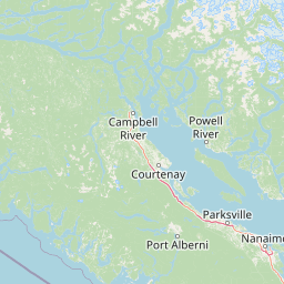
Map view of Háthayim Marine Provincial Park

Use this park location map to pinpoint Háthayim Marine Provincial Park in Canada, understand its exact geographic position, and read its mapped placement within the surrounding landscape more clearly.

Pigeon | © OpenStreetMap contributors

Location context for Háthayim Marine Provincial Park

British Columbia
Park atlas

Compare adjacent marine reserves and island channel landscapes across the Discovery Islands region.

Parks Near Háthayim Marine Provincial Park and Related Coastal Protected Areas

Explore other protected areas sharing the marine geography and sheltered coastal channels surrounding Háthayim Marine Provincial Park. Comparing nearby island reserves reveals the wider ecological patterns connecting the Salish Sea and Vancouver Island.
A watercolor painting of a serene landscape featuring calm water, small islands with pine trees, and rolling hills in the background.
Marine protected areaBritish Columbia
About 15 km away#1 closest

Southeast

Desolation Sound Marine Provincial Park: Mapped Geography and Protected Area Overview

Coastal terrain and marine protected zones in British Columbia

Explore the distinct geographic features of Desolation Sound Marine Provincial Park, a vital marine protected area on the coast of British Columbia. The landscape is defined by deep inlets, glaciated valleys, and essential kelp forest habitats that support a wide range of marine life. This detailed map-based overview provides insights into the park's structural complexity and its role as a key protected site within the regional British Columbia coastal corridor.

Area
84 km²
Established
1973
IUCN
II
Relief
Mountain
State or regional parkBritish Columbia
About 25 km away#2 closest

South

Mitlenatch Island Nature Provincial Park: Protected Coastal Geography and Marine Sanctuary Atlas

Coastal landscapes and protected seabird habitats in British Columbia

Mitlenatch Island Nature Provincial Park represents a specialized coastal refuge defined by grass-topped rocky outcrops and sheltered intertidal zones. This protected area in the Strait of Georgia functions as an important sanctuary for nesting seabird colonies and seasonal marine mammal populations, demonstrating how compact island geography provides high-density habitat within the broader British Columbia ecosystem.

Area
1.55 km²
Established
1961
IUCN
Ia
Relief
Lowland
Protected areaStrathcona Regional District
About 37 km away#3 closest

North

Pałəmin/Estero Basin Conservancy: Geography and Protected Area Map of Northern Vancouver Island

Coastal forest and estuarine basin protected landscape

Located at the head of the Frederick Arm, Pałəmin/Estero Basin Conservancy offers a unique study in vertical coastal geography. Spanning from the tidal margins of the Estero Basin to the slopes near Egerton Peak, this protected area features a diverse landscape of temperate forests and sheltered marine inlets essential to the North Coast ecosystem.

Area
29.78 km²
Established
2007
IUCN
II
Relief
Mountain
Protected areaStrathcona Regional District
About 50 km away#4 closest

Northwest

Phillips Estuary/ʔNacinuxʷ Conservancy: Geographic Mapping and Protected Area Context

Coastal river valley and estuarine conservation on Vancouver Island

Delve into the geography of the Phillips Estuary/ʔNacinuxʷ Conservancy, where riverine systems meet the marine coastline of the Strathcona Regional District. This protected area represents an essential transition zone, featuring forested uplands and tidal flats that form a continuous conservation landscape. Its mapping reveals the interconnected nature of the Phillips River valley, highlighting the ecological value of these protected lands for coastal researchers and geography enthusiasts.

Area
14.61 km²
Established
2007
IUCN
II
Protected areaBritish Columbia
About 67 km away#5 closest

Northwest

Forward Harbour/Yexeweyem Conservancy Protected Area Geography and Coastal Atlas

Coastal wilderness protected landscape on Vancouver Island.

Forward Harbour/Yexeweyem Conservancy preserves a distinct segment of British Columbia coastline. Featuring the Thynne Peninsula and sheltered sections of Bassborough Bay, this remote protected area emphasizes the preservation of marine inlets and salmon habitats within a traditional Indigenous landscape.

Area
3.06 km²
Established
2007
Access
Remote access
Scope
Terrestrial
Watercolor painting of a tranquil body of water with gentle hills in the background and a cluster of trees on the right shore.
State or regional parkBritish Columbia
About 90 km away#6 closest

Southeast

Jedediah Island Marine Provincial Park: Coastal Terrain and Regional Protected Area Map

Mapping island boundaries and sheltered maritime ecosystems

Jedediah Island Marine Provincial Park offers a unique study in coastal geography, featuring a complex shoreline of pebble beaches and indented bays. Located within the Strait of Georgia, the park serves as a protected landmass that blends maritime forest ecosystems with open water corridors. Its boat-only access ensures the landscape remains a quiet, preserved example of Gulf Islands terrain.

Area
6.03 km²
Established
1995
IUCN
II
Relief
Lowland
State or regional parkBritish Columbia
About 93 km away#7 closest

South

Horne Lake Caves Provincial Park: Mapped Protected Landscapes and Cave Networks

Vancouver Island protected area and karst geography

Horne Lake Caves Provincial Park protects a distinct array of limestone cave systems, including Main, Riverbend, and Euclataws caves. The area bridges underground geological formations with surface-level river recreation along the Qualicum River, providing a comprehensive look at the karst and forested terrain of central-eastern Vancouver Island.

Area
1.58 km²
Established
1971
IUCN
II
Relief
Upland
A soft watercolor illustration depicting a winding river flowing through a lush green valley with coniferous forests on the hillsides and mountains in the background.
State or regional parkBritish Columbia
About 99 km away#8 closest

South

Little Qualicum Falls Provincial Park: Regional Protected Landscape and Atlas Geography

River canyon and mountain lake habitat in British Columbia

Explore the structured geography of Little Qualicum Falls Provincial Park, a protected area characterized by its sequence of dramatic river cascades and old-growth Douglas Fir stands. This entry maps the park's key natural features, including the Cameron Lake shoreline and the rugged canyon terrain of the Little Qualicum River.

Area
4.4 km²
Established
1940
IUCN
II
Relief
Mountain

Common questions about visiting, size, designation, and location context for Háthayim Marine Provincial Park

Háthayim Marine Provincial Park FAQs for park facts, access, geography, and protected area context

Find quick answers about Háthayim Marine Provincial Park, including protected-area facts, park geography, trail and visitor context, and how the park fits into its surrounding country and regional landscape.
MoriAtlas Explorer

Continue Your Protected Areas Search Across the Global Atlas

Deepen your exploration by continuing the structured search for national parks and protected areas worldwide. Utilize the comprehensive filtering capabilities to compare different conservation landscapes and refine your understanding of global park geography. Discover more about the distribution and characteristics of protected natural areas.

Global natural geography

