

Mori Atlas logo
Nature reserveHohe Acht

A study of volcanic basalt terrain and protected forest ridges in Rheinland-Pfalz

Hohe Acht Nature Reserve: Exploring the Geography of the Highest Peak in the Eifel Highlands

Hohe Acht stands as the highest point in the Eifel range of Germany, rising 746 meters above the Hocheifel highland in Rheinland-Pfalz. Recognized as a protected nature reserve, this peak serves as an iconic example of an eroded volcanic neck, where exposed basalt formations pierce the surrounding forest cover. The mountain remains a significant geographic landmark within the Rhenish Massif, offering extensive views across the neighboring hills and valleys of the region.

Eifel highlandshighest peakvolcanic ruinbasalt summitRhenish Massifforested upland

Hohe Acht

Nature reserve

Park overview

Structured park overview, official facts, and landscape profile for Hohe Acht

Hohe Acht park facts, protected area profile, and essential visitor context

Review the core facts for Hohe Acht, including designation, size, terrain, visitor scale, habitats, and operating context in one park-focused overview.

About Hohe Acht

Hohe Acht is the highest summit of the Eifel, a low mountain range in the western part of Germany that forms part of the Rhenish Massif. Located in the eastern High Eifel (Hocheifel) of Rhineland-Palatinate, the mountain reaches 746 m above sea level and lies just east of the small town of Adenau. The peak marks the boundary between two districts, Ahrweiler to the north and Mayen-Koblenz to the south, and is surrounded by the forested ridges and rolling highlands typical of the broader Eifel landscape.

The mountain is an eroded remnant of ancient volcanic activity. Its bedrock consists of basanite, a basaltic rock formed roughly 36 to 37 million years ago during the Tertiary period, when the region was part of the Hocheifel volcanic field. Long after the original volcanic structures were worn down, their tougher basalt cores remained as domes. Hohe Acht is one of the most prominent examples of this so-called 'volcanic ruin' (Vulkanruine) in the area, with its summit slopes marked by scattered basalt boulders, loose block fields, and exposed rock outcrops that hint at the mountain's geological origins.

Today the summit carries a strong cultural layer in addition to its natural character. The Kaiser-Wilhelm-Turm, a stone observation tower built in 1908 and 1909 to mark the silver wedding anniversary of Kaiser Wilhelm II and as a memorial to Kaiser Wilhelm I, rises about 16 m above the peak and has become the mountain's defining landmark. Open to the public after multiple restorations, including a major renovation completed in 2015, the tower offers wide panoramic views and anchors Hohe Acht as both a hiking destination and a historical lookout point.

The mountain is also closely tied to the outdoor culture of the Eifel. Marked long-distance trails such as the Eifelleiter pass near the summit, connecting Bad Breisig with Adenau, and networks of cross-country ski and sledding routes extend across its slopes in winter. Protected for over fifty years as the Naturschutzgebiet Hohe Acht, the mountain continues to function as a focal point for regional nature conservation, hiking, and winter recreation in the heart of the German low mountain landscape.

Quick facts and research context for Hohe Acht

Hohe Acht is a 746 m mountain near Adenau in the Eifel range of Rhineland-Palatinate, Germany. It is the highest peak in the entire Eifel and lies in the Hocheifel natural region, which forms part of the broader Rhenish Massif. The summit straddles the boundary between the Ahrweiler and Mayen-Koblenz districts, and it lies within a designated nature reserve (Naturschutzgebiet) first established in 1970 covering about 1.67 square kilometers.

Geologically, the mountain is a so-called 'volcanic ruin' (Vulkanruine), formed from the eroded remains of a Tertiary basaltic volcano that has been exposed as a hard basalt neck rising above the surrounding landscape. Its summit is marked by the Kaiser-Wilhelm-Turm, a 16.3 m stone observation tower built in 1908 to 1909, now a protected cultural monument. The mountain is also a popular hiking destination and seasonal winter sports area within the broader Eifel recreation landscape.

Protection and recognition

Analysis of the documented terrestrial protected area designation and management scope established in 1970

Hohe Acht Protection Status and Designated Terrestrial Conservation History

Hohe Acht maintains a recorded terrestrial protection status established in 1970 within international conservation databases. Archival records outline the official designation timeline, administrative scope, and recognition parameters for this protected landscape.

Protection details

Protection scope
Terrestrial
Designated year
1970
Transboundary protection
No
WDPA ID
81906
Park context

Deeper park guide and search-rich context for Hohe Acht

Hohe Acht history, landscape, wildlife, and travel context

Explore Hohe Acht through its history, landscape character, ecosystems, wildlife, conservation priorities, cultural context, and seasonal travel timing in a structured park guide built for atlas discovery and search intent.

Why Hohe Acht stands out

Hohe Acht is best known as the highest mountain of the Eifel range, a position that gives it an iconic presence in the regional geography of western Germany. Its summit rises above deeply forested terrain in the Hocheifel highland, offering panoramic views over a vast arc of the Rhenish Massif, including the Eifel, the Siebengebirge, the Westerwald, the Taunus, and the Hunsrück on clear days. Equally distinctive is its origin as an ancient volcanic remnant. The mountain is a so-called Vulkanruine, with its basalt neck exposed by millions of years of erosion rather than the original volcanic cone. This geological character, paired with its protected nature reserve status and its landmark Kaiser-Wilhelm-Turm, gives Hohe Acht a layered identity that combines natural history, scenic hiking terrain, and cultural heritage in a single prominent peak.
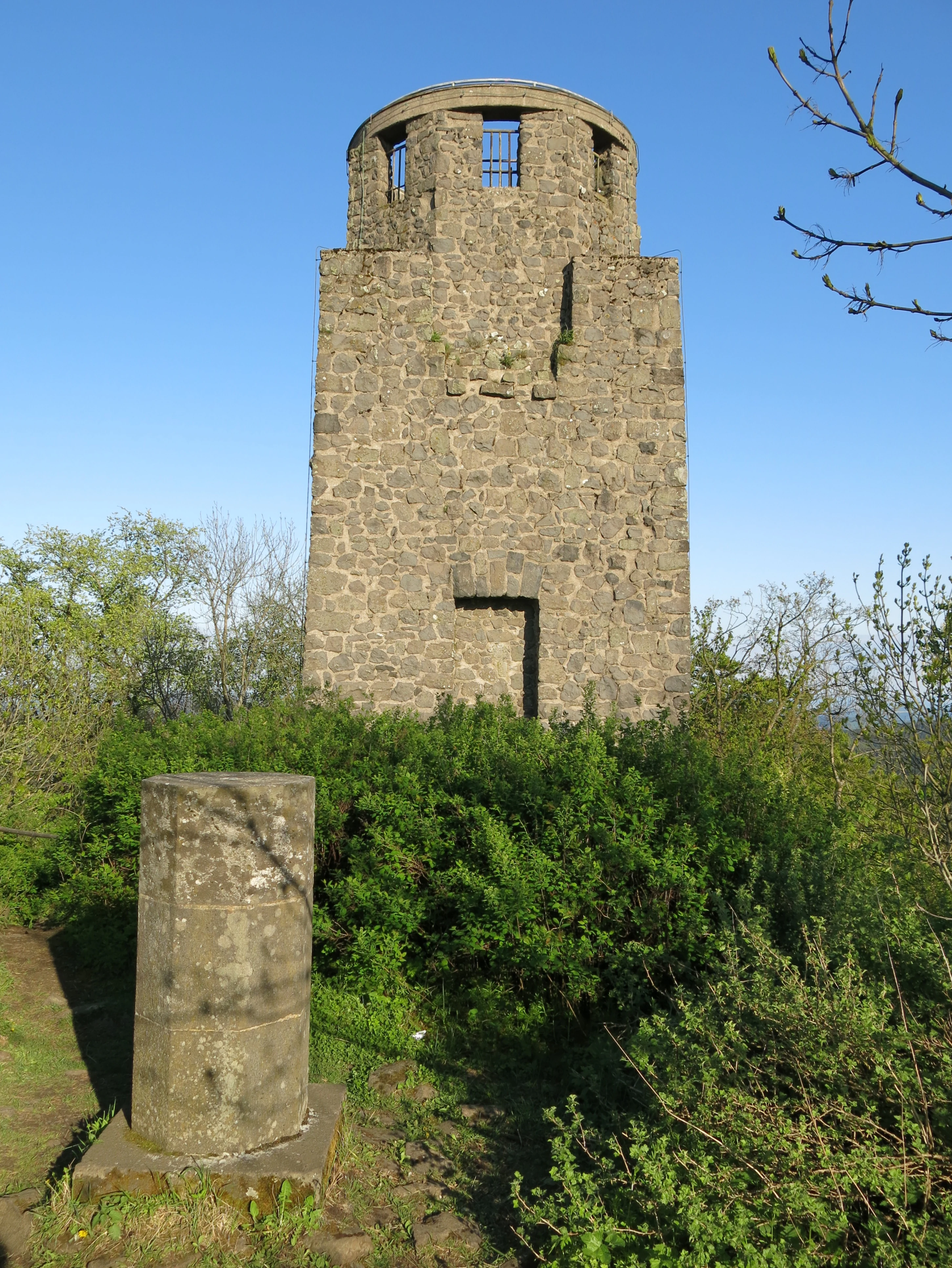
Kaiser Wilhelm Tower
The Kaiser Wilhelm Tower on Hohe Acht in the Eifel region, viewed from the west.

Hohe Acht history and protected-area timeline

The mountain's modern history is closely linked to the founding and stewardship traditions of German nature conservation and outdoor recreation. In 1970, the area around the summit was designated as the Naturschutzgebiet Hohe Acht, marking one of the earliest formal protections of the peak and its surroundings. Today the protected zone covers roughly 1.67 square kilometers, while additional landscape and bird protection layers, including the larger Rhein-Ahr-Eifel Landschaftsschutzgebiet and the Ahrgebirge Vogelschutzgebiet, extend further across the mountain's flanks.

The mountain's human story, however, is most visibly defined by the Kaiser-Wilhelm-Turm. The tower was erected in 1908 and 1909, designed by the Berlin architect Wilhelm Freiherr von Tettau and built by master masons Karl and Johannes Leidinger from Adenau using local quarry stone. Standing 16.3 m tall, it was inaugurated on 23 June 1909, and its construction was funded at a cost of 18,000 Mark. The project commemorated both the silver wedding anniversary of Kaiser Wilhelm II and the memory of Kaiser Wilhelm I, giving the mountain a prominent national monument at its summit.

After the Second World War, the tower initially served military purposes. It was first occupied by French forces and later used by a United States radar unit until 1959, after which it was returned to public use. Renovations in 1961 replaced the original interior staircases with concrete steps, and further repairs in the mid-1980s, costing more than 100,000 Deutsche Mark, ensured the structure's continued stability. Since 1987, the tower itself has been officially listed as a protected cultural monument (Denkmalschutz), and a 30,000-euro renovation completed in April 2015 marked its most recent restoration, returning the tower to public climbing and visitor use.

Earlier parts of the mountain's recreational history include the construction in 1934 of a ski jumping hill on the northeast slope by the Turn- und Wintersport-Verein Adenau. In use for over four decades, the jump saw traditional New Year's competitions and a hill record of 22.5 m set in 1955 by Karlheinz Buchholz. The ski jump was eventually abandoned in 1980, ending that chapter of the mountain's sporting life, though the broader tradition of winter sport on its slopes has continued through cross-country skiing, sledding, and small ski lifts.

Hohe Acht landscape and geographic character

Hohe Acht sits within the Hocheifel highland, a deeply forested section of the eastern Eifel where broad upland ridges rise above quiet valleys. The summit itself rises 746 m above sea level, making it the highest point in the entire Eifel, and its prominence continues for tens of kilometers across the surrounding terrain. With 62.9 km of topographic dominance and 525 m of relative height to the nearest saddle, the mountain stands as a clear regional high point in the western Rhenish Massif.

The physical character of the peak reflects its volcanic origins. Below the summit, the slopes are scattered with basalt blocks, loose rock debris, and rugged basalt outcrops that mark the eroded remains of the ancient volcano's central vent. These stony zones contrast with the surrounding forest cover, which cloaks the mountain in mixed woodland typical of the High Eifel. As a volcanic ruin, the summit offers a more open, rocky terrain than the smoother ridges around it, with clear, broad viewpoints toward the Hunsrück to the south, the Siebengebirge to the northeast, and, on the clearest days, the Westerwald, Taunus, and Lower Rhine region beyond.

In addition to its summit geology, the surrounding mountain landscape includes the rolling sub-ridges of the Hohe-Acht-Bergland and the broader Hohe-Acht/Nitz-Nette-Bergland natural sub-unit. To the southwest, the slopes transition toward the hill on which the medieval Nürburg castle ruins stand, while to the east the terrain descends gently into the Ahrgebirge and the broader Rhineland-Palatinate uplands. This combination of exposed basalt ridge, forested slopes, and broad surrounding valleys gives Hohe Acht a landscape identity that is at once dramatically geological and classic to the Eifel.
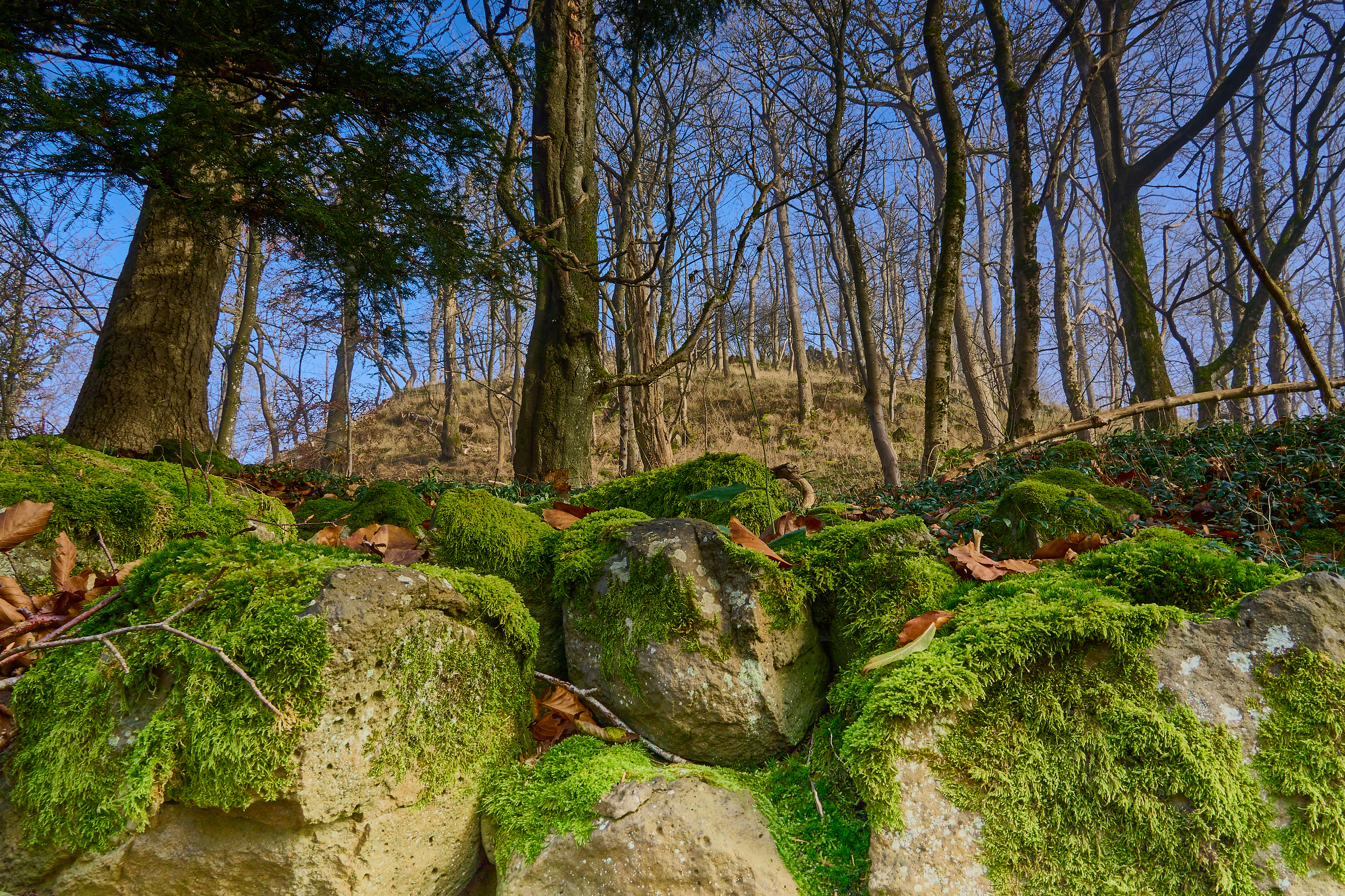
Hohe Acht summit scree
Volcanic scree at the summit base of Hohe Acht

Hohe Acht ecosystems, habitats, and plant life

The natural character of Hohe Acht is defined by its mixed forest cover and its position within one of Rhineland-Palatinate's most substantial protected upland landscapes. The summit and its slopes are dominated by woodland of the kind typical of the High Eifel, interspersed with grassy clearings and rocky basalt outcrops. These habitats provide a controlled environment for the protected species of the Ahrgebirge area and form an important part of the mountain's broader ecological role.

Within the designated Naturschutzgebiet Hohe Acht, the protected land covers roughly 1.67 square kilometers around the summit, while the surrounding flanks fall within the much larger Rhein-Ahr-Eifel Landschaftsschutzgebiet (925.86 square kilometers, designated in 1980) and within the Ahrgebirge bird protection zone (304 hectares). This layered protection framework reflects the mountain's value as a refuge not only for forest species but also for breeding and migratory bird populations, supported by the mixed habitats of forest edge, rocky summit, and adjacent meadow landscapes.

Ecologically, the area functions primarily as upland woodland with volcanic geological substrate, where basalt-derived soils support characteristic High Eifel vegetation patterns. The combination of elevation, exposure, bedrock type, and protection status makes the mountain a small but ecologically meaningful stronghold within the Eifel nature conservation system.
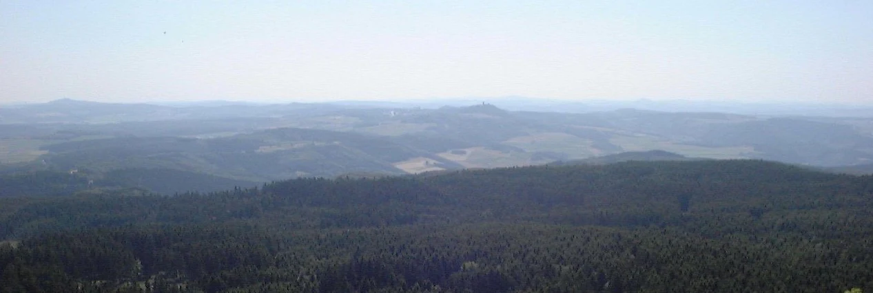
View of Nurburg from Hohe Acht
A view of Nurburg castle as seen from the summit of the Hohe Acht mountain

Hohe Acht wildlife and species highlights

Because Hohe Acht sits within both the Naturschutzgebiet Hohe Acht and the broader Ahrgebirge Vogelschutzgebiet, the mountain is recognized for its birdlife as well as for the typical forest fauna of the High Eifel. The rocky summit, open basalt habitats, and surrounding mixed woodlands provide diverse conditions for resident and migratory bird species, making the area a focus of regional ornithological conservation rather than a high-density mammalian wildlife zone.

The mountain's broader role in the regional ecosystem is tied to the protected landscapes around it. The large Rhein-Ahr-Eifel Landschaftsschutzgebiet and the adjoining bird protection area together create a network of habitats that supports the typical Eifel wildlife community, from forest-dwelling species of the mixed woodlands to the bird populations of the upland clearings and rocky zones near the summit. The mountain's conservation framework is therefore less about charismatic large mammals and more about maintaining a functioning mosaic of forest, rock, and meadow habitats characteristic of the High Eifel.

Hohe Acht conservation status and protection priorities

Hohe Acht has been at the center of regional nature conservation efforts in Rhineland-Palatinate since 1970, when the summit area was formally designated as the Naturschutzgebiet Hohe Acht. With an area of around 1.67 square kilometers, this protected zone safeguards the mountain's most ecologically distinctive terrain, including its forested slopes, basalt outcrops, and open summit habitats. Beyond the immediate nature reserve, much of the surrounding mountain falls within the larger Rhein-Ahr-Eifel Landschaftsschutzgebiet, designated in 1980 across 925.86 square kilometers, providing a broader landscape protection buffer.

The mountain also contributes to bird conservation. It lies partially within the Ahrgebirge Vogelschutzgebiet, a designated bird protection area of approximately 304 hectares that covers much of the surrounding upland. Together, these three overlapping protection categories; nature reserve, landscape protection area, and bird protection area; place Hohe Acht at the intersection of multiple conservation priorities, from habitat preservation to ornithological safeguarding. This layered protection recognition underlines the mountain's role as a smaller but ecologically significant stronghold within the broader conservation landscape of the Eifel.

Hohe Acht cultural meaning and human context

Hohe Acht has long been embedded in the regional outdoor and hiking culture of the Eifel. The Eifelverein, the regional hiking and nature association, has historically maintained trails and lookout infrastructure across the mountain, and the summit remains a focal stopping point along major routes such as the Eifelleiter, a long-distance path running from Bad Breisig to Adenau. These traditions reflect a broader German culture of organized, voluntary stewardship of hiking and observation sites, which has been central to the mountain's identity since the early twentieth century.

Culturally, the mountain is also marked by the Kaiser-Wilhelm-Turm, a stone observation tower built in 1908 and 1909 to commemorate the silver wedding anniversary of Kaiser Wilhelm II, and as a memorial to Kaiser Wilhelm I. Since its post-war return to public use, and through later restorations including the 2015 renovation, the tower has come to symbolize a layered cultural memory, blending imperial commemoration, mid-twentieth-century military repurposing, and contemporary public outdoor recreation. As a listed cultural monument since 1987, the tower remains one of the most recognizable historical landmarks in the High Eifel.

For local communities, including Adenau and surrounding villages such as Herresbach, Jammelshofen, and Siebenbach, the mountain is part of everyday regional identity. Seasonal traditions such as winter sports on its slopes and historic events like the New Year ski jumping competitions of the mid-twentieth century have linked the mountain to community life for generations, even as the landscape itself is primarily valued today for hiking, quiet outdoor experience, and panoramic views of the broader Rhenish highlands.

Top sights and standout views in Hohe Acht

Hohe Acht is the highest summit of the entire Eifel, reaching 746 m above sea level near Adenau in Rhineland-Palatinate. The mountain is a classic Vulkanruine, an eroded volcanic remnant whose basalt neck now stands exposed above deeply forested slopes. The historic Kaiser-Wilhelm-Turm, a stone observation tower built in 1908 to 1909, crowns the summit and offers sweeping views toward the Siebengebirge, Westerwald, Taunus, and Hunsrück.

The mountain has been protected as the Naturschutzgebiet Hohe Acht since 1970, and its flanks also fall within the larger Rhein-Ahr-Eifel landscape protection zone and the Ahrgebirge bird protection area. Long-distance trails such as the Eifelleiter pass near the summit, while traditional winter sports routes still follow its slopes each season, making the mountain a year-round destination for outdoor experience in the western Rhenish Massif.

Best time to visit Hohe Acht

The clearest and most rewarding conditions for visiting Hohe Acht generally occur in late spring through early autumn, when the summit area is accessible for hiking and the panoramic views from the Kaiser-Wilhelm-Turm extend furthest across the Eifel, the Siebengebirge, and the surrounding Rhenish Massif. Warmer months are ideal for combining the summit visit with longer-distance trails such as the Eifelleiter, allowing time to appreciate the forested slopes and basalt outcrops at a comfortable pace.

In winter, the mountain takes on a different character, becoming one of the more popular cold-season destinations in the eastern Eifel. Snow conditions in the area often permit cross-country skiing on prepared tracks, sledding on local routes, and use of nearby ski lifts on the mountain's flanks. Although the former ski jumping hill is no longer in operation, the broader winter sports tradition continues, and the frost-covered basalt and forest scenery give the peak a distinctly seasonal atmosphere that contrasts with the lush green hiking season.

Monthly climate preview

Long-term representative measurements illustrating monthly weather variations across Hohe Acht

Hohe Acht Climate Normals: Annual Temperature and Precipitation Rhythm

Representative coordinates record measured multi-year temperature variations and monthly precipitation rates across the elevation profile. Analyzing complete twelve-month normals provides detailed insight into long-term climate patterns for Hohe Acht.
Annual mean9 °C
0 °C18 °C
Jan
Feb
Mar
Apr
May12°
Jun15°
Jul18°
Aug18°
Sep14°
Oct
Nov
Dec
Warmest month
July

17.9 °C

Coolest month
January

0 °C

Wettest month
June

2.5 mm/day

Driest month
April

1.6 mm/day

Park location guide

Geography guide, regional context, and park location map for Hohe Acht

Hohe Acht park geography, regions, and map view in Germany

Understand where Hohe Acht sits in Germany through a broader geographic reading of the surrounding landscape, nearby location context, and its mapped position within the national park landscape.

How Hohe Acht fits into Germany

Germany is a federal republic in Western and Central Europe with a population of over 83 million across sixteen constituent states. It is Europe's largest economy by nominal GDP and a major global exporter and importer. The capital is Berlin, and the country borders Denmark, Poland, Czech Republic, Austria, Switzerland, France, Luxembourg, Belgium, and the Netherlands.

Wider geography shaping Hohe Acht in Germany

Germany is located in Western and Central Europe, spanning 357,022 km². It borders Denmark to the north, Poland and the Czech Republic to the east, Austria and Switzerland to the south, and France, Luxembourg, Belgium, and the Netherlands to the west. The country has coastlines on the Baltic Sea and North Sea to the north, with the Alps located in the southern region.

Map view of Hohe Acht

Use this park location map to pinpoint Hohe Acht in Germany, understand its exact geographic position, and read its mapped placement within the surrounding landscape more clearly.

Pigeon | © OpenStreetMap contributors

Location context for Hohe Acht

Rheinland-Pfalz

Explore visual records of the basalt summit, forested volcanic slopes, and protected highland scenery.

Hohe Acht Photos and Landscape Imagery: Visualising the Highest Eifel Peak

Visual documentation reveals the exposed basalt outcrops, stone strewn hillsides, and dense mixed woodland that define the highest point in the Eifel range. Examining photographic records provides a clearer understanding of the terrain, volcanic geology, and protected landscape character surrounding the summit.

Kaiser Wilhelm Tower

Hohe Acht

Hohe Acht summit scree

View of Nurburg from Hohe Acht

Park atlas

Compare surrounding volcanic summits, forested ridges, and regional protected landscapes.

Explore Protected Areas and Parks Near Hohe Acht in the Eifel Highlands

Browsing parks near Hohe Acht reveals connected volcanic terrain, forested uplands, and protected reserves across the surrounding Rhenish highlands. Comparing adjacent protected areas provides deeper geographic context for the broader regional landscape.
Nature reserveRhineland-Palatinate
About 4.5 km away#1 closest

East

Wacholderheiden Raßberg und Heidbüchel: Protected Juniper Heathland in Rhineland-Palatinate

Mapping traditional Eifel bergheide landscapes

Located in the Arft municipality, this nature reserve protects two distinct sections of Raßberg and Heidbüchel. The area is defined by its characteristic juniper-dotted slopes that exemplify the rare mountain-heath ecosystems once common across the German uplands. This site serves as a vital anchor for regional habitat conservation within the broader Rhein-Ahr-Eifel landscape context.

Area
0.24 km²
Established
1981
Relief
Upland
Scope
Terrestrial
Nature reserveRhineland-Palatinate
About 4.8 km away#2 closest

East

Nettetal Nature Reserve: Geography and Protected Boundaries in Rhineland-Palatinate

Steep-sided valley landscapes and biodiversity corridors.

Nettetal Nature Reserve offers a deep look into the geomorphology of a classic Kerbtal in Rhineland-Palatinate. This protected area along the Nette tributary showcases a rare density of contrasting terrains, from sun-exposed rock formations to damp valley floors, providing a clear window into regional conservation mapping.

Area
7.05 km²
Established
1986
Scope
Terrestrial
Water
Major water bodies
Nature reserveRheinland-Pfalz
About 7.6 km away#3 closest

Southwest

Quiddelbacher Höhe / Nürburgring Nature Reserve: A Protected Highland Plateau in the Eifel

Explore the regional geography and conservation landscape of Rheinland-Pfalz

Quiddelbacher Höhe / Nürburgring protects a distinct highland plateau surface known for its rare vegetation and critical role in local ecological conservation. Situated near major transit corridors and the famous racing circuit, the site provides a quiet, open landscape contrast within the larger Ahrweiler region of Germany.

Area
0.27 km²
Established
2002
Relief
Upland
Climate
Temperate
Nature reserveRhineland-Palatinate
About 11 km away#4 closest

East

Lehrenkopf Nature Reserve: Mapped Volcanic Terrain and Regional Eifel Geography

Geological landscape and protected botanical site in Ahrweiler

Lehrenkopf stands as a compact nature reserve characterized by its 496-meter volcanic hill, which anchors the botanical and geological identity of the site. Spanning across the municipal territories of Kempenich and Brenk, this protected area serves as a focal point for regional conservation within the Eifel, emphasizing the preservation of rare wild plant species and the maintenance of distinct skyline features in the Ahrweiler district.

Area
0.35 km²
Established
1989
IUCN
IV
Relief
Mountain
Nature reserveRheinland-Pfalz
About 14 km away#5 closest

East

Hochsimmer Nature Reserve: Volcanic Topography and Forested Highlands of the Eastern Eifel

A study of basaltic twin cones and protected regional wilderness

Hochsimmer is a well-defined volcanic cinder cone near the Mayen-Koblenz district, characterized by its twin-peak profile and expansive woodland canopy. This protected nature reserve anchors the local topography where the volcanic Eifel meets the Middle Rhine basin, offering an essential reference for understanding the geological and ecological structure of the Rhineland-Palatinate high country.

Area
2.491 km²
Established
1973
Relief
Mountain
Climate
Temperate
Nature reserveRhineland-Palatinate
About 15 km away#6 closest

East

Hochstein Nature Reserve: Geological Mapping and Protected Eifel Landscape Context

An extinct volcanic cone protected within Rhineland-Palatinate

Hochstein stands as a representative Vulkanberg in the Osteifel, offering a clear visual landmark of Germany's volcanic history. This protected nature reserve encompasses forested slopes, the storied Genoveva Cave, and the surrounding drainage basins of the Nette river system, providing a deep look into the regional geology and conservation boundaries of the Middle Rhine highland.

Area
3.511 km²
Established
1983
Relief
Mountain
Scope
Terrestrial
Nature reserveNorth Rhine-Westphalia
About 17 km away#7 closest

West

Vogelschutzgebiet Ahrgebirge Nature Reserve, North Rhine-Westphalia Protected Landscape

Mapped ridge terrain and woodland habitat in the western Eifel region

The Vogelschutzgebiet Ahrgebirge serves as a significant nature reserve protecting the North Rhine-Westphalian side of the Ahrgebirge ridge. Its geography consists of dense, near-natural deciduous forests, stream-cut valleys, and deadwood habitats that provide breeding ground for specialist avian species, forming part of a larger interconnected network across the Rhenish Slate Mountains.

Area
5.8 km²
Established
2004
Protected areaRheinland-Pfalz
About 17 km away#8 closest

East

Mayener Grubenfeld: Protected Industrial Landscapes and Volcanic Terrain in Germany

A historic basalt mining district and vital bat hibernation hub

The Mayener Grubenfeld preserves deep traces of volcanic activity and industrial evolution, marked by porous basalt sheets and centuries of extraction. Today, the terrain consists of abandoned quarry pits, gallery systems, and dry grassland habitats that form a protected area of significant geological and ecological value within Rheinland-Pfalz.

Area
1.5 km²
Relief
Upland
Climate
Temperate
Access
Easy access

Common questions about visiting, size, designation, and location context for Hohe Acht

Hohe Acht FAQs for park facts, access, geography, and protected area context

Find quick answers about Hohe Acht, including protected-area facts, park geography, trail and visitor context, and how the park fits into its surrounding country and regional landscape.
MoriAtlas Explorer

Continue Your Protected Areas Search Across the Global Atlas

Deepen your exploration by continuing the structured search for national parks and protected areas worldwide. Utilize the comprehensive filtering capabilities to compare different conservation landscapes and refine your understanding of global park geography. Discover more about the distribution and characteristics of protected natural areas.

Global natural geography