
Mori Atlas logo
Protected landscapeHohe Schrecke

A detailed map and regional overview of the unfragmented beech woodlands and sandstone ridges of central Germany.

Hohe Schrecke Protected Landscape: Understanding the Geography and Forested Terrain in Thuringia

Hohe Schrecke represents a uniquely continuous expanse of deciduous forest situated within the eastern part of Thuringia. This protected landscape encompasses low mountain ridges defined by Buntsandstein geology, where deep stream-cut valleys and remnant orchard meadows create a diverse ecological mosaic. By mapping the forest boundaries and regional terrain, this record provides clear insight into one of Germany's most ecologically coherent nature reserves.

low mountain ridgebeech forestdeciduous forestnature reserveFFH sitebird sanctuary
A colorful digital illustration of a scenic valley with a sun in the sky, green trees, patches of wildflowers in the foreground, and a distant waterfall cascading down a cliff face.

Hohe Schrecke

Protected landscape

Park overview

Structured park overview, official facts, and landscape profile for Hohe Schrecke

Hohe Schrecke park facts, protected area profile, and essential visitor context

Review the core facts for Hohe Schrecke, including designation, size, terrain, visitor scale, habitats, and operating context in one park-focused overview.

About Hohe Schrecke

Hohe Schrecke is a forested low mountain ridge in eastern Thuringia, falling partially within the Kyffhäuserkreis and Landkreis Sömmerda and touching the Burgenlandkreis of Saxony-Anhalt where some interpretations of its boundaries extend. Geologically, the range sits on Lower Triassic Buntsandstein, often covered by a veneer of loess, and is enclosed to the north and west by the broad arc of the Unstrut river, a tributary of the Saale.

The landscape of Hohe Schrecke is defined above all by closed, largely unfragmented deciduous forest, dominated by beech and mixed beech woodland, with transitions into oak-hornbeam forest, ash-alder streamside woodland, and small areas of pioneer woodland on formerly cleared ground. Along its margins the forest meets intensively farmed arable land, but pockets of orchard meadows (Streuobstwiesen) and species-rich dry grasslands remain, particularly where agricultural use and forest edge interlock.

Conservation status sits at the heart of the area's modern identity. The 3,437 hectare nature protection area Hohe Schrecke was formally designated in 2004, building on provisional protection that had begun on former military land in 1993. It now overlaps the larger 5,732 hectare FFH and EU Bird Directive site Hohe Schrecke – Finne, which protects a long list of woodland, grassland, heath, and freshwater habitat types alongside Annex II species such as Bechstein's bat, the great mouse-eared bat, the crested newt, and the stag beetle.

The large-scale conservation project 'Hohe Schrecke – Alter Wald mit Zukunft', which ran from 2009 to 2023, set aside more than 2,000 hectares of deciduous forest, including beech stands up to roughly 200 years old, as natural forest where forestry is largely restricted to natural processes. The project also managed around 870 hectares of associated open land, particularly orchard meadows along the forest edge, and was funded jointly by the German Federal Environment Ministry, the Free State of Thuringia, the Naturstiftung David, and the Zoologische Gesellschaft Frankfurt.

Protection and recognition

Documented terrestrial protection history, management scope, and conservation status

Hohe Schrecke Protection Status and Designated Area Recognition

Hohe Schrecke holds a documented terrestrial protection status established in the designated year of 2004. Structured conservation facts outline the official management scope and historical designation context without external international recognitions.

Protection details

Protection scope
Terrestrial
Designated year
2004
Transboundary protection
No
Park context

Deeper park guide and search-rich context for Hohe Schrecke

Hohe Schrecke history, landscape, wildlife, and travel context

Explore Hohe Schrecke through its history, landscape character, ecosystems, wildlife, conservation priorities, cultural context, and seasonal travel timing in a structured park guide built for atlas discovery and search intent.

Why Hohe Schrecke stands out

Hohe Schrecke is best known for its exceptionally large, unfragmented stands of old beech forest, including trees up to around 200 years old that have been formally set aside as natural forest. The continuity of woodland, combined with open transitions into orchard meadows and dry grasslands, gives the range an unusually coherent mix of habitats for a low-elevation German ridge. It is also associated with the recovery of large woodland species typical of mature deciduous forest, especially the European wildcat, the black stork, and red deer, and with a particularly rich assemblage of larger fungi. Together these qualities have made the area one of the most discussed candidate sites for new nature-based forest protection in eastern Germany.
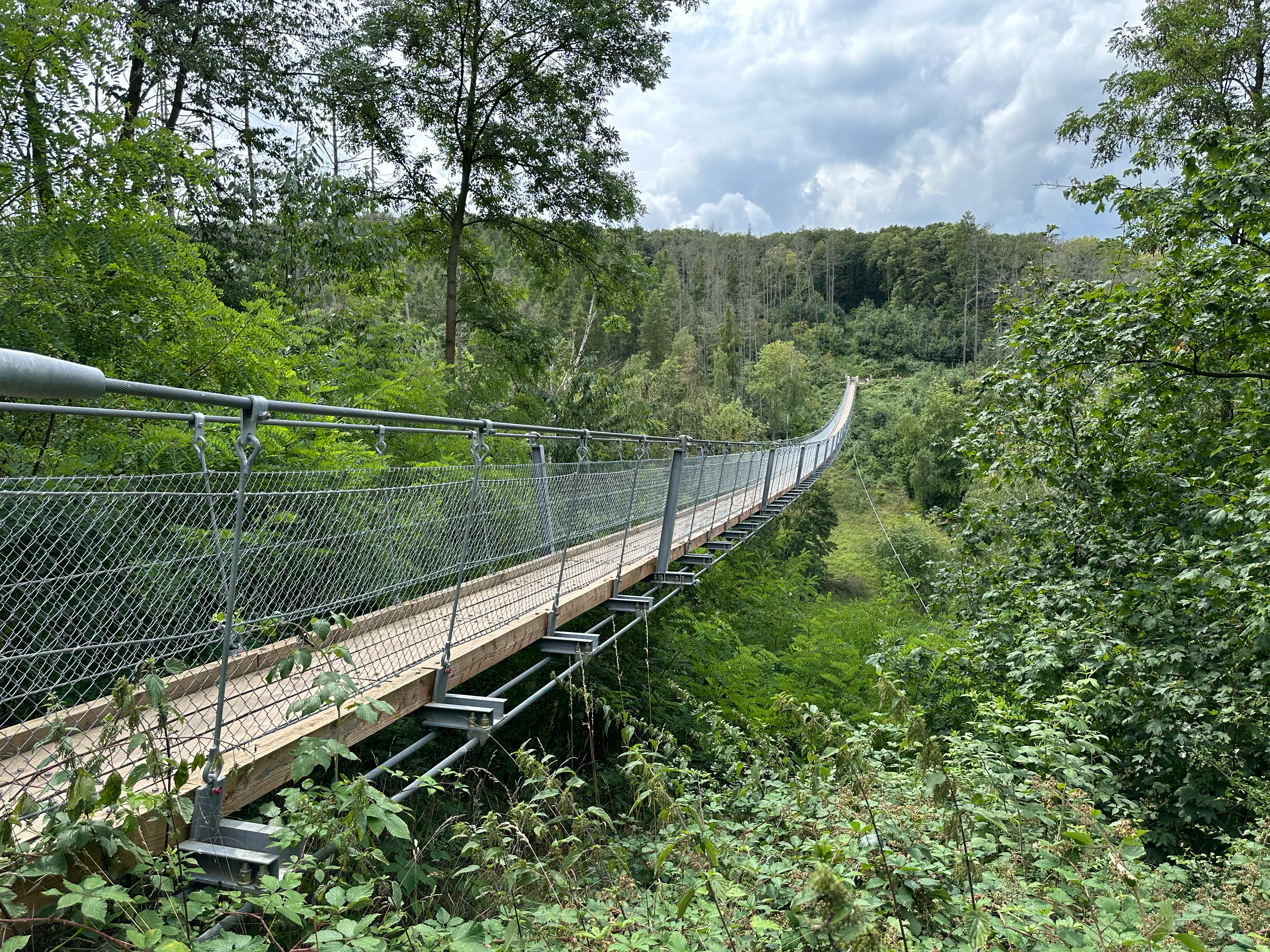
A long, narrow metal and wooden suspension bridge stretches across a lush, green forest canopy, viewed from a slightly elevated angle.
The suspension bridge in the Hohe Schrecke forest area.

Hohe Schrecke history and protected-area timeline

Hohe Schrecke lay within the core territory of the early Thuringian kingdom, and its edges bear the remains of substantial ringwall fortifications and medieval strongholds, including the Monraburg. In the High Middle Ages the range sat within the sphere of the counts of Beichlingen, the counts of Wiehe, and the Thuringian landgraves, who fortified the roads crossing the area with castles such as the Burg Rabenswalde. Economic colonization and settlement reached the interior of the range as well, giving rise to villages such as the later deserted settlement of Wetzelshain.

For several centuries the forest was intensively managed by the Werthern forestry administration, and until the uncompensated expropriation of 1945 the heart of the woodland, roughly 4,900 hectares, remained in the hands of the von Werthern-Beichlingen family. From the 1930s onward the eastern part of the range east of Lossa was used by the German Luftwaffe as an ammunition depot with earth-covered bunkers. In 1945 the Red Army destroyed these installations and disposed of large quantities of munitions in former potash shafts.

Between 1946 and 1948 the Soviet occupation forces cleared roughly 2,000 hectares of forest for a military training area, around which a restricted zone was maintained. Following the withdrawal of Soviet troops in the early 1990s, the Thuringia state development agency was tasked with ordnance clearance and the sealing of bunkers and rocket shafts, but about 3,000 hectares had still not been fully cleared by 2010. The decision taken around 2005 to pursue a large-scale conservation project, rather than simply selling the land, set the stage for the emergence of the modern Hohe Schrecke nature protection area.

Hohe Schrecke landscape and geographic character

Hohe Schrecke is a wooded low mountain ridge of moderate relief, reaching its highest point at the Wetzelshain, about 370 meters above sea level, and including secondary summits such as the Beerberg, Drei-Lindenberg, Seligenbornsberg, Erbsland, and a series of lower hills arranged around the central upland. The terrain is gently rolling rather than dramatic, but the continuity of woodland and the transitions along its margins give the area a strong scenic coherence.

Geologically, the range rests on Buntsandstein, the reddish Lower Triassic sandstone that defines so much of the eastern Thuringian landscape, often overlain by a thin loess cover. Streams have cut shallow valleys into this substrate, producing the small ravines and stream woodlands that today support some of the most ecologically sensitive forest stands. The Unstrut river, a tributary of the Saale, wraps around the range on its northwestern, northern, and northeastern sides, providing a clear hydrological frame.

Where the former Soviet training area stood, open clearings and pioneer woodland now break the otherwise closed canopy, creating visible contrast within the forest belt. At the margins, the forest edge often meets farmland abruptly, although surviving orchard meadows and dry grassland create softer ecological transitions. Since 2019 a steel-and-timber hanging suspension bridge roughly 180 meters long and 25 meters high over the Bärental has added a single distinct built landmark to the otherwise quiet, forested terrain.
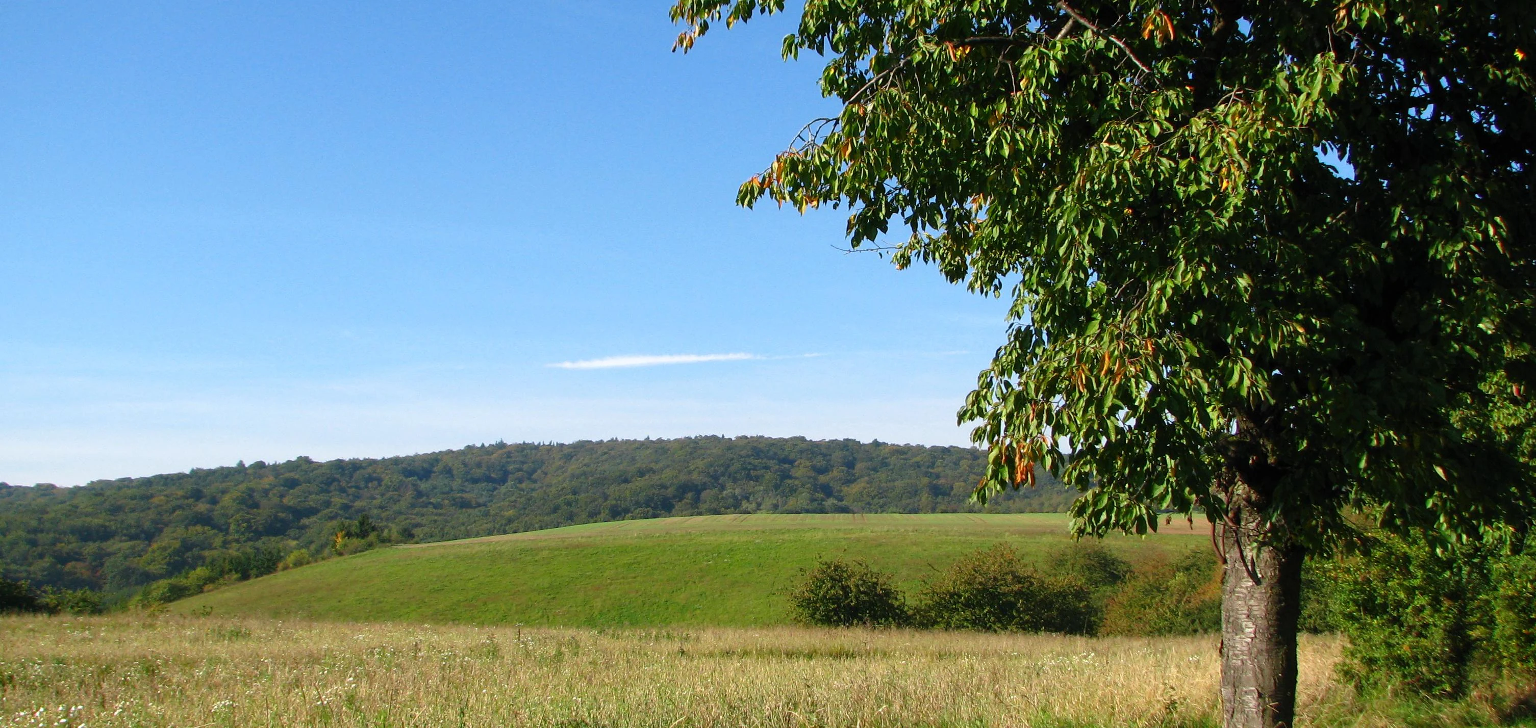
A green hillside and a distant forested ridge under a clear blue sky, with a leafy deciduous tree in the foreground on the right.
A scenic view of the rolling hills and forested ridges of the Hohe Schrecke region.

Hohe Schrecke ecosystems, habitats, and plant life

Ecologically, Hohe Schrecke is dominated by closed, unfragmented deciduous forest, with beech as the leading species. Hainsimsen-Buchenwald and Waldmeister-Buchenwald, the two classic Central European beech forest habitat types, are widespread here, joined by Stellario-Carpinetum and Galio-Carpinetum oak-hornbeam forests on more fertile soils and Tilio-Acerion slope and ravine forests in the steeper stream valleys. Alno-Padion alder and ash woodland occurs along watercourses, while pioneer woodland, mainly birch and pine, has established on the formerly cleared training ground east of Lossa.

The overarching ecological significance of the range lies in its continuity. Unlike many Central European forests, the woodlands of Hohe Schrecke are not dissected by roads, settlements, or large clearings on a regular grid, instead forming an unbroken matrix in which interior-forest species can move and breed across substantial areas. The ridge's margin between closed forest and open land is unusually sharp in places, which supports a distinctive ecological edge where dry grasslands, orchard meadows, and forest form a rich mosaic.

Smaller open habitats are ecologically important as well, despite their limited extent. Natural eutrophic lakes, lowland streams, dry European heaths, orchid-rich Festuco-Brometalia calcareous grasslands, sub-Pannonian steppic dry grasslands, and silicate scree slopes all contribute to habitat diversity. Mesotrophic and calcareous fens, including transition mires and quaking mires, add a wetland component that is otherwise rare in this otherwise dry, sandstone-dominated setting.
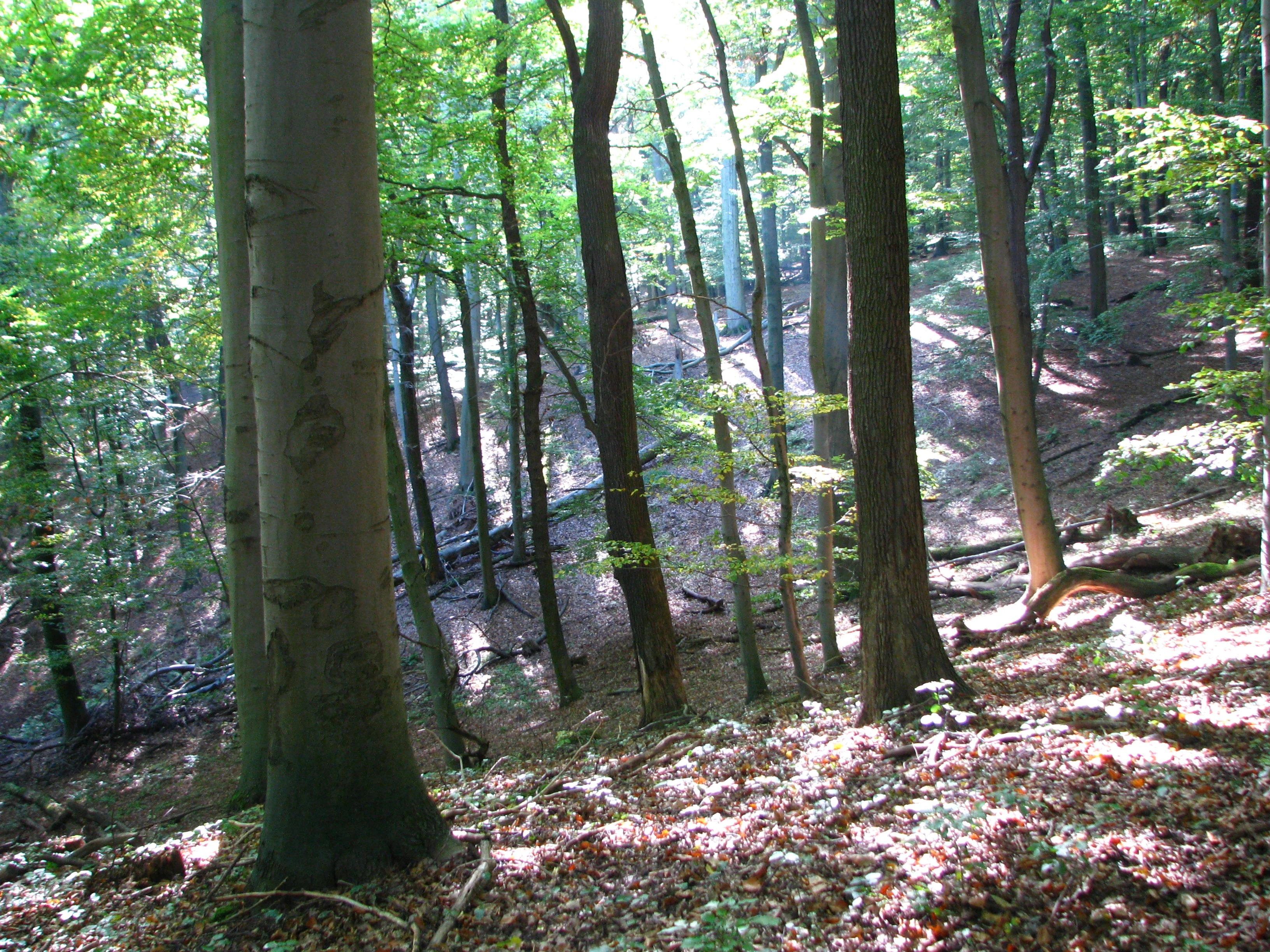
A sloped woodland area filled with tall beech trees, dappled sunlight, and deadwood on the forest floor.
Old-growth beech forest with deadwood in the Hohe Schrecke nature reserve.

Hohe Schrecke wildlife and species highlights

The wildlife profile of Hohe Schrecke is shaped above all by the continuity of mature deciduous forest, which provides habitat for species that depend on large, quiet woodland tracts. The European wildcat is one of the area's flagship mammals, alongside the red deer, which thrives in the unfragmented forest and is at the center of ongoing debates between forest owners and conservationists about management intensity.

Birdlife is a major component of the reserve's identity. The black stork breeds in the range's deeper woodland, and the area is also home to the red kite, the European honey buzzard, the middle spotted woodpecker, the black woodpecker, the grey-headed woodpecker, the Eurasian kingfisher, the Eurasian eagle-owl, the red-backed shrike, and the European pied flycatcher as a breeding species. The site additionally serves as a roosting and resting area for migratory birds including the hobby, the common redstart, the icterine warbler, the Eurasian wryneck, the great grey shrike, the corn bunting, the whinchat, the Eurasian woodcock, and the Eurasian hoopoe.

Bats are particularly important, and three Annex II species are protected here: the Western barbastelle, Bechstein's bat, and the greater mouse-eared bat. Other notable fauna includes the crested newt, the stag beetle, and the narrow-mouthed snail, an invertebrate of conservation interest. Despite being a sandstone ridge, the range also supports a remarkable diversity of larger fungi, with more than 500 macrofungal species recorded, reflecting the age and structural complexity of the woodland.
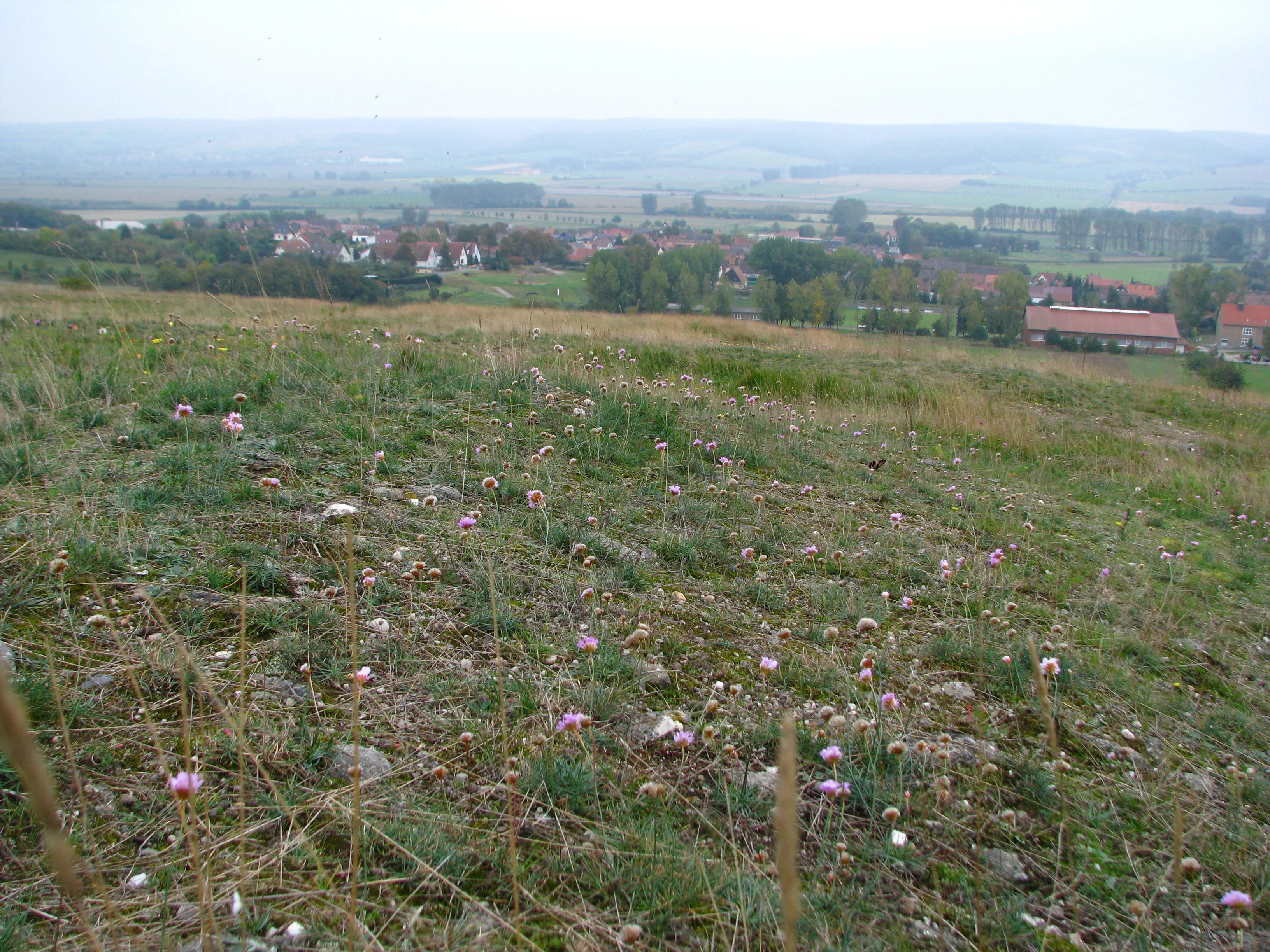
A wide angle view from a grassy hillside with small pink wildflowers in the foreground looking down toward a village and distant forested hills under an overcast sky.
A view overlooking the village of Bottendorf from the surrounding hills towards the Hohe Schrecke ridge.

Hohe Schrecke conservation status and protection priorities

Conservation is central to the modern identity of Hohe Schrecke. The area was first placed under provisional protection in 1993 as part of a Thuringian effort to secure former military land for nature, and its status was confirmed in 2004 when the Thüringer Landesverwaltungsamt formally designated it as a nature protection area covering roughly 3,437 hectares.

Hohe Schrecke now sits within the transboundary FFH and EU Bird Directive site Hohe Schrecke – Finne, which at about 5,732 hectares is one of the larger contiguous conservation units in eastern Thuringia. This designation brings a strict list of protected habitat types, ranging from Hainsimsen and Waldmeister beech forests through oak-hornbeam and ravine forests to calcareous dry grasslands and silicate scree, alongside Annex II species such as Bechstein's bat, the greater mouse-eared bat, the Western barbastelle, the crested newt, the stag beetle, and the yellow lady's slipper orchid.

The flagship initiative for the area, the 'Hohe Schrecke – Alter Wald mit Zukunft' large-scale conservation project, ran from 2009 to 2023. It set aside over 2,000 hectares of deciduous woodland, including beech stands up to about 200 years old, as natural forest in which forestry is largely limited to natural processes, and managed around 870 hectares of associated open land, particularly orchard meadows. The project highlighted the need to balance the interests of forest owners, who favor continued timber use, with those of conservationists who argue for a more process-oriented approach to managing this unusually continuous woodland landscape.

Hohe Schrecke cultural meaning and human context

Hohe Schrecke sits in a landscape with deep medieval roots. The range lay within the core territory of the early Thuringian kingdom, and the powerful ringwall fortifications and medieval castles along its edges, including the Monraburg and Burg Rabenswalde, show how strategically its roads and valleys were perceived in the High Middle Ages. Local noble families such as the counts of Beichlingen, the counts of Wiehe, and the Thuringian landgraves all maintained influence here.

The centuries-long stewardship of the Werthern forestry administration, and the later expropriation of the family's roughly 4,900 hectare holding in 1945, give the woodland a strong social memory as a former aristocratic estate forest. The Soviet-era training ground, the abandoned ammunition bunkers, and the slow return of woodland on the former military clearings also form part of the area's more recent cultural and historical layer, alongside surviving orchard meadows that represent long-standing village-based land use along the forest edge.

Best time to visit Hohe Schrecke

Hohe Schrecke can be visited year-round, with the experience changing meaningfully between seasons. Spring brings bird song, including woodpeckers and returning migratory species, along with fresh green growth in the beech canopy and the first flush of wildflowers in the dry grasslands and orchard meadows. Summer offers dense, shadowed forest and the warmest conditions for longer walks, with the fungi season still in early development.

Autumn is often considered the most distinctive time to experience the range, when the beech and oak woodlands turn color and the fruiting bodies of more than 500 larger fungal species become visible across the forest floor. Winter visits reveal the structure of the woodland more clearly, showing the silhouette of old trees and the openness of the former training ground clearings, and the suspension bridge and trails remain accessible throughout the year.

Monthly climate preview

Long-term representative coordinate records detailing monthly thermal shifts across Thuringia

Hohe Schrecke Climate Normals: Measured Annual Temperature and Precipitation Rhythm

Historical data compiled from NASA Power profiles maps the measured monthly temperature progression and precipitation averages for Hohe Schrecke between 1991 and 2020. Examining the complete twelve-month record provides deeper clarity on long-term thermal ranges and daily precipitation patterns across the protected landscape.
Annual mean9 °C
-1 °C19 °C
Jan-1°
Feb
Mar
Apr
May13°
Jun17°
Jul19°
Aug19°
Sep14°
Oct
Nov
Dec
Warmest month
July

18.9 °C

Coolest month
January

-0.9 °C

Wettest month
July

2.4 mm/day

Driest month
February

1.2 mm/day

Park location guide

Geography guide, regional context, and park location map for Hohe Schrecke

Hohe Schrecke park geography, regions, and map view in Germany

Understand where Hohe Schrecke sits in Germany through a broader geographic reading of the surrounding landscape, nearby location context, and its mapped position within the national park landscape.

How Hohe Schrecke fits into Germany

Germany is a federal republic in Western and Central Europe with a population of over 83 million across sixteen constituent states. It is Europe's largest economy by nominal GDP and a major global exporter and importer. The capital is Berlin, and the country borders Denmark, Poland, Czech Republic, Austria, Switzerland, France, Luxembourg, Belgium, and the Netherlands.

Wider geography shaping Hohe Schrecke in Germany

Germany is located in Western and Central Europe, spanning 357,022 km². It borders Denmark to the north, Poland and the Czech Republic to the east, Austria and Switzerland to the south, and France, Luxembourg, Belgium, and the Netherlands to the west. The country has coastlines on the Baltic Sea and North Sea to the north, with the Alps located in the southern region.

Map view of Hohe Schrecke

Use this park location map to pinpoint Hohe Schrecke in Germany, understand its exact geographic position, and read its mapped placement within the surrounding landscape more clearly.

Pigeon | © OpenStreetMap contributors

Location context for Hohe Schrecke

Thuringia

Examine the old-growth beech woodlands, sandstone terrain, and protected habitats of central Germany

Hohe Schrecke Photos and Landscapes: Visual Guide to the Forest Reserve

Visual records capture the dense forest canopy, rolling topography, and diverse habitats defining the protected landscape of Hohe Schrecke. Examining these natural environments and terrain features provides a clearer understanding of the ecological reserve.

A long, narrow metal and wooden suspension bridge stretches across a lush, green forest canopy, viewed from a slightly elevated angle.

A sunny orchard meadow with several fruit trees scattered across a green, sloping hillside under a clear blue sky.

A green hillside and a distant forested ridge under a clear blue sky, with a leafy deciduous tree in the foreground on the right.

A sloped woodland area filled with tall beech trees, dappled sunlight, and deadwood on the forest floor.

A wide angle view from a grassy hillside with small pink wildflowers in the foreground looking down toward a village and distant forested hills under an overcast sky.

Park atlas

Compare nearby forest reserves and protected landscapes across central Germany.

Parks Near Hohe Schrecke and Protected Areas Across the Surrounding Region

Browsing other parks near Hohe Schrecke reveals how continuous beech woodlands connect with broader regional conservation landscapes. Comparing adjacent protected areas provides essential geographical context for the lower Unstrut hill country and central German ridge systems.
A watercolor painting depicting a soft, rolling landscape with purple hills in the distance, green plains with clusters of trees in the middle, and pink wildflowers in the foreground.
Nature reserveKyffhäuserkreis
About 7.4 km away#1 closest

Northeast

Bottendorfer Hügel Nature Reserve: Mapped Geography and Protected Ridge Landscape

A rare steppe-grassland protected area in Kyffhäuserkreis, Thuringia

Discover the unique geography of the Bottendorfer Hügel, a compact gypsum-based cuesta ridge characterized by its open, tree-less steppe grasslands. Located in the Kyffhäuserkreis district, this nature reserve is recognized for its specialized heavy-metal-adapted plant communities and distinctive geological profile situated between the broader forested sandstone highland landscapes.

Area
1.316 km²
Relief
Upland
Climate
Temperate
Access
Easy access
Nature reserveThuringia
About 21 km away#2 closest

West

Wipperdurchbruch Nature Reserve: Geographic Map and Protected Landscape Overview

Examining the Muschelkalk gorge and Hainleite ridge in Thuringia

Understand the protected geography of Wipperdurchbruch, a narrow breakthrough valley in the northern Thuringian hill country. This detailed entry maps the interplay between the meandering river, steep calcareous slopes, and ancient archaeological hilltops, defining its role within the wider regional conservation network of the Hainleite ridge.

Area
6.316 km²
Relief
Mountain
Climate
Temperate
Access
Access unknown
Watercolor painting of a green, rolling landscape with forested hills and a misty atmosphere.
Protected landscapeThuringia
About 24 km away#3 closest

Northwest

Naturpark Kyffhäuser: Protected Landscape and Regional Geography in Thuringia

Explore ridges, gypsum karst, and wetland migration sites.

Naturpark Kyffhäuser stands as a unique protected landscape in Thuringia, bridging the gap between dramatic gypsum massifs and expansive agricultural lowlands. Its geography includes the notable Hainleite and Windleite ridges, alongside diverse habitats ranging from dry steppe slopes to the internationally recognized Kelbra reservoir. This detailed view examines the topographical and ecological features that define the park within the Unstrut catchment area.

Area
305 km²
Relief
Upland
Climate
Temperate
Access
Access unknown
Nature reserveThuringia
About 28 km away#4 closest

South

Südhang Ettersberg Nature Reserve: Geographic Overview and Protected Area Boundaries

A prominent protected ridge landscape in central Thuringia

Südhang Ettersberg encompasses 408 hectares of south-facing slopes, creating a unique microclimate in the Weimarer Land district. This nature reserve serves as a benchmark for dry grassland and thermophilic woodland conservation in central Germany, offering a distinct mapped landscape that stands out from the surrounding agricultural lowlands.

Area
4.083 km²
Established
1997
IUCN
IV
Relief
Upland
Nature reserveThuringia
About 34 km away#5 closest

Southeast

Lohholz Nature Reserve: Protected Forest and Meadow Mosaic in Thuringia

Mapped deciduous woodlands and river valley meadow geography

Lohholz constitutes an isolated nature reserve in Thuringia, showcasing a distinct mosaic of broadleaf forest and traditional orchard meadows. The terrain slopes toward the Saale river valley, featuring varied grassland communities and a vital spring-fed brook. This protected area offers a look at forest preservation within a landscape predominantly utilized for agricultural purposes.

Area
0.304 km²
Established
1995
IUCN
IV
Relief
Upland
A watercolor landscape painting showing a winding river flowing through a valley surrounded by gentle hills, trees, and fields.
Protected landscapeSachsen-Anhalt
About 35 km away#6 closest

East

Naturpark Saale-Unstrut-Triasland Protected Landscape Geography and Regional Atlas

Mapping the geology and cultural terrain of Sachsen-Anhalt.

The Naturpark Saale-Unstrut-Triasland serves as a critical study in how river systems like the Saale and Unstrut shape central German terrain. Its status as a Geo-Naturpark reflects the area's visible Triassic rock layers, which anchor a landscape of vineyards, floodplain meadows, and historic medieval landmarks that stretch across the region.

Area
1,037 km²
Established
1991
Relief
Upland
Climate
Temperate
Nature reserveThuringia
About 36 km away#7 closest

Southwest

Herbslebener Teiche Nature Reserve: Mapping the Wetland Mosaic and Floodplain Geography

A critical protected wetland and floodplain landscape in central Thuringia, Germany.

Herbslebener Teiche encompasses a varied landscape of reed beds, ponds, and riparian zones within the Unstrut river basin. This nature reserve provides essential habitat structure through its complex arrangement of fallow land, sedge meadows, and open water bodies, marking it as a significant protected entity in the Thuringia region.

Area
0.993 km²
Established
2000
Relief
Lowland
Climate
Temperate
Watercolor painting of a rolling landscape with green and muted red washes, depicting the Schwellenburg hill region.
Nature reserveThuringia
About 37 km away#8 closest

Southwest

Schwellenburg Nature Reserve: Mapping the Gypsum Karst Landscapes of Thuringia

A study of xerothermic grasslands and historical geological terraces.

The Schwellenburg is an elongated ridge of gypsum bedrock that creates a sharp topographic contrast to the surrounding agricultural plains of the Thuringian Basin. This nature reserve serves as an important botanical and entomological site, where historical quarrying has shaped a series of distinct, stepped terraces that host specialized, heat-loving vegetation typical of steppe environments.

Area
0.225 km²
Established
1939
Relief
Upland
Climate
Temperate

Common questions about visiting, size, designation, and location context for Hohe Schrecke

Hohe Schrecke FAQs for park facts, access, geography, and protected area context

Find quick answers about Hohe Schrecke, including protected-area facts, park geography, trail and visitor context, and how the park fits into its surrounding country and regional landscape.
MoriAtlas Explorer

Continue Your Protected Areas Search Across the Global Atlas

Deepen your exploration by continuing the structured search for national parks and protected areas worldwide. Utilize the comprehensive filtering capabilities to compare different conservation landscapes and refine your understanding of global park geography. Discover more about the distribution and characteristics of protected natural areas.

Global natural geography