
Mori Atlas logo
Protected areaHolderbachtal, Dürholderbachtal

A detailed geographic study of stream valleys, spring mires, and diverse habitat mosaics within the Eifel region

Holderbachtal, Dürholderbachtal Protected Area: Mapped Geography and Landscape Context in Germany

(Naturschutzgebiet Holderbachtal, Dürholderbachtal)

Holderbachtal, Dürholderbachtal represents a significant protected area situated in the western Eifel of Germany, characterized by a complex network of deeply incised stream valleys. This reserve encompasses the Holderbach and Dürholderbach watercourses, forming a dense landscape of spruce forests, beech woodlands, and nutrient-poor grasslands. By examining the hydrological patterns and spring-fed wetland habitats, users can gain a clearer understanding of the terrain and ecological diversity defining this regional protected landscape.

Eifelstream valleynature reservebroadleaf beech forestspruce forestalder swamp forest
A flat-style graphic illustration depicting a valley with tall cliffs, a waterfall, a meandering river, and a dense forest in the foreground.

Holderbachtal, Dürholderbachtal

Protected area

Park overview

Structured park overview, official facts, and landscape profile for Holderbachtal, Dürholderbachtal

Holderbachtal, Dürholderbachtal park facts, protected area profile, and essential visitor context

Review the core facts for Holderbachtal, Dürholderbachtal, including designation, size, terrain, visitor scale, habitats, and operating context in one park-focused overview.

About Holderbachtal, Dürholderbachtal

Holderbachtal, Dürholderbachtal is a compact but ecologically rich nature reserve in the Städteregion Aachen, on the eastern edge of the municipality of Monschau. Although its total area of 187 hectares is modest, the protected area is structurally diverse, combining two forested stream valleys, spring mires, wet meadows, and species-rich dry grassland into a single coherent habitat complex. The reserve functions as a refuge for plant and animal species that have become scarce across the broader agricultural and forestry landscape of western North Rhine-Westphalia.

The Holderbach valley, the western portion of the reserve east of Rohren, is shaped by alternating spruce plantations and mixed beech forest, gradually giving way downstream to abandoned wet grassland interspersed with lighter stands of birch and grey willow. The Holderbach itself is a near-natural, gravel-bedded brook with riffles and pools whose water quality is reflected in rich communities of insect larvae and planarians. In its lower reaches, reed canary grass beds, butterbur stands, and alder gallery woodland line the banks, while the lower slopes retain extensive, mostly grazed, nutrient-poor meadows still hosting plants such as Bärwurz, Betony, and Arnika further upstream.

The Dürholderbach valley, in the eastern part of the reserve, is more deeply incised and runs from a spring basin with alder swamp forest on a persistently wet, peat-moss-influenced site. The upper reaches include areas enriched in Sphagnum mosses, sedge swards with Carex rostrata, and rushes, eventually draining toward a small fire-water pond whose silting zone harbors a thriving population of Bogbean. Downstream from the pond, the floodplain is partly stocked with spruce, while a tributary siefen still preserves narrow relicts of abandoned wet and nutrient-poor grassland, including a Bärwurz meadow, that step upward toward the source of the siefen. Together the two valleys form an unusually varied mosaic of forest, mire, meadow, and brook habitats within a single protected site.

Quick facts and research context for Holderbachtal, Dürholderbachtal

Holderbachtal, Dürholderbachtal is a 187-hectare nature reserve (Naturschutzgebiet) situated east of Rohren in the municipality of Monschau, in the Städteregion Aachen of North Rhine-Westphalia, Germany. It was formally designated in 1997 under the code ACK-055 and is registered in the World Database on Protected Areas as WDPA 318564. The reserve brings together two stream valleys, the Holderbach and the Dürholderbach, including their spring mires, side siefen, and adjoining slopes.

Its protected status aims to conserve habitats and species listed under the North Rhine-Westphalian Red List, as well as habitat types defined by the EU Habitats Directive, such as running waters with submerged vegetation, dry heath, humid tall herb fringe communities, Luzulo-Fagetum beech forest, and bog woodland. The reserve is embedded in the broader mosaic of protected valley and forest sites in the Monschau area.

Protection and recognition

Documented conservation status and protected area designation history

Holderbachtal, Dürholderbachtal Protection Status and WDPA Records

Holderbachtal, Dürholderbachtal features structured protection status records alongside verified database identifiers for geographic analysis. Reference data provides core conservation parameters and formal administrative designations for this protected landscape.

Protection details

WDPA ID
318564
Park context

Deeper park guide and search-rich context for Holderbachtal, Dürholderbachtal

Holderbachtal, Dürholderbachtal history, landscape, wildlife, and travel context

Explore Holderbachtal, Dürholderbachtal through its history, landscape character, ecosystems, wildlife, conservation priorities, cultural context, and seasonal travel timing in a structured park guide built for atlas discovery and search intent.

Why Holderbachtal, Dürholderbachtal stands out

The reserve is best known for its deeply incised, spring-fed stream valleys that combine clean, near-natural brooks with a striking variety of wetland and grassland habitats in close proximity. The Holderbach valley features alternating spruce stands, beech mixed forest, abandoned wet grassland with sparse downy birch and grey willow, and a streambed rich in gravel, riffles, and pools, while the Dürholderbach valley opens with an alder swamp forest on a very wet, peat-moss-influenced site around a spring basin. Equally characteristic are the species-rich, mostly grazed, nutrient-poor meadows on the lower slopes, where plants such as Bärwurz (Meum athamanticum), Betony, and Arnika still occur. Stands of reed canary grass, butterbur, and alder-lined banks line the lower watercourse, and a small fire-water pond supports a dense population of Bogbean (Menyanthes trifoliata), giving the reserve a distinct profile of small-scale habitat diversity typical of the Eifel stream valleys.
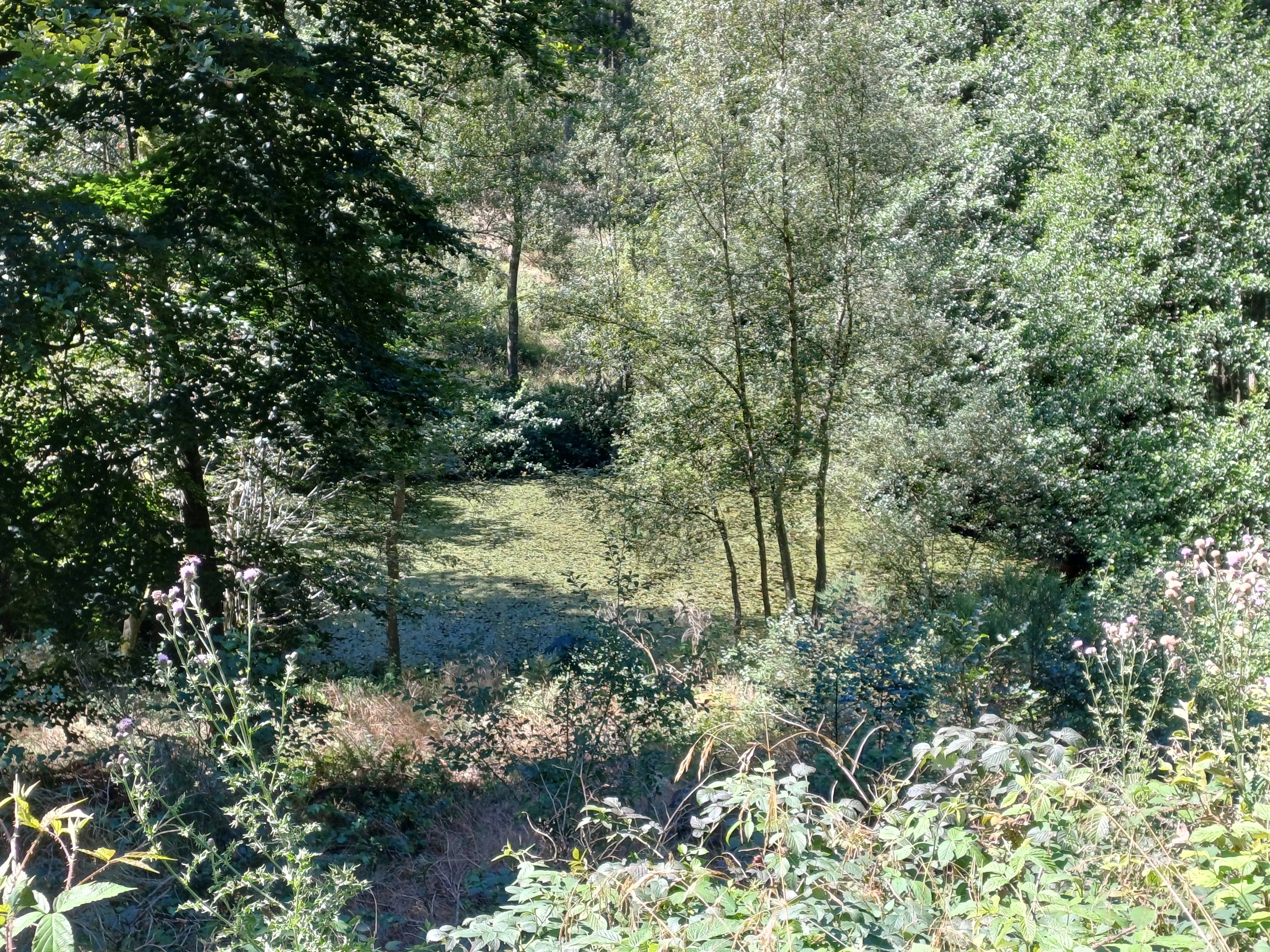
A small, tree-lined natural pond nestled within a dense forest, viewed from slightly above with foreground wildflowers and shrubs.
A small, sheltered natural pond surrounded by dense deciduous woodland in the Dürholderbachtal area.

Holderbachtal, Dürholderbachtal history and protected-area timeline

The area that would become Holderbachtal, Dürholderbachtal was protected relatively recently in formal terms, having been designated as a nature reserve in 1997. Its inclusion in the municipal landscape plan of Monschau reflects the broader effort in the late twentieth century to secure representative valley and forest habitats in the western Eifel under North Rhine-Westphalian nature conservation law.

Before designation, the landscape had already been shaped for centuries by traditional land use, including grazing of the steep, nutrient-poor slopes and small-scale management of wet meadows along the brooks. The present-day character of the reserve preserves much of this older mosaic, including abandoned and still-grazed grasslands, relic spring mires, and brook sections influenced by long-standing, sometimes ecologically problematic, fish-pond operations. Conservation management under the lower landscape authority of the Städteregion Aachen now seeks to maintain and develop these habitats, particularly those tied to running waters, wet grassland, bog woodland, and dry heath.

Holderbachtal, Dürholderbachtal landscape and geographic character

The landscape of Holderbachtal, Dürholderbachtal is defined by two gently to deeply incised stream valleys cutting through the wooded slopes east of Monschau. The Holderbach valley has a relatively open profile along its floodplain, alternating between conifer stands, mixed beech forest, and fragments of wet grassland, while the Dürholderbach valley is broader and more deeply cut, opening from a spring basin and narrowing upward toward the headwaters.

The terrain includes spring basins, small mire flats, and side siefen descending from the surrounding slopes, with shallow steps of moist and nutrient-poor grassland along the lower valley margins. The Holderbach runs over a gravel bed with visible riffles and pools, while several small artificial ponds, including a Löschwasserteich in the Dürholderbach area, add to the varied hydrological pattern of the reserve. Steep, partly grazed slopes covered with species-rich, semi-dry grassland frame the valleys and give the protected area a strongly three-dimensional, valley-bound character.

Holderbachtal, Dürholderbachtal ecosystems, habitats, and plant life

Ecologically, the reserve represents a small but unusually complete example of the habitat mosaic typical of the western Eifel stream valleys. It brings together coniferous forest, beech-dominated mixed woodland, alder swamp forest, and bog woodland on the wetter, peaty sites, alongside extensive nutrient-poor meadows, wet and dry grassland, reed beds, and spring communities higher up the slopes.

Several habitat types listed under Annex I of the EU Habitats Directive are represented within the reserve, including running waters with submerged vegetation, dry heath, humid tall herb fringe communities, Hainsimsen beech forest, and bog woodland. The combination of near-natural brooks, peat-moss-influenced spring mires, sedge communities, and Bärwurz meadows, together with alder gallery woodland along the lower Holderbach, gives the site a notably high habitat diversity for its size.

Holderbachtal, Dürholderbachtal wildlife and species highlights

The reserve has particular significance for bird species tied to near-natural, water-rich forest landscapes, including Kingfisher, Black Woodpecker, Grey-headed Woodpecker, and Nutcracker. Its clean, gravel-bedded brooks also provide habitat for the Groppe (Cottus gobio), a small bottom-dwelling fish highly sensitive to water quality.

The diverse wetland, grassland, and forest habitats support rich invertebrate communities, as indicated by the abundance of insect larvae and planarians in the Holderbach. Bog and wet woodland edges, spring mires, and abandoned meadows together provide a range of niches for amphibians, terrestrial insects, and other fauna typical of the Eifel stream valleys, even though the source material does not detail each species individually.

Holderbachtal, Dürholderbachtal conservation status and protection priorities

Holderbachtal, Dürholderbachtal was designated in 1997 as a Naturschutzgebiet under North Rhine-Westphalian nature conservation law, with the official designation code ACK-055. Its conservation aims are explicitly framed around the protection of habitats and species listed in the Red List of endangered plants, fungi, and animals of North Rhine-Westphalia, and around the maintenance and development of natural habitat types defined in Annex I of the EU Habitats Directive.

The protected biotope types targeted by the designation include wet and moist grassland, natural and near-natural water bodies, near-natural and unmodified brook sections, nutrient-poor meadows and pastures, mires, swamps, bog and swamp forests, reeds, spring areas, natural rock formations, mat-grass swards, and floodplain forests. The reserve also has documented particular importance for species such as Kingfisher, Black Woodpecker, Grey-headed Woodpecker, Nutcracker, Bogbean, and Groppe, reinforcing its role as a refuge for species that have declined across the wider regional landscape.

Top sights and standout views in Holderbachtal, Dürholderbachtal

The reserve's main highlights include the near-natural Holderbach with its gravel bed, riffles, and pools, the peat-moss-rich spring mires of the Dürholderbach valley, and the rare Bärwurz meadows on the lower slopes. Equally notable are the dense Bogbean population in the silting zone of the Dürholderbach fire-water pond and the species-rich, traditionally grazed nutrient-poor grasslands that frame both valleys.

The combination of alder swamp forest, bog woodland, humid tall herb fringe, dry heath patches, and running waters with submerged vegetation makes Holderbachtal, Dürholderbachtal a compact showcase of the habitat types the Eifel region is best known for protecting. Bird species such as Kingfisher, Black Woodpecker, Grey-headed Woodpecker, and Nutcracker underline the reserve's value as a habitat-rich valley landscape.

Best time to visit Holderbachtal, Dürholderbachtal

The reserve offers its most distinctive atmosphere in late spring and early summer, when the wet meadows, tall herb fringes, and Bärwurz-rich slopes are in full bloom and insect life along the brooks is most active. Late spring typically also brings the clearest experience of the contrast between the grazed, semi-dry grassland on the slopes and the still-saturated valley floor.

Autumn can also be rewarding, when boggy and beech forest sections take on warmer color tones and typical woodland bird activity increases. Because the site is a protected area, visitors are expected to stay on existing paths and respect the seasonal sensitivity of ground-nesting birds and amphibian breeding areas in the wetter sections.

Monthly climate preview

Long-term monthly temperature averages and precipitation patterns for Holderbachtal, Dürholderbachtal

Holderbachtal, Dürholderbachtal Climate Normals and Annual Temperature Rhythm

Historical climate data reveals the measured temperature and precipitation rhythm across twelve months at a representative coordinate in Holderbachtal, Dürholderbachtal. Reviewing the complete monthly records provides deeper analytical context for long-term environmental patterns in the protected valley.
Annual mean8 °C
0 °C17 °C
Jan
Feb
Mar
Apr
May11°
Jun15°
Jul17°
Aug17°
Sep13°
Oct
Nov
Dec
Warmest month
July

17 °C

Coolest month
January

-0 °C

Wettest month
December

3.1 mm/day

Driest month
April

1.9 mm/day

Park location guide

Geography guide, regional context, and park location map for Holderbachtal, Dürholderbachtal

Holderbachtal, Dürholderbachtal park geography, regions, and map view in Germany

Understand where Holderbachtal, Dürholderbachtal sits in Germany through a broader geographic reading of the surrounding landscape, nearby location context, and its mapped position within the national park landscape.

How Holderbachtal, Dürholderbachtal fits into Germany

Germany is a federal republic in Western and Central Europe with a population of over 83 million across sixteen constituent states. It is Europe's largest economy by nominal GDP and a major global exporter and importer. The capital is Berlin, and the country borders Denmark, Poland, Czech Republic, Austria, Switzerland, France, Luxembourg, Belgium, and the Netherlands.

Wider geography shaping Holderbachtal, Dürholderbachtal in Germany

Germany is located in Western and Central Europe, spanning 357,022 km². It borders Denmark to the north, Poland and the Czech Republic to the east, Austria and Switzerland to the south, and France, Luxembourg, Belgium, and the Netherlands to the west. The country has coastlines on the Baltic Sea and North Sea to the north, with the Alps located in the southern region.

Map view of Holderbachtal, Dürholderbachtal

Use this park location map to pinpoint Holderbachtal, Dürholderbachtal in Germany, understand its exact geographic position, and read its mapped placement within the surrounding landscape more clearly.

Pigeon | © OpenStreetMap contributors

Visual exploration of stream valleys, spring mires, and protected habitats

Holderbachtal, Dürholderbachtal Photos and Landscape Scenery

Visual documentation of Holderbachtal, Dürholderbachtal reveals the complex topography of deeply incised stream valleys, spring mires, and connected wetland habitats. Examining field photographs helps observers understand the varied terrain, woodland patches, and ecological mosaic defining the protected nature reserve.

A small, tree-lined natural pond nestled within a dense forest, viewed from slightly above with foreground wildflowers and shrubs.

Park atlas

Compare nearby Eifel stream valleys and surrounding regional protected landscapes.

Other Parks Near Holderbachtal, Dürholderbachtal and Protected Areas

Browsing other parks near Holderbachtal, Dürholderbachtal reveals connected Eifel stream valleys and protected natural reserves across the surrounding region. Comparing adjacent terrain helps trace regional habitat mosaics, wooded slopes, and spring-fed wetland networks beyond a single reserve boundary.
A soft watercolor illustration of a rolling green landscape with flowering trees and distant forested hills, isolated on a white background.
Nature reserveNordrhein-Westfalen
About 1.9 km away#1 closest

West

Kluckbachtal Nature Reserve: Geographic Atlas and Protected Stream Valley Overview

Mapped riparian forest and orchard meadow habitats in Nordrhein-Westfalen

Kluckbachtal protects a distinctive valley segment between Rohren and Höfen, featuring a complex of stream beds, wet grasslands, and old oak and alder woodland. This nature reserve is recognized for its significant role in preserving Red List species and traditional cultural landscapes, offering a detailed look at the ecology of the northern Eifel region through its varied habitats.

Area
1.13 km²
Established
1997
IUCN
IV
Relief
Upland
Watercolor illustration of rolling green hills and meadows with patches of pink and yellow flowers
National parkNorth Rhine-Westphalia
About 2 km away#2 closest

Northeast

Eifel National Park: North Rhine-Westphalia Protected Area Atlas

Explore mapped boundaries and regional geography.

Gain a structured understanding of Eifel National Park, a key protected area within Germany's North Rhine-Westphalia region. This page focuses on its geographic identity, detailing mapped boundaries and offering context within the state's broader natural landscapes. MoriAtlas enhances your exploration by presenting Eifel National Park as a distinct entity within a larger geographic framework, ideal for atlas-based research and understanding protected land distribution.

Area
107 km²
Established
2004
IUCN
II
Relief
Upland
Watercolor illustration showing a soft-focus landscape with rolling green hills, a winding stream, and hints of red floral color against a light background.
Nature reserveNordrhein-Westfalen
About 2 km away#3 closest

Southwest

Naturschutzgebiet Perlenbach-Fuhrtsbachtal: Geographic Atlas and Protected Area Context

Mapped brook valleys and rare Eifel wetland habitats

The Naturschutzgebiet Perlenbach-Fuhrtsbachtal protects a distinctive valley system near the Eifel plateau. This area is recognized for its cold, humid microclimate and diverse habitats, ranging from spring-fed fens to ancient meadow systems. Beyond its rare floral displays, the reserve serves as a critical refuge for freshwater pearl mussels and ice-age butterfly relict species, illustrating the intersection of regional geography and conservation.

Area
3.4 km²
Established
1976
IUCN
IV
Relief
Upland
A horizontal watercolor painting showing a soft, stylized landscape with rolling green hills, distant purplish ridges, and grassy foreground elements on a white background.
Nature reserveNordrhein-Westfalen
About 2.2 km away#4 closest

Northwest

Mittleres Rurtal mit den Felsbildungen der Perdsley und Wiselsley Protected Nature Reserve Map

Exploring the Rur valley river dynamics and cliff geology

Investigate the topographical features of the Mittleres Rurtal mit den Felsbildungen der Perdsley und Wiselsley, a critical nature reserve characterized by free flowing river segments and steep ravine forests. This overview outlines the ecological distribution of rock formations and riparian habitats across the Monschau region landscape.

Area
1.33 km²
Established
2003
IUCN
IV
Nature reserveNordrhein-Westfalen
About 4.4 km away#5 closest

Southeast

Wüstebachtal Nature Reserve: Protected Eifel Valley and Wetland Landscapes

Hydrological geography and upland meadow ecosystems in Nordrhein-Westfalen

Wüstebachtal represents a quintessential Eifel nature reserve where the convergence of flowing stream corridors and species-rich meadows creates a unique habitat for threatened flora. This protected area focuses on the conservation of the Wüstebach valley, maintaining vital connections between alpine-style meadow communities and forest-fringed wetlands within the North Rhine-Westphalia region.

Area
0.834 km²
Established
1997
IUCN
IV
A watercolor painting depicting a soft, panoramic landscape of a meandering stream valley with rolling hills, meadows, and scattered patches of trees.
Nature reserveNordrhein-Westfalen
About 5.4 km away#6 closest

Northwest

Kleines Laufenbachtal Nature Reserve: Geographic Atlas of an Eifel Stream Valley

Protected brook habitats and natural rock landscapes in North Rhine-Westphalia

Investigate the topographical features and habitat diversity of Kleines Laufenbachtal, an established nature reserve in the Eifel. This protected area showcases a dense assembly of wet grasslands, reed banks, and rocky slopes that anchor local ecological corridors within the Monschau landscape.

Area
0.13 km²
Established
1997
IUCN
IV
Protected landscapeBelgium
About 5.4 km away#7 closest

Southeast

Hohes Venn, Eifel Nature Park: A Protected Landscape in Belgium for Geographic Atlas Exploration

Explore mapped natural terrain and protected area details.

The Hohes Venn, Eifel Nature Park in Belgium represents a key protected landscape for atlas and geographic discovery. This entry focuses on the park's specific identity, its geographic setting within Belgium, and the value it holds for users interested in mapped terrain and protected area exploration. Understand the landscape context and the detailed geographic information available for this significant natural area, supporting structured learning about Belgium's conservation efforts.

IUCN
V
A soft watercolor illustration showing a hazy, green landscape with a winding stream, distant hills, and low-lying vegetation on a white background.
Nature reserveNordrhein-Westfalen
About 6.7 km away#8 closest

North

Kranzbach und Kranzbruchvenn: Protected Nature Reserve and Bog Landscape in Nordrhein-Westfalen

Wetland stream valleys and historic military relic landscapes

Investigate the specialized wetland ecosystems of Kranzbach und Kranzbruchvenn, a nature reserve in Nordrhein-Westfalen known for its bog and fen habitats. The site offers a detailed case study of small-stream hydrology and the transformation of former Westwall dragon teeth structures into unique marsh environments.

Area
0.328 km²
Established
2002
IUCN
IV

Common questions about visiting, size, designation, and location context for Holderbachtal, Dürholderbachtal

Holderbachtal, Dürholderbachtal FAQs for park facts, access, geography, and protected area context

Find quick answers about Holderbachtal, Dürholderbachtal, including protected-area facts, park geography, trail and visitor context, and how the park fits into its surrounding country and regional landscape.
MoriAtlas Explorer

Continue Your Protected Areas Search Across the Global Atlas

Deepen your exploration by continuing the structured search for national parks and protected areas worldwide. Utilize the comprehensive filtering capabilities to compare different conservation landscapes and refine your understanding of global park geography. Discover more about the distribution and characteristics of protected natural areas.

Global natural geography