Mori Atlas logo
Nature reserveHolmes Jungle Nature Park

Examining the dense tropical vegetation and Pine Creek catchment within a suburban wilderness corridor.

Holmes Jungle Nature Park: A Protected Monsoon Forest Refuge in Australia's Northern Territory

Holmes Jungle Nature Park represents a vital pocket of closed-canopy monsoon forest on the urban periphery of Darwin. This protected reserve safeguards a significant tropical lowland habitat where the winding Pine Creek corridor connects local terrain to the broader Shoal Bay catchment. Through its dense, layered vegetation and permanent freshwater environments, the reserve maintains a crucial wildlife refuge that remains distinct from the surrounding coastal development of the Northern Territory.

monsoon foresttropical lowlandurban nature reservecreek corridorbirdwatchingtop end habitat

Holmes Jungle Nature Park

Nature reserve

Park overview

Structured park overview, official facts, and landscape profile for Holmes Jungle Nature Park

Holmes Jungle Nature Park park facts, protected area profile, and essential visitor context

Review the core facts for Holmes Jungle Nature Park, including designation, size, terrain, visitor scale, habitats, and operating context in one park-focused overview.

About Holmes Jungle Nature Park

Holmes Jungle Nature Park is a notable example of a localised conservation reserve carved out of the rapidly developing landscape around Darwin. The park protects around 250 hectares of monsoon forest that retains the wet-season tropical character typical of the Northern Territory's Top End, while sitting immediately adjacent to the suburban fringe of the city. This juxtaposition, urban edge firmly meeting thick tropical vegetation, is one of the defining characteristics of the site and shapes much of its visitor and ecological value.

The monsoon forest community sheltered within the park is unusually dense by the standards of the surrounding area. Closed canopies, moisture-retaining understorey, and seasonal inundation support a habitat type that has otherwise become fragmented across the Darwin region. The reserve therefore functions as a refuge not just for occasional visitors but for breeding populations of birds, mammals, and reptiles that rely on intact monsoon forest patches to persist in the local landscape.

Water is central to the character of Holmes Jungle. Pine Creek winds through the park from the urban edge toward its centre, and the broader reserve links through this and other minor waterways into the Shoal Bay coastal system several kilometres to the north. Along these corridors, freshwater forest transitions into habitats that retain a strong saltwater influence, which is why saltwater crocodiles continue to be a regular, if cautious, presence. Visitors approach with that awareness, and the park has become a useful local site for experiencing tropical Top End wildlife in a setting that is both wild in feel and close to the city.

As a protected area, Holmes Jungle is a working example of the Northern Territory's commitment to conserving meaningful natural areas even as Darwin has expanded around them. Its importance is not based on sheer size or on iconic landmarks, but on the continuing presence of thick monsoon forest, flowing water, and a visible community of native wildlife in a place that residents and visitors can reach without leaving the metropolitan area.

Quick facts and research context for Holmes Jungle Nature Park

Holmes Jungle Nature Park is administered by the Parks and Wildlife Commission of the Northern Territory and has been a formally protected area since 1976. It lies within the city of Darwin, on the northern outskirts of the suburban area, surrounded by the tropical lowlands of the Northern Territory's Top End.

The park is anchored by Pine Creek, a seasonal watercourse that flows through the reserve and links it hydrologically with the wider Shoal Bay system. Saltwater crocodiles continue to use these waterways, which is one of the defining features of the site's ecological character and visitor awareness.

Protection and recognition

Explore the documented terrestrial protection scope and established designation timeline.

Holmes Jungle Nature Park Protection Status and Designation History

Holmes Jungle Nature Park maintains a recorded terrestrial protection status established in nineteen seventy-six. Structured records outline the formal conservation framework and historical designation data associated with the protected landscape.

Protection details

Protection scope
Terrestrial
Designated year
1976
Transboundary protection
No
Park context

Deeper park guide and search-rich context for Holmes Jungle Nature Park

Holmes Jungle Nature Park history, landscape, wildlife, and travel context

Explore Holmes Jungle Nature Park through its history, landscape character, ecosystems, wildlife, conservation priorities, cultural context, and seasonal travel timing in a structured park guide built for atlas discovery and search intent.

Why Holmes Jungle Nature Park stands out

Holmes Jungle Nature Park is best known for preserving a sizeable pocket of monsoon forest within close reach of central Darwin. This relatively isolated block of tropical vegetation provides habitat, breeding space, and seasonal refuge for a wide range of native animals that depend on moist, sheltered lowland forest conditions. The park is also recognised for the presence of Pine Creek and its connection to the Shoal Bay catchment, which keeps saltwater crocodiles as a constant feature of the landscape. As a result, the park is valued both as a surviving example of Top End monsoon forest and as a readily accessible wildlife site in the Darwin region.
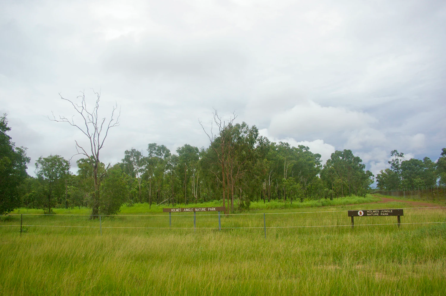
A grassy field leads to a line of trees with park identification signs visible in the middle ground under a cloudy sky.
The entrance area of Holmes Jungle Nature Park in the Northern Territory, featuring park signage and open monsoon forest habitat.

Holmes Jungle Nature Park history and protected-area timeline

The area that is now Holmes Jungle Nature Park was once referred to as Holtze Jungle, named after Maurice William Holtze, the Government Gardener who held land in the area around what is now the northern outskirts of Darwin. The Holtze name reflects the late nineteenth-century colonial era, when the Top End was being developed through gardens, agricultural experiments, and pastoral use.

The park later took the name Holmes Jungle, after Felix Holmes, a butcher who raised cattle in the same general area. The shift from Holtze to Holmes reflects the transition of the locality from government-managed agricultural land into a landscape more closely shaped by private landholders and the surrounding community.

The site was formally reserved as Holmes Jungle Nature Park on 20 January 1976, bringing the area under formal protection and placing its management with what is now the Parks and Wildlife Commission of the Northern Territory. The 1976 reservation recognised the increasing rarity of intact monsoon forest near Darwin and the need to secure a representative example of this habitat on the urban edge of the growing city.

Holmes Jungle Nature Park landscape and geographic character

The landscape of Holmes Jungle Nature Park is dominated by a closed-canopy monsoon forest that feels unexpectedly dense for a site so close to suburban Darwin. Tall trees, layered vegetation, and shaded understorey give the reserve a continuous green corridor through which Pine Creek runs toward the centre of the park.

The terrain is essentially lowland tropical, with the gentle topography of the Darwin coastal plain. There are no dramatic relief features or elevated lookouts; instead, the visual variety comes from the contrast between the dark, shaded monsoon forest interior and the more open edges where the reserve meets adjacent developed land. The creek system introduces a softer, wetter microtopography, with seasonal pools and moist banks that emphasise the tropical character of the site.

The broader landscape context is shaped by the connection to the Shoal Bay area further north. Pine Creek does not function as an isolated stream within the park; it ties into a wider network of waterways that ultimately reach tidal zones, which keeps the corridor influenced by the broader Top End coastal environment.

Holmes Jungle Nature Park ecosystems, habitats, and plant life

Holmes Jungle Nature Park's nature is defined by its monsoon forest vegetation, an ecological community that depends on the distinct wet and dry seasons of the Top End. During the wet season, the forest fills with moisture, leaf litter regeneration, and active growth, while the dry season brings a more open, quieter understorey and concentrated animal activity along the creek lines and remaining water sources.

The reserve helps maintain a humid, sheltered habitat in a region where surrounding land has been cleared for suburban development, roads, and infrastructure. This makes it valuable for species that depend on intact monsoon forest conditions, particularly those that need closed-canopy cover, fruiting trees, and damp ground for breeding, foraging, and shelter.

Ecological value also extends along the Pine Creek corridor, which links terrestrial monsoon forest habitats to the broader Shoal Bay catchment. The transition from freshwater forest to brackish and tidal influences supports overlapping ecological communities and gives the park a more layered biodiversity than purely terrestrial forest fragments of comparable size.

Holmes Jungle Nature Park wildlife and species highlights

The park supports a wide variety of native birds, mammals, and reptiles, all of which benefit from the thick vegetation cover, seasonal water availability, and relative isolation from more intensive land uses around the park boundaries. The monsoon forest interior provides breeding habitat and protection from predators, while the edges and waterways create additional foraging opportunities.

Birdlife tends to be a major draw, with the dense canopy and adjacent open spaces supporting a mix of forest-dependent species and more generalist tropical birds that move between the park and surrounding suburbs. Mammals include species typical of Top End monsoon forest and edge habitats, while reptiles thrive in the warm, sheltered conditions, particularly along the creek lines and sunlit clearings.

Saltwater crocodiles remain a defining presence in the waterways around the park. Although they are not the focus of a 'wildlife viewing' experience in the way that birds might be, their continued use of the creek corridors that connect the park to the Shoal Bay area serves as an important reminder of how intact tropical waterways in the Darwin region continue to support apex predators. The park is consistently described in local knowledge as a place where crocodiles can always be present.

Holmes Jungle Nature Park conservation status and protection priorities

Holmes Jungle Nature Park has conservation value that goes well beyond its formal protected-area designation. It is one of the remaining monsoon forest blocks within the urban footprint of Darwin, a city that has expanded steadily through the late twentieth and early twenty-first centuries. By safeguarding closed-canopy tropical vegetation and the creeklines that feed the Shoal Bay catchment, the park helps preserve ecological processes that have been heavily reduced in the surrounding landscape.

The reserve protects habitat connectivity that would be difficult to restore once lost. Pine Creek and its associated corridors continue to allow wildlife movement, seasonal flooding, and nutrient exchange between forested and more open environments. This makes the park a useful component of the broader Top End conservation network, even though it is smaller than more remote national parks in the Northern Territory.

Management of the site by the Parks and Wildlife Commission of the Northern Territory focuses on maintaining the vegetation, monitoring wildlife, and balancing public access with the safety considerations that come with living crocodiles in the waterways. The park's conservation story is closely tied to the experience of a tropical forest community persisting at the direct edge of a growing capital city.

Holmes Jungle Nature Park cultural meaning and human context

Holmes Jungle Nature Park carries a small but meaningful cultural layer tied to the colonial-era history of the Darwin area. The earlier name Holtze Jungle links the place to Maurice William Holtze, the Government Gardener who held land in the region during the late nineteenth-century development of the Top End, an important period in the early cultivation and botanical study of northern Australia.

The subsequent Holmes name connects the area to Felix Holmes, a local butcher who ran cattle in the same locale, anchoring the landscape in the practical working history of Darwin's outskirts. Combined, these naming layers make the park a small but tangible reminder of how land use, food production, and government horticulture shaped the early Darwin region, before the area was set aside as a protected reserve in 1976.

Top sights and standout views in Holmes Jungle Nature Park

Among Holmes Jungle Nature Park's strongest points of distinction is its survival as a working monsoon forest reserve on the direct urban edge of Darwin. The park is small, but its dense canopy, continuous wildlife presence, and creek-linked habitat make it stand out from more open suburban green spaces in the surrounding region.

The Pine Creek corridor is another defining highlight, both visually and ecologically, as it draws the park into the broader Shoal Bay catchment and anchors the presence of saltwater crocodiles. Together, these qualities let the reserve function as a meaningful nature experience for Darwin residents without the need to travel to large remote national parks further afield in the Northern Territory.

Best time to visit Holmes Jungle Nature Park

Holmes Jungle Nature Park is best understood through the rhythm of the Top End's tropical seasons. The wet season, typically running through the Australian summer, transforms the monsoon forest into its most lush and active phase, with thick vegetation, flowing creeks, and high wildlife movement, though heavy rainfall, humidity, and the greater presence of crocodiles in active waterways also make the conditions less comfortable for casual visits.

The dry season, from around May through September, is generally the most comfortable window for experiencing the park on foot. Lower humidity, cooler nights, and easier walking conditions make this period well suited to birdwatching, family outings, and educational visits, while the park's creeks and shaded interior still hold enough moisture to support active wildlife. Outside the wettest months, the park is most rewarding when approached with awareness of the broader Top End climate.

Monthly climate preview

Long-term representative temperature ranges and monthly precipitation rhythm

Holmes Jungle Nature Park Climate Normals and Annual Weather Patterns

Holmes Jungle Nature Park exhibits measured long-term temperature variations and monthly precipitation cycles derived from multi-year NASA coordinate sampling. Examining the complete twelve-month statistical profile provides detailed insight into historical climate normals across the protected area.
Annual mean28 °C
26 °C30 °C
Jan29°
Feb28°
Mar29°
Apr28°
May27°
Jun26°
Jul26°
Aug27°
Sep29°
Oct30°
Nov30°
Dec29°
Warmest month
November

30.1 °C

Coolest month
June

25.6 °C

Wettest month
January

12.9 mm/day

Driest month
July

0 mm/day

Park location guide

Geography guide, regional context, and park location map for Holmes Jungle Nature Park

Holmes Jungle Nature Park park geography, regions, and map view in Australia

Understand where Holmes Jungle Nature Park sits in Australia through a broader geographic reading of the surrounding landscape, nearby location context, and its mapped position within the national park landscape.

How Holmes Jungle Nature Park fits into Australia

Australia is a constitutional monarchy and federal parliamentary democracy comprising six states and ten territories. With a population of nearly 28 million, it is one of the world's most urbanised countries, with most people concentrated on the eastern seaboard. The country has a high Human Development Index and is known for its cultural diversity, ancient Aboriginal heritage, and unique wildlife.

Wider geography shaping Holmes Jungle Nature Park in Australia

Australia occupies the entire Australian continent, the island of Tasmania, and numerous smaller islands. It is the world's flattest and driest inhabited continent, featuring vast deserts in the interior (the Outback), tropical rainforests along the eastern coast, and a coastline bordering the Indian and Pacific Oceans.

Map view of Holmes Jungle Nature Park

Use this park location map to pinpoint Holmes Jungle Nature Park in Australia, understand its exact geographic position, and read its mapped placement within the surrounding landscape more clearly.

Pigeon | © OpenStreetMap contributors

Location context for Holmes Jungle Nature Park

Northern Territory

Explore protected area imagery, dense tropical vegetation, and lowland terrain features.

Holmes Jungle Nature Park Photos and Scenery: Visualizing the Monsoon Forest Landscape

Examine detailed photographs of Holmes Jungle Nature Park to understand its dense monsoon forest canopy and wetland creek corridors. Visual documentation reveals the distinct lowland terrain, shaded understories, and protected habitats defining this unique urban wilderness.

A grassy field leads to a line of trees with park identification signs visible in the middle ground under a cloudy sky.

Park atlas

Compare surrounding regional geography and connected tropical habitats

Parks Near Holmes Jungle Nature Park and Related Protected Landscapes

Browse nearby protected areas and regional reserves to compare tropical lowland habitats beyond Holmes Jungle Nature Park. Expanding the geographic scope reveals how connected waterways and monsoon forest corridors span the wider coastal plain.
A soft watercolor painting showing a pinkish lagoon surrounded by green vegetation and rolling hills in the distance.
Wildlife reserveNorthern Territory
About 3.9 km away#1 closest

South

Knuckey Lagoons Conservation Reserve: Geographic Profile and Protected Wetland Map

Tropical lagoon habitat within the Northern Territory landscape

This wildlife reserve preserves an essential tropical lagoon and wetland environment on the suburban edge of Darwin. Established in 1966, it maintains a fragment of the seasonal coastal plain character within a heavily developed corridor, serving as an important case for localized habitat management in the Northern Territory.

Area
1.25 km²
Established
1966
IUCN
IV
Relief
Lowland
National parkNorthern Territory
About 5.5 km away#2 closest

Southwest

Charles Darwin National Park: Discover its Mapped Landscape, WWII Bunkers, and Larrakia Heritage

Northern Territory protected area with significant historical and geographic context.

Charles Darwin National Park represents a distinct protected landscape in Australia's Northern Territory, offering a rich tapestry of natural beauty and historical significance. This national park is renowned for its well-preserved World War II concrete bunker complex, serving as a direct link to Australia's wartime past. Beyond its military history, the park encompasses tropical savanna woodlands and coastal terrains that provide panoramic views of Darwin Harbour. Its indigenous heritage, including ancient shell middens, highlights thousands of years of Larrakia land use, making it a layered geographic and cultural discovery point.

Area
13.03 km²
Established
1998
IUCN
II
Climate
Tropical
A watercolor painting of a serene coastal landscape with rolling green hills, trees, and soft pink clouds in the background.
Protected landscapeNorthern Territory
About 8.7 km away#3 closest

Northwest

Casuarina Coastal Reserve: Protected Landscapes and Coastal Geography in the Northern Territory

Mapped estuarine, forest, and shoreline habitats

Casuarina Coastal Reserve protects an essential strip of tropical coastline within the Northern Territory. From sandstone cliffs and Casuarina-fringed dunes to the sheltered mangrove estuaries of Buffalo Creek, the reserve provides a structured look at the complex interplay between terrestrial woodland and marine environments in an urban-edge setting.

Area
13.61 km²
Established
1978
IUCN
V
Visitors
1.1M annual
Nature reserveNorthern Territory
About 15 km away#4 closest

Southeast

Howard Springs Nature Park: Protected Landscape Maps and Regional Geography in Northern Territory

Detailed overview of tropical springs and monsoon forest terrain.

Howard Springs Nature Park offers a concentrated look at the unique Top End landscape through its permanent freshwater springs and bordering paperbark wetlands. Located near Darwin, this reserve provides essential habitat for waterfowl and serves as a primary example of protected inland spring systems within the Australian Northern Territory geography.

Area
2.86 km²
Established
1952
IUCN
V
Relief
Lowland
Wildlife reserveNorthern Territory
About 15 km away#5 closest

East

Howard Springs Hunting Reserve: Mapped Protected Landscape and Regional Geography

Wildlife reserve terrain within the Howard Sand Plains

Howard Springs Hunting Reserve is a specifically managed wildlife reserve in Australia's Northern Territory, positioned within the Howard Sand Plains. This area serves as a vital component of a larger interconnected landscape that flows from inland wetlands toward the Shoal Bay coastal environment. Providing a unique look at sustainable-use protected lands, this resource offers geographic insights into how the reserve interacts with adjacent conservation corridors in the Darwin region.

Area
16.05 km²
Established
1984
IUCN
VI
Relief
Lowland
Protected areaNorthern Territory
About 18 km away#6 closest

East

Shoal Bay Coastal Reserve Protected Landscape Mapping and Geographic Context

Coastal wetlands and eucalypt woodland in Northern Territory

Shoal Bay Coastal Reserve protects an expansive coastal fringe characterized by large tidal mud-flats and surrounding saline wetlands. This Northern Territory site offers a complex landscape where monsoon vine forests and woodland-covered uplands meet tidal substrates, providing significant habitat for migratory waterbirds.

Area
123 km²
Established
2000
IUCN
VI
Relief
Lowland
Wildlife reserveNorthern Territory
About 31 km away#7 closest

East

Black Jungle Conservation Reserve: Map, Geography, and Protected Landscape Context

Protected tropical savanna and floodplain wetlands in Northern Territory

Situated in the Northern Territory, Black Jungle Conservation Reserve preserves an essential link within the Adelaide River Coastal Floodplain. This wildlife reserve features rare spring-fed monsoon rainforests set against a backdrop of open eucalypt savanna, providing a protected sanctuary for internationally significant waterbird populations and saltwater crocodiles within a complex mosaic of tidal and seasonal wetlands.

Area
49.51 km²
Established
1986
IUCN
VI
Relief
Lowland
Wildlife reserveNorthern Territory
About 36 km away#8 closest

South

Blackmore River Conservation Reserve: Protected Riverine Geography in the Northern Territory

A tropical riparian conservation corridor near Darwin

Blackmore River Conservation Reserve features a distinct 6.5-kilometre river corridor that shelters threatened plant species within the Northern Territory. This protected area offers insight into tropical riparian ecology, showcasing the transition between lush watercourse vegetation and surrounding woodland in the Darwin hinterland.

Area
5.47 km²
Established
1984
IUCN
V
Relief
Lowland

Common questions about visiting, size, designation, and location context for Holmes Jungle Nature Park

Holmes Jungle Nature Park FAQs for park facts, access, geography, and protected area context

Find quick answers about Holmes Jungle Nature Park, including protected-area facts, park geography, trail and visitor context, and how the park fits into its surrounding country and regional landscape.
MoriAtlas Explorer

Continue Your Protected Areas Search Across the Global Atlas

Deepen your exploration by continuing the structured search for national parks and protected areas worldwide. Utilize the comprehensive filtering capabilities to compare different conservation landscapes and refine your understanding of global park geography. Discover more about the distribution and characteristics of protected natural areas.

Global natural geography