Mori Atlas logo
Protected landscapeHomochitto National Forest

Tracing the mapped boundaries and rolling terrain of this historic southern national forest.

Homochitto National Forest: A Comprehensive Geographic Analysis of Mississippi Protected Landscapes

Homochitto National Forest covers nearly 200,000 acres in southwestern Mississippi, presenting a complex mosaic of loess bluffs, forested ridges, and stream-cut valleys. This authoritative mapping resource documents the forest's development through historic reforestation and its current status as a managed protected landscape. Discover the interplay of pine woodlands and hardwood corridors that define this significant regional watershed and biodiversity sanctuary.

southern United Statesnational forestreforestationCCC heritageloess hillspine woodlands

Homochitto National Forest

Protected landscape

Park overview

Structured park overview, official facts, and landscape profile for Homochitto National Forest

Homochitto National Forest park facts, protected area profile, and essential visitor context

Review the core facts for Homochitto National Forest, including designation, size, terrain, visitor scale, habitats, and operating context in one park-focused overview.

About Homochitto National Forest

Homochitto National Forest occupies a substantial block of southwestern Mississippi, spread across the rolling country where loess-derived uplands transition toward the pine-covered landscape long associated with the American South. Covering roughly 191,839 acres across parts of seven counties, it is one of the larger National Forests in Mississippi and forms a significant continuous block of public forest land in the region.

The forest exists today largely because of a deliberate effort in the 1930s to reverse decades of agricultural decline and timber depletion. When the Civilian Conservation Corps began work here in the mid-1930s, much of the surrounding land had been worn down by repeated cotton cultivation and erosion, leaving eroded hillsides and degraded stream systems in its wake. CCC enrollees carried out extensive reforestation, laid out roads, developed early recreation areas, and helped establish the framework of administrative sites that the U.S. Forest Service still uses today.

Today, Homochitto functions as a multi-use southern national forest, managed by the U.S. Forest Service as part of the National Forests in Mississippi. It serves as habitat for a diverse plant and animal community, supports outdoor recreation, and contributes to watershed health in the Homochitto River basin. The forest's administrative presence is anchored in the regional office in Jackson, while ranger district operations are handled closer to the land in Meadville, Mississippi.

For visitors and researchers, Homochitto offers a landscape that is at once typical of the Deep South pine belt and unusual in its ecological detail. The combination of restored forest cover, loess-country terrain, perennial streams, and a surprisingly rich vascular plant flora makes it a distinctive setting within the Mississippi National Forest system.

Quick facts and research context for Homochitto National Forest

Homochitto National Forest is a 191,839-acre U.S. National Forest in southwestern Mississippi, administered by the U.S. Forest Service and headquartered, like all Mississippi national forests, in Jackson. It spans parts of Franklin, Amite, Wilkinson, Adams, Jefferson, Lincoln, and Copiah counties, with the nearest major city being Brookhaven.

Established as a national forest on July 20, 1936, Homochitto was shaped in its formative years by the Civilian Conservation Corps, which carried out planting and infrastructure work typical of New Deal-era southern forests. The forest is recognized for roughly 850 vascular plant species, at least eight freshwater mussel species in its streams, and rare winter stoneflies, including Allocapnia starki, first described from its waters.

Protection and recognition

Explore the documented terrestrial conservation scope and official designations

Homochitto National Forest Protection Status and Recognition Data

Homochitto National Forest conservation metrics detail the documented terrestrial protection status and administrative management framework. Verified records outline the baseline conservation scope for this protected woodland landscape without assuming external designations.

Protection details

Protection scope
Terrestrial
Park context

Deeper park guide and search-rich context for Homochitto National Forest

Homochitto National Forest history, landscape, wildlife, and travel context

Explore Homochitto National Forest through its history, landscape character, ecosystems, wildlife, conservation priorities, cultural context, and seasonal travel timing in a structured park guide built for atlas discovery and search intent.

Why Homochitto National Forest stands out

Homochitto National Forest is best known as one of the large southern U.S. National Forests whose modern landscape was essentially rebuilt by New Deal-era conservation work, particularly Civilian Conservation Corps reforestation during the 1930s. Its mix of loess-country terrain and southern pine forest gives it a distinctive setting within Mississippi's protected woodlands. The forest is also recognized among botanists and freshwater ecologists for its relatively rich vascular plant flora within a working forest landscape, and for the unusual presence of winter stoneflies (including a species first described from the forest) and a modest but ecologically interesting freshwater mussel fauna in its streams.

Homochitto National Forest history and protected-area timeline

Homochitto National Forest was formally established on July 20, 1936, but its modern identity was forged just before and after that date through the work of the Civilian Conservation Corps. By the mid-1930s, large portions of southwestern Mississippi had been heavily impacted by prolonged cotton farming, timber cutting, and the resulting soil erosion. The CCC mounted a substantial campaign to stabilize soils and restore forest cover, beginning what would become decades of reforestation work.

During the CCC period, workers planted trees, constructed fire infrastructure, built roads that opened up the forest for both management and public use, and developed recreation areas that would form the core of the forest's public-facing amenities. These activities gave Homochitto much of its early structure, and many of the patterns established in that era continue to influence how the forest is laid out and used today.

The forest is now administered by the U.S. Forest Service alongside Mississippi's other national forests, with its headquarters located in Jackson. Local ranger district offices in Meadville, Mississippi, carry out on-the-ground management. Over time, scientific surveys have added to the forest's significance, as botanists and aquatic biologists have documented roughly 850 vascular plant species across the forest, along with freshwater mussels and rare stoneflies that have drawn interest from conservation researchers.

Homochitto National Forest landscape and geographic character

Homochitto National Forest lies in the southwestern part of Mississippi in a region shaped by the loess belt that borders the Mississippi River valley. The terrain features rolling uplands, ridges, and stream-cut valleys typical of this transition zone, where fine wind-deposited soils give way to the sandier, flatter pine country of the Deep South interior.

The forest's drainage is tied to the Homochitto River and its tributaries, which thread through the landscape in narrow valleys bordered by mixed pine and hardwood cover. These stream corridors, combined with the higher ridges between them, create the varied topography that defines both the scenery and the ecological character of the forest.

Within the national forest boundary, the visible landscape is largely the result of reforestation and long-term forest management. Openings, regeneration blocks, and stands of different ages break up the canopy, while the network of roads laid out by the Civilian Conservation Corps and successive Forest Service administrations continues to shape how the land is experienced on the ground.

Homochitto National Forest ecosystems, habitats, and plant life

The ecological character of Homochitto National Forest centers on its mix of upland pine and hardwood forest communities set within a network of small streams and seasonal drains. The loess-influenced soils and varied topography create conditions for a wide range of plant communities across a relatively compact area.

The vascular plant flora of the forest is unusually rich for a working southern landscape, with documented totals of roughly 850 species. This botanical richness reflects the convergence of southern pine community types, hardwood-dominated stream valleys, and relict or restored plant communities associated with the historical land-use patterns of southwestern Mississippi.

Aquatic habitats within the forest, though not extensive, support important groups of organisms. The river and stream systems contribute to regional watershed health, and although bivalve diversity in these waters is described as relatively poor, the streams still host a meaningful freshwater mussel fauna alongside rare aquatic insect communities.

Homochitto National Forest wildlife and species highlights

Wildlife in Homochitto National Forest is shaped by the combination of pine-dominated uplands, hardwood stream corridors, and the mosaic of forest ages created through active management. These habitats support the typical mix of songbirds, game species, and small mammals associated with southern pine forests, while the stream valleys provide additional habitat for amphibians, reptiles, and aquatic fauna.

The forest's aquatic invertebrate communities are of particular scientific interest. At least eight species of freshwater mussels have been documented in its waters, with indications that as many as eleven may ultimately be present. Winter stoneflies are also notable, with three species collected from the forest, including Allocapnia starki, a species described as new to science from Homochitto's streams.

These invertebrate records contribute to the forest's broader ecological significance, complementing the more visible bird and mammal life and reinforcing the importance of protecting water quality and stream integrity across the landscape.

Homochitto National Forest conservation status and protection priorities

Homochitto National Forest is a notable example of recovery-driven conservation in the U.S. South. The forest's modern condition is the direct product of early efforts to halt severe soil erosion and restore forest cover on lands that had been heavily degraded by intensive agriculture and unregulated timber harvesting. The Civilian Conservation Corps reforestation campaigns of the mid-1930s established the foundation of the forest that exists today.

Beyond its reforestation history, Homochitto contributes to conservation in the region by maintaining a large block of contiguous forest cover, protecting streams and watersheds, and supporting plant and animal species of interest to scientists. The discovery of rare winter stoneflies, including a species first described from the forest, highlights the forest's role as a refuge for aquatic biodiversity in the lower Mississippi region.

As a U.S. National Forest managed by the U.S. Forest Service, Homochitto also serves as a working landscape where timber management, wildlife habitat conservation, watershed protection, and public recreation are coordinated at a regional scale through the National Forests in Mississippi framework.

Homochitto National Forest cultural meaning and human context

Homochitto National Forest's cultural identity is closely linked to the broader story of land use in the rural Deep South. The lands that would become the national forest were shaped by the agricultural cycles that dominated southwestern Mississippi for generations, including cotton cultivation that left a lasting imprint on soils, vegetation, and local communities.

The Civilian Conservation Corps era added a distinctive cultural layer to the forest. During the mid-1930s, CCC enrollees built the roads, recreation sites, and infrastructure that many visitors still encounter, linking the landscape to the broader New Deal legacy of public conservation work in the United States.

Today, the forest continues to function as a part of the working rural landscape of southwestern Mississippi, with small communities such as Meadville serving as local gateways and Brookhaven, Mississippi, acting as the nearest larger city for visitors approaching the area.

Top sights and standout views in Homochitto National Forest

Homochitto National Forest stands out as a large, working southern U.S. National Forest shaped by historic CCC reforestation and more than eight decades of subsequent management. Its combination of loess-country terrain, pine and hardwood forest communities, and intact stream networks gives it a distinctive setting within the National Forests in Mississippi.

The forest is also notable for the depth of its natural history documentation, including approximately 850 vascular plant species, a modest but real freshwater mussel fauna of at least eight species, and the presence of rare winter stoneflies such as Allocapnia starki, first described from its waters.

Best time to visit Homochitto National Forest

As a southern U.S. National Forest managed for multiple uses, Homochitto is generally accessible across the year, with character that shifts with the seasons. Spring brings active growth, flowering across the forest's unusually rich vascular plant flora, and rising wildlife activity, making it a rewarding time for botanical interest and bird observation.

Autumn offers cooler weather, fall color in the hardwood stream valleys, and traditionally comfortable conditions for hiking, driving forest roads, and visiting recreation areas developed during the CCC era. Winter is comparatively mild in southwestern Mississippi and can be a quiet, contemplative time, while summer is hot and humid, as is typical across the region, and is best approached with awareness of insects, heat exposure, and stream conditions.

Monthly climate preview

Long term temperature and precipitation records measured across representative park coordinates

Homochitto National Forest Climate Normals and Annual Weather Patterns

Homochitto National Forest experiences measured monthly temperature variations alongside steady precipitation patterns based on historical climatology data spanning from 1991 to 2020. Examining the complete twelve month climate profile reveals detailed shifts in average minimum and maximum temperatures across the protected landscape.
Annual mean19 °C
8 °C28 °C
Jan
Feb11°
Mar14°
Apr18°
May23°
Jun27°
Jul28°
Aug28°
Sep25°
Oct20°
Nov13°
Dec
Warmest month
July

28.1 °C

Coolest month
January

8.3 °C

Wettest month
January

4.9 mm/day

Driest month
September

3.2 mm/day

Park location guide

Geography guide, regional context, and park location map for Homochitto National Forest

Homochitto National Forest park geography, regions, and map view in United States of America

Understand where Homochitto National Forest sits in United States of America through a broader geographic reading of the surrounding landscape, nearby location context, and its mapped position within the national park landscape.

How Homochitto National Forest fits into United States of America

The United States of America is a federal presidential republic and one of the world's largest countries by area and population. It consists of 50 states across a vast territory spanning multiple time zones, with its capital in Washington, D.C. and largest city in New York City. The nation has a diverse economy, influential political system, and significant cultural and military presence globally.

Wider geography shaping Homochitto National Forest in United States of America

The United States occupies a vast territory in North America, bordered by Canada to the north and Mexico to the south. The 48 contiguous states stretch from the Atlantic to the Pacific Ocean, while Alaska occupies the northwestern region and Hawaii is an archipelago in the Pacific. The country encompasses diverse terrain including the Rocky Mountains, Appalachian Mountains, Great Plains, and extensive river systems.

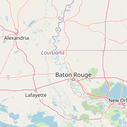
Map view of Homochitto National Forest

Use this park location map to pinpoint Homochitto National Forest in United States of America, understand its exact geographic position, and read its mapped placement within the surrounding landscape more clearly.

Pigeon | © OpenStreetMap contributors

Location context for Homochitto National Forest

Mississippi
Recorded earthquake history

Explore Historical Earthquake Records for Homochitto National Forest

Examine the recorded history of seismic activity associated with the landscapes of Homochitto National Forest. This catalogue provides direct access to historical event data including magnitudes and depths to support geographic exploration of the region's seismic patterns through MoriAtlas.

Homochitto National Forest Earthquake History

Catalogued events

1 event

Strongest magnitude

Magnitude 3

Most recent event

Aug 2, 2010

This history includes earthquakes recorded inside the park or within 50 km of its borders

Park atlas

Compare regional protected landscapes, pine woodlands, and connected river corridors.

Explore Other Parks Near Homochitto National Forest And Surrounding Protected Areas

Continue browsing national forests and protected areas located throughout the surrounding region to compare diverse southern woodland terrain. Examining adjacent conservation lands reveals broader ecological patterns across the loess hills and pine belt interior.
Wildlife reserveLouisiana
154 km away#1 closest

West

Kisatchie Hills Wilderness: Exploring Louisiana's Rugged Backcountry Protected Landscapes

Upland forest geography and preserved ridge terrain in Louisiana.

Kisatchie Hills Wilderness serves as a rare example of elevated, rugged terrain in Louisiana, offering a protected backcountry environment far removed from coastal marshes. This area provides a specialized map of forest-clad hills, ravines, and clear stream crossings that define a unique regional geography for those tracing Louisiana's diverse natural features.

Area
35.21 km²
Established
1980
IUCN
Ib
Relief
Upland
National parkLouisiana
About 176 km away#2 closest

West

Kisatchie National Forest: Geographic Overview and Protected Landscapes in Louisiana

Mapping the state's largest expanse of protected forest and pine ecosystems.

Spanning over 600,000 acres, Kisatchie National Forest stands as the primary protected natural landscape within Louisiana. Its terrain ranges from ancient upland pine formations and sandstone ridges to complex hardwood bottoms and cypress-tupelo swamps. This area serves as a vital anchor for regional biodiversity, protecting rare hillside seepage bogs and calcareous prairies that have largely vanished from the surrounding southern landscape.

Area
2,440 km²
Established
1930
Relief
Upland
Climate
Subtropical
Protected landscapeMississippi
213 km away#3 closest

Northeast

Tombigbee National Forest: Geographic Atlas and Protected Landscape Overview

Mapping the forest terrain and regional watershed in Mississippi

Tombigbee National Forest represents a complex protected landscape divided into two non-contiguous sections across northeastern Mississippi. From the pine-and-hardwood ridges of its northern unit to the reservoir-anchored southern portion, the forest offers a detailed case study in regional topography and watershed management within the southeastern United States.

Area
271.16 km²
Established
1959
Relief
Upland
Climate
Subtropical
A watercolor illustration of a coastal landscape with a sandy shoreline, soft green dunes, and a gentle pink horizon against a white background.
Protected landscapeFlorida
213 km away#4 closest

East

Gulf Islands National Seashore: Mapped Landscapes and Protected Coastal Geography

Coastal terrain across Florida, Alabama, and Mississippi.

Spanning diverse units across the Gulf Coast, Gulf Islands National Seashore preserves dynamic barrier islands and mainland reserves. This geographic profile traces the quartz-sand beaches, maritime ecosystems, and historic defense networks that form this protected landscape, providing context on its unique geologic and environmental evolution.

Area
548.179 km²
Established
1971
IUCN
V
Visitors
8.3M annual
A horizontal watercolor painting depicting a flat, green coastal marsh with distant purple hills under a pale sky.
Wildlife reserveMississippi
About 247 km away#5 closest

Southeast

Grand Bay National Estuarine Research Reserve: Mississippi Coastal Protected Area Geography

Mapping estuarine ecosystems and coastal forest mosaics

Focusing on the interface between the Mississippi Sound and terrestrial habitats, this reserve protects a vital expanse of estuarine waters, oyster reefs, and pine savanna. Its geography highlights the dynamic interaction of tidal channels, shoreline erosion, and fire-dependent ecosystems within the broader Gulf of Mexico coastal region.

Area
74 km²
Established
1999
IUCN
IV
Relief
Lowland
Watercolor painting of a green landscape featuring rolling hills, small clusters of trees, and a calm water feature in the foreground.
Protected landscapeMississippi
248 km away#6 closest

Northeast

Holly Springs National Forest: Geographic Context and Protected Landscape Boundaries

Northern Mississippi forest topography and ecological restoration geography.

Holly Springs National Forest occupies the rolling hills of north central Mississippi, where federal land tracts form a complex mosaic with private holdings. This protected area features diverse forest types including loblolly and shortleaf pine uplands alongside bottomland hardwood swamps. It serves as an essential watershed region, hosting multiple reservoirs like Chewalla Lake and Puskus Lake while protecting the headwaters of the Wolf River.

Area
629.94 km²
Established
1936
Relief
Upland
Climate
Subtropical
A pale, minimalist watercolor painting showing a soft green treeline and forest edge against a white background.
Protected landscapeTexas
363 km away#7 closest

West

Sam Houston National Forest: Mapping the Piney Woods Protected Landscape

Regional Geography of East Texas Protected Lands

Sam Houston National Forest is a 163,000-acre protected area in East Texas characterized by loblolly and shortleaf pine ridges. The geography features an intricate network of creeks, hardwood bottomlands, and designated wilderness areas like Little Lake Creek. Framed by Lake Conroe and Lake Livingston, the forest offers a complex look at Gulf Coastal Plains topography and long-standing Piney Woods ecological restoration efforts.

Area
659.82 km²
Established
1936
Relief
Lowland
Climate
Subtropical
National parkGarland County
371 km away#8 closest

Northwest

Hot Springs National Park: National Park Protected Area and Geographic Context

Mapped boundaries and regional landscape of this US National Park.

Gain a structured understanding of Hot Springs National Park, focusing on its identity as a protected national park. Examine its mapped geography and regional landscape context within Garland County, providing essential details for atlas-based exploration. This entry details the park's protected area and its position in the broader geographic framework.

Area
22.5 km²
Established
1832
IUCN
II
Visitors
2.6M annual

Common questions about visiting, size, designation, and location context for Homochitto National Forest

Homochitto National Forest FAQs for park facts, access, geography, and protected area context

Find quick answers about Homochitto National Forest, including protected-area facts, park geography, trail and visitor context, and how the park fits into its surrounding country and regional landscape.
MoriAtlas Explorer

Continue Your Protected Areas Search Across the Global Atlas

Deepen your exploration by continuing the structured search for national parks and protected areas worldwide. Utilize the comprehensive filtering capabilities to compare different conservation landscapes and refine your understanding of global park geography. Discover more about the distribution and characteristics of protected natural areas.

Global natural geography