

Mori Atlas logo
Nature reserveHorsnell Gully Conservation Park

Mapping the steep gorges, seasonal waterfalls, and rugged terrain of the Mount Lofty Ranges

Horsnell Gully Conservation Park: A Detailed Geographic Atlas of Nature Reserve Landscapes

Horsnell Gully Conservation Park serves as an essential protected area within the Mount Lofty Ranges, defined by its steep, narrow gorges that channel Third Creek toward the Adelaide Plains. This reserve showcases a transition from high-elevation stringybark woodlands to lower eucalyptus forests, providing a clear topographic gradient. Through this atlas entry, explore the mapped boundaries and natural features of this rugged site located just east of Adelaide.

Adelaide HillsMount Lofty Rangesstringybark woodlandsclerophyll forestgorgeswaterfall

Horsnell Gully Conservation Park

Nature reserve

Park overview

Structured park overview, official facts, and landscape profile for Horsnell Gully Conservation Park

Horsnell Gully Conservation Park park facts, protected area profile, and essential visitor context

Review the core facts for Horsnell Gully Conservation Park, including designation, size, terrain, visitor scale, habitats, and operating context in one park-focused overview.

About Horsnell Gully Conservation Park

Horsnell Gully Conservation Park lies in the Adelaide Hills, east of the South Australian capital and within the broader Mount Lofty Ranges. The reserve preserves a sequence of steep, narrow gorges that cut through the western face of the ranges and drain ultimately into Third Creek, one of the major tributaries of the River Torrens that flows through Adelaide. Although small in extent, the park captures a striking contrast between rugged, dissected terrain and the more open Adelaide Plains to the west.

The park's vegetation reflects the typical mosaic of the Mount Lofty Ranges, with stringybark woodland communities on the poorer, more exposed soils and smoothbark eucalyptus associations clustered on more fertile sites at lower elevations. A savannah-style understorey of introduced pasture plants with scattered shrubs was already noted in descriptions from 1980, reflecting the long history of pastoral influence across the surrounding hills. The sclerophyll character of the vegetation, with hard-leaved eucalypts and dense understorey shrubs, is a defining feature of the broader South Australian hills landscape.

Recreationally, the park is best known as the southern end of a section of the Heysen Trail, a long-distance walking route that crosses the Mount Lofty Ranges and continues south toward the Fleurieu Peninsula. Visitors also come for the small, seasonal waterfall and the network of shorter walking tracks that link the lower entrance near the Adelaide Plains to the upper slopes near Norton Summit. Interpretive and built infrastructure is modest, in keeping with the park's small size, but the trails connect it firmly to South Australia's wider walking culture.

A defining and somewhat unusual feature of Horsnell Gully is the relationship between its conservation purpose and the neighbouring quarry operation. The entire park is currently leased on a monthly basis to White Rock Quarry, owned by the German-based HeidelbergCement group, for industrial purposes. Part of the reserve is used for stockpiling and machinery storage, and water from the park's dam is drawn upon for concrete production. A community group, Residents Against White Rock Quarry, has campaigned against the continuation of this arrangement, highlighting the tensions between industrial land use and ecological protection in a reserve so close to Adelaide.

Quick facts and research context for Horsnell Gully Conservation Park

Horsnell Gully Conservation Park is a protected area of roughly 1.37 square kilometres located about 9 kilometres east of Adelaide in the Mount Lofty Ranges region of South Australia. It was first given protected status as a national pleasure resort in 1947 and has since passed through several designations, including wildlife reserve, national park, and conservation park status, before taking its present form. A section of the Heysen Trail passes through the park, linking it with broader South Australian long-distance walking infrastructure.

The park is classified as an IUCN Category III protected area, recognising it as a natural monument or feature, and it was listed on the former Register of the National Estate in 1980. The reserve adjoins Giles Conservation Park, which was separated from it in 2007, and the boundary between the two parks reflects both original land-parcel divisions and later administrative changes.

Protection and recognition

Examine the terrestrial protection scope and documented conservation status for Horsnell Gully Conservation Park.

Horsnell Gully Conservation Park Protection Status and International Recognition

Terrestrial protection records for Horsnell Gully Conservation Park establish the foundational framework for regional conservation management. Structured recognition details highlight formal protection status without assuming international framework affiliations.

Protection details

Protection scope
Terrestrial
Transboundary protection
No
Park context

Deeper park guide and search-rich context for Horsnell Gully Conservation Park

Horsnell Gully Conservation Park history, landscape, wildlife, and travel context

Explore Horsnell Gully Conservation Park through its history, landscape character, ecosystems, wildlife, conservation priorities, cultural context, and seasonal travel timing in a structured park guide built for atlas discovery and search intent.

Why Horsnell Gully Conservation Park stands out

Horsnell Gully Conservation Park is most recognised for its rugged gorges descending the western slopes of the Mount Lofty Ranges, its stringybark woodland and smoothbark eucalyptus associations, and its inclusion of a southerly section of the Heysen Trail. The park is also a notable example of a small urban-adjacent conservation area that nevertheless retains steep terrain, seasonal waterfalls, and ecologically significant sclerophyll vegetation within easy reach of central Adelaide.
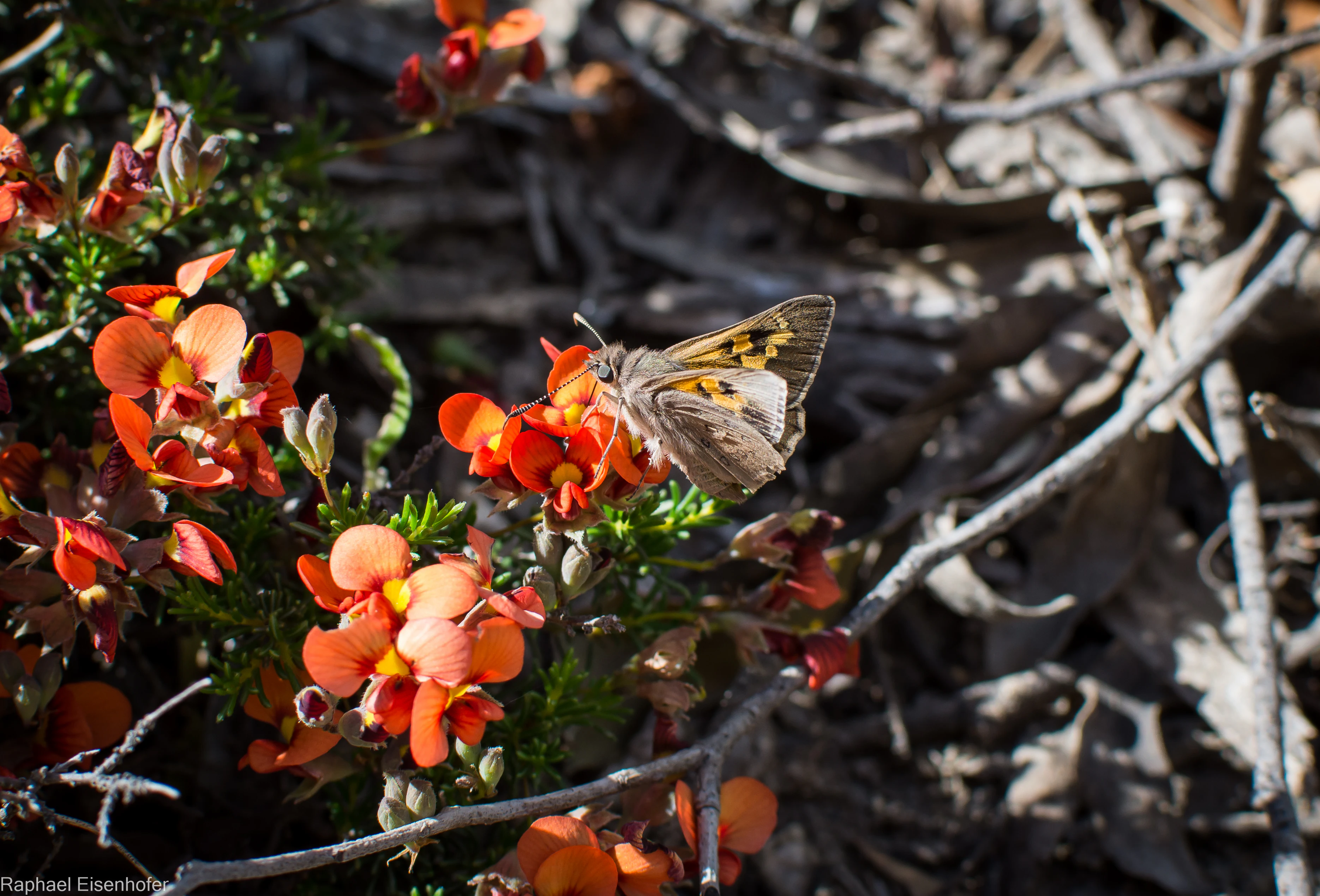
A butterfly with mottled brown and orange wings perched on a cluster of vibrant orange flowers.
A butterfly resting on native orange flowers in Horsnell Gully Conservation Park.

Horsnell Gully Conservation Park history and protected-area timeline

Horsnell Gully Conservation Park has a layered history of changing designations that mirrors the evolution of South Australia's broader protected-area framework. Land covering about 1.14 square kilometres first gained protected status as a national pleasure resort during 1947, prior to a formal dedication on 6 August 1947. In 1963, a portion of the land in section 609 was dedicated as part of a wildlife reserve under the Crown Lands Act 1929, broadening its recognised purpose from public enjoyment to broader environmental protection.

In 1967, the park was formally proclaimed under the National Parks Act 1966 as Horsnell National Park, giving it a higher formal status than its earlier wildlife-reserve and pleasure-ground designations. When South Australia consolidated its conservation framework under the National Parks and Wildlife Act 1972, the area was re-proclaimed as Horsnell Conservation Park on 27 April 1972, taking on the classification that still applies today. Additions were made in 1985 when land in sections 1118 and 1119 of the Hundred of Adelaide was incorporated, extending the park's footprint.

A further administrative change occurred on 30 August 2007, when the land added in 1985 was separated out to form the distinct Giles Conservation Park. This division reflected an attempt to clarify reserve boundaries and management responsibilities but also left Horsnell Gully Conservation Park as the smaller of the two resulting reserves. In 1980 the park was described in detail in a survey of South Australian reserves, and in the same year it was entered on the Register of the National Estate, recognising its heritage and ecological values at a national level.

In more recent decades, the park's history has been shaped by the emergence of its lease arrangement with White Rock Quarry and the associated community opposition. The residents' group campaigning for the termination of the lease has become a recurring feature of local environmental politics in the Adelaide Hills, framing the park as both a functioning conservation area and a contested industrial land-use case study.

Horsnell Gully Conservation Park landscape and geographic character

The landscape of Horsnell Gully Conservation Park is dominated by the steep western face of the Mount Lofty Ranges and the network of small gorges that descend toward the Adelaide Plains. These gorges channel runoff westward into Third Creek, ultimately contributing to the flow of the River Torrens through Adelaide. The terrain is rugged for the park's modest area, with narrow valleys, ridgelines, and slopes that fall sharply from the upper ranges to the lower entrance.

A key visual feature is a small seasonal waterfall accessible from the walking tracks. Its flow depends on seasonal rainfall in the Mount Lofty Ranges, and during drier periods the fall may reduce to a trickle or disappear entirely. The presence of the fall, combined with the steep gorges and exposed rock, gives the park a defined scenic character despite its small size.

At the upper end of the park, the landscape transitions into the broader hills environment near Norton Summit, with higher elevations, broader ridgelines, and views back toward the Adelaide Plains and the coast. At the lower end, near the park's main entrance, the terrain eases into the flatter country associated with the Adelaide Plains, providing a clear gradient of landforms within a very short walking distance. This contrast between gorge and plain is one of the most distinctive aspects of the park's physical setting.
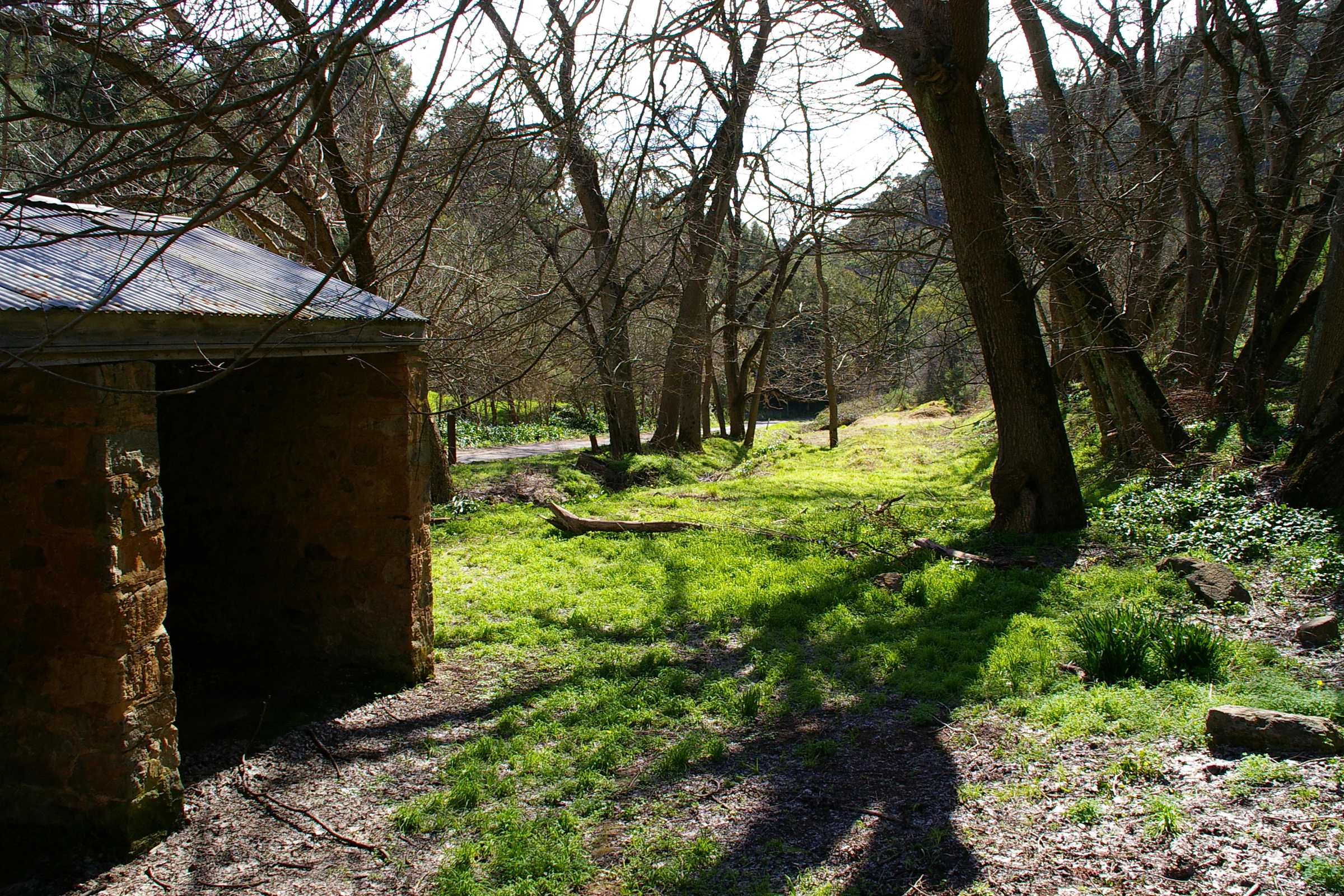
A rustic stone building with a dark opening stands in a wooded, grassy area, with trees casting long shadows on the ground.
A stone structure at the entrance of Horsnell Gully Conservation Park.

Horsnell Gully Conservation Park ecosystems, habitats, and plant life

The vegetation of Horsnell Gully Conservation Park reflects the typical sclerophyll woodlands of the Mount Lofty Ranges. The dominant plant communities are stringybark associations on the poorer, upper-slope soils, with sclerophyllous understoreys of hard-leaved shrubs. On more fertile soils at lower elevations, smoothbark eucalyptus associations take over, including river red gum, manna gum, and South Australian blue gum. Together, these associations form a mosaic that is characteristic of the Adelaide Hills but is increasingly rare in intact form closer to Adelaide.

A noticeable feature of the vegetation pattern is a savannah-style understorey of introduced pasture plants with occasional shrubs, noted already in the 1980 description of the park. This mix of native canopy and introduced ground layer reflects the long history of grazing and rural land use across the surrounding hills and the gradual infiltration of pasture species from cleared neighbouring land. The stringybark canopy itself remains the most ecologically significant feature, as stringybark woodlands of this kind provide habitat for a wide range of native fauna and are a defining vegetation type of the region.

The park's protected status, though small in area, gives it a role in maintaining connectivity between other remaining patches of native vegetation in the Mount Lofty Ranges, particularly through its connection to Giles Conservation Park and to other nearby reserves along the Heysen Trail corridor. As such, its ecological value extends beyond its individual footprint into the broader Adelaide Hills landscape.

Horsnell Gully Conservation Park wildlife and species highlights

Although the park's small size limits its capacity to support large or rare species, the stringybark and smoothbark eucalyptus communities provide habitat for a range of typical Mount Lofty Ranges birds, reptiles, and insects. Walking tracks through the park regularly pass flowering native and introduced plants that attract butterflies and other pollinators, and observers have noted orthopterans, butterflies, and a variety of small insect life along the trails. These invertebrates form an important part of the sclerophyll ecosystem and respond to seasonal flowering pulses in the understorey.

The park's position along the Heysen Trail corridor also means it contributes to landscape-scale habitat continuity for species that move through the Mount Lofty Ranges. Reptiles typical of rocky gorge environments in the Adelaide Hills, such as skinks and small dragons, find shelter among the granite boulders and leaf litter along the creek lines. Birdlife in the canopy includes honeyeaters, parrots, and other species typical of stringybark woodland, although the relatively narrow reserve and surrounding land-use pressures may limit overall diversity compared with larger Mount Lofty Ranges parks.

Horsnell Gully Conservation Park conservation status and protection priorities

Horsnell Gully Conservation Park's principal conservation significance lies in its role as a small but ecologically representative patch of Mount Lofty Ranges woodland close to Adelaide. Within the broader regional context, where much of the original stringybark and smoothbark vegetation has been cleared for agriculture, urban development, or industrial purposes, the park preserves sclerophyll communities and contributes to landscape connectivity through its position along the Heysen Trail corridor.

The park's formal recognition has included its classification as an IUCN Category III protected area, focused on natural monuments or features, and its 1980 inclusion on the Register of the National Estate, acknowledging its heritage and ecological values at a national level. These designations highlight the park's standing as a recognised component of Australia's protected-area network, despite its very small area.

However, the park's conservation status is complicated by its ongoing lease to White Rock Quarry, under which parts of the reserve have been used for stockpiling, machinery storage, and water extraction from its dam for concrete production. Resident concerns about this arrangement have raised broader questions about the management balance between preserving ecological values in a small urban-adjacent reserve and accommodating long-standing industrial activities neighbouring the park. The tension between conservation goals and industrial use has become a defining feature of the park's contemporary conservation profile.

Horsnell Gully Conservation Park cultural meaning and human context

Horsnell Gully Conservation Park sits within the broader cultural landscape of the Adelaide Hills, an area historically shaped by orchards, pasture, stone quarrying, and walking trails. The neighbouring White Rock Quarry reflects the long tradition of stone extraction that supplied building material to Adelaide, and the quarrying industry's footprint in the hills is part of the regional cultural identity. The presence of a leased conservation park adjacent to such infrastructure provides a tangible example of how industrial and conservation land uses intersect in the Adelaide Hills.

The park also plays a role in South Australian walking culture through its inclusion of a section of the Heysen Trail, named after the painter Hans Heysen and recognised as one of Australia's great long-distance walks. The trail brings thousands of walkers through the park each year and ties Horsnell Gully into a wider network of cultural and recreational routes running from the Adelaide Hills to the Fleurieu Peninsula. Community engagement around the park, including the residents' campaign against the quarry lease, also reflects the strong local attachment to the hills as a place of recreation, identity, and environmental concern in metropolitan Adelaide.

Top sights and standout views in Horsnell Gully Conservation Park

Horsnell Gully Conservation Park packs a striking concentration of features into a very small footprint: steep gorges draining into Third Creek, a seasonal waterfall, stringybark woodland on the upper slopes, smoothbark eucalyptus associations below, and a section of the Heysen Trail linking it to South Australia's broader walking infrastructure. Its proximity to central Adelaide, around 9 kilometres east of the city centre, makes it one of the closest places to the South Australian capital where visitors can experience the rugged terrain and sclerophyll woodland of the Mount Lofty Ranges.

Equally distinctive is the park's unusual modern context: a small urban-adjacent reserve whose land is leased for industrial quarrying purposes. This combination of recreational, ecological, and industrial elements shapes both the park's identity and the ongoing debates about how such small reserves should be managed in a region where urban and industrial pressures are intense.

Best time to visit Horsnell Gully Conservation Park

The park's seasonal character is shaped primarily by rainfall in the Mount Lofty Ranges, which feeds the seasonal waterfall and supports the understorey vegetation. Cooler months between late autumn and early spring typically bring the strongest flow in the creeks and the most reliable waterfall display, and are also the most comfortable time for the steep walking tracks. Spring is particularly rewarding for wildflowers along the trails, and the flowering Allium species photographed on the Horsnell Gully walk illustrates the kind of seasonal interest the park offers during this period.

Summer in the Adelaide Hills can be hot and dry, with reduced water flow and higher fire risk, making longer walks more demanding and less scenically rewarding in the gorges. Autumn tends to be mild and offers more stable walking conditions, with softer light across the slopes and reduced heat stress. Winter can bring cool, wet conditions, but the gorges and seasonal waterfall are at their most active, making the cooler months broadly the most appealing period for visitors interested in the park's water features and broader scenic character.

Monthly climate preview

Examine long-term representative temperature ranges and monthly precipitation averages for South Australia.

Horsnell Gully Conservation Park Climate Normals and Annual Weather Patterns

Historical NASA Power climatology data spanning 1991 to 2020 reveals the measured monthly temperature and precipitation rhythm recorded at a representative coordinate within Horsnell Gully Conservation Park. Accessing the complete twelve-month profile provides a detailed breakdown of average maximums, minimums, and precipitation normals across the year.
Annual mean16 °C
10 °C22 °C
Jan22°
Feb22°
Mar20°
Apr16°
May13°
Jun11°
Jul10°
Aug10°
Sep12°
Oct15°
Nov18°
Dec20°
Warmest month
January

22.1 °C

Coolest month
July

9.8 °C

Wettest month
June

2.2 mm/day

Driest month
January

0.5 mm/day

Park location guide

Geography guide, regional context, and park location map for Horsnell Gully Conservation Park

Horsnell Gully Conservation Park park geography, regions, and map view in Australia

Understand where Horsnell Gully Conservation Park sits in Australia through a broader geographic reading of the surrounding landscape, nearby location context, and its mapped position within the national park landscape.

How Horsnell Gully Conservation Park fits into Australia

Australia is a constitutional monarchy and federal parliamentary democracy comprising six states and ten territories. With a population of nearly 28 million, it is one of the world's most urbanised countries, with most people concentrated on the eastern seaboard. The country has a high Human Development Index and is known for its cultural diversity, ancient Aboriginal heritage, and unique wildlife.

Wider geography shaping Horsnell Gully Conservation Park in Australia

Australia occupies the entire Australian continent, the island of Tasmania, and numerous smaller islands. It is the world's flattest and driest inhabited continent, featuring vast deserts in the interior (the Outback), tropical rainforests along the eastern coast, and a coastline bordering the Indian and Pacific Oceans.

Map view of Horsnell Gully Conservation Park

Use this park location map to pinpoint Horsnell Gully Conservation Park in Australia, understand its exact geographic position, and read its mapped placement within the surrounding landscape more clearly.

Pigeon | © OpenStreetMap contributors

Location context for Horsnell Gully Conservation Park

South Australia

Visual exploration of Adelaide Hills terrain, stringybark woodlands, and protected park scenery

Horsnell Gully Conservation Park Photos, Rugged Gorges, and Scenic Landscape Views

Visual records capture the steep western slopes of the Mount Lofty Ranges, narrow gorges, and stringybark woodland habitats defining Horsnell Gully Conservation Park. Photographic documentation reveals the distinct terrain gradients and seasonal watercourses characterizing this protected reserve.

A butterfly with mottled brown and orange wings perched on a cluster of vibrant orange flowers.

A close-up of a weathered wooden fence post surrounded by a patch of small white flowers, with a blurred trail winding into a forest in the background.

A rustic stone building with a dark opening stands in a wooded, grassy area, with trees casting long shadows on the ground.

Park atlas

Compare regional protected areas and connected terrain across the Mount Lofty Ranges

Other Parks Near Horsnell Gully Conservation Park and Surrounding Protected Landscapes

Visitors exploring Horsnell Gully Conservation Park can examine nearby protected areas and connected regional terrain across the Mount Lofty Ranges. Comparing adjacent reserves reveals broader patterns in sclerophyll woodland, rugged gorge topography, and metropolitan conservation boundaries.
Nature reserveSouth Australia
About 0.8 km away#1 closest

East

Giles Conservation Park: Protected Nature Reserve and Adelaide Hills Geography Map

Exploring native woodland terrain and regional trail corridors

Giles Conservation Park protects a significant pocket of remnant eucalypt woodland within the Adelaide Hills of South Australia. Located near Norton Summit, the reserve preserves native habitats that support western grey kangaroos and koalas while providing a key segment for the Heysen and Yurrebilla long distance walking trails. This landscape is a fundamental part of the foothills ecosystem and a notable feature in local topographic study.

Area
1.09 km²
Established
2007
IUCN
III
Water
Minor water
National parkAdelaide Hills
About 3.9 km away#2 closest

South

Cleland National Park: Mapped Protected Landscape and Regional Geographic Context

Discover the natural terrain and park boundaries within Adelaide Hills.

Cleland National Park offers a critical lens into the protected landscapes of South Australia's Adelaide Hills. As a national park, its mapped boundaries and geographic position are key elements for understanding regional natural terrain. This resource facilitates atlas-style exploration of Cleland National Park, highlighting its importance within the conservation framework and providing a foundation for detailed geographic study.

Area
11.25 km²
Established
1945
IUCN
II
Visitors
100K annual
Protected landscapeSouth Australia
About 5 km away#3 closest

North

Black Hill Conservation Park: Mount Lofty Ranges Protected Area and Regional Geography

Bushland ridge lines and trail networks near Adelaide

Examine the geography of Black Hill Conservation Park, a significant protected landscape defined by its steep ridges and 467-metre summit. This area serves as a key bushland anchor in the Mount Lofty Ranges, featuring complex trail systems and specialized heathland habitats. Gain insights into the natural terrain, regional connectivity, and protected boundary characteristics of this essential conservation zone in South Australia.

Area
7.58 km²
Established
1972
IUCN
III
Relief
Mountain
National parkSouth Australia
About 8.5 km away#4 closest

Southwest

Belair National Park National Park: South Australia Protected Landscape and Map Exploration

Explore the geographic context and mapped boundaries of this South Australian protected area.

Belair National Park represents a significant protected land entity within South Australia, offering specific geographic insights relevant to atlas exploration. As a designated national park, its mapped boundaries and landscape character are essential for understanding regional conservation efforts. This profile provides foundational information on the park's identity as a protected natural area, anchoring its position within the geography of South Australia for detailed map-based discovery and regional context.

Area
8.35 km²
Established
1891
IUCN
II
Visitors
358.6K annual
Nature reserveSouth Australia
About 16 km away#5 closest

Northeast

Cudlee Creek Conservation Park: Geography, Protected Boundaries, and South Australian Terrain

Adelaide Hills nature reserve with riparian forest and eucalypt woodland habitat

Cudlee Creek Conservation Park provides a clear look at the Adelaide Hills landscape through its mix of steep stringybark forest and River Torrens riparian habitat. This small nature reserve serves as an important regional reference site for native plant communities and bird habitat within the context of a heavily altered agricultural landscape in South Australia.

Area
0.49 km²
Established
1971
IUCN
III
Relief
Upland
National parkSouth Australia
About 18 km away#6 closest

Southwest

Glenthorne National Park, Ityamaiitpinna Yarta: Exploring South Australia's National Park Geography

Understand the park's protected landscape and mapped context.

Glenthorne National Park, Ityamaiitpinna Yarta represents a key protected area within South Australia, offering focused insights into its geographic placement and landscape characteristics. As a national park, it serves as an important entity for understanding regional natural landscapes and the mapped distribution of protected lands across the state. Explore its specific context within South Australia's broader geography.

Established
2020
Scope
Terrestrial
Water
Minor water
Nature reserveSouth Australia
About 23 km away#7 closest

East

Charleston Conservation Park: Geography and Woodland Transitions in the Adelaide Hills

Explore protected terrain in South Australia

Charleston Conservation Park stands as an important ecological remnant in the Adelaide Hills. Its 54 hectares offer a concentrated look at woodland associations ranging from sheoak groves to blue gum forest and silver banksia stands. Use this atlas resource to understand the park's topography, its role in the Mount Lofty Ranges, and its contribution to regional conservation efforts.

Area
0.54 km²
Established
1976
IUCN
III
Relief
Upland
National parkSouth Australia
About 24 km away#8 closest

Southwest

Onkaparinga River National Park: National Park Protected Landscape in South Australia

Explore mapped boundaries and regional geographic context.

Onkaparinga River National Park is a designated national park within South Australia, offering a focused point for understanding protected landscapes. This entry provides detailed geographic context, highlighting the park's mapped boundaries and its place within the regional atlas. Engage with the specific geography and protected-area identity of Onkaparinga River National Park to enhance your landscape exploration.

Area
15.42 km²
Established
1993
IUCN
II
Relief
Upland

Common questions about visiting, size, designation, and location context for Horsnell Gully Conservation Park

Horsnell Gully Conservation Park FAQs for park facts, access, geography, and protected area context

Find quick answers about Horsnell Gully Conservation Park, including protected-area facts, park geography, trail and visitor context, and how the park fits into its surrounding country and regional landscape.
MoriAtlas Explorer

Continue Your Protected Areas Search Across the Global Atlas

Deepen your exploration by continuing the structured search for national parks and protected areas worldwide. Utilize the comprehensive filtering capabilities to compare different conservation landscapes and refine your understanding of global park geography. Discover more about the distribution and characteristics of protected natural areas.

Global natural geography