
Mori Atlas logo
Nature reserveHoscheider Venn mit Quellgebieten des Dreiläger- und Schleebaches

A rare fragment of the Venn high moor and glacial landscape in the western Eifel borderlands

Hoscheider Venn mit Quellgebieten des Dreiläger- und Schleebaches Protected Nature Reserve Landscapes

Discover the geographic composition of Hoscheider Venn mit Quellgebieten des Dreiläger- und Schleebaches, a significant nature reserve in the Roetgen municipality of Nordrhein-Westfalen. This protected area preserves a complex mosaic of raised bog communities, wet heathlands, and centuries old oak-birch forests. The terrain features unique relict pingos and natural spring catchments that feed the Dreiläger and Schleebach streams, offering an essential reference for wetland ecology.

bograised bogmoorwet heathpeatlandpingo
A digital illustration of a peaceful mountain landscape featuring a winding river, tall coniferous trees, ferns, tall grass, and a waterfall flowing from rocky cliffs under a setting sun.

Hoscheider Venn mit Quellgebieten des Dreiläger- und Schleebaches

Nature reserve

Park overview

Structured park overview, official facts, and landscape profile for Hoscheider Venn mit Quellgebieten des Dreiläger- und Schleebaches

Hoscheider Venn mit Quellgebieten des Dreiläger- und Schleebaches park facts, protected area profile, and essential visitor context

Review the core facts for Hoscheider Venn mit Quellgebieten des Dreiläger- und Schleebaches, including designation, size, terrain, visitor scale, habitats, and operating context in one park-focused overview.

About Hoscheider Venn mit Quellgebieten des Dreiläger- und Schleebaches

Hoscheider Venn mit Quellgebieten des Dreiläger- und Schleebaches is a compact but ecologically dense nature reserve occupying 196 hectares in the Roetgen/Lammersdorf exclave of North Rhine-Westphalia. Geographically, the exclave sits embedded within the Belgian borderlands, immediately adjacent to the Hohes Venn, the largest contiguous raised bog complex in the Eifel region. This location explains much of the reserve's ecological character: it functions as a transitional and protective buffer on the western edge of the Hohes Venn's German share, preserving habitats otherwise heavily reduced or lost across much of the surrounding landscape.

The reserve comprises several habitat complexes of distinct conservation interest. The most prominent is the Wollerscheider and Hoscheider Venn core, a fragmented mosaic of wet heath, raised bog remnants, and relict pingos, dome-shaped periglacial mounds whose basins hold extremely nutrient-poor water and support classic ombrotrophic bog vegetation. Cottongrass mats, Sphagnum cushions, and dwarf shrub heaths with crowberry and bog cranberry dominate these surfaces, while slightly elevated ridges expose drier communities such as moorgrass-sedge vegetation with broom heath and mat grass. Surrounding the bog core, a series of regeneration areas is being actively restored, with drained ditches dammed, spruce encroachment removed, and former forest clearings left to undergo natural succession toward birch and bog pine woodlands.

East of the Venn core, the protected area extends to include a moss-and-heath regeneration zone between the Hoscheider and Wollscheider areas, an ancient oak and birch forest east of Roetgen along the Bundesstraße 258, and the spring headwaters of the Dreiläger Bach and Schleebach. These northern and southern forest zones display multi-stemmed oaks evolving from historical coppice, bracken-dominated herb layers, scattered alder patches within spruce plantations, and small reddish-colored spring runs. The entire system is recognized as an irreplaceable reservoir for habitats listed under the EU Habitats Directive, particularly bog woodlands, wet heath with common heather, and transition mires with quaking bog communities, and it functions as a key reference site for mire conservation in the western German uplands.

Quick facts and research context for Hoscheider Venn mit Quellgebieten des Dreiläger- und Schleebaches

Hoscheider Venn mit Quellgebieten des Dreiläger- und Schleebaches is a nature reserve (Naturschutzgebiet) in North Rhine-Westphalia, Germany, established in 1982 and administered under the Landschaftsplan Roetgen framework. Its site code is ACK-009, and it is recorded in the World Database on Protected Areas under WDPA-ID 344688. The reserve covers 196 hectares within the Roetgen/Lammersdorf exclave and is classified as IUCN Category IV (Habitat/Species Management Area).

The reserve protects three Annex I habitat types of the EU Habitats Directive: bog woodlands, wet heathlands with common heather (Glockenheide), and transition mires and quaking bogs. Biotope types present include wet and moist grassland, mires, swamps, moor and swamp forest, dwarf shrub heath, and natural springs that give rise to the Dreiläger Bach and Schleebach streams.

Protection and recognition

Explore documented terrestrial protection metrics and official registry records.

Protection Status and International Recognition for Hoscheider Venn mit Quellgebieten des Dreiläger- und Schleebaches

Terrestrial protection metrics for Hoscheider Venn mit Quellgebieten des Dreiläger- und Schleebaches outline the documented conservation scope and registry data. Official records catalogued under WDPA provide structured reference values for ongoing regional management tracking.

Protection details

Protection scope
Terrestrial
WDPA ID
344688
Park context

Deeper park guide and search-rich context for Hoscheider Venn mit Quellgebieten des Dreiläger- und Schleebaches

Hoscheider Venn mit Quellgebieten des Dreiläger- und Schleebaches history, landscape, wildlife, and travel context

Explore Hoscheider Venn mit Quellgebieten des Dreiläger- und Schleebaches through its history, landscape character, ecosystems, wildlife, conservation priorities, cultural context, and seasonal travel timing in a structured park guide built for atlas discovery and search intent.

Why Hoscheider Venn mit Quellgebieten des Dreiläger- und Schleebaches stands out

Hoscheider Venn is best known for preserving a rare, intact fragment of the Venn high-moor landscape, with extensive raised bog communities, relict pingos, and wet heath vegetation typical of the larger Hohes Venn to the west. The reserve is also notable for the combined ecological value of its bog-heath complexes, regenerating dome-shaped spring mires fed by extremely nutrient-poor water, and surrounding acidophilous oak-birch forests with old-growth characteristics. Its floristic significance, including populations of round-leaved sundew, bog asphodel, deergrass, and bog cotton, establishes it as an important reference site for conservation biology in the western Eifel border region.
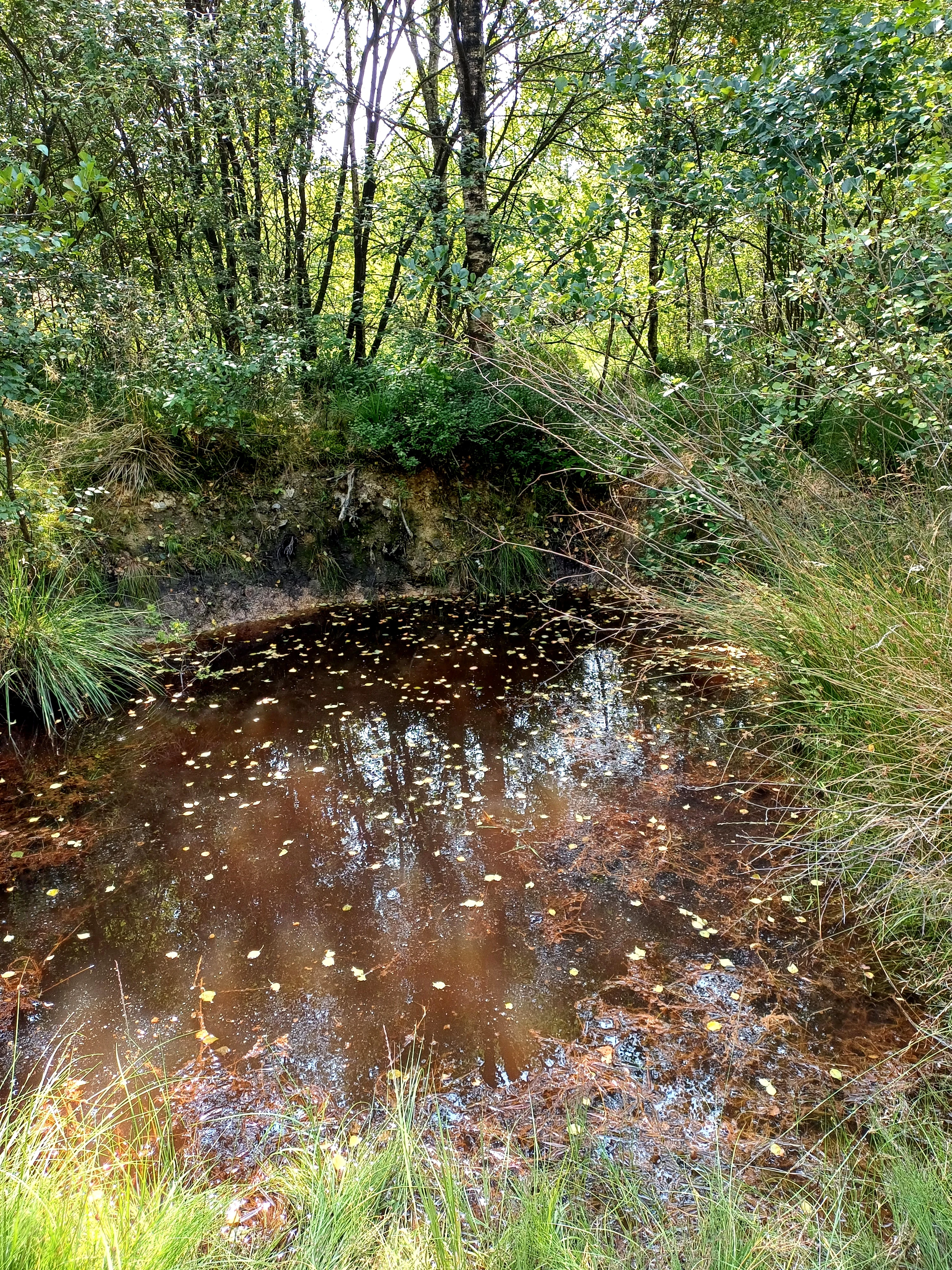
A small, dark circular pond with tea-colored water sits nestled within a forest, framed by tall grasses, low vegetation, and dense trees.
A small, dark peat pond surrounded by lush forest vegetation within the Hoscheider Venn nature reserve.

Hoscheider Venn mit Quellgebieten des Dreiläger- und Schleebaches history and protected-area timeline

Hoscheider Venn mit Quellgebieten des Dreiläger- und Schleebaches was formally designated as a nature reserve in 1982 under the framework of the Landschaftsplan Roetgen. Its establishment reflected growing awareness of the ecological deterioration of the Venn landscape, where centuries of drainage, peat cutting, afforestation with non-native spruce, and windthrow damage had converted much of the original raised bog forest into degraded secondary woodland and open heath.

Since the 1980s, the reserve has been subject to active management interventions supervised by the lower landscape authority of the Städteregion Aachen. Restoration efforts have included the removal of encroaching spruce stands, particularly in the Hoscheider Venn core where mature spruce plantations had colonized former bog surfaces, the closure and backing up of historical drainage ditches to encourage rewetting, and the deliberate cessation of forestry use along certain forest paths to encourage pioneer bog vegetation such as round-fruited rush and English broom. The historical presence of two relict, filled-in pingos has also shaped the focus of restoration: their basins are treated as priority targets for establishing and expanding characteristic bog communities, given their existing populations of moorgrass, bog heather, bog cotton, common sundew, and white beak-sedge. Across the reserve, restoration continues to focus on extending the existing Venn nature reserves by increasing wetness and reducing shrub encroachment, restoring the protected ecological character the area possessed before extensive 20th-century land use changes.

Hoscheider Venn mit Quellgebieten des Dreiläger- und Schleebaches landscape and geographic character

The landscape of Hoscheider Venn is shaped by its position on the western edge of the Eifel uplands, immediately adjacent to the border with Belgium and the broader Hohes Venn moorland. The terrain reflects the erosional and depositional history of a formerly glaciated high plateau: gently rounded ridges, shallow basins, and a series of circular relict pingos, dome-shaped mounds created by frost processes during the last glacial period that today hold small, water-filled depressions.

The vegetation mosaic closely tracks this topographic variation. On the slightly elevated and better-drained ridges, dry heath communities with broom heath and mat grass prevail; the broad, flat valleys and the filled basins of the pingos support raised bog complexes with Sphagnum cushions, cottongrass swards, and dwarf shrub heaths featuring heather and crowberry. Springs with reddish, iron-rich water emerge at the edges of the reserve, feeding the Dreiläger Bach and Schleebach, which cut shallow valleys through the surrounding forests. The forest sections of the reserve are gently sloped, with mixed stands of century-old pedunculate oak, birch, and encroaching spruce, while cleared former forest areas present open landscapes of moorgrass and heather colonized by young birch and spruce regeneration.

Together these features create a varied but coherent post-glacial upland landscape, a patchwork of bog hollows, heath ridges, ancient wood pastures, and small spring brooks that characterizes the rare surviving Venn landscape in northwest Germany.
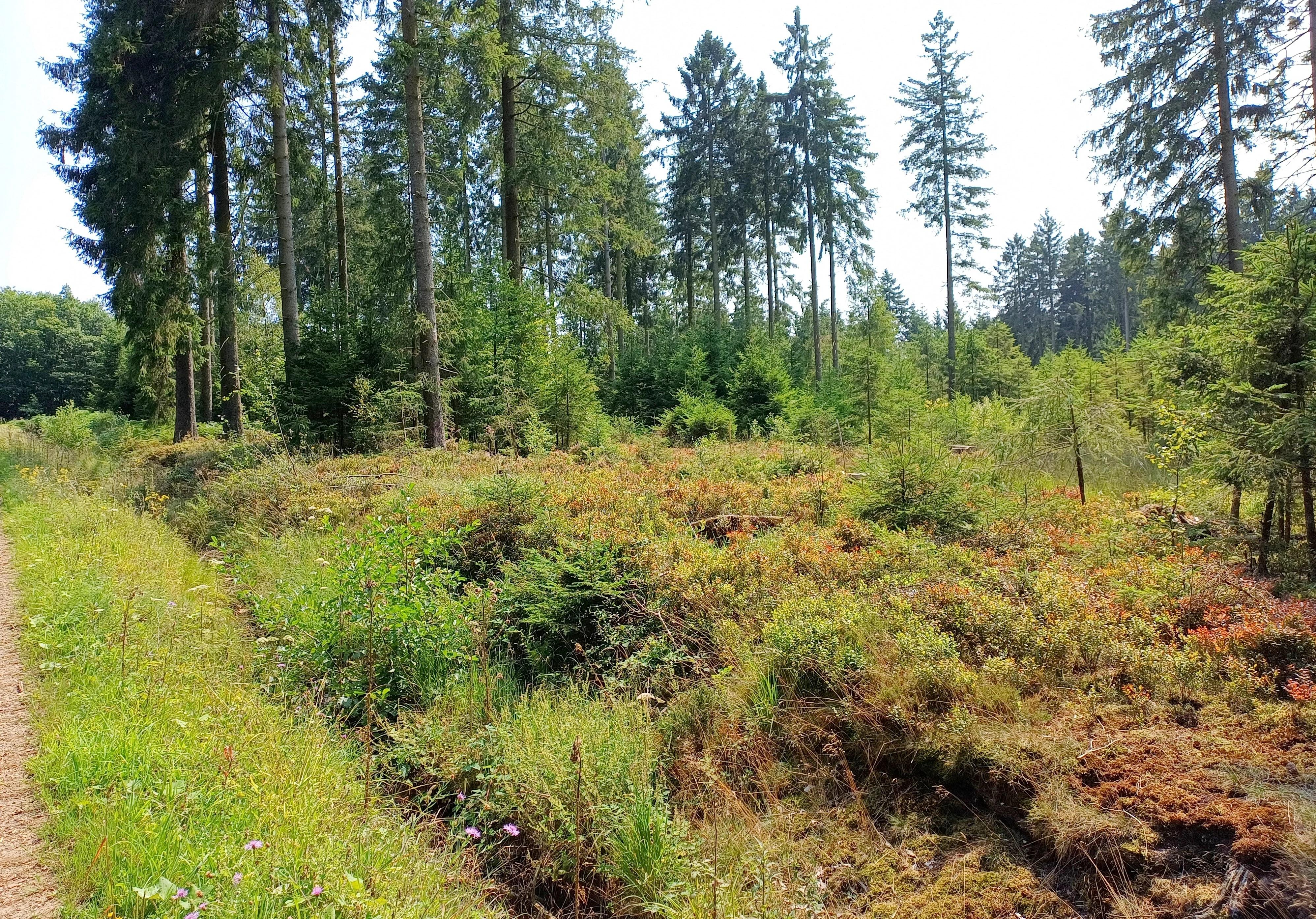
A wide outdoor shot of the Hoscheider Venn wetland area in Germany, featuring low-lying bog vegetation in the foreground and a dense line of coniferous trees in the background.
A view of the wetland and forest landscape in the Hoscheider Venn nature reserve.

Hoscheider Venn mit Quellgebieten des Dreiläger- und Schleebaches ecosystems, habitats, and plant life

Hoscheider Venn encompasses a particularly rich range of bog and heath habitats that together capture the essence of the broader Hohes Venn ecosystem. The most ecologically distinctive habitats are the ombrotrophic raised bog communities and the transition mires occupying the filled pingos: their peat surfaces consist largely of Sphagnum mats supporting narrow-leaved cottongrass, bog asphodel, white beak-sedge, bog cranberry, and, locally, round-leaved sundew, an insectivorous species highly dependent on the very low nutrient status of bog water. Aligned along the slightly elevated bog margins are wet heaths dominated by common heather (Glockenheide) but enriched by other dwarf shrubs such as bog bilberry (Rauschbeere) and the broader cushion-peat communities.

Away from the open moor, the reserve includes extensive wet heath communities with moorgrass and mat grass, together with bracken-influenced acidophilous oak and birch forest of considerable age, whose multi-stemmed structure preserves evidence of historical coppice management. Alder-dominated patches have developed within older spruce plantations along drainage lines. The mosaic of habitats present in the reserve corresponds closely to three Annex I habitat types of the EU Habitats Directive: bog woodlands, wet heath with common heather, and transition mires with quaking bogs. Supporting biotope types include wet and moist grassland, mires, swamps, moor and swamp forest, dwarf shrub heath, and natural springs, making the reserve an unusually complete inventory of the characteristic wetland and upland acid habitats of the western German Venn region.

Hoscheider Venn mit Quellgebieten des Dreiläger- und Schleebaches wildlife and species highlights

The wildlife interest of Hoscheider Venn is tightly linked to the continuity and water chemistry of its bog habitats. The extremely nutrient-poor, acidic conditions of the pingos, bog pools, and Sphagnum mats are particularly favorable for specialized bog invertebrates, including dragonflies and damselflies adapted to acidic bog pools, as well as bog-associated ground beetles, spiders, and moths. The presence of round-leaved sundew indicates the existence of robust insect prey communities supporting this insectivorous plant, and by extension a functioning invertebrate food web.

The mosaic of open heath, regenerating birch woodland, and ancient oak-birch forest supports typical birdlife of northwest German uplands. Species associated with open heath, bog margins, and small woodland patches are favored by the habitat structure: meadow pipits, tree pipits, reed buntings, and whinchats commonly use the varied heath and edge vegetation, while typical woodland species utilize the older oak and birch sections. Wetland-associated species make use of the bog pools, wet heath, and mire margins. The surrounding forest of the Roetgen exclave adds cover for typical small mammals and forest birds associated with mature broadleaf and mixed woodland. Although exact species inventories are limited, the diversity of habitat types supports a considerable richness of specialist fauna tied to bog and heath ecosystems.

Hoscheider Venn mit Quellgebieten des Dreiläger- und Schleebaches conservation status and protection priorities

The reserve is classified under IUCN Category IV as a Habitat/Species Management Area, reflecting its role in actively conserving and restoring bog, heath, and associated forest habitats. The overall purpose of designation is to safeguard environments for numerous plant, fungal, and animal species listed on the Red List of North Rhine-Westphalia; the protected area hosts habitats and species of high regional and European importance, and is a key site for the conservation of Annex I habitats under the EU Habitats Directive.

Its conservation value rests on the exceptionally well-developed, vulnerable plant communities that occur across the reserve, particularly the bog woodlands, the wet heaths with common heather, and the transition mires and quaking bog communities. Habitat types explicitly identified for protection include wet and moist grassland, mires, swamps, moor and swamp forest, dwarf shrub heath, and natural springs that feed the Dreiläger Bach and Schleebach. Active restoration measures such as rewetting through the damming of drainage ditches, removal of encroaching spruce, and encouragement of natural succession in former forest clearings are ongoing, with the strategic aim of extending the existing Venn nature reserves by increasing wetness and reducing shrub encroachment to secure the long-term ecological integrity of the western Venn landscape.

Hoscheider Venn mit Quellgebieten des Dreiläger- und Schleebaches cultural meaning and human context

The cultural context of Hoscheider Venn is shaped by its location within the Roetgen/Lammersdorf exclave, a small, historically and politically distinct fragment of German territory embedded within Belgium. This exclave identity has long influenced how land use, forest management, and conservation have been pursued along the German-Belgian border.

Local land-use traditions strongly mirror the reserve's ecological character: coppicing of pedunculate oak, grazing on heath-dominated commons, and small-scale peat use historically shaped the landscape, and several features of the forest, in particular the multi-stemmed oak stands, point to centuries of low-intensity woodland exploitation rather than formal forestry. Today, the area's identity is strongly tied to the regional recognition of the Venn as a culturally and ecologically meaningful landscape, with conservation goals framed as restoring the historical Venn landscape that once extended continuously across the borderlands.

Top sights and standout views in Hoscheider Venn mit Quellgebieten des Dreiläger- und Schleebaches

Hoscheider Venn preserves an exceptionally well-developed fragment of the Venn high-moor landscape, with raised bog communities, pingos, and wet heath habitats that represent the western edge of the Hohes Venn within Germany. It hosts three Annex I habitat types under the EU Habitats Directive and serves as a reference site for raised bog and wet heath conservation in the western Eifel.

Equally notable is the reserve's integrated mosaic of bog, regenerating heath, ancient oak-birch forest, and spring catchments of the Dreiläger and Schleebach streams, supported by active restoration work aimed at rewetting and removing spruce encroachment.

Best time to visit Hoscheider Venn mit Quellgebieten des Dreiläger- und Schleebaches

The reserve can be appreciated across much of the year, though late spring through early autumn tends to be the most informative period for observing the range of bog, heath, and woodland habitats. Late spring to early summer brings flowering of bog asphodel, common heather development, and active growth in the wet heath communities, while late summer and early autumn offer a richer display of mature cottongrass, moorgrass, and the structural color shifts typical of raised bog vegetation.

Damp and cooler weather often intensifies the atmospheric character of the Venn landscape and improves the chance of observing specialist bog invertebrates. Forest sections with century-old oaks and birches remain scenic throughout the leaf-on season, while winter visits offer quieter conditions and clearer views across the open bog and heath mosaic.

Monthly climate preview

Long-term representative temperature and precipitation patterns across the conservation landscape

Hoscheider Venn mit Quellgebieten des Dreiläger- und Schleebaches Climate Normals and Weather by Month

Historical climate data for Hoscheider Venn mit Quellgebieten des Dreiläger- und Schleebaches records measured monthly temperature ranges alongside steady daily precipitation rates from 1991 to 2020. Reviewing the complete twelve-month record provides deeper context on annual thermal rhythms and long-term meteorological normals across the representative coordinate point.
Annual mean8 °C
0 °C17 °C
Jan
Feb
Mar
Apr
May11°
Jun15°
Jul17°
Aug17°
Sep13°
Oct
Nov
Dec
Warmest month
July

17 °C

Coolest month
January

-0 °C

Wettest month
December

3.1 mm/day

Driest month
April

1.9 mm/day

Park location guide

Geography guide, regional context, and park location map for Hoscheider Venn mit Quellgebieten des Dreiläger- und Schleebaches

Hoscheider Venn mit Quellgebieten des Dreiläger- und Schleebaches park geography, regions, and map view in Germany

Understand where Hoscheider Venn mit Quellgebieten des Dreiläger- und Schleebaches sits in Germany through a broader geographic reading of the surrounding landscape, nearby location context, and its mapped position within the national park landscape.

How Hoscheider Venn mit Quellgebieten des Dreiläger- und Schleebaches fits into Germany

Germany is a federal republic in Western and Central Europe with a population of over 83 million across sixteen constituent states. It is Europe's largest economy by nominal GDP and a major global exporter and importer. The capital is Berlin, and the country borders Denmark, Poland, Czech Republic, Austria, Switzerland, France, Luxembourg, Belgium, and the Netherlands.

Wider geography shaping Hoscheider Venn mit Quellgebieten des Dreiläger- und Schleebaches in Germany

Germany is located in Western and Central Europe, spanning 357,022 km². It borders Denmark to the north, Poland and the Czech Republic to the east, Austria and Switzerland to the south, and France, Luxembourg, Belgium, and the Netherlands to the west. The country has coastlines on the Baltic Sea and North Sea to the north, with the Alps located in the southern region.

Map view of Hoscheider Venn mit Quellgebieten des Dreiläger- und Schleebaches

Use this park location map to pinpoint Hoscheider Venn mit Quellgebieten des Dreiläger- und Schleebaches in Germany, understand its exact geographic position, and read its mapped placement within the surrounding landscape more clearly.

Pigeon | © OpenStreetMap contributors

Location context for Hoscheider Venn mit Quellgebieten des Dreiläger- und Schleebaches

Nordrhein-Westfalen

Visual exploration of high-moor bogs, relict pingos, and wetland habitats across the western Eifel borderlands.

Hoscheider Venn mit Quellgebieten des Dreiläger- und Schleebaches Landscape Photos and Protected Area Scenery

Photographic documentation reveals the distinct terrain, raised bog communities, and ancient oak forests that define the protected environment of Hoscheider Venn mit Quellgebieten des Dreiläger- und Schleebaches. Visual archives provide a clear record of wetland habitats, spring catchments, and ongoing conservation landscapes within the German nature reserve.

A small, dark circular pond with tea-colored water sits nestled within a forest, framed by tall grasses, low vegetation, and dense trees.

A narrow, dirt-and-grass trail flanked by dense deciduous trees and green undergrowth in a natural, forested area.

A wide outdoor shot of the Hoscheider Venn wetland area in Germany, featuring low-lying bog vegetation in the foreground and a dense line of coniferous trees in the background.

Park atlas

Compare adjacent protected areas and surrounding regional wetland landscapes

Other Parks Near Hoscheider Venn mit Quellgebieten des Dreiläger- und Schleebaches

Browse nearby national parks and protected areas located close to Hoscheider Venn mit Quellgebieten des Dreiläger- und Schleebaches. Expanding into surrounding regional geography helps place high moor habitats and woodland reserves into a broader conservation context.
Nature reserveNorth Rhine-Westphalia
About 1.2 km away#1 closest

East

Wollerscheider Venn: Mapping the Protected Peatland and Bog Terrain of North Rhine-Westphalia

A specialized wetland reserve on the Eifel border high plateau

Located in the municipality of Simmerath, Wollerscheider Venn preserves essential fragments of raised bog and swamp woodland within the larger Hohes Venn ecosystem. This reserve protects diverse habitats including juniper heath and Nardus grassland, serving as a critical refuge for bog-specialist butterflies and dragonflies in the Eifel region. Its mapped landscape offers a clear view into the conservation of rare peatland environments across western Germany.

Area
0.42 km²
Established
1961
IUCN
IV
A soft, horizontal watercolor painting of rolling green hills under a faint, warm-toned sky, with no sharp outlines.
Nature reserveNorth Rhine-Westphalia
About 3.3 km away#2 closest

Southeast

Lenzbach Nature Reserve: Protected Stream Valley and Habitat Connectivity in the Northern Eifel

Geographic atlas and ecological landscape context in North Rhine-Westphalia

Lenzbach Nature Reserve encompasses a near-natural headwater stream valley characterized by expansive wet grasslands and spring mires. As part of the Natura 2000 Kalltal und Nebentäler complex, the reserve serves as an essential ecological link within the cross-border landscape between Belgium and Germany, supporting diverse wetland flora and maintaining habitat connectivity for regional wildlife.

Area
0.11 km²
Established
1999
IUCN
IV
Watercolor painting of a soft, hazy landscape featuring rolling hills and marshy wetlands in muted green and yellow tones.
Nature reserveNorth Rhine-Westphalia
About 3.5 km away#3 closest

Southeast

Kalltal Nature Reserve: Protected Stream Valley and Eifel Landscape in North Rhine-Westphalia

Ecological corridor with rare bog habitats and wet meadows.

Kalltal protects a stretch of the Kall stream, creating a haven for moisture-dependent plant species and wildlife within the Monschau municipality. Its terrain is defined by soft wet grasslands, peat-rich depressions, and small forest patches that form an intact ecological refuge within the broader German landscape.

Area
0.545 km²
Established
1998
IUCN
IV
A watercolor painting depicting rolling, soft-toned green hills and a foreground of trees and riparian vegetation.
Nature reserveNorth Rhine-Westphalia
About 4.3 km away#4 closest

North

Laubwald am Hasselbachgraben Nature Reserve in North Rhine-Westphalia

Protected Eifel forest and riparian stream landscape

Located in the Städteregion Aachen, Laubwald am Hasselbachgraben preserves a distinct mix of European beech, oak, and spruce. The reserve is anchored by the Hasselbach stream valley and the landmark Kreitzberg Naturwaldzelle, providing a critical study of near-natural woodland structure within the northern Eifel region.

Area
2.88 km²
Established
1999
IUCN
IV
Relief
Upland
Watercolor painting of a rolling stream valley with soft green hills and light water
Nature reserveStädteregion Aachen
About 4.3 km away#5 closest

East

Kelzer- und Saarscher Bachtal: Protected Brook Valley Geography and Forest Terrain

Nature reserve exploration in the Städteregion Aachen landscape

The Kelzer- und Saarscher Bachtal nature reserve protects a vital network of brook valley habitats, including deciduous forest remnants, wet heath, and cascading stream sections. This area offers a clear look at local hydrologic restoration and the structural diversity found within the Eifel district, providing a focused view for those interested in regional protected-land geography.

Area
0.46 km²
Established
1999
IUCN
IV
A soft watercolor illustration showing a hazy, green landscape with a winding stream, distant hills, and low-lying vegetation on a white background.
Nature reserveNordrhein-Westfalen
About 4.4 km away#6 closest

Southeast

Kranzbach und Kranzbruchvenn: Protected Nature Reserve and Bog Landscape in Nordrhein-Westfalen

Wetland stream valleys and historic military relic landscapes

Investigate the specialized wetland ecosystems of Kranzbach und Kranzbruchvenn, a nature reserve in Nordrhein-Westfalen known for its bog and fen habitats. The site offers a detailed case study of small-stream hydrology and the transformation of former Westwall dragon teeth structures into unique marsh environments.

Area
0.328 km²
Established
2002
IUCN
IV
A watercolor painting of a river winding through a valley with mountains in the background and foreground trees.
Nature reserveNorth Rhine-Westphalia
About 6.1 km away#7 closest

East

Mittleres Kalltal Nature Reserve: Mapped Geography and Protected Landscapes in the Eifel

River valley ecosystems and mountain forest habitats

Mittleres Kalltal is a protected nature reserve in the Simmerath municipality of North Rhine Westphalia, Germany. This area preserves an intact stretch of the Kall river, featuring a diverse mosaic of gorge woodlands, alder floodplains, and mountain forest slopes that serve as vital habitats within the northern Eifel region.

Area
0.42 km²
Established
1999
IUCN
IV
Relief
Mountain
A soft watercolor illustration showing a winding river flowing through a forested valley with gentle rolling hills in the background.
Nature reserveGermany
About 7 km away#8 closest

Northwest

Naturschutzgebiet Oberlauf der Inde im Münsterwald: Germany Protected Nature Reserve Atlas

Headwater streams and rare wetland habitats in the Aachen region.

Situated in the Münsterwald near Aachen, this nature reserve protects the intact headwaters of the Inde and Fobisbach streams. The area is characterized by a complex, compact landscape of alder carr, spring-fed bogs, and Molinia grasslands, offering a rare window into the natural hydrology and wetland vegetation of the region.

Area
0.299 km²
Established
1988
Relief
Upland
Climate
Temperate

Common questions about visiting, size, designation, and location context for Hoscheider Venn mit Quellgebieten des Dreiläger- und Schleebaches

Hoscheider Venn mit Quellgebieten des Dreiläger- und Schleebaches FAQs for park facts, access, geography, and protected area context

Find quick answers about Hoscheider Venn mit Quellgebieten des Dreiläger- und Schleebaches, including protected-area facts, park geography, trail and visitor context, and how the park fits into its surrounding country and regional landscape.
MoriAtlas Explorer

Continue Your Protected Areas Search Across the Global Atlas

Deepen your exploration by continuing the structured search for national parks and protected areas worldwide. Utilize the comprehensive filtering capabilities to compare different conservation landscapes and refine your understanding of global park geography. Discover more about the distribution and characteristics of protected natural areas.

Global natural geography