

Mori Atlas logo
Nature reserveHusby Sø og Nørresø

Analyzing the shallow lake ecosystems, reedbed margins, and aquatic biodiversity within this Danish coastal foreland.

Husby Sø og Nørresø Nature Reserve: Mapped Protected Landscapes and Wetland Geography in Region Midtjylland

(Natura 2000 område nr. 72 Husby Sø og Nørresø)

Husby Sø og Nørresø stands as a significant protected nature reserve within the coastal plain of Region Midtjylland, Denmark. This site encompasses a complex mosaic of shallow freshwater lakes, calcareous fens, and wetland meadows, serving as a vital sanctuary for aquatic vegetation and local wildlife. Our atlas data maps the unique hydrographic features of these basins, which are defined by historical land reclamation and distinctive stonewort-rich lake environments.

wetlandsfreshwater lakesNatura 2000aquatic plantspondweed habitatstonewort lakes

Husby Sø og Nørresø

Nature reserve

Park overview

Structured park overview, official facts, and landscape profile for Husby Sø og Nørresø

Husby Sø og Nørresø park facts, protected area profile, and essential visitor context

Review the core facts for Husby Sø og Nørresø, including designation, size, terrain, visitor scale, habitats, and operating context in one park-focused overview.

About Husby Sø og Nørresø

Husby Sø og Nørresø is a small but ecologically rich Danish Natura 2000 habitat area located in the lowlands of central western Jutland, just south of Nissum Fjord. The protected landscape has its origins in an ancient marine foreland, where shallow coastal basins long ago became enclosed inland lakes and gradually developed into freshwater wetlands.

Together, Husby Sø and Nørresø form the core of the site. Husby Sø covers roughly 168 hectares and Nørresø about 114 hectares, while marshland, meadow, and bog fringes extend the total area to about 352 hectares. Reedswamp (rørskov) edges much of the shoreline, and the surrounding mose and eng areas add transitional wetland habitats of considerable botanical value.

The lakes are part of Denmark's habitat-area network and are recognized for their exceptional aquatic flora. They are fed largely by water pumped in from surrounding farmland, a legacy of twentieth-century land reclamation, yet they have retained their ecological character as clear, shallow waters. Their protected habitats include hard oligo-mesotrophic waters with stonewort vegetation, nutrient-rich lakes with diverse aquatic flora, lake shores with small herb communities, and calcareous fens, while species such as the Eurasian otter and the aquatic plant water crowfoot are also listed as qualifying features of the site.

The area is shaped by both natural coastal history and human intervention. The lakes were once connected to Ringkøbing Fjord, but a drainage and embankment project between 1940 and 1949 isolated them from the sea and redirected their outlet through a dug channel called Staby Kast toward Nissum Fjord. The surrounding landscape is still largely agricultural, with roughly four-fifths of the catchment made up of drained farmland, illustrating how the modern ecology of these lakes is the product of a long interplay between marine, freshwater, and human influences.

Quick facts and research context for Husby Sø og Nørresø

Husby Sø og Nørresø is a Natura 2000 habitat area (H188) covering roughly 352 hectares across parts of Holstebro Municipality and Ringkøbing-Skjern Municipality in the Central Denmark Region. It comprises Husby Sø (168 ha), Nørresø (114 ha, formerly called Aabjerg Sø), and surrounding bog, meadow, and reed bed habitats on an old marine foreland south of Nissum Fjord.

Protection and recognition

Documented terrestrial protection scope, management framework, and Natura 2000 listings

Husby Sø og Nørresø Protection Status and International Recognition Data

Terrestrial protection status, management scope, and official international recognition records anchor the ecological framework for Husby Sø og Nørresø. Documented designations, including Natura 2000 source entries, establish the recognized boundaries and administrative context for this protected natural area.

International recognition

Protection details

Protection scope
Terrestrial
Transboundary protection
No
Park context

Deeper park guide and search-rich context for Husby Sø og Nørresø

Husby Sø og Nørresø history, landscape, wildlife, and travel context

Explore Husby Sø og Nørresø through its history, landscape character, ecosystems, wildlife, conservation priorities, cultural context, and seasonal travel timing in a structured park guide built for atlas discovery and search intent.

Why Husby Sø og Nørresø stands out

The site is best known for its shallow, stonewort-rich lakes that harbor some of the highest aquatic plant diversity of any Danish lakes, including a large proportion of the country's pondweed species and several red-listed aquatic plants.

Husby Sø og Nørresø history and protected-area timeline

The lakes of Husby Sø og Nørresø originally formed part of a maritime landscape connected to Ringkøbing Fjord. Early in the twentieth century, the still-connected coastal basin was gradually cut off from the sea by a major drainage and diking project carried out between 1940 and 1949. The work severed the southern marine connection of the basins, and the new outlet to Nissum Fjord was established through a man-made channel known as Staby Kast. The lakes were subsequently reshaped by inflows pumped from increasingly drained agricultural land.

Formal protection began in 1956, when Nørresø and a 140-hectare area around it were designated as a nature reserve (fredning). The wider lakes and surroundings were later included in Denmark's Natura 2000 network as site number 72, with a habitat-area code (H188). The Natura 2000 plan for the area was adopted in 2011, after which the municipalities of Holstebro and Ringkøbing-Skjern, together with the Danish Nature Agency (Naturstyrelsen), drew up binding action plans to implement the plan. The nature plan has since been reviewed and extended through later planning periods and is coordinated with the water plan (vandplan) for the Nissum Fjord main catchment.

Husby Sø og Nørresø landscape and geographic character

The setting of Husby Sø og Nørresø is defined by flat, low-lying coastal plain terrain typical of western Jutland. The lakes occupy shallow basins on an ancient marine foreland south of Nissum Fjord, an area formed by historic coastal processes rather than by major faulting or uplift. The result is a quietly undulating landscape where open water, reedswamp margins, bog, and meadow merge with surrounding farmland.

Husby Sø and Nørresø themselves are large shallow lakes; their waters are calm and clear enough to support extensive submerged plant growth. Reedswamp belts (rørskov) fringe much of the shoreline, softening the transition between open water and land. Beyond the immediate lake margins, low-lying mose (bog) areas and wet meadows extend outward, creating a varied mosaic of wetland vegetation. The hydrography of the site is human-engineered in key respects: an embankment cuts the lakes off from their original southern marine connection, while water is pumped in from surrounding arable land and discharged via the Staby Kast channel.

Husby Sø og Nørresø ecosystems, habitats, and plant life

Ecologically, the area stands out for the quality of its aquatic and wetland habitats. Four main Natura 2000 habitat types underpin the site's designation: hard oligo-mesotrophic waters with stonewort (kransnålalge) vegetation, nutrient-rich lakes with diverse aquatic flora, lake shores with small herb communities, and calcareous fens (rigkær). Together these classifications describe a freshwater system rich in submerged and floating-leaved plants interspersed with ecologically valuable shore and mire communities.

Biological surveys conducted in 2005 underlined the richness of these habitats. In Husby Sø, 54 plant species were recorded, including 41 submerged species, 6 species of stoneworts, and 7 species of floating-leaved plants. Fourteen of Denmark's nineteen pondweed species were found there, along with three pondweed hybrids. In Nørresø, 25 plant species were recorded, including 19 submerged plants, 2 stonewort species, and 4 floating-leaved species, with 8 pondweed species documented. Many of these species are considered uncommon nationally, reinforcing the lakes' reputation as some of the most botanically diverse in Denmark.

Husby Sø og Nørresø wildlife and species highlights

The site's wildlife profile is closely tied to its aquatic habitats. The lakes are home to an extensive community of submerged and floating-leaved plants, including numerous pondweed species and stoneworts, which in turn support invertebrate communities that anchor the local food web. Surrounding reedswamp, bog, and meadow habitats provide cover and feeding areas for wetland-associated fauna beyond the water itself.

The Eurasian otter (odder) is listed among the qualifying species of the habitat area, reflecting the importance of clean water, lakeside cover, and connected wetland habitat for its survival. Many of the recorded aquatic plants are nationally red-listed or on the Danish yellow list of declining species, underscoring that the conservation value of the area is strongly botanical, while the otter presence adds a notable mammal species to its faunal significance.

Husby Sø og Nørresø conservation status and protection priorities

The conservation significance of Husby Sø og Nørresø lies in its role as a refuge for freshwater habitats and aquatic plant diversity that has become rare elsewhere in Denmark. The lakes hold a very high share of the country's pondweed species and support diverse stonewort and floating-leaved vegetation, marking them out as among the most botanically valuable lakes in the country and a critical holding for several red-listed aquatic plants.

Protection began in 1956 with the fredning of Nørresø and its immediate surroundings. The site was later incorporated into the Natura 2000 network as habitat area H188, and its Natura 2000 plan, adopted in 2011, guides ongoing management. Because the catchment is heavily agricultural and water reaching the lakes is largely pumped from drained farmland, conservation efforts focus on protecting water quality, maintaining characteristic hydrology, and coordinating nature protection with the water plan for the Nissum Fjord catchment.

Top sights and standout views in Husby Sø og Nørresø

Unusually high aquatic plant diversity for Danish lakes, including a large share of national pondweed species.

Two complementary shallow lakes, Husby Sø and Nørresø, set within a matrix of bog, meadow, and reedswamp on an old marine foreland.

Habitat area formally protected since 1956 and now embedded in Denmark's Natura 2000 network (site 72, H188).
Monthly climate preview

Long-term annual temperature and precipitation patterns measured at representative coordinates

Husby Sø og Nørresø Climate Normals, Temperature and Precipitation Overview

Historical data records monthly temperature and precipitation rhythms across the protected landscape from 1991 to 2020. Examining the complete twelve-month normals profile reveals detailed multi-year averages for meteorological comparison.
Annual mean9 °C
2 °C17 °C
Jan
Feb
Mar
Apr
May10°
Jun14°
Jul16°
Aug17°
Sep14°
Oct11°
Nov
Dec
Warmest month
August

16.9 °C

Coolest month
February

2.4 °C

Wettest month
October

3.3 mm/day

Driest month
April

1.6 mm/day

Park location guide

Geography guide, regional context, and park location map for Husby Sø og Nørresø

Husby Sø og Nørresø park geography, regions, and map view in Denmark

Understand where Husby Sø og Nørresø sits in Denmark through a broader geographic reading of the surrounding landscape, nearby location context, and its mapped position within the national park landscape.

How Husby Sø og Nørresø fits into Denmark

Denmark is a constitutional monarchy and Nordic country in Northern Europe. It is the southernmost of the Scandinavian countries, bordering Germany to the south, Norway to the north, and Sweden to the southwest. The country consists of the Jutland peninsula and an archipelago of islands, with Copenhagen as its capital and largest city. Denmark has a population of over 6 million and is characterized by flat, arable land, sandy coasts, and a temperate climate.

Wider geography shaping Husby Sø og Nørresø in Denmark

Denmark occupies the Jutland peninsula and roughly 406 islands in Northern Europe. It is situated between the North Sea to the west and the Baltic Sea to the east. The country borders Germany to the south and is connected to Sweden via the Øresund Bridge. Denmark is predominantly flat terrain with low elevation, the highest point being Møllehøj at 170.86 meters.

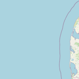
Map view of Husby Sø og Nørresø

Use this park location map to pinpoint Husby Sø og Nørresø in Denmark, understand its exact geographic position, and read its mapped placement within the surrounding landscape more clearly.

Pigeon | © OpenStreetMap contributors

Location context for Husby Sø og Nørresø

Region Midtjylland
Recorded earthquake history

Explore Recorded Seismic History and Earthquake Data for Husby Sø og Nørresø

View a comprehensive catalogue of historical seismic events associated with the area around Husby Sø og Nørresø. MoriAtlas provides detailed event logs including magnitude, depth, and epicentre proximity for those examining the regional seismic history of this Danish wetland landscape.

Husby Sø og Nørresø Earthquake History

Catalogued events

1 event

Strongest magnitude

Magnitude 3.8

Most recent event

Sep 16, 2018

This history includes earthquakes recorded inside the park or within 50 km of its borders

Park atlas

Compare adjacent wetland habitats, shallow lakes, and regional conservation areas

Other Parks Near Husby Sø og Nørresø and Surrounding Protected Landscapes

Browsing other parks near Husby Sø og Nørresø reveals connected wetland habitats and coastal plain terrain across western Jutland. Comparing adjacent protected areas provides a broader regional context for shallow lake ecosystems and lowland plant diversity.
A pale, minimalist watercolor painting showing a green grassy island in the middle of a calm, reflective lagoon under a soft pink and white sky.
Protected areaRegion Midtjylland
1.1 km away#1 closest

North

Nissum Fjord Protected Area: Geography and Coastal Wetland Map of Region Midtjylland

A diverse mosaic of dune systems, lagoon basins, and freshwater habitats

Nissum Fjord stands as a central protected wetland complex on the western Jutland coast. This area provides a comprehensive view of coastal geography, ranging from fixed dune heaths and sea-buckthorn scrub to the quiet, shallow waters of its three interconnected basins. Its protected boundaries include the island of Fjandø and significant inland lake systems, offering a distinct study in Denmark's coastal transitions and avian staging environments.

Area
109.67 km²
Established
2011
Relief
Lowland
Climate
Temperate
Protected areaRegion Midtjylland
6.1 km away#2 closest

South

Kimmelkær Landkanal: Mapped Protected Area and Regional Geography in Midtjylland

A rare aquatic habitat within the Ringkøbing Fjord water system.

Focusing on a narrow canal corridor, Kimmelkær Landkanal serves as a vital protected area for threatened aquatic species. Its geography is characterized by soft sandy sediments and a distinct parallel channel structure, connecting small watercourses to the larger wetland ecosystems of the Stadil Fjord catchment area.

Area
0.03 km²
Established
2011
Relief
Lowland
Scope
Terrestrial
Protected areaDenmark
About 7.5 km away#3 closest

South

Natura 2000 area no. 66 Stadil Fjord og Vest Stadil Fjord Coastal Wetland Complex

Protected lagoon and dune landscape in western Jutland, Denmark.

Natura 2000 area no. 66 Stadil Fjord og Vest Stadil Fjord comprises a significant coastal lagoon system, encompassing shallow brackish waters, reed beds, and surrounding dune heaths. This protected area supports a high degree of botanical diversity and provides essential habitat for various bird species, serving as a primary example of Denmark's complex hydrological and coastal geography.

Area
69.03 km²
Relief
Lowland
Climate
Temperate
Access
Easy access
Nature reserveCentral Denmark Region
About 18 km away#4 closest

East

Heder og klitter på Skovbjerg Bakkeø, Idom Å og Ormstrup Hede Nature Reserve Atlas and Map

Mapping glacial moraine and inland dune landscapes in the Central Denmark Region

The protected area surrounding Heder og klitter på Skovbjerg Bakkeø, Idom Å og Ormstrup Hede comprises extensive inland dunes and heathlands anchored by a Saalian moraine hill island. This site serves as a crucial ecological link, featuring restored riparian stream habitats and rare forest remnants that provide deep insight into Denmark’s post-glacial geological development.

Area
22.14 km²
Established
1985
Relief
Lowland
Scope
Terrestrial
A pale watercolor landscape painting of a quiet fjord with soft green and pink marshy vegetation in the foreground and rolling hills in the background.
Protected areaRegion Midtjylland
19 km away#5 closest

South

Ringkøbing Fjord og Nymindestrømmen: Coastal Lagoon and Protected Wetland Geography

A vast Danish wetland complex in Region Midtjylland.

Ringkøbing Fjord og Nymindestrømmen defines the Danish west coast through its unique combination of brackish lagoons, salt meadows, and dune belts. This protected area integrates the Skjern Å river delta and the freshwater-lagoon chain of Nymindestrømmen, creating an internationally significant habitat for diverse waterbirds and migratory species across its multi-layered terrain.

Area
276.84 km²
Relief
Lowland
Climate
Temperate
Scope
Mixed
Protected areaDenmark
32 km away#6 closest

North

Nissum Bredning Protected Area: Geography and Coastal Mapping in Denmark

Shallow bay ecosystems, glacial cliffs, and Limfjorden sand flats.

Nissum Bredning is a broad, low-lying basin in western Denmark known for its extensive shallow sand flats, including Fjordgrund and Gåseholm. The protected area encompasses a diverse coastal mosaic of brackish lagoons, salt meadows, and the distinctive Toftum Bjerge glacial cliff. This geography offers a clear view into the intersection of active North Sea currents and sheltered inland fjord environments.

Area
200 km²
Relief
Lowland
Climate
Temperate
Access
Easy access
Protected areaRegion Midtjylland
About 38 km away#7 closest

Northeast

Natura 2000-område nr. 62 Veno, Veno Sund: Protected Coastal and Marine Landscape Map

Regional geography and protected coastal habitat overview

Analyze the protected area characteristics of Natura 2000-område nr. 62 Veno, Veno Sund, where shallow brackish sound meets dune heaths and calcareous grasslands. This site provides essential habitat for waders and marine mammals within the broader Limfjorden ecosystem in Region Midtjylland.

Area
29.26 km²
Established
2011
Relief
Lowland
Climate
Temperate
Nature reserveRegion Midtjylland
About 41 km away#8 closest

Southeast

Natura 2000-område nr. 68 Skjern Å: Protected Riverine Geography and Valley Landscapes

A central Jutland nature reserve featuring glacial valley systems

Explore the geographic boundary and habitat diversity of Natura 2000-område nr. 68 Skjern Å. This protected landscape preserves the vital connection between freshwater river channels, raised bogs, and open heathland, serving as a landmark for regional river management and biodiversity conservation in western Denmark.

Area
25.8 km²
Established
2011

Common questions about visiting, size, designation, and location context for Husby Sø og Nørresø

Husby Sø og Nørresø FAQs for park facts, access, geography, and protected area context

Find quick answers about Husby Sø og Nørresø, including protected-area facts, park geography, trail and visitor context, and how the park fits into its surrounding country and regional landscape.
MoriAtlas Explorer

Continue Your Protected Areas Search Across the Global Atlas

Deepen your exploration by continuing the structured search for national parks and protected areas worldwide. Utilize the comprehensive filtering capabilities to compare different conservation landscapes and refine your understanding of global park geography. Discover more about the distribution and characteristics of protected natural areas.

Global natural geography
