Mori Atlas logo
Wildlife reserveIlog-Hilabangan Watershed Forest Reserve

Mapping the watershed boundaries and rugged mountain terrain of this Western Visayas forest reserve

Ilog-Hilabangan Watershed Forest Reserve: A Protected Wildlife Landscape on Negros Island

The Ilog-Hilabangan Watershed Forest Reserve spans over 10,000 hectares of rugged, high-elevation tropical rainforest within the province of Negros Occidental. This protected wildlife reserve functions as a critical catchment for the Ilog and Hilabangan river systems, safeguarding essential watershed hydrology while harboring diverse endemic Philippine forest species. Its dissected mountain terrain serves as an ecological anchor for the interior landscapes of western Negros.

tropical rainforestwatershed reservedipterocarp forestmountain forestendemic wildlifeisland biodiversity

Ilog-Hilabangan Watershed Forest Reserve

Wildlife reserve

Park overview

Structured park overview, official facts, and landscape profile for Ilog-Hilabangan Watershed Forest Reserve

Ilog-Hilabangan Watershed Forest Reserve park facts, protected area profile, and essential visitor context

Review the core facts for Ilog-Hilabangan Watershed Forest Reserve, including designation, size, terrain, visitor scale, habitats, and operating context in one park-focused overview.

About Ilog-Hilabangan Watershed Forest Reserve

The Ilog-Hilabangan Watershed Forest Reserve occupies a significant inland block of the Negros Island mountainous interior. Although Negros is one of the largest islands in the Visayan group of the Philippines, much of its once-extensive lowland forest has been cleared for sugar cultivation and settlement, leaving steep upland forests such as this reserve as critical refuges for native wildlife.

Within the reserve, the terrain is strongly dissected, with ridges and valleys that channel rainfall into the Ilog River system and the headwaters of the Hilabangan River. This watershed function is central to the area's protected status, since downstream communities and farmland depend on stable, clean runoff from these forests. At the same time, the elevation gradient and varied topography create a mosaic of microhabitats that supports a rich tropical forest community.

Forest composition reflects classic Philippine lowland tropical rainforest, with dipterocarps prominent in the canopy. Botanists working in the reserve have catalogued roughly 108 tree species and about 190 additional plant species, including understory shrubs and herbaceous plants. The forest provides habitat for a wide range of Philippine avifauna, mammals, reptiles, and amphibians, several of which are endemic to the country or otherwise of conservation concern.

Because the reserve sits within a network of protected natural areas in Western Visayas that includes Mount Kanlaon Natural Park, Northern Negros Natural Park, and various marine reserves along the coast, it contributes to broader efforts to maintain ecological connectivity in one of the most biologically rich but heavily altered regions of the Philippines.

Quick facts and research context for Ilog-Hilabangan Watershed Forest Reserve

The Ilog-Hilabangan Watershed Forest Reserve is located on the island of Negros in the Western Visayas region of the Philippines, specifically in Negros Occidental province. It was formally established as a combined watershed and forest reserve on June 28, 1990, and covers approximately 102 square kilometers of interior mountain terrain. The reserve lies in the catchment basins of the Ilog River and the upper Hilabangan River, and is bordered by the city municipalities of Himamaylan and Kabankalan.

Its elevations exceed 1,000 meters at the highest peaks, and its forests are known to support around 108 tree species, a diverse understory of herbs and shrubs, 65 recorded bird species, and about 10 mammal species, several of them endemic or threatened.

Protection and recognition

Documented terrestrial boundary management, designation history, and recognition records

Ilog-Hilabangan Watershed Forest Reserve Protection Status and Governance Data

Comprehensive protected area records outline the terrestrial conservation status and management scope established for Ilog-Hilabangan Watershed Forest Reserve. Official protection metrics and verified registry designations provide structured context for exploring this designated natural landscape.

Protection details

Protection scope
Terrestrial
Transboundary protection
No
WDPA ID
306458
Park context

Deeper park guide and search-rich context for Ilog-Hilabangan Watershed Forest Reserve

Ilog-Hilabangan Watershed Forest Reserve history, landscape, wildlife, and travel context

Explore Ilog-Hilabangan Watershed Forest Reserve through its history, landscape character, ecosystems, wildlife, conservation priorities, cultural context, and seasonal travel timing in a structured park guide built for atlas discovery and search intent.

Why Ilog-Hilabangan Watershed Forest Reserve stands out

The Ilog-Hilabangan Watershed Forest Reserve is best known for combining watershed protection with conservation of tropical lowland and montane rainforest on western Negros. Its rugged mountain landscape reaches above 1,000 meters and feeds both the Ilog River and the Hilabangan River, making the reserve ecologically important for downstream water supply as well as for native biodiversity. The forest is also notable for supporting an unusually concentrated assemblage of Philippine forest wildlife, including threatened hornbills, parrots, the Visayan warty pig, the endangered Prince Alfred's deer, and several endemic fruit bats. This combination of hydrological function and biodiversity value defines the reserve's identity within the Western Visayas protected-area network.

Ilog-Hilabangan Watershed Forest Reserve history and protected-area timeline

The Ilog-Hilabangan Watershed Forest Reserve was formally established on June 28, 1990, by the Philippine government as a combined watershed and forest reserve within the province of Negros Occidental. The designation recognized both the hydrological importance of the Ilog River catchment and the upper Hilabangan River headwaters, and the value of the remaining tropical forest cover in the mountainous interior of western Negros.

The reserve was created against a backdrop of widespread lowland forest loss on Negros Island, where large areas had been converted to agriculture and other land uses over the preceding decades. By setting aside the rugged upper watersheds as a protected area, the government sought to secure long-term water supply for downstream communities and to preserve remnant forest habitat for native species.

Much of the reserve's biological knowledge has been built through dedicated flora and fauna assessments. A floral and faunal assessment of the Ilog-Hilabangan Watershed Forest Reserve in Negros Occidental, referenced through the Philippine Council for Agriculture, Aquatic and Natural Resources Research and Development (PCARRD), has provided key baseline data on tree, plant, bird, and mammal composition, and the reserve is recognized in international databases such as the World Database on Protected Areas.

Ilog-Hilabangan Watershed Forest Reserve landscape and geographic character

The reserve occupies a rugged, deeply dissected section of Negros Island. Its interior reaches summits above 1,000 meters in elevation, with steep slopes, narrow valleys, and forested ridges that shape both the local climate and the hydrology of the area. This broken terrain lies inland of the more populated lowlands and coastal cities of Himamaylan and Kabankalan.

The watershed character of the landscape is fundamental. Ridges and basins channel rainfall into the headwaters of the Hilabangan River and into the broader catchment of the Ilog River, two of the significant drainage systems flowing down the western side of Negros Island. Elevation, slope, and forest cover together regulate runoff, sediment flow, and water quality downstream.

The reserve is essentially a continuous forested upland block, with limited roads or settlements within its boundaries. Its physical character, dense ridges interspersed with river valleys, makes the area difficult to access, which has helped to keep much of the forest cover intact relative to surrounding lowlands.

Ilog-Hilabangan Watershed Forest Reserve ecosystems, habitats, and plant life

The reserve protects Philippine lowland tropical rainforest, including dipterocarps and other characteristic canopy species of the Visayan forests. Forest composition is relatively diverse for an area of this size, with roughly 108 documented tree species and a further 190 plant species in the understory, including numerous herbs and shrubs.

The combination of elevation gradient, intact canopy, and isolation from heavily populated lowlands creates conditions for a layered tropical forest ecosystem: tall overstory trees, a dense middle story of smaller trees and palms, and a shaded understory of ferns, herbs, and woody seedlings. Such structural complexity supports a broad range of forest-dependent animals.

Because lowland forest is scarce elsewhere in the region, the reserve's habitat mosaic is particularly important for species that have lost much of their former range on Negros. The ecosystem functions as both a watershed buffer and a biodiversity reservoir.

Ilog-Hilabangan Watershed Forest Reserve wildlife and species highlights

The Ilog-Hilabangan Watershed Forest Reserve supports a rich vertebrate fauna typical of Philippine rainforest. Surveys have recorded about 65 bird species, including roughly 63 that breed within the reserve. Among the resident and migrant birds, the Barn Swallow and Brown Shrike use the area during migration, while threatened species include the Blue-naped Parrot, the Visayan Tariktik Hornbill, and the Walden's Hornbill, all of which are recognized as endangered by the IUCN.

Mammal diversity is more modest but ecologically significant: about 10 mammal species have been recorded in the area. The reserve hosts the Visayan warty pig, a species endemic to the central Philippine islands, and the Prince Alfred's deer, another Visayan endemic of considerable conservation importance. Fruit bats are especially well represented, with five species recorded in the reserve, including the large Golden-crowned Flying Fox. Three of these mammal species are endemic to the Philippines.

The reserve also supports various reptiles and amphibians. Notable species include the Reticulated Python, emerald tree skinks, the Tokay Gecko, the Common Flying Dragon, and forest frogs. The presence of such a wide range of forest wildlife, including several island endemics, underlines the importance of the protected area as a refuge within a largely deforested regional landscape.

Ilog-Hilabangan Watershed Forest Reserve conservation status and protection priorities

The Ilog-Hilabangan Watershed Forest Reserve is a designated protected area under Philippine law, recognized both nationally through the Protected Areas and Wildlife Bureau (PAWB) and internationally in the World Database on Protected Areas. Its dual designation as a watershed and forest reserve reflects its core conservation purpose: protecting upland forest cover that regulates water supply and biodiversity on a heavily developed island.

From a watershed perspective, the reserve is critically important. Forest cover in the Ilog River catchment and the Hilabangan River headwaters directly influences the quality and reliability of water available to downstream communities and agricultural areas in Negros Occidental, including the cities of Himamaylan and Kabankalan. Forest loss or degradation within the reserve could therefore have outsized effects on regional water security and on flood and sediment behavior.

From a biodiversity perspective, the reserve provides habitat for several endemic and threatened species, including the Visayan warty pig, Prince Alfred's deer, the Golden-crowned Flying Fox, and multiple threatened hornbills and parrots. Because lowland forest on Negros has been extensively cleared, the reserve acts as a critical refugium where these species can persist. Its conservation significance is heightened by its position within the broader Western Visayas protected-area system, which links upland forest reserves on Negros and Panay with coastal and marine protected areas such as Sagay Marine Reserve and Taklong Island National Marine Reserve.

Top sights and standout views in Ilog-Hilabangan Watershed Forest Reserve

The Ilog-Hilabangan Watershed Forest Reserve stands out as a large upland forest reserve on western Negros that protects both a vital watershed and a rich community of Philippine wildlife. Its rugged terrain, reaching above 1,000 meters, channels water into the Ilog and Hilabangan river systems while supporting dipterocarp-dominated tropical rainforest with hundreds of recorded plant species.

The reserve is particularly significant for conserving Visayan endemics such as the Visayan warty pig and the Prince Alfred's deer, as well as threatened hornbills and parrots, and a community of fruit bats including the Golden-crowned Flying Fox. Within the Western Visayas network of protected areas, the reserve plays a complementary role alongside Mount Kanlaon, Northern Negros Natural Park, and the region's marine reserves.

Best time to visit Ilog-Hilabangan Watershed Forest Reserve

The reserve lies in a tropical climate zone on Negros Island, where conditions are warm year-round and rainfall is influenced by the annual monsoon patterns. As a forested mountain watershed with river systems, the area tends to be more accessible and pleasant during the drier months when trails and forest paths are easier to traverse, while the wetter season brings heavier rains, swollen rivers, and thicker vegetation growth that can make movement more challenging.

For those interested in birdwatching or general forest wildlife observation, drier months typically offer more manageable conditions for moving through dipterocarp forest and listening for forest birds, hornbills, and fruit bats. Wet season visits, while more difficult, can be dramatic in terms of forest greenery, river flow, and amphibian activity. Visitors should plan around the realities of upland tropical weather rather than around temperature, which remains relatively stable throughout the year.
Monthly climate preview

Long-term annual temperature and precipitation patterns from representative coordinates

Ilog-Hilabangan Watershed Forest Reserve Climate Normals and Weather by Month

Historical climatology records for Ilog-Hilabangan Watershed Forest Reserve outline a measured annual rhythm of monthly average temperatures and daily precipitation rates. Examining the full twelve-month profile provides deeper insight into long-term climate variations across the protected watershed.
Annual mean26 °C
25 °C28 °C
Jan25°
Feb25°
Mar26°
Apr27°
May28°
Jun26°
Jul26°
Aug25°
Sep25°
Oct26°
Nov25°
Dec25°
Warmest month
May

27.5 °C

Coolest month
January

24.5 °C

Wettest month
July

8.6 mm/day

Driest month
March

2.1 mm/day

Park location guide

Geography guide, regional context, and park location map for Ilog-Hilabangan Watershed Forest Reserve

Ilog-Hilabangan Watershed Forest Reserve park geography, regions, and map view in Philippines

Understand where Ilog-Hilabangan Watershed Forest Reserve sits in Philippines through a broader geographic reading of the surrounding landscape, nearby location context, and its mapped position within the national park landscape.

How Ilog-Hilabangan Watershed Forest Reserve fits into Philippines

The Philippines, officially the Republic of the Philippines, is an archipelagic nation in Southeast Asia comprising approximately 7,641 islands categorized into three main geographical divisions: Luzon, Visayas, and Mindanao. Located in the western Pacific Ocean, it shares maritime borders with Taiwan, Japan, Palau, Indonesia, Malaysia, Vietnam, and China. Manila serves as the capital city, while Quezon City is the most populated city, both within Metro Manila.

Wider geography shaping Ilog-Hilabangan Watershed Forest Reserve in Philippines

The Philippines is an archipelagic nation in Southeast Asia, positioned in the western Pacific Ocean. Its islands are bounded by the South China Sea to the west, Philippine Sea to the east, and Celebes Sea to the south. The country shares maritime borders with Taiwan to the north, Japan to the northeast, Palau to the east and southeast, Indonesia to the south, Malaysia to the southwest, Vietnam to the west, and China to the northwest.

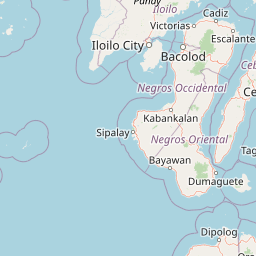
Map view of Ilog-Hilabangan Watershed Forest Reserve

Use this park location map to pinpoint Ilog-Hilabangan Watershed Forest Reserve in Philippines, understand its exact geographic position, and read its mapped placement within the surrounding landscape more clearly.

Pigeon | © OpenStreetMap contributors

Location context for Ilog-Hilabangan Watershed Forest Reserve

Negros Occidental
Park atlas

Compare regional mountain terrain, river headwaters, and connected lowland rainforest habitats

Explore Parks Near Ilog-Hilabangan Watershed Forest Reserve and Surrounding Protected Areas

Browse nearby national parks and protected areas sharing similar tropical forest ecosystems across the Western Visayas region. Comparing adjacent mountain reserves provides broader geographic context for island biodiversity and watershed conservation.
A watercolor painting featuring soft green hills in the midground and faint, pale purple mountain silhouettes in the background against a white backdrop.
National parkNegros Occidental
About 55 km away#1 closest

North

Mount Kanlaon Natural Park: Mapping the Volcanic Heart of Negros Island Protected Lands

A comprehensive geographic overview of volcanic terrain and rainforest habitats.

Mount Kanlaon Natural Park protects a defining massif in the Western Visayas, blending active volcanic features with some of the most intact tropical rainforests remaining on Negros Island. This geographic record maps the transition from steep, high-elevation ridges to lower-altitude forest boundaries, providing context on its importance as a refuge for threatened endemic wildlife and a significant center for regional biodiversity conservation.

Area
248.54 km²
Established
1934
Relief
Mountain
Scope
Terrestrial
National parkCebu
About 74 km away#2 closest

East

Guadalupe Mabugnao Mainit Hot Spring National Park: Protected Landscape and Watershed Geography

Explore hot springs, caves, and mapped terrain in Cebu.

Guadalupe Mabugnao Mainit Hot Spring National Park is a protected national park in Cebu, Philippines, recognized for its significant watershed function and unique natural features. Spanning forested highland terrain within the Mantalongon mountain range, the park protects natural hot springs, explored cave systems such as Cave Lorett, and river networks vital to local water supply. Its identity as a protected landscape offers rich opportunities for geographic exploration, mapping its boundaries, and understanding its role within the regional natural terrain and conservation efforts.

Area
0.575 km²
Established
1972
IUCN
V
Relief
Mountain
Marine protected areaVisayas
About 81 km away#3 closest

Northeast

Tañon Strait Protected Seascape: Marine Geography and Protected Landscape Analysis

An expansive marine passage located within the central Visayas island group.

As the largest marine protected area in the Philippines, the Tañon Strait Protected Seascape represents a complex aquatic geography spanning 160 kilometres. Its protected waters serve as a vital corridor for marine biodiversity, linking the northern Visayan Sea to the southern Bohol Sea. This resource provides a detailed look at the strait's maritime boundaries, coastal ecosystems, and the distinct underwater terrain that defines this critical conservation zone.

Area
5,000 km²
Established
1998
IUCN
V
Scope
Marine
A horizontal watercolor painting showing a soft, hazy landscape with a body of water in the foreground, grassy banks, and rolling hills in the distance.
National parkCentral Visayas
About 102 km away#4 closest

East

Panglao Island Protected Seascape: Geographic Atlas and Marine Park Boundaries

A vital protected marine zone in Central Visayas

The Panglao Island Protected Seascape acts as a key site for studying tropical marine biodiversity and karst-driven coastal geography in the Philippines. Spanning the waters around Panglao Island, this protected area features a mosaic of coral reefs, white sand beaches, and offshore limestone islets that provide essential habitats for thousands of mollusk and crustacean species.

Area
91.12 km²
Established
2018
Relief
Mixed relief
Scope
Mixed
National parkPhilippines
About 122 km away#5 closest

North

Bulabog Putian National Park: Philippines National Park Geographic Context and Mapped Boundaries

Discover the protected landscape identity and regional atlas significance.

Bulabog Putian National Park stands as a designated national park in the Philippines, offering valuable insights for geographic and protected-area exploration. Users can understand its specific location and mapped presence within the country's natural landscape, contributing to a structured atlas of conservation areas. This entry focuses on the park's identity and geographic setting for informed discovery.

Area
8.543 km²
Established
1961
IUCN
V
Relief
Mountain
A watercolor painting showing a panoramic view of a lush wetland landscape with gentle green hills in the distance, a winding stream, and tall grasses and pink wildflowers in the foreground.
Wildlife reserveCentral Visayas
About 124 km away#6 closest

East

Olango Island Wildlife Sanctuary: Coastal Protected Area and Migratory Bird Habitat in Central Visayas

Explore the interconnected mudflats, reefs, and mangrove forest ecosystems

Olango Island Wildlife Sanctuary stands as a key protected landscape in the Central Visayas, defined by its vast tidal flats and critical role in international bird migration patterns. This site features a unique mosaic of salt marshes, seagrass beds, and coral reef systems that support diverse coastal life within the low-lying terrain of the Olango Island Group.

Area
10.3 km²
Established
1992
Relief
Lowland
Climate
Tropical
Protected landscapeBohol
About 131 km away#7 closest

East

Rajah Sikatuna Protected Landscape: Mapping the Limestone Forest of Bohol, Philippines

A vital protected area of karst ridges and endemic forest habitats

Rajah Sikatuna Protected Landscape sits as a premier natural landmark in southern Bohol. This area is defined by its extensive karst topography, significant cave systems, and expansive limestone forests. It serves as an essential ecological anchor for the province, offering a unique perspective on the island's diverse upland geography and natural mountain systems.

Area
104.526 km²
Established
1987
IUCN
V
Relief
Mountain
A soft watercolor painting of a coastal landscape with green rolling hills, distant faint mountains, and light water reflections.
Protected landscapeLeyte
About 196 km away#8 closest

East

Cuatro Islas Protected Landscape/Seascape: Leyte Marine and Island Geography Exploration

Detailed protected area atlas for the Camotes Sea island group

The Cuatro Islas Protected Landscape/Seascape is a notable Philippine conservation zone consisting of four distinct islands including Apid, Mahaba, Digyo, and Himokilan. This geographic profile details the diverse terrain, ranging from uplifted former coral reefs to coral sand islets, while providing a clear understanding of the surrounding marine ecosystem and its role in regional conservation.

Area
125 km²
Established
2000
Scope
Mixed

Common questions about visiting, size, designation, and location context for Ilog-Hilabangan Watershed Forest Reserve

Ilog-Hilabangan Watershed Forest Reserve FAQs for park facts, access, geography, and protected area context

Find quick answers about Ilog-Hilabangan Watershed Forest Reserve, including protected-area facts, park geography, trail and visitor context, and how the park fits into its surrounding country and regional landscape.
MoriAtlas Explorer

Continue Your Protected Areas Search Across the Global Atlas

Deepen your exploration by continuing the structured search for national parks and protected areas worldwide. Utilize the comprehensive filtering capabilities to compare different conservation landscapes and refine your understanding of global park geography. Discover more about the distribution and characteristics of protected natural areas.

Global natural geography