Mori Atlas logo
Nature reserveIn der Striet bei Vöckelsbach

Understanding the mapped boundaries and wetland forest landscape of this critical Odenwald refuge

In der Striet bei Vöckelsbach: A Detailed Geographic Atlas of the Nature Reserve in Hesse, Germany

(Naturschutzgebiet In der Striet bei Vöckelsbach)

In der Striet bei Vöckelsbach represents a vital nature reserve located within the low mountain range of the Odenwald in southern Hesse. This atlas entry examines the compact ecological mosaic of spring fed streams, alder swamps, and mixed deciduous woodlands found at the foot of the Götzenstein hill. The site offers a unique perspective on protected valley geography, showcasing how small scale refuges support sensitive fauna like the stone crayfish and brook lamprey within a wider regional network.

nature reserveOdenwaldspring-fed streamwetland forestalder swampmixed deciduous forest

In der Striet bei Vöckelsbach

Nature reserve

Park overview

Structured park overview, official facts, and landscape profile for In der Striet bei Vöckelsbach

In der Striet bei Vöckelsbach park facts, protected area profile, and essential visitor context

Review the core facts for In der Striet bei Vöckelsbach, including designation, size, terrain, visitor scale, habitats, and operating context in one park-focused overview.

About In der Striet bei Vöckelsbach

In der Striet bei Vöckelsbach is a compact but ecologically rich nature reserve in the Odenwald of southern Hesse. Located south of the village of Vöckelsbach within the municipality of Mörlenbach, the reserve protects the spring head of the Vöckelsbach stream and two small unnamed tributaries that flow into it. The broader setting lies within the Eichelberg-Odenwald natural region at the foot of the Götzenstein, a wooded hill that frames the southern edge of the protected area.

The landscape of the reserve is defined by water rather than elevation. The springs rise within the wooded valley, and the brooks converge at the northern exit of the reserve into the Försterteich, a small forest pond. From this pond the Vöckelsbach leaves both the woodland and the protected area, meandering along the forest edge toward the north. This configuration means that the entire upper catchment of the stream falls within the protected zone, providing a continuous corridor from the springs through the wetland and into the downstream valley.

Ecologically, the area preserves a rare and biologically valuable mosaic in a region that has otherwise been heavily shaped by agriculture and settlement. What began as a traditional forest meadow has reverted into dense scrub and shrubland through natural succession, and today the reserve contains reed and sedge beds, wet alder woodland, brook floodplain forest, and surrounding mixed deciduous forest with old trees. This gradient from open wetland to closed forest supports numerous threatened species of mosses, vascular plants, amphibians, and stream invertebrates.

Administratively, In der Striet bei Vöckelsbach has been a formal nature reserve since 30 November 1988. It is part of the Geo-Naturpark Bergstraße-Odenwald, a UNESCO Global Geopark spanning the Bergstraße region and the Odenwald, and the Vöckelsbach stream within the reserve is fully included in the Natura 2000 FFH area covering the upper Weschnitz and its tributaries. These layered designations reflect the area's significance at regional, national, and European conservation levels.

Quick facts and research context for In der Striet bei Vöckelsbach

In der Striet bei Vöckelsbach is a designated nature reserve, or Naturschutzgebiet, in the southern Odenwald of Hesse, Germany. It lies within the municipality of Mörlenbach in the Bergstraße district and belongs to the natural region known as Eichelberg-Odenwald. The reserve occupies only about 4.79 hectares, but protects a concentrated mosaic of spring-fed streams, sedge and reed beds, alder swamp forest, brookside woodland, and mixed deciduous forest.

The area was placed under formal nature protection on 30 November 1988 under the identifier 1431014, and is part of the Geo-Naturpark Bergstraße-Odenwald. The stream course of the Vöckelsbach within the reserve also belongs to the Natura 2000 FFH site covering the upper Weschnitz and its tributary waterways.

Protection and recognition

Examine documented protection parameters, management scope, and verified registry entries.

In der Striet bei Vöckelsbach Protection Status and Official Designation Record

In der Striet bei Vöckelsbach maintains formal protected area records cataloged under standardized international databases. Structured registry tracking provides transparent access to documented conservation status and associated administrative details.

Protection details

WDPA ID
163913
Park context

Deeper park guide and search-rich context for In der Striet bei Vöckelsbach

In der Striet bei Vöckelsbach history, landscape, wildlife, and travel context

Explore In der Striet bei Vöckelsbach through its history, landscape character, ecosystems, wildlife, conservation priorities, cultural context, and seasonal travel timing in a structured park guide built for atlas discovery and search intent.

Why In der Striet bei Vöckelsbach stands out

The reserve is best known for its spring-fed stream system and its remarkably varied wetland-forest mosaic despite its very small size. The protected habitats include reeded and sedge wetland, alder swamp forest, and brookside mixed forest along the upper course of the Vöckelsbach. It is also recognized for hosting threatened animal and plant species typical of moist Odenwald valleys, including amphibians near the Försterteich pond and sensitive stream fauna such as the brook lamprey and stone crayfish in the headwater reaches.
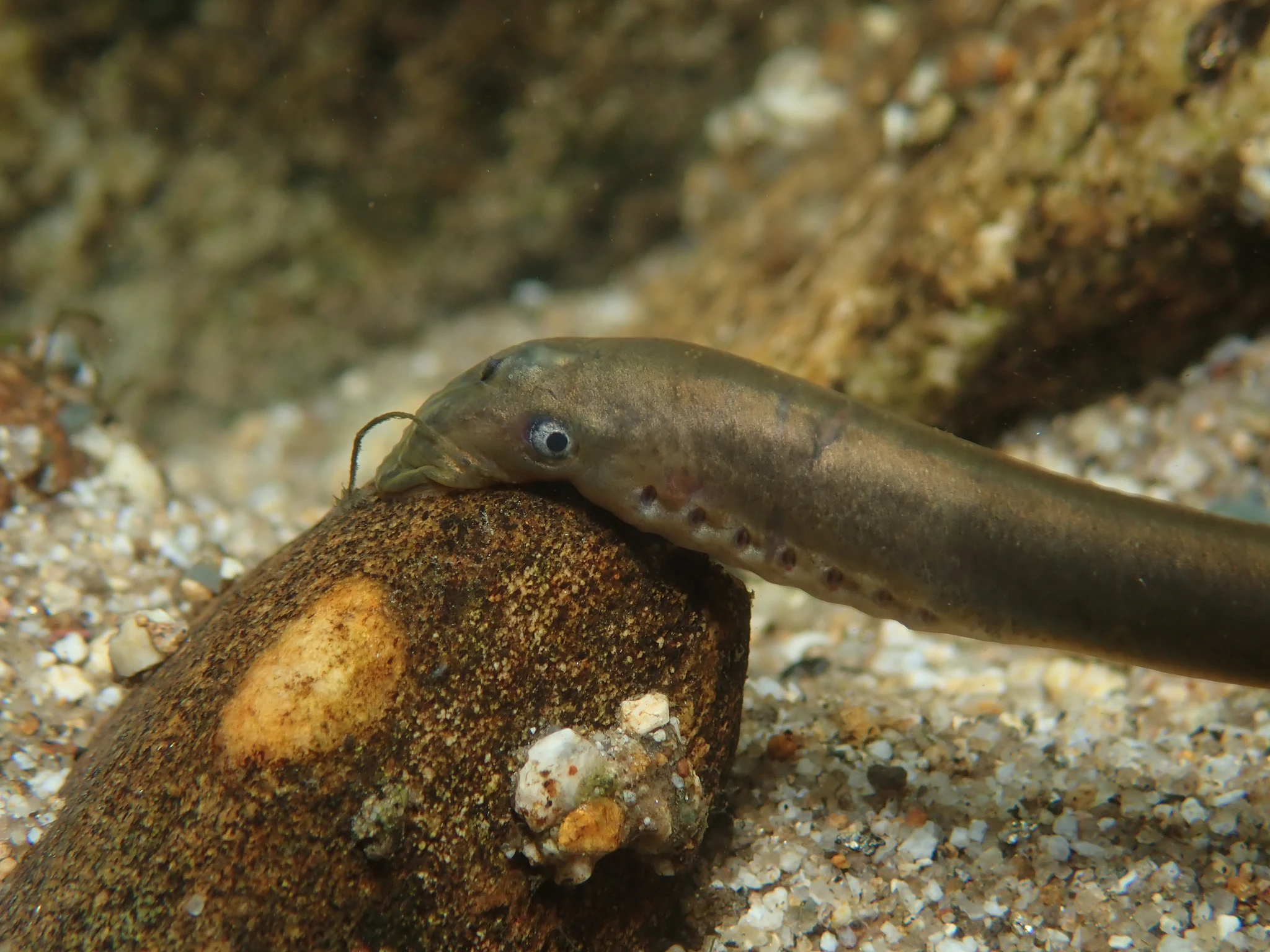
Close-up of a brown, eel-like European Brook Lamprey resting its head on a submerged rock in a sandy stream bed.
A European brook lamprey (Lampetra planeri) resting on a stone in a stream bed.

In der Striet bei Vöckelsbach history and protected-area timeline

The protected area has a relatively recent formal history, although the landscape itself reflects older patterns of land use. The reserve was officially designated as a Naturschutzgebiet, or nature reserve, on 30 November 1988 under the identifier 1431014. Its protection was prompted by the ecological value of the spring-fed brook system and the surrounding woodland in an otherwise heavily used part of the Odenwald.

Before designation, the core of the present reserve consisted of a former forest meadow that had been gradually abandoned. Without continued mowing or grazing, the open meadow slowly converted through natural ecological succession into dense scrub and shrub-dominated vegetation, and eventually into wet woodland dominated by alder and other moisture-loving species. Rather than being seen as degradation, this succession was recognized as creating a richly varied habitat mosaic worthy of formal protection.

In later years, the area was integrated into broader regional and European conservation frameworks. It became part of the Geo-Naturpark Bergstraße-Odenwald, and the stream course of the Vöckelsbach within the reserve was included in the Natura 2000 FFH site designated for the upper Weschnitz and its tributary waterways, reinforcing its recognition beyond the borders of the Bergstraße district.

In der Striet bei Vöckelsbach landscape and geographic character

The landscape of In der Striet bei Vöckelsbach is shaped by its position within a deeper, spring-fed valley rather than by dramatic topography. The reserve lies in the Odenwald, a low mountain range where broad forested ridges and valleys dominate the scenery, and it occupies a small side valley south of the village of Vöckelsbach. At the southern edge of the protected area rises the Götzenstein, a wooded hill that influences drainage patterns and provides a forested backdrop.

Within the reserve, the terrain is gentle and water-influenced. The springs of the Vöckelsbach emerge from the valley floor, and the small brooks run through a network of shallow channels before reaching the Försterteich, a small pond at the lower end of the protected area. Beyond this point, the Vöckelsbach exits the woodland and meanders north along the forest edge, marking a clear transition between the closed-canopy valley reserve and the more open countryside downstream.

The vegetation transitions visible across this small area reflect the hydrology: from open reed and sedge patches around the springs and pond, through wet alder woodland along the brooks, to mixed deciduous forest on slightly higher, drier ground. This layered pattern of habitats within a compact footprint is one of the defining features of the landscape here.
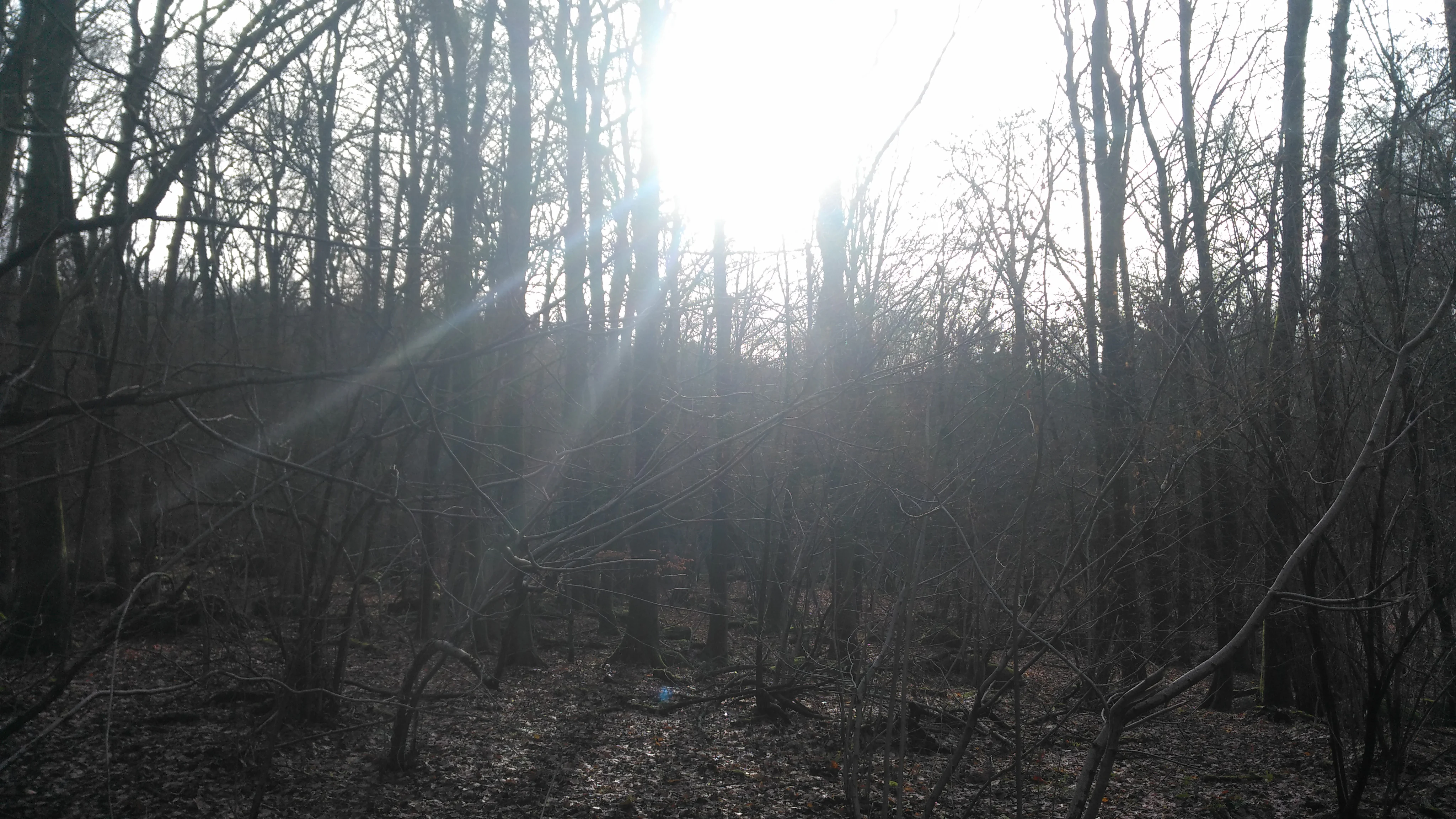
A backlit view of a dense, leafless forest in early spring or winter, with bright sunlight filtering through the thin tree trunks.
Sunlight filtering through the deciduous forest canopy in the In der Striet nature reserve.

In der Striet bei Vöckelsbach ecosystems, habitats, and plant life

The nature reserve protects one of the most habitat-diverse small areas in the southern Odenwald. The hydrology of the site creates a dense ecological mosaic that includes reeded and sedge wetland, low shrubby vegetation, alder-dominated swamp forest, brook floodplain forest, and mixed deciduous forest on slightly elevated ground. This combination is the result of natural succession acting on a former forest meadow, leading to a gradual transformation from open habitat to closed wet woodland over decades.

The presence of standing and flowing water is central to the area's ecological character. The springs feed small brooks that traverse the reserve before joining the Försterteich pond, creating zones of continually saturated soil that support moisture-loving plant communities. In the surrounding forest, older mixed deciduous trees contribute dead wood and structural diversity that benefit woodland species, including fungi, lichens, mosses, and invertebrates associated with decaying timber.

Because the area lies within a Natura 2000 FFH site, its habitat types are not only of regional but also of European conservation interest. The combination of small-scale wetland habitats with surrounding deciduous woodland makes the site disproportionately important for biodiversity given its small size.

In der Striet bei Vöckelsbach wildlife and species highlights

The reserve hosts a notably rich community of animal species typical of moist Odenwald valleys. Amphibians are particularly prominent around the Försterteich pond at the northern edge of the protected area, where breeding and foraging habitat coincide. Stream-dependent fauna is similarly significant, with the upper reaches of the Vöckelsbach providing habitat for sensitive species such as the brook lamprey, a small jawless fish that requires clean, well-oxygenated gravel beds, and the stone crayfish, a threatened freshwater crustacean that depends on cool, structured stream environments.

Beyond these headline species, the mosaic of reed beds, scrub, wet woodland, and mixed deciduous forest supports diverse invertebrates, moss-dwelling fauna, and forest birds associated with older trees and structurally varied woodland. Numerous species recorded in the area are regarded as threatened at regional or national level, reflecting the value of unbroken habitat gradients from open wetland to mature forest within a single protected site.

In der Striet bei Vöckelsbach conservation status and protection priorities

The principal conservation goal at In der Striet bei Vöckelsbach is the protection of a small but exceptionally diverse wetland-forest mosaic. The reserve was designated specifically to secure the spring-fed brook system and the surrounding deciduous woodland, both of which support numerous threatened plant and animal species. Maintaining the natural hydrology of the springs, brooks, and the Försterteich is central to this goal, as the entire habitat gradient depends on consistent water flow and saturated soils.

Because succession has transformed the original open meadow into dense scrub and wet woodland, conservation management focuses on preserving this newly developed habitat mosaic rather than restoring the historic open landscape. Protecting adjacent mixed deciduous forest with old trees is equally important, since it provides habitat continuity and resilience for species that move between wetland and forest.

The area's layered designations reflect its broader conservation significance. As part of the Geo-Naturpark Bergstraße-Odenwald, it contributes to a larger landscape-scale conservation framework for the Bergstraße and Odenwald region, and as a component of the Natura 2000 FFH area covering the upper Weschnitz and its tributaries, the Vöckelsbach within the reserve is recognized for its European-level habitat value. Together these frameworks help ensure that the small reserve functions as part of a wider ecological network in the southern Odenwald.

In der Striet bei Vöckelsbach cultural meaning and human context

The reserve reflects long-standing patterns of small-scale land use in the Odenwald. The presence of what was once a forest meadow within the protected area indicates a long tradition of forest-edge grazing, hay cutting, or other low-intensity land management that shaped many valleys in this part of Hesse. Although those activities have ceased, their ecological legacy remains visible in the wetland and scrub habitats that have developed since.

As part of the Geo-Naturpark Bergstraße-Odenwald, the area is also tied to broader regional efforts to connect landscape conservation with cultural identity, geological heritage, and sustainable land use across the border between Hesse and Baden-Württemberg.

Top sights and standout views in In der Striet bei Vöckelsbach

Among the most distinctive features of In der Striet bei Vöckelsbach is the compact synergy between springs, brooks, and a forest pond, all concentrated within a four-and-a-half-hectare protected area. This density of aquatic and wetland habitat in a single forest reserve is unusual even in the comparatively well-conserved Odenwald.

Equally notable is the unbroken habitat gradient from open reed and sedge patches through wet alder woodland to mixed deciduous forest with old trees. This gradient, combined with the reserve's integration into the broader Geo-Naturpark Bergstraße-Odenwald and the upper Weschnitz Natura 2000 FFH site, makes the area a small but disproportionately important refuge for threatened wetland, stream, and woodland species in southern Hesse.

Best time to visit In der Striet bei Vöckelsbach

Spring and early summer are generally the most rewarding periods for visiting the reserve, when wetland vegetation is actively growing, amphibians are active around the Försterteich pond, and forest birds are most vocal in the surrounding deciduous woodland. Late spring in particular tends to bring the strongest display of fresh green foliage and the highest likelihood of visible wildlife activity along the brooks and pond margins.

Late summer and autumn can also be rewarding for visitors interested in forest character, when the mixed deciduous trees develop full leaf cover, mushrooms and other fungi become visible on the forest floor, and the stream water levels tend to be lower and clearer. Because the reserve is small and ecologically sensitive, visitors generally experience it best on foot at a quiet pace rather than attempting to cover a wide area in a single visit.

Monthly climate preview

Long term representative temperature and precipitation averages recorded at a core park coordinate

Climate Normals and Annual Weather Patterns for In der Striet bei Vöckelsbach

Representative coordinates for In der Striet bei Vöckelsbach record measured temperature and precipitation baselines across a complete twelve month cycle. Examining the full monthly climate profile reveals specific long term variations in thermal ranges and daily moisture rates.
Annual mean10 °C
0 °C20 °C
Jan
Feb
Mar
Apr
May14°
Jun18°
Jul20°
Aug20°
Sep15°
Oct10°
Nov
Dec
Warmest month
July

20.3 °C

Coolest month
January

0.1 °C

Wettest month
July

2.4 mm/day

Driest month
April

1.5 mm/day

Park location guide

Geography guide, regional context, and park location map for In der Striet bei Vöckelsbach

In der Striet bei Vöckelsbach park geography, regions, and map view in Germany

Understand where In der Striet bei Vöckelsbach sits in Germany through a broader geographic reading of the surrounding landscape, nearby location context, and its mapped position within the national park landscape.

How In der Striet bei Vöckelsbach fits into Germany

Germany is a federal republic in Western and Central Europe with a population of over 83 million across sixteen constituent states. It is Europe's largest economy by nominal GDP and a major global exporter and importer. The capital is Berlin, and the country borders Denmark, Poland, Czech Republic, Austria, Switzerland, France, Luxembourg, Belgium, and the Netherlands.

Wider geography shaping In der Striet bei Vöckelsbach in Germany

Germany is located in Western and Central Europe, spanning 357,022 km². It borders Denmark to the north, Poland and the Czech Republic to the east, Austria and Switzerland to the south, and France, Luxembourg, Belgium, and the Netherlands to the west. The country has coastlines on the Baltic Sea and North Sea to the north, with the Alps located in the southern region.

Map view of In der Striet bei Vöckelsbach

Use this park location map to pinpoint In der Striet bei Vöckelsbach in Germany, understand its exact geographic position, and read its mapped placement within the surrounding landscape more clearly.

Pigeon | © OpenStreetMap contributors

Location context for In der Striet bei Vöckelsbach

Hesse

Visual reference of wetland habitats, spring-fed streams, and protected forest terrain in the Odenwald.

In der Striet bei Vöckelsbach Photos and Landscape Scenery

Visual documentation captures the spring-fed valley mosaic, wetland forests, and brookside vegetation defining In der Striet bei Vöckelsbach. Photographic records reveal the dense habitat gradients and natural terrain characteristics across this protected reserve.

Close-up of a brown, eel-like European Brook Lamprey resting its head on a submerged rock in a sandy stream bed.

A brown frog swimming in dark, still water surrounded by marshy grasses, with reflections of bare tree branches visible on the water surface.

A backlit view of a dense, leafless forest in early spring or winter, with bright sunlight filtering through the thin tree trunks.

Park atlas

Compare nearby regional nature reserves and connected wetland conservation landscapes

Parks Near In der Striet bei Vöckelsbach and Odenwald Protected Areas

Continue exploring natural areas by browsing other protected locations near In der Striet bei Vöckelsbach and surrounding Odenwald valleys. Comparing adjacent wildlife habitats and woodland reserves provides broader regional context for southern Hesse terrain.
A watercolor painting depicting a soft-focus, light-colored landscape of rolling green hills, clustered trees, and a gentle stream valley.
Nature reserveHessen
About 4 km away#1 closest

Southeast

Eiterbachtal von Wald-Michelbach Nature Reserve in the Central Odenwald Uplands

A protected stream-valley landscape in the Bergstraße district of Hessen

Eiterbachtal von Wald-Michelbach protects a near-natural stream environment characterized by its meandering course, alder-ash gallery forests, and diverse tall-herb meadow communities. This nature reserve provides essential habitat in the southern Odenwald, showcasing the interplay between hydrological stream processes and sandstone forest edges within the Hessen region.

Area
0.473 km²
Established
1983
IUCN
IV
Relief
Upland
A wide watercolor illustration showing a river curving through a grassy valley with trees and hills in the background.
Nature reserveHessen
About 5.3 km away#2 closest

North

In der Erbach bei Mörlenbach Nature Reserve: Protected Odenwald Stream Valley

Regional geography and habitat mapping in southern Hessen

The In der Erbach bei Mörlenbach nature reserve preserves a well-defined side-valley ecosystem within the broader Odenwald landscape. Its protected boundaries encompass a moisture-rich corridor featuring wet meadows, reedbeds, and forest edges that exemplify the traditional cultural geography of the Weschnitz river basin in southern Germany.

Area
0.197 km²
Established
1997
IUCN
IV
Relief
Upland
Watercolor painting of soft, rolling green hills and meadows in a minimalist style, set against a light background.
Nature reserveHessen
About 7 km away#3 closest

East

Dürr-Ellenbachtal von Wald-Michelbach: Odenwald Nature Reserve and Protected Valley Geography

A historic meadow valley in Hessen, Germany

The Dürr-Ellenbachtal von Wald-Michelbach nature reserve protects an elongated, narrow valley framed by forested ridges in the central Odenwald. This area is defined by its meandering brook, diverse alder stands, and species-rich meadows that sustain significant local biodiversity. As a key Natura 2000 site, it serves as an essential example of protected meadow landscapes and rural mountain terrain within the Bergstraße district.

Area
0.542 km²
Established
1990
IUCN
IV
Relief
Mountain
Watercolor painting of a green wetland landscape with a winding stream and distant hills in soft pastel colors.
Nature reserveHesse
About 8.1 km away#4 closest

North

Albersbacher Riedwiesen Nature Reserve: Mapped Geography and Protected Landscapes in Hesse

A detailed atlas view of the Albersbach stream valley conservation corridor.

Situated in the Weschnitz valley region of Hesse, the Albersbacher Riedwiesen nature reserve offers a concentrated look at traditional Odenwald landscapes. The area protects a unique combination of wet meadows, reedbeds, and dry grasslands that follow the natural meandering course of the Albersbach stream, providing a vital study in local geomorphology and conservation geography.

Area
0.124 km²
Established
1996
A horizontal watercolor painting showing rolling green hills, a winding stream in the foreground, and a single tree on the right.
Protected landscapeRhein-Neckar-Kreis
About 9.3 km away#5 closest

South

Odenwald Protected Landscape: Geography and Regional Mapping in Rhein-Neckar-Kreis

Exploring the characteristic Odenwald mountain terrain and valley systems

This protected landscape encompasses over 6,000 hectares of diverse topography in northern Baden-Württemberg. The terrain features a classic Odenwald relief, defined by narrow V-shaped valley notches, riparian woodlands, and structural mosaics of forest and meadow. Gain insight into the geographic and ecological character of these protected stream catchments and ridgelines.

Area
60.775 km²
Established
1996
IUCN
V
A wide watercolor painting showing rolling green hills and trees with pale pink and yellow hues across a valley landscape.
Nature reserveHessen
About 9.9 km away#6 closest

Northeast

Rotes Wasser von Olfen Nature Reserve: Protected Wetland and Odenwald Geography

A unique bog and iron-rich stream landscape in Hessen, Germany.

Rotes Wasser von Olfen preserves a rare, small-scale mosaic of transitional bog and wet meadow vegetation within the Odenwald range. This protected site features reddish, iron-rich seepage waters and provides essential habitat for specialized flora and dragonfly populations amidst a surrounding forested mountain landscape.

Area
0.121 km²
Established
1980
IUCN
IV
Relief
Upland
A soft, horizontal watercolor painting depicting a meandering stream flowing through green meadows and rolling hills under a pale sky.
Nature reserveHesse
About 10 km away#7 closest

Southeast

Finkenbachtal bei Finkenbach Nature Reserve: Mapped Brook Valleys of the Odenwald

Protected stream corridor and floodplain meadows in southern Hesse

Finkenbachtal bei Finkenbach preserves a compact, ecologically intact valley system characterized by meandering sandstone brook morphology and traditional floodplain meadow management. This protected area serves as a significant link in the regional Odenwald stream network, illustrating the intersection of low mountain forest and valley floor vegetation dynamics.

Area
0.276 km²
Established
1981
Relief
Upland
Climate
Temperate
A horizontal watercolor illustration of a soft, rolling landscape with a central winding path or stream, green meadows, distant hills, and foreground trees and flowers.
Nature reserveHesse
About 11 km away#8 closest

Northeast

Gras-Ellenbacher Wiesen Nature Reserve: Protected Valley Basin Geography and Map Overview

Wet meadows and seepage habitats within the Odenwald hills

Situated in a gentle hollow near the Dachsberg and Kirchberg ridges, Gras-Ellenbacher Wiesen represents an essential Hessian nature reserve. This overview highlights the interplay between the Ulfenbach stream, drainage infrastructure, and traditional meadow management that defines this distinct sandstone upland protected landscape.

Area
0.241 km²
Established
1981
IUCN
IV
Relief
Upland

Common questions about visiting, size, designation, and location context for In der Striet bei Vöckelsbach

In der Striet bei Vöckelsbach FAQs for park facts, access, geography, and protected area context

Find quick answers about In der Striet bei Vöckelsbach, including protected-area facts, park geography, trail and visitor context, and how the park fits into its surrounding country and regional landscape.
MoriAtlas Explorer

Continue Your Protected Areas Search Across the Global Atlas

Deepen your exploration by continuing the structured search for national parks and protected areas worldwide. Utilize the comprehensive filtering capabilities to compare different conservation landscapes and refine your understanding of global park geography. Discover more about the distribution and characteristics of protected natural areas.

Global natural geography