
Mori Atlas logo
Nature reserveJakobsgrund bei Gammelsbach

A diverse mosaic of sandstone Odenwald valley habitats and rare botanical meadow communities

Jakobsgrund bei Gammelsbach Nature Reserve: Mapped Protected Landscapes in the Hesse Region

(Naturschutzgebiet Jakobsgrund bei Gammelsbach)

Jakobsgrund bei Gammelsbach stands as a protected nature reserve in the sandstone Odenwald hills of southern Hesse, encompassing a compact valley bottom and steep slopes. This site serves as a vital geographic anchor for rare grassland habitats, ranging from sun-drenched mat-grass swards to humid sedge fens along the Gammelsbach stream. As part of the wider Natura 2000 site network, it provides essential mapping context for understanding biodiversity patterns in traditional valley landscapes.

meadow valleynature reserveIUCN category IVOdenwaldHesseBuntsandstein
Stylized digital illustration of a valley with a waterfall flowing from a cliff into a river, surrounded by pine forests, meadows with flowers, and distant mountains under a yellow sun.

Jakobsgrund bei Gammelsbach

Nature reserve

Park overview

Structured park overview, official facts, and landscape profile for Jakobsgrund bei Gammelsbach

Jakobsgrund bei Gammelsbach park facts, protected area profile, and essential visitor context

Review the core facts for Jakobsgrund bei Gammelsbach, including designation, size, terrain, visitor scale, habitats, and operating context in one park-focused overview.

About Jakobsgrund bei Gammelsbach

Jakobsgrund bei Gammelsbach is a compact yet ecologically rich nature reserve in the German state of Hesse, situated in the eastern Odenwald hills. The protected area follows a section of the Gammelsbach stream and the side valley that opens westward from it, capturing a transitional zone between dry sandstone slopes and the wetter valley floor.

Administratively, the reserve falls within the city of Oberzent and spans cadastral areas of both Gammelsbach and Beerfelden, reflecting its position on the boundary between two historic communities. The underlying geology belongs to the Buntsandstein-Odenwald, the lower Triassic sandstone layer of the Odenwald range, which gives the area its characteristic acidic, nutrient-poor soils. These conditions shape both the vegetation and the land-use history of the valley.

Ecologically, Jakobsgrund is significant because it preserves a fine-scale mosaic of habitat types that seldom occur together in such a small area. Dry, south-facing slopes carry mat-grass (Borstgras) swards, heaths with broom heather, and poor oatgrass meadows, while the shaded valley bottom along Gammelsbach supports small sedge fens, wet meadows, and elements resembling low bog peatland. Orchards of scattered fruit trees sit beside both extremes, and the stream itself creates a humid microclimate that supports moisture-loving plants and amphibians.

The reserve was formally designated on 4 March 1996, and its conservation significance was strengthened in January 2008 when it became part of the Natura 2000 FFH site "Jakobsgrund und Gammelsbachaue". This European designation underlines the area's importance for habitats listed under the EU Habitats Directive and brings it into the broader continental network of protected sites.

Quick facts and research context for Jakobsgrund bei Gammelsbach

Jakobsgrund bei Gammelsbach is a nature reserve (Naturschutzgebiet) in the Odenwaldkreis district of Hesse, located in the municipality of Oberzent northwest of the village of Gammelsbach and partly in the cadastral area of Beerfelden. It lies in the Buntsandstein-Odenwald, the sandstone highland section of the Odenwald range, between roughly 320 and 390 metres in elevation.

The reserve covers about 9.49 hectares and was officially designated on 4 March 1996. Since 16 January 2008 it has formed part of the FFH (Habitats Directive) site "Jakobsgrund und Gammelsbachaue" within the Natura 2000 network, giving it both national nature reserve status and European habitat protection. Its IUCN category is IV, designating it as a habitat and species management area.

Protection and recognition

Documented terrestrial protection scope and historical designation data

Jakobsgrund bei Gammelsbach Protection Status and Designation History

Jakobsgrund bei Gammelsbach holds a documented terrestrial protection scope established in the year 2008. Official records compile verified designation history and administrative attributes for conservation mapping.

Protection details

Protection scope
Terrestrial
Designated year
2008
Transboundary protection
No
WDPA ID
163941
Park context

Deeper park guide and search-rich context for Jakobsgrund bei Gammelsbach

Jakobsgrund bei Gammelsbach history, landscape, wildlife, and travel context

Explore Jakobsgrund bei Gammelsbach through its history, landscape character, ecosystems, wildlife, conservation priorities, cultural context, and seasonal travel timing in a structured park guide built for atlas discovery and search intent.

Why Jakobsgrund bei Gammelsbach stands out

Jakobsgrund bei Gammelsbach is best known for hosting a remarkably diverse mosaic of grassland habitats within a very small area of the sandstone Odenwald. In just a few hectares, dry mat-grass swards, heaths, and poor oatgrass meadows on south-facing slopes give way to wet meadows, small sedge fens, and low bog-like mires along the Gammelsbach stream. The site is also recognised for its traditional orchard meadows (Streuobstwiesen) and for the rare plant and insect communities these habitats support. Species such as white hyacinth orchid, marsh violet, heath bumblebees, marbled white butterflies, and meadow ants' blues are typical of the reserve, making it a textbook example of how small, extensively used valley landscapes can carry high conservation value.
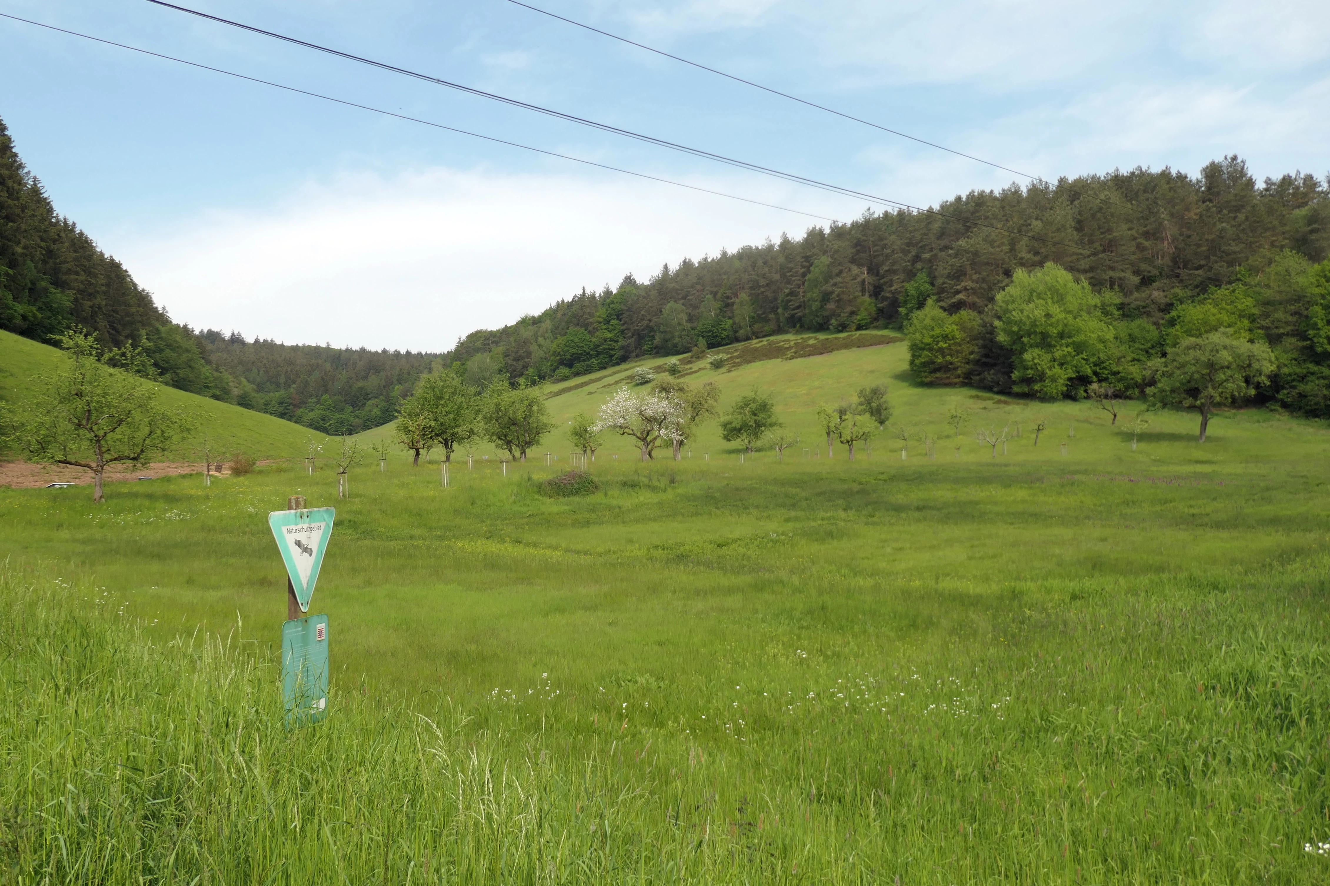
A wide landscape view of a green meadow in the Jakobsgrund nature reserve, with a triangular sign in the foreground, scattered trees, and a forested hillside in the background under a cloudy sky.
A view of the Jakobsgrund bei Gammelsbach nature reserve in the Odenwald, showcasing its characteristic meadows and hillside forest.

Jakobsgrund bei Gammelsbach history and protected-area timeline

Jakobsgrund bei Gammelsbach was officially designated as a nature reserve (Naturschutzgebiet) on 4 March 1996, recognising the long-standing ecological value of the meadow valley northwest of the village of Gammelsbach. Before formal protection, the area had been shaped by centuries of traditional, low-intensity agricultural use: hay-making, grazing, and the management of scattered orchard trees had created and maintained the open grassland habitats on which the site's botanical diversity depends.

In 2008 the reserve's status was elevated in practical terms when it became part of the larger FFH area "Jakobsgrund und Gammelsbachaue", joining the European Natura 2000 network. This integration connected the small national reserve to a wider landscape management framework, with mowing schedules and habitat measures now coordinated under the FFH management plan. The shift reflected a broader trend in German conservation toward embedding small, high-value nature reserves into larger landscape-scale protection schemes.

Jakobsgrund bei Gammelsbach landscape and geographic character

The landscape of Jakobsgrund bei Gammelsbach is shaped by the narrow, V-shaped valley of the Gammelsbach and its westward-opening side valley. The reserve occupies a tight stretch of valley floor and slope in the sandstone Odenwald, with elevations ranging from roughly 320 to 390 metres above sea level.

Slopes are steep and locally exposed, particularly on south-facing sections where sun and dryness create conditions more typical of open heaths than of central European forest. The valley floor is comparatively flat and damp, carved by the stream and softened by accumulated sediment and peat-like deposits. The contrast between the dry, sunlit slopes and the cool, humid valley bottom is one of the defining features of the scenery, and it produces the patchwork of habitats that makes the reserve unusual.
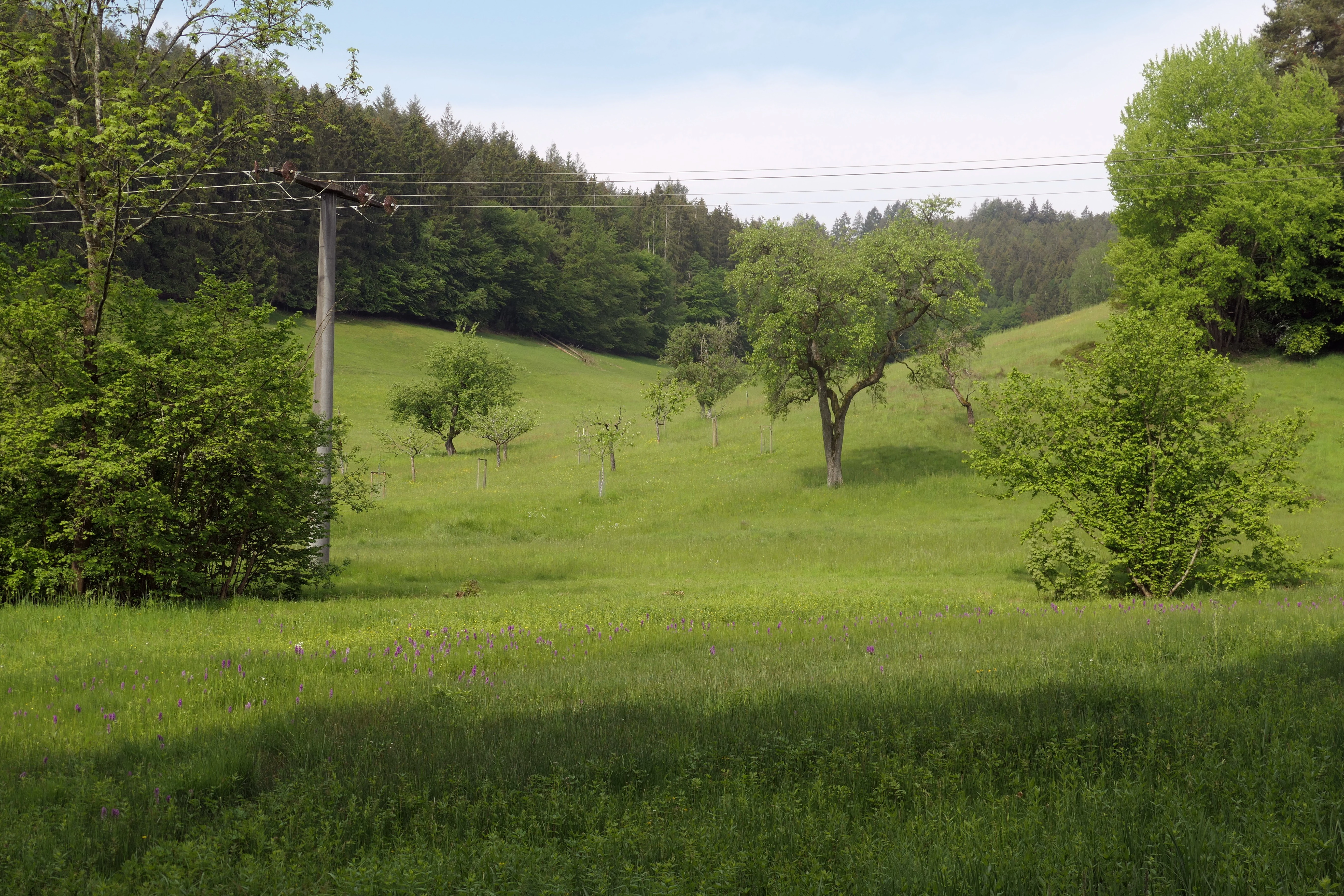
A green, hilly meadow with scattered fruit trees and a wooded hillside in the background. An old wooden power line pole stands on the left.
A view of the Jakobsgrund nature reserve, showing a meadow orchard nestled against forested slopes in the Odenwald.

Jakobsgrund bei Gammelsbach ecosystems, habitats, and plant life

Ecologically, Jakobsgrund bei Gammelsbach stands out because it preserves a remarkable variety of grassland communities compressed into a very small area. On dry, acidic, south-facing slopes, the vegetation is dominated by mat-grass swards (Borstgrasrasen) with elements of heath and broom heather, while neighbouring, slightly richer areas support poor meadow oatgrass (Glatthafer) meadows. The valley bottom, in contrast, is characterised by small sedge fens, wet meadows, and patches that approach low bog-like (Niedermoor) conditions.

Orchard meadows (Streuobstwiesen) along the valley sides add a further distinct habitat layer, linking traditional land use to biodiversity. The combination of dry and wet, poor and slightly richer, open and structurally complex habitats creates transitions that are rare in such a concentrated setting, and that sustain a diverse community of plants adapted to very different moisture and nutrient conditions. The site is a textbook example of the ecological richness produced by traditional small-scale farming in the sandstone Odenwald.

Jakobsgrund bei Gammelsbach wildlife and species highlights

The mosaic of habitats supports an unusually rich insect fauna. Warm, dry slopes host species such as the marbled white butterfly, the two-coloured bush cricket, and the wart-biter cricket, while the damp meadows along the stream are home to the large and small meadow ants' blue butterflies (Dunkler and Heller Wiesenknopf-Ameisenbläuling), whose larvae depend on specific ant species living in the wet meadow vegetation.

Birds also make use of the varied habitats: the red-backed shrike (Neuntöter) uses the dry, open slopes as a hunting territory, taking advantage of the abundant insect life. In wetter areas near the Gammelsbach, the common frog (Grasfrosch) is a typical resident of the damp meadows and the stream margins. The combination of flower-rich grasslands, scrub edges, heaths, and riparian zones supports pollinators, predatory insects, amphibians, and birdlife together within a very small footprint.

Jakobsgrund bei Gammelsbach conservation status and protection priorities

Conservation at Jakobsgrund bei Gammelsbach centres on maintaining the open, semi-natural grassland mosaic that has developed through long use of the valley. The reserve aims to protect rare plant and animal species associated with both dry habitats, such as mat-grass swards and heaths, and wet habitats, including small sedge fens and low bog-like mires. Orchards of traditional fruit trees form a third conservation priority, both for their biodiversity value and for the cultural landscape character they sustain.

Management focuses on extensive, low-intensity use of the meadows: no fertilisers or pesticides, late or carefully timed mowing, and grazing practices compatible with the conservation goals. Since 2008, these measures have been formally coordinated through the management plan of the FFH area "Jakobsgrund und Gammelsbachaue", aligning the small national nature reserve with broader European habitat protection objectives under the Natura 2000 network.

Jakobsgrund bei Gammelsbach cultural meaning and human context

The cultural dimension of Jakobsgrund bei Gammelsbach lies in the traditional rural landscape that surrounds and sustains it. The reserve's mosaic of orchards, hay meadows, and grazed slopes reflects centuries of small-scale farming in the Odenwald, where the interplay of village life, livestock, and wood pasture shaped a rich man-made landscape of high biodiversity.

The valley still carries traces of this heritage in its scattered traditional fruit trees, small fields, and stream-fed meadows. The persistence of these practices, alongside formal protection, is what gives the site not just ecological value but also a clear cultural-landscape identity rooted in the history of the Gammelsbach and Beerfelden communities.

Top sights and standout views in Jakobsgrund bei Gammelsbach

A small valley protected for an unusually dense mosaic of dry and wet grassland habitats in the sandstone Odenwald. Steep south-facing slopes with mat-grass and heaths sit directly alongside small sedge fens, wet meadows, and traditional orchards along the Gammelsbach stream.

The reserve supports rare plants such as white hyacinth orchid and marsh violet, harbours meadow ants' blue butterflies along its damp meadows, and provides hunting territory for red-backed shrikes on its drier slopes. Since 2008 it has been integrated into the European Natura 2000 network through the FFH site "Jakobsgrund und Gammelsbachaue".

Best time to visit Jakobsgrund bei Gammelsbach

The valley has a distinct seasonal character that reflects the different habitats it protects. Late spring and early summer are the most rewarding periods for wildflowers and orchids, when the wet meadows around the Gammelsbach come into bloom and plants such as white hyacinth orchid and marsh violet are visible. This period is also peak time for many of the butterflies and other insects that the reserve is known for.

Late summer and early autumn bring warmer, drier conditions that favour the insect communities on the south-facing slopes, including bush crickets and butterflies of dry habitats. Visits should generally be timed to coincide with mild, dry weather, since the valley bottom can be wet and muddy, and several of the most interesting habitats lie along the stream and its margins.


Monthly climate preview

Long term representative point measurements for monthly temperature and precipitation variation

Jakobsgrund bei Gammelsbach Climate Normals and Annual Temperature Rhythm

Jakobsgrund bei Gammelsbach records measured average temperatures ranging from near freezing to warm maximum thresholds alongside consistent daily precipitation patterns across the twelve month period. Reviewing the complete monthly climate dataset provides structured temperature norms and precipitation metrics for detailed regional analysis.
Annual mean10 °C
0 °C20 °C
Jan
Feb
Mar
Apr
May14°
Jun18°
Jul20°
Aug20°
Sep15°
Oct10°
Nov
Dec
Warmest month
July

20.3 °C

Coolest month
January

0.1 °C

Wettest month
July

2.4 mm/day

Driest month
April

1.5 mm/day

Park location guide

Geography guide, regional context, and park location map for Jakobsgrund bei Gammelsbach

Jakobsgrund bei Gammelsbach park geography, regions, and map view in Germany

Understand where Jakobsgrund bei Gammelsbach sits in Germany through a broader geographic reading of the surrounding landscape, nearby location context, and its mapped position within the national park landscape.

How Jakobsgrund bei Gammelsbach fits into Germany

Germany is a federal republic in Western and Central Europe with a population of over 83 million across sixteen constituent states. It is Europe's largest economy by nominal GDP and a major global exporter and importer. The capital is Berlin, and the country borders Denmark, Poland, Czech Republic, Austria, Switzerland, France, Luxembourg, Belgium, and the Netherlands.

Wider geography shaping Jakobsgrund bei Gammelsbach in Germany

Germany is located in Western and Central Europe, spanning 357,022 km². It borders Denmark to the north, Poland and the Czech Republic to the east, Austria and Switzerland to the south, and France, Luxembourg, Belgium, and the Netherlands to the west. The country has coastlines on the Baltic Sea and North Sea to the north, with the Alps located in the southern region.

Map view of Jakobsgrund bei Gammelsbach

Use this park location map to pinpoint Jakobsgrund bei Gammelsbach in Germany, understand its exact geographic position, and read its mapped placement within the surrounding landscape more clearly.

Pigeon | © OpenStreetMap contributors

Location context for Jakobsgrund bei Gammelsbach

Hesse

Visual exploration of grassland habitats, valley terrain, and conservation scenery in the Odenwald hills

Jakobsgrund bei Gammelsbach Landscape Photos and Protected Area Scenery

Visual documentation captures the fine-grained mosaic of dry mat-grass swards, wet meadows, and traditional orchards across the valley. Studying these protected-area photographs reveals the distinct topography and habitat diversity defining the reserve environment.

A wide landscape view of a green meadow in the Jakobsgrund nature reserve, with a triangular sign in the foreground, scattered trees, and a forested hillside in the background under a cloudy sky.

A green meadow with scattered orchard trees and a nature reserve sign in the foreground, with hills in the background.

A green, hilly meadow with scattered fruit trees and a wooded hillside in the background. An old wooden power line pole stands on the left.

Park atlas

Compare regional valley reserves and connected conservation areas across the Odenwald.

Parks Near Jakobsgrund bei Gammelsbach and Surrounding Protected Landscapes

Browsing other protected areas near Jakobsgrund bei Gammelsbach reveals how local sandstone valley habitats connect across the wider regional geography. Examining adjacent nature reserves provides broader context on regional grassland mosaics and stream valley ecosystems.
A soft, horizontal watercolor painting depicting a meandering stream flowing through green meadows and rolling hills under a pale sky.
Nature reserveHesse
About 5.3 km away#1 closest

Southwest

Finkenbachtal bei Finkenbach Nature Reserve: Mapped Brook Valleys of the Odenwald

Protected stream corridor and floodplain meadows in southern Hesse

Finkenbachtal bei Finkenbach preserves a compact, ecologically intact valley system characterized by meandering sandstone brook morphology and traditional floodplain meadow management. This protected area serves as a significant link in the regional Odenwald stream network, illustrating the intersection of low mountain forest and valley floor vegetation dynamics.

Area
0.276 km²
Established
1981
Relief
Upland
Climate
Temperate
Watercolor painting of soft, rolling green hills and meadows in a minimalist style, set against a light background.
Nature reserveHessen
About 7 km away#2 closest

West

Dürr-Ellenbachtal von Wald-Michelbach: Odenwald Nature Reserve and Protected Valley Geography

A historic meadow valley in Hessen, Germany

The Dürr-Ellenbachtal von Wald-Michelbach nature reserve protects an elongated, narrow valley framed by forested ridges in the central Odenwald. This area is defined by its meandering brook, diverse alder stands, and species-rich meadows that sustain significant local biodiversity. As a key Natura 2000 site, it serves as an essential example of protected meadow landscapes and rural mountain terrain within the Bergstraße district.

Area
0.542 km²
Established
1990
IUCN
IV
Relief
Mountain
A wide watercolor painting showing rolling green hills and trees with pale pink and yellow hues across a valley landscape.
Nature reserveHessen
About 9 km away#3 closest

Northwest

Rotes Wasser von Olfen Nature Reserve: Protected Wetland and Odenwald Geography

A unique bog and iron-rich stream landscape in Hessen, Germany.

Rotes Wasser von Olfen preserves a rare, small-scale mosaic of transitional bog and wet meadow vegetation within the Odenwald range. This protected site features reddish, iron-rich seepage waters and provides essential habitat for specialized flora and dragonfly populations amidst a surrounding forested mountain landscape.

Area
0.121 km²
Established
1980
IUCN
IV
Relief
Upland
A watercolor painting depicting a soft-focus, light-colored landscape of rolling green hills, clustered trees, and a gentle stream valley.
Nature reserveHessen
About 11 km away#4 closest

West

Eiterbachtal von Wald-Michelbach Nature Reserve in the Central Odenwald Uplands

A protected stream-valley landscape in the Bergstraße district of Hessen

Eiterbachtal von Wald-Michelbach protects a near-natural stream environment characterized by its meandering course, alder-ash gallery forests, and diverse tall-herb meadow communities. This nature reserve provides essential habitat in the southern Odenwald, showcasing the interplay between hydrological stream processes and sandstone forest edges within the Hessen region.

Area
0.473 km²
Established
1983
IUCN
IV
Relief
Upland
A horizontal watercolor illustration of a soft, rolling landscape with a central winding path or stream, green meadows, distant hills, and foreground trees and flowers.
Nature reserveHesse
About 12 km away#5 closest

Northwest

Gras-Ellenbacher Wiesen Nature Reserve: Protected Valley Basin Geography and Map Overview

Wet meadows and seepage habitats within the Odenwald hills

Situated in a gentle hollow near the Dachsberg and Kirchberg ridges, Gras-Ellenbacher Wiesen represents an essential Hessian nature reserve. This overview highlights the interplay between the Ulfenbach stream, drainage infrastructure, and traditional meadow management that defines this distinct sandstone upland protected landscape.

Area
0.241 km²
Established
1981
IUCN
IV
Relief
Upland
A horizontal watercolor painting showing rolling green hills, a winding stream in the foreground, and a single tree on the right.
Protected landscapeRhein-Neckar-Kreis
About 14 km away#6 closest

Southwest

Odenwald Protected Landscape: Geography and Regional Mapping in Rhein-Neckar-Kreis

Exploring the characteristic Odenwald mountain terrain and valley systems

This protected landscape encompasses over 6,000 hectares of diverse topography in northern Baden-Württemberg. The terrain features a classic Odenwald relief, defined by narrow V-shaped valley notches, riparian woodlands, and structural mosaics of forest and meadow. Gain insight into the geographic and ecological character of these protected stream catchments and ridgelines.

Area
60.775 km²
Established
1996
IUCN
V
Nature reserveHesse
About 14 km away#7 closest

West

In der Striet bei Vöckelsbach Nature Reserve: Regional Geography and Mapped Protected Landscapes

A compact forest and wetland mosaic in the Odenwald of southern Hesse

The nature reserve In der Striet bei Vöckelsbach is an essential protected area covering four and a half hectares of valley floor. It provides a dense habitat gradient from reeded spring zones through alder forests to mixed deciduous slopes. This record details the park landscape, stream systems, and its integration into the larger Geo Naturpark Bergstraße Odenwald and Natura 2000 protected areas.

Area
0.048 km²
Established
1988
A wide watercolor illustration showing a river curving through a grassy valley with trees and hills in the background.
Nature reserveHessen
About 16 km away#8 closest

West

In der Erbach bei Mörlenbach Nature Reserve: Protected Odenwald Stream Valley

Regional geography and habitat mapping in southern Hessen

The In der Erbach bei Mörlenbach nature reserve preserves a well-defined side-valley ecosystem within the broader Odenwald landscape. Its protected boundaries encompass a moisture-rich corridor featuring wet meadows, reedbeds, and forest edges that exemplify the traditional cultural geography of the Weschnitz river basin in southern Germany.

Area
0.197 km²
Established
1997
IUCN
IV
Relief
Upland

Common questions about visiting, size, designation, and location context for Jakobsgrund bei Gammelsbach

Jakobsgrund bei Gammelsbach FAQs for park facts, access, geography, and protected area context

Find quick answers about Jakobsgrund bei Gammelsbach, including protected-area facts, park geography, trail and visitor context, and how the park fits into its surrounding country and regional landscape.
MoriAtlas Explorer

Continue Your Protected Areas Search Across the Global Atlas

Deepen your exploration by continuing the structured search for national parks and protected areas worldwide. Utilize the comprehensive filtering capabilities to compare different conservation landscapes and refine your understanding of global park geography. Discover more about the distribution and characteristics of protected natural areas.

Global natural geography