Mori Atlas logo
Nature reserveJaluit Atoll

A vast coral atoll ecosystem defined by an expansive interior lagoon and diverse motu clusters.

Jaluit Atoll Nature Reserve: Mapping the Protected Marine Landscapes of the Marshall Islands

(Jaluit Atoll Conservation Area)

Jaluit Atoll represents a significant conservation landscape in the Marshall Islands, encompassing a vast coral atoll with 91 distinct islets encircling an immense interior lagoon. Located within the Ralik Chain, this protected area serves as a critical wetland environment with diverse marine habitats and significant historical layers. The geography highlights the fragile transition between exposed Pacific reef flats and sheltered lagoon waters that support ongoing local community life.

coral atollPacific atollRamsar wetlandlagoon ecosystemRalik ChainMarshall Islands

Jaluit Atoll

Nature reserve

Park overview

Structured park overview, official facts, and landscape profile for Jaluit Atoll

Jaluit Atoll park facts, protected area profile, and essential visitor context

Review the core facts for Jaluit Atoll, including designation, size, terrain, visitor scale, habitats, and operating context in one park-focused overview.

About Jaluit Atoll

Jaluit Atoll is a defining feature of the Ralik Chain and one of the most historically significant atolls in the Republic of the Marshall Islands. Its structure is classic for a large Pacific coral atoll: a ring of 91 small islets surrounding a deep central lagoon. Although the combined land area is modest, the enclosed lagoon is vast, creating a mosaic of reef, lagoon, and islet environments that support distinctive marine and coastal ecosystems.

The atoll has long played an outsized role in the political life of the Marshall Islands. It served as the principal administrative seat during the German colonial period and again under Japanese mandate, and was a major military hub during World War II. After the war it formed part of the Trust Territory of the Pacific Islands under United States administration until Marshallese independence. Remnants of these eras, from German-era infrastructure to Japanese garrison ruins and wartime battle damage, remain visible on several islets.

Modern Jaluit is a working community as well as a conservation landscape. The islet of Jabor functions as the main population center, hosting small commercial services, schools, and access points for fishing and snorkeling within the lagoon. At the same time, the atoll's lagoon has been formally protected as the Jaluit Atoll Conservation Area and designated internationally as a Ramsar Wetland, reflecting both the ecological richness of the system and its importance within Micronesian marine conservation.

Quick facts and research context for Jaluit Atoll

Jaluit Atoll lies in the Ralik Chain of the western Marshall Islands and forms a legislative district of the Republic of the Marshall Islands. The atoll comprises 91 islands enclosing a large lagoon, with a comparatively small total land area dominated by the main islet of Jaluit itself. It sits about 220 kilometers southwest of Majuro, the national capital.

The atoll was historically the administrative center of the Marshall Islands, first as a German colonial seat and later under Japanese mandate and American trusteeship. Today it is both a populated community and a protected area: its lagoon is designated as the Jaluit Atoll Conservation Area, recognized as a Ramsar Wetland in recognition of its ecological importance.

Protection and recognition

Examining documented designation history and Ramsar site recognition

Jaluit Atoll Protection Status and International Recognition Records

Jaluit Atoll holds a documented mixed protection status established in 2004 alongside official Ramsar wetland recognition. Structured records detail the historical designation framework and international recognition sources associated with the conservation area.

International recognition

Protection details

Protection scope
Mixed
Designated year
2004
Transboundary protection
No
Park context

Deeper park guide and search-rich context for Jaluit Atoll

Jaluit Atoll history, landscape, wildlife, and travel context

Explore Jaluit Atoll through its history, landscape character, ecosystems, wildlife, conservation priorities, cultural context, and seasonal travel timing in a structured park guide built for atlas discovery and search intent.

Why Jaluit Atoll stands out

Jaluit Atoll is best known for its scale and structure as a Pacific coral atoll, with an enormous lagoon encircled by dozens of small islets. Its international recognition as a Ramsar site underscores the ecological value of these lagoon and reef habitats. The atoll is also strongly associated with its layered imperial and wartime history. German colonial administration, the Japanese South Seas Mandate, intensive World War II military activity, and the subsequent American trusteeship all left physical and cultural traces across the islands, making Jaluit a place where Pacific political and military history is closely interwoven with a living Marshallese community and a protected marine environment.
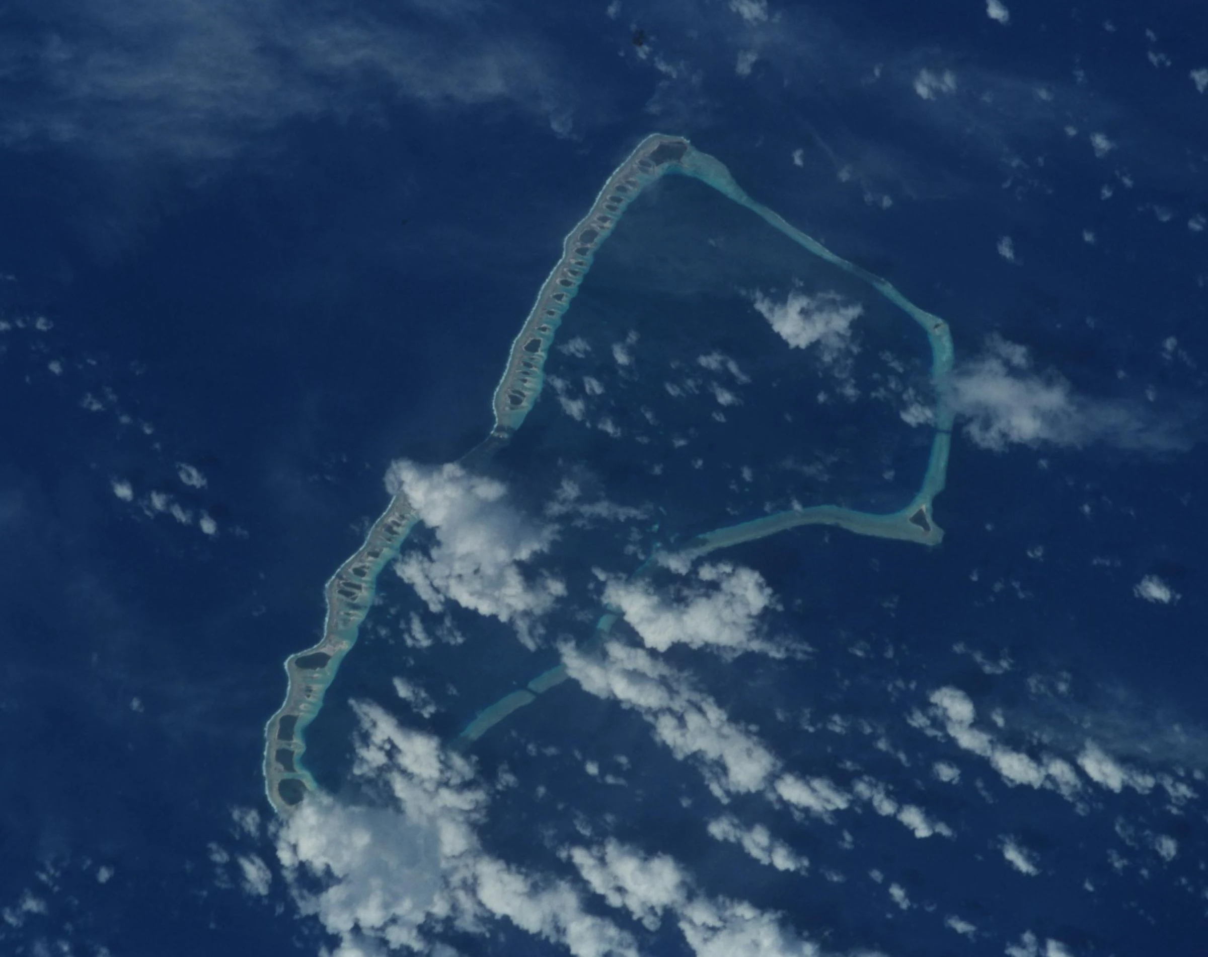
An aerial satellite photograph of Jaluit Atoll, showing a ring of coral islets surrounded by the deep blue Pacific Ocean with scattered white clouds.
Satellite view of Jaluit Atoll in the Marshall Islands, capturing the reef structure and surrounding ocean.

Jaluit Atoll history and protected-area timeline

Jaluit Atoll has a layered history shaped by successive colonial powers and global conflict. The British merchant vessel Rolla, sailing between Australia and China, sighted the atoll in 1803, marking one of the earliest documented European encounters with the islands. In 1885 the German Empire annexed the Marshall Islands and made Jaluit the colonial administrative seat. Between 1888 and 1906 the territory was administered by the Jaluit Company on Germany's behalf, with a succession of imperial commissars overseeing governance, trade, and imperial infrastructure.

After World War I, Jaluit became part of the South Seas Mandate under the Empire of Japan and functioned as the headquarters of Japanese administration over the Marshall Islands. The Japanese population grew to several hundred by the 1930s, and the atoll was heavily militarized. By World War II the garrison included more than 1,500 Imperial Japanese Navy personnel and several hundred Imperial Japanese Army troops. U.S. forces bombed the island repeatedly in late 1943, and after the war Jaluit was incorporated into the broader U.S. Naval Base Marshall Islands.

From 1947 onward Jaluit was part of the Trust Territory of the Pacific Islands under United States administration, a status that lasted until Marshallese independence in 1986. During this period the atoll also took in some of the communities displaced from Bikini Atoll by U.S. nuclear testing; several families relocated temporarily to Jaluit to produce copra, though typhoons in 1957 and 1958 damaged homes and supply infrastructure. Independent Marshall Islands governance was formally established in 1986, after which Jaluit resumed its place as a legislative district with a renewed focus on local culture, marine resources, and conservation.

Jaluit Atoll landscape and geographic character

Jaluit Atoll presents the dramatic visual contrast typical of large Pacific coral atolls: a thin chain of low, vegetation-covered islets surrounding an immense interior lagoon. The shape of the lagoon is often described as roughly kite-like, curving in an elongated form framed by the encircling reef and motu. With 91 islets and only about 11 square kilometers of total dry land, Jaluit illustrates how a coral atoll's geography is dominated by water rather than by solid ground.

The islets vary in size and character. The largest islet, simply called Jaluit, holds most of the atoll's land area, while other islets such as Jabor and Imiej host settlements, infrastructure, or historical ruins. Elevations across the atoll are uniformly low, with the highest point only a few meters above sea level, underscoring the atoll's vulnerability to coastal change and extreme weather. The reef rim defines the boundary between the open ocean and the sheltered lagoon, producing distinct seascapes on either side, from exposed reef flats to quiet lagoon waters and white-sand motu beaches.

Jaluit Atoll ecosystems, habitats, and plant life

Jaluit's natural environment is defined by the interplay between coral reef, lagoon, and low-lying islet habitats. The encircling reef supports the structural basis of the entire atoll, while the enclosed lagoon of nearly 700 square kilometers creates an unusual sheltered marine environment with its own circulation, sediment patterns, and biological communities. These habitats together provide nurseries and feeding grounds for a wide variety of reef and pelagic species.

Vegetation on the islets reflects typical Marshallese atoll flora: coastal strands of salt-tolerant shrubs and trees, mixed with breadfruit, coconut, and other useful species that have long been cultivated by islanders. Wetlands and shallow lagoon margins add further habitat complexity, contributing to the atoll's recognition under the Ramsar Convention. The combination of reef, lagoon, islet forest, and coastal wetland gives Jaluit a layered ecological character unusual for such a small total land area, and it is this integrated system that the Jaluit Atoll Conservation Area is designed to protect.

Jaluit Atoll wildlife and species highlights

The atoll's wildlife story is essentially a marine one, centered on the productivity of its reef and lagoon systems. Coral communities along the reef rim support reef-associated fish, invertebrates, and the broader food web that extends into the lagoon. Shark and ray species, larger pelagic fish, and migratory species all use the lagoon and adjacent ocean, making Jaluit a recognized area for both subsistence and sport fishing.

On land, birdlife and coastal species occupy the narrow habitats available across the motu. Seabirds and shorebirds are typical inhabitants of Pacific atolls of this kind, using both the beaches and the interior vegetation of the islets. The combination of reef, lagoon, and islet habitats means that the atoll's ecological value lies less in terrestrial species richness and more in the integrity of the marine and coastal systems that the Ramsar designation is intended to safeguard.

Jaluit Atoll conservation status and protection priorities

Conservation is central to Jaluit's modern identity. The atoll's lagoon was formally protected as the Jaluit Atoll Conservation Area and, in 2004, designated under the Ramsar Convention as a wetland of international importance, placing it within a global network of significant wetland sites. This designation reflects the ecological value of the coral reef, the lagoon, and the associated coastal habitats, all of which are vulnerable to climate change, shifting weather patterns, and local resource pressures.

Recognition as a Ramsar site also reflects the links between conservation, traditional Marshallese use of marine resources, and contemporary livelihoods centered on fishing. The atoll is not preserved as an uninhabited reserve but as a working seascape in which conservation planning interacts with the everyday lives of the Jaluit community, including those based on Jabor and the smaller islets.

Jaluit Atoll cultural meaning and human context

Jaluit's cultural landscape is inseparable from its administrative and military history. As the colonial seat of the German and later Japanese administrations, the atoll hosted significant foreign communities and institutions, and relics from those periods, including the ruins of Japanese power stations, barracks, antiaircraft guns, and a Shinto shrine on Imiej, remain part of the visible heritage of the islands.

Today the atoll is a center of contemporary Marshallese life in the Ralik Chain. Jabor serves as a hub for shopping, education, and inter-islet travel, while schools across several islets, including Jaluit High School, a boarding school serving the southern atolls, anchor community life. Religious institutions, notably the Catholic presence in Jabor with St. Joseph's School, also play a central role. The combination of surviving colonial and wartime infrastructure with active Marshallese community life gives Jaluit a distinctive cultural texture among Micronesian atolls.

Top sights and standout views in Jaluit Atoll

Jaluit Atoll's standout features include its sheer scale as a coral atoll, with 91 islets encircling one of the larger lagoons in the Marshall Islands, and its international recognition as a Ramsar Wetland through the Jaluit Atoll Conservation Area. Its depth of imperial and wartime history, ranging from German colonial administration to Japanese mandate governance and major World War II military operations, gives it a layered human story rarely matched in the region.

Equally important is the way the atoll continues to function as a living community. Jabor's role as the main population center, the ongoing operation of Jaluit High School as a regional boarding school, and the integration of conservation with everyday atoll life make Jaluit a place where ecological significance, historical depth, and active Marshallese culture meet.

Best time to visit Jaluit Atoll

Like other atolls in the Marshall Islands, Jaluit has a tropical maritime climate shaped by wet and drier seasonal patterns rather than by dramatic temperature change. Periods of calmer seas and reduced rainfall generally offer more comfortable conditions for inter-islet boating, snorkeling around the reef, and exploring sites such as the wartime ruins on Imiej. The lagoon and reef environments can be appreciated year-round, but drier windows tend to provide the most reliable outdoor experience.

Visitors interested in history may find it valuable to plan around conditions that allow boat trips between Jabor, Imiej, and other islets, since the wartime and colonial sites are spread across the atoll. As with any low-lying Pacific atoll, conditions can shift quickly with weather systems, so flexibility and local guidance are essential to making the most of a visit.
Monthly climate preview

Examine long-term representative temperature ranges and monthly precipitation patterns across the year

Jaluit Atoll Climate Normals: Annual Temperature and Precipitation Rhythm

Jaluit Atoll sustains consistent mean temperatures near twenty-eight degrees celsius alongside measured monthly precipitation values ranging from five to nine millimeters per day. Reviewing the complete twelve-month profile reveals detailed baseline climate normals recorded across historical observation periods.
Annual mean28 °C
28 °C28 °C
Jan28°
Feb28°
Mar28°
Apr28°
May28°
Jun28°
Jul28°
Aug28°
Sep28°
Oct28°
Nov28°
Dec28°
Warmest month
December

28.3 °C

Coolest month
February

28 °C

Wettest month
April

9.3 mm/day

Driest month
February

5.8 mm/day

Park location guide

Geography guide, regional context, and park location map for Jaluit Atoll

Jaluit Atoll park geography, regions, and map view in Marshall Islands

Understand where Jaluit Atoll sits in Marshall Islands through a broader geographic reading of the surrounding landscape, nearby location context, and its mapped position within the national park landscape.

How Jaluit Atoll fits into Marshall Islands

The Marshall Islands is a sovereign island nation in Oceania, located in the Micronesia region of the Northwestern Pacific Ocean. The territory consists of 29 coral atolls and five main islands plus over 1,200 very small ones, divided across two island chains: Ratak in the east and Ralik in the west. The country gained independence from the United States in 1979 and maintains a Compact of Free Association with the US. It is notable for having the highest proportion of water to land of any sovereign state, at 98.62%.

Wider geography shaping Jaluit Atoll in Marshall Islands

The Marshall Islands is located in the Micronesia region of the Northwestern Pacific Ocean, west of the International Date Line and north of the equator. The territory is composed of 29 coral atolls and five main islands, plus approximately 1,220 very small islets, divided into two island chains: Ratak (eastern) and Ralik (western). Maritime boundaries are shared with Wake Island to the north, Kiribati to the southeast, Nauru to the south, and the Federated States of Micronesia to the west.

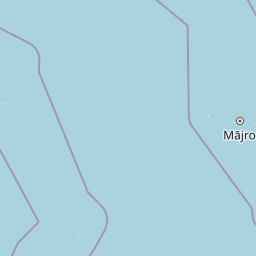
Map view of Jaluit Atoll

Use this park location map to pinpoint Jaluit Atoll in Marshall Islands, understand its exact geographic position, and read its mapped placement within the surrounding landscape more clearly.

Pigeon | © OpenStreetMap contributors

Visualizing the coral atolls, expansive lagoons, and protected habitats of the Marshall Islands

Jaluit Atoll Photos and Protected Landscape Imagery

Visual documentation of Jaluit Atoll reveals the intricate geography of low coral islets encircling a vast marine lagoon. Examining these protected area photographs provides clear insight into the fragile coastal environments and unique terrain defining the region.

An aerial satellite photograph of Jaluit Atoll, showing a ring of coral islets surrounded by the deep blue Pacific Ocean with scattered white clouds.

Park atlas

Compare surrounding regional geography and connected coral reef reserves

Explore Protected Areas and Other Parks Near Jaluit Atoll

Browse regional protected areas and wetland habitats connected to the wider Pacific island ecosystem. Compare lagoon geographies and conservation landscapes across the surrounding island chain.
Protected areaMarshall Islands
About 172 km away#1 closest

West

Namdrik Atoll Protected Area: Geography and Coastal Ecosystems in the Marshall Islands

A remote Ramsar-recognized coral atoll and marine wetland.

Namdrik Atoll is a distinctive coral atoll within the Ralik Chain of the Marshall Islands, recognized for its exceptional mangrove forests and protected marine ecosystems. This area consists of two wooded islands enclosing a large lagoon without navigable passes, creating an isolated habitat for sea turtles and diverse reef life. Explore the geography of this small, ecologically significant protected land that represents the unique environmental character of the central Pacific.

Area
2.8 km²
Established
2012
Relief
Lowland
Climate
Tropical
A watercolor painting showing a panoramic view of soft, green rolling hills, a cluster of trees, and a calm water surface in a light, muted palette.
Protected areaMarshall Islands
About 231 km away#2 closest

Northeast

Majuro: Mapping the Protected Coral Atoll Landscapes and Island Geography of the Marshall Islands

Regional atoll atlas and protected lagoon geography.

Majuro serves as the primary administrative and geographic anchor within the Marshall Islands. This detailed mapping showcases the atoll's signature structure, characterized by 64 narrow islets enclosing a massive, sheltered 295 square kilometer lagoon. Delve into the specific landforms and regional marine geography that define this Pacific protected environment.

Area
9.7 km²
Relief
Lowland
Climate
Tropical
Access
Moderate access
Protected areaMarshall Islands
About 253 km away#3 closest

East

Mili Atoll Protected Area: Geographic Boundaries and Marshall Islands Landscape Context

Mapped coral atoll terrain in the Ratak Chain

Mili Atoll represents a complex protected landscape in the central Pacific, defined by its massive lagoon and distributed ring of 92 islets. Gain a deeper understanding of its physical geography, including tidal reef flats, low-lying coral formations, and the enduring historical artifacts that shape the contemporary environment of this significant Marshall Islands site.

Area
14.9 km²
Relief
Lowland
Climate
Tropical
Access
Remote access
Protected areaMarshall Islands
About 261 km away#4 closest

Northeast

Arno Atoll: A Rare Triple Lagoon Coral Protected Area in the Marshall Islands

Mapped geography and hydrological landscape context

Arno Atoll stands out as a unique geographic entity in the Ratak Chain with its triple lagoon configuration. Spanning 133 islands in the North Pacific, this protected area offers insight into atoll reef systems, low lying coral landscapes, and the environmental framework of the Marshall Islands.

Area
13 km²
Relief
Lowland
Climate
Tropical
Scope
Mixed
A pale, soft watercolor illustration depicting distant islands or atoll ridges across a calm lagoon, with silhouetted palm trees in the foreground on the left and right.
Protected areaMarshall Islands
About 374 km away#5 closest

Northwest

Kwajalein Atoll Protected Area and Marshall Islands Geographic Landscape Mapping

Pacific coral atoll structure and lagoon geography

Kwajalein Atoll represents a mature coral formation encompassing an immense lagoon within the Ralik Chain. The landscape consists of low-lying islets and interconnected reef structures that define the maritime geography of the Marshall Islands. This assessment provides a focus on the structural, mapped, and physical attributes that distinguish this protected site within the wider Pacific regional context.

Area
16.4 km²
Relief
Lowland
Climate
Tropical
Access
Highly restricted
Watercolor painting of a landscape showing a body of water surrounded by green land with trees and distant hills, with soft pink and purple washes on the sides
Protected areaMarshall Islands
About 444 km away#6 closest

North

Likiep Atoll: A Mapped Protected Area in the Marshall Islands Ratak Chain

Coral atoll geography and historical colonial landscape features

Likiep Atoll consists of 65 islands encircling a 424 square kilometer lagoon. As a protected area in the Marshall Islands, it offers insight into low lying atoll topography, unique marine environments, and the cultural remnants of successive colonial administrations.

Area
10.26 km²
Relief
Lowland
Climate
Tropical
Access
Remote access
Protected areaMarshall Islands
About 488 km away#7 closest

North

Ailuk Atoll Protected Area: Geography and Mapped Coral Landscapes in the Marshall Islands

Pacific atoll terrain, lagoon systems, and island geography

Study the geographic composition of Ailuk Atoll, featuring its classic ring of coral islets, deep-water reef passes, and vast central lagoon. This protected area offers insight into the subsidence-driven formation of Marshallese island chains and the enduring human reliance on traditional maritime navigation within a fragile Pacific ecosystem.

Area
5.4 km²
Relief
Lowland
Climate
Tropical
Access
Remote access
Protected areaMarshall Islands
About 645 km away#8 closest

North

Rongerik Atoll Protected Area: Mapping the Marshall Islands Coral Landscape

Remote coral atoll geography and lagoon structures in the Ralik Chain.

Rongerik Atoll presents a textbook example of Pacific atoll geography, where a cluster of small islets encloses an expansive lagoon. As a protected area located in the remote Marshall Islands, this site serves as a vital point of study for understanding coral reef systems and the isolated island terrain of the Ralik Chain. The landscape provides clear insights into the physical contrast between narrow coral landmasses and the deep interior waters characteristic of the region.

Area
1.68 km²
Relief
Lowland
Climate
Tropical
Access
Remote access

Common questions about visiting, size, designation, and location context for Jaluit Atoll

Jaluit Atoll FAQs for park facts, access, geography, and protected area context

Find quick answers about Jaluit Atoll, including protected-area facts, park geography, trail and visitor context, and how the park fits into its surrounding country and regional landscape.
MoriAtlas Explorer

Continue Your Protected Areas Search Across the Global Atlas

Deepen your exploration by continuing the structured search for national parks and protected areas worldwide. Utilize the comprehensive filtering capabilities to compare different conservation landscapes and refine your understanding of global park geography. Discover more about the distribution and characteristics of protected natural areas.

Global natural geography