

Mori Atlas logo
Nature reserveJestädter Weinberg

Tracing the Zechstein cliffs, calcareous grasslands, and Werra river valley mosaic.

Jestädter Weinberg Nature Reserve: A Geological and Ecological Landmark in Werra-Meißner-Kreis

Jestädter Weinberg stands as a significant protected area within the Werra-Meißner-Kreis district of northern Hesse, Germany. This nature reserve reveals a near-complete Zechstein geological profile, where reef-like dolomite cliffs rise sharply above the Werra river floodplain. The landscape encompasses a rare mosaic of dry calcareous grasslands, historic terraced vineyard remnants, and wetland habitats that support a high concentration of butterfly and dragonfly species.

dry grasslandcalcareous grasslandorchidsbutterfliesdragonfliesdolomite cliffs

Jestädter Weinberg

Nature reserve

Park overview

Structured park overview, official facts, and landscape profile for Jestädter Weinberg

Jestädter Weinberg park facts, protected area profile, and essential visitor context

Review the core facts for Jestädter Weinberg, including designation, size, terrain, visitor scale, habitats, and operating context in one park-focused overview.

About Jestädter Weinberg

Jestädter Weinberg is a compact but ecologically dense protected area along the Werra river in northern Hesse, Germany. Geologically, it sits at the eastern edge of a Palaeozoic uplift that is interpreted as a relict of the earlier continuous Variscan mountain belt linking the Rhenish Slate Mountains with the Harz. Within this small area, the right Werra valley side exposes an almost complete sequence of the Zechstein formation, from the underlying Devonian slate through Zechstein conglomerate, copper shale, the wall-like Zechsteinkalk and the older Gypsum, up to the reef-like Hauptdolomit cliffs that give the Weinberg its striking silhouette.

Ecologically, the reserve combines three clearly distinct landscape complexes. The sunny south-facing slope of the Weinberg itself is a hotspot of dry calcareous grassland with juniper scrub, rock-steppe vegetation and orchid-rich flora that qualifies as a priority habitat under the EU Habitats Directive. The neighbouring wooded west slope of the Fürstenstein, including the historic Burg Fürstenstein, preserves old pasture oaks, spring geophytes such as corydalis and wild garlic, and the structural elements of a near-natural light woodland. The Werra floodplain, with the artificial Jestädter See formed from former gravel excavation, adds aquatic and riparian habitats for waterbirds, dragonflies and riverine plants.

The protected area is part of the Geo-Naturpark Frau-Holle-Land and is administratively split between the Meinhard village of Jestädt and the Eschwege district of Albungen. It was one of the earliest rock-and-flora protection sites in the region, with successive protective designations in 1924, 1937 and 1978, and was incorporated into the Natura 2000 network in 2008. Today it functions less as a major visitor attraction and more as a quietly significant conservation site, valued for its geology, its dry grassland biodiversity and its role as a stepping stone in the Werra valley's protected-area network.

Quick facts and research context for Jestädter Weinberg

Jestädter Weinberg lies west of the village of Jestädt in the Werra-Meißner-Kreis of northern Hesse, at the exit of the Eschweger Becken where the Werra river turns northward. The reserve sits between 150 and 200 metres of elevation and is located inside the Geo-Naturpark Frau-Holle-Land, within the natural region of the Unteres Werrabergland.

The protected area covers roughly 60 hectares on the right Werra bank and was first protected in 1924. It has carried formal nature reserve status since 1978 under the national code 1636008 and the World Database on Protected Areas identifier 82016. Since 2008, it forms part of the broader 87-hectare Natura 2000 site "Jestädter Weinberg / Werraaltarm und -aue bei Albungen". The management focus is on Species and Habitat Management Area (IUCN Category IV), combining rock, grassland and floodplain protection.

Protection and recognition

Examine the official designation history and terrestrial conservation framework for Jestädter Weinberg.

Jestädter Weinberg Protection Status and International Recognition Records

Documented protection history for Jestädter Weinberg outlines terrestrial conservation measures established in 1937 within the global database. Official records verify management scope and administrative recognition parameters for the protected area.

Protection details

Protection scope
Terrestrial
Designated year
1937
Transboundary protection
No
WDPA ID
82016
Park context

Deeper park guide and search-rich context for Jestädter Weinberg

Jestädter Weinberg history, landscape, wildlife, and travel context

Explore Jestädter Weinberg through its history, landscape character, ecosystems, wildlife, conservation priorities, cultural context, and seasonal travel timing in a structured park guide built for atlas discovery and search intent.

Why Jestädter Weinberg stands out

The reserve is best known for its near-complete geological profile of the Zechstein formation, with reef-like Hauptdolomit cliffs whose cavernous, weathered surfaces dominate the ridge above the Werra. It also stands out for its calcareous dry grasslands, where warmth-loving orchid species such as twayblade, military orchid, fly orchid and bee orchid grow alongside juniper stands and a remarkable assemblage of 36 butterfly and burnet moth species. Equally distinctive is the cultural-natural overlap: this is a former vineyard hill, where wine was cultivated for centuries until the late 18th century and finally abandoned after the arrival of downy mildew in the 1870s. Relict grapevines, mulberry trees planted in the 1930s for silkworm breeding, and surviving garden herbs such as hyssop, rue, houseleek and blue iris still mark the long human imprint on this otherwise wild-looking landscape.
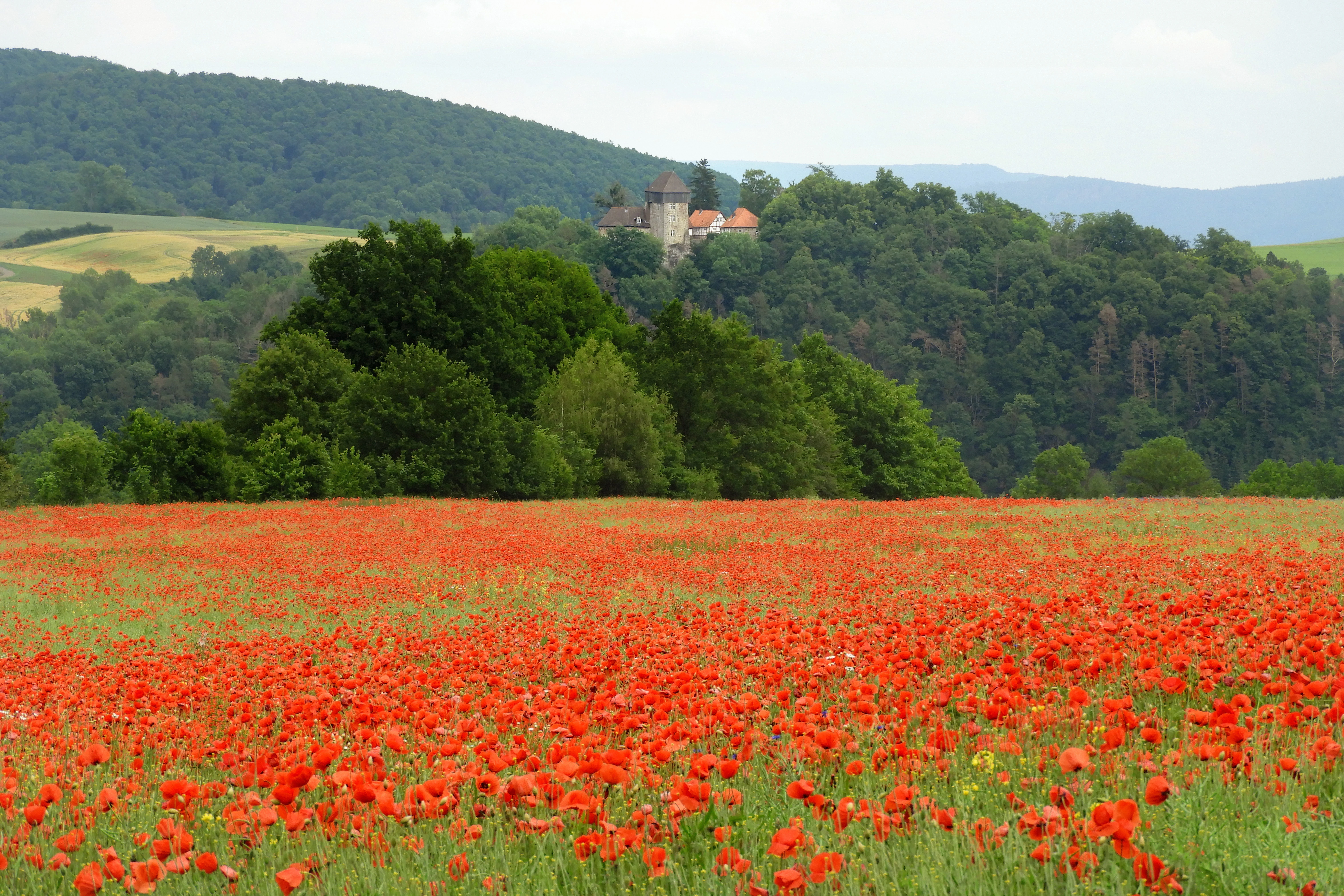
A wide landscape view showing a large field of red poppies in the foreground, a line of green trees in the midground, and a forested hill with a castle structure on top in the background under an overcast sky.
A field of red poppies stretches towards a forested hill topped by the Fürstenstein castle in the Jestädter Weinberg nature reserve.

Jestädter Weinberg history and protected-area timeline

The history of protection at Jestädter Weinberg extends over more than a century. In 1924, a regional ordinance in the Regierungsbezirk Kassel first safeguarded all rock formations on the Weinberg and on the west slope of the Fürstenstein due to their geological and botanical significance. In October 1937, the Zechstein formations were designated a flächenhaftes Naturdenkmal, an area-type natural monument.

The decisive protection step came on 3 October 1978, when the Bezirksdirektion für Forsten und Naturschutz at the Regierungspräsidium Kassel issued a formal nature reserve ordinance under the still-operative 1935 Reichsnaturschutzgesetz. The reserve, with national number 1636008 and WDPA code 82016, covers the valley slopes of the Weinberg and Fürstenstein, an adjacent Werra floodplain reach including a former gravel pit, and a stretch of the Werra itself, while allowing limited traditional agricultural, forestry and fishing use.

A new chapter began with the EU Habitats Directive. In April 1999, Hesse notified the European Commission of the combined site "Jestädter Weinberg / Werraaltarm und Werraaue bei Albungen" for the Natura 2000 network, citing the site's statewide importance for rare and threatened plant and animal species and as a breeding, resting and foraging biotope for numerous bird species. The site received its formal Natura 2000 designation through the Hessian Natura 2000 ordinance of January 2008 under site number 4624-303 and WDPA code 555520065.

Alongside this official conservation history runs a parallel cultural history of viticulture. The warm south-facing slope offered one of the most favourable vineyard sites in the Werra region. Wine is believed to have been grown on the hill since the first millennium CE, and eight winzers are documented as resident in Jestädt in 1738. Viticulture collapsed in the late 18th century and was finally abandoned after the American-borne downy mildew disease arrived in the 1870s. Surviving grapevines, mulberry trees from 1930s silkworm experiments and old fruit-tree plantings are now treated as relicts embedded in a protected landscape rather than as a working agricultural resource.

Jestädter Weinberg landscape and geographic character

The landscape of Jestädter Weinberg is shaped by the contrast between the steep, rocky right bank of the Werra and the flat river floodplain below. At the exit of the wide Eschweger Becken, the Werra enters a narrowed valley section and bends north, exposing a near-complete geological profile along the valley side. The Devonian slate at the base of the Fürstenstein and the western foot of the Weinberg is overlain discordantly by Zechstein conglomerate, copper shale and a wall-like Zechsteinkalk, then by older Gypsum layers and, finally, by the reef-like Hauptdolomit cliffs that dominate the skyline of the Weinberg.

The south-facing slope itself is steep, rocky and sun-exposed, with extreme microclimatic conditions featuring large daily and annual temperature swings. Above and below the cliffs the terrain opens into terraced relict vineyard land, dry grassland, juniper stands and light scrub. Across the river to the west rise the wooded slopes of the Soodener Bergland, while to the east the landscape flattens into the southern Gobert foreland. The narrow Werra floodplain with its willow thickets, reed beds and gravel-pit lake closes off the protected area along the river.

The view of the Weinberg from the Werra valley is shaped primarily by the pitted, cavernous dolomite surfaces of the Hauptdolomit cliffs. Locally, the Weinberg and Fürstenstein read as a single geomorphological unit, with the smaller, lower Fürstenstein ridge to the north acting as a wooded counterpart to the open, rocky Weinberg further south.
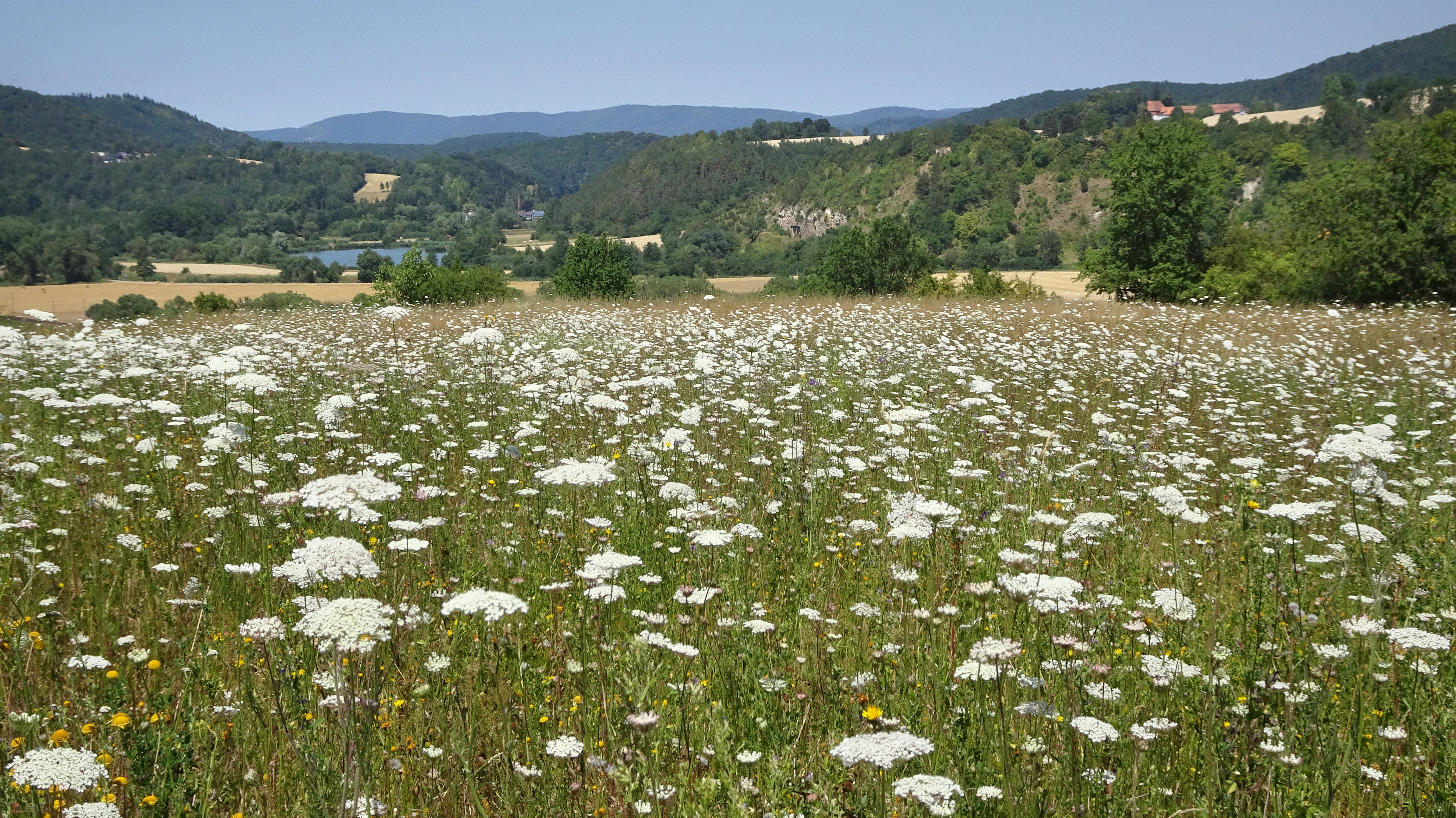
A wide landscape photograph showing a field of white wildflowers in the foreground, leading to a river valley with green trees, fields, and rolling forested hills under a clear blue sky.
A meadow of white wildflowers in the Jestädter Weinberg nature reserve, with the Werra river valley and forested hills in the background.

Jestädter Weinberg ecosystems, habitats, and plant life

The nature reserve is unusual in the density of habitat types compressed into a small area. On the Weinberg itself, the dominant habitats are dry calcareous grasslands on calcareous substrate, juniper scrub on formerly grazed dry grassland, open rock vegetation on the dolomite cliff faces, hedge structures along former garden and orchard boundaries, and small woodland patches. These open, flower-rich structures are recognised as priority habitats under the EU Habitats Directive.

The west slope of the Fürstenstein carries a different ecological character: a near-natural, structurally rich light woodland with old pasture oaks, standing and lying deadwood, and a notable spring flora of corydalis and wild garlic. The guiding image under the Habitats Directive for this forest community is the long-term protection of these structural elements and of typical tree species in their various developmental stages.

In the floodplain, the habitat mosaic shifts to riverine willow thickets, tall herb stands assigned to the "Feuchte Hochstaudenfluren an Gewässerufern" habitat type, reed communities with common reed and reed-canary grass, and the artificial Jestädter See. This lake, a relic of gravel extraction, is shadowed by the northern boundary embankment of the Bebra-Göttingen railway line, built in the 1870s, and now provides the principal still-water habitat within the protected area.
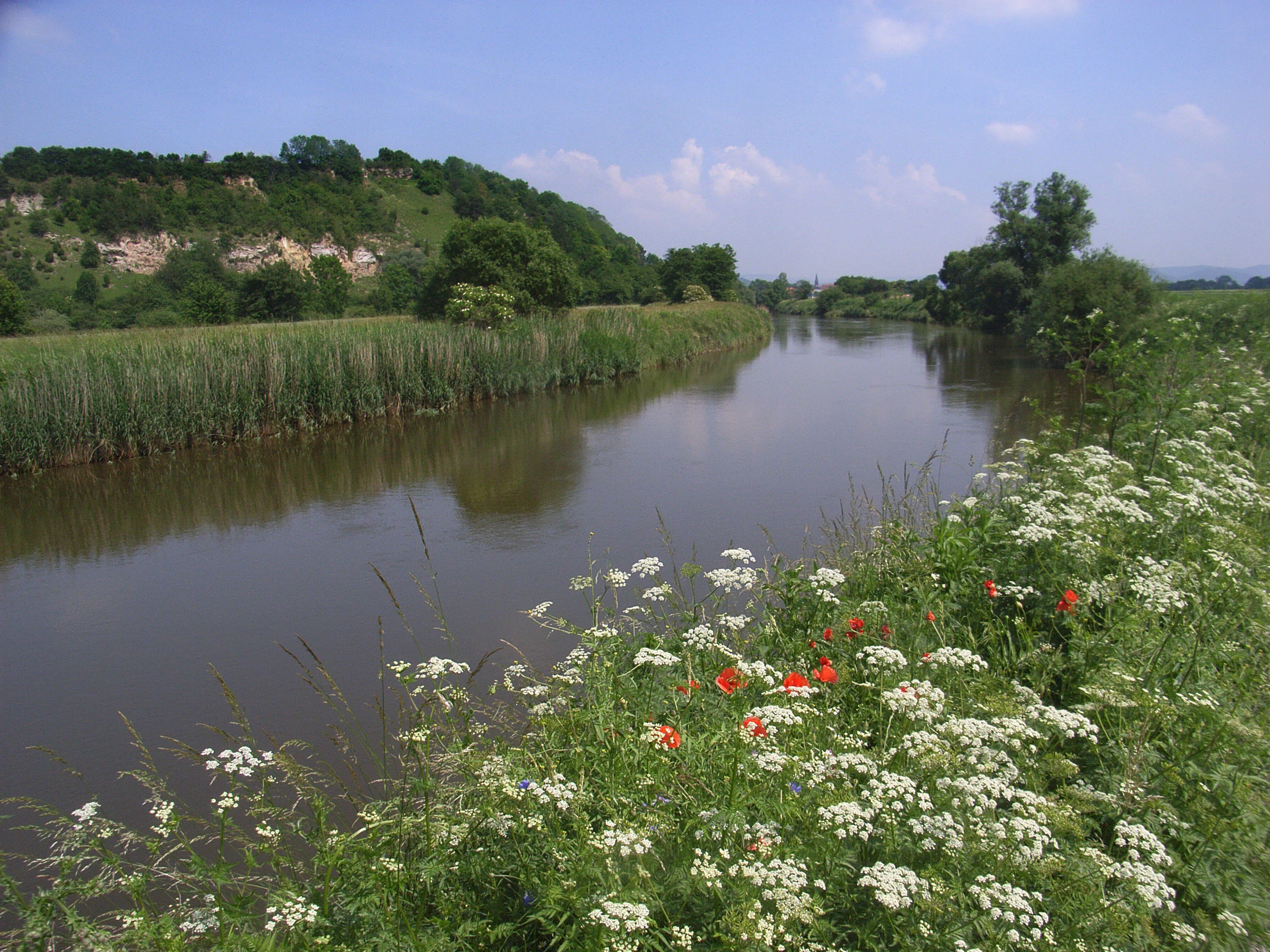
A wide river flows through a green valley, bordered by reeds and a wooded hill with exposed rock faces on the left, and white and red wildflowers in the grassy foreground on the right.
View of the Werra River flowing past the wooded slopes of the Jestädter Weinberg nature reserve, with wildflowers in the foreground.

Jestädter Weinberg wildlife and species highlights

The wildlife value of Jestädter Weinberg is concentrated in three groups: butterflies and burnet moths on the dry grasslands, dragonflies on the gravel-pit waters, and waterbirds and breeding birds along the Werra floodplain.

A baseline survey commissioned by the Obere Naturschutzbehörde at the Regierungspräsidium Kassel in 2003 recorded 36 butterfly and burnet moth species across the calcareous dry grasslands. While many are common, the survey noted several species classified as endangered on the Hessian Red List, including the comma skipper, the orange tip, the large fritillary, the Bath white and the esparcetten burnet moth.

A parallel 2003 survey on dragonflies documented 26 species in the aquatic and riparian habitats around the Weinberg and the neighbouring Werra-Altarm reserve. Alongside widespread species, the survey recorded the strongly endangered in Hesse Sympecma fusca, the red-eyed and small red-eyed damselflies, the scarce blue-tailed damselfly, the small mosaic dragonfly and the southern skimmer. The Werra floodplain, with its rebalancing of bird pressure between intensively developed upstream gravel lakes and the quieter Jestädter See, has regained importance as breeding, resting and foraging habitat for waterbirds.
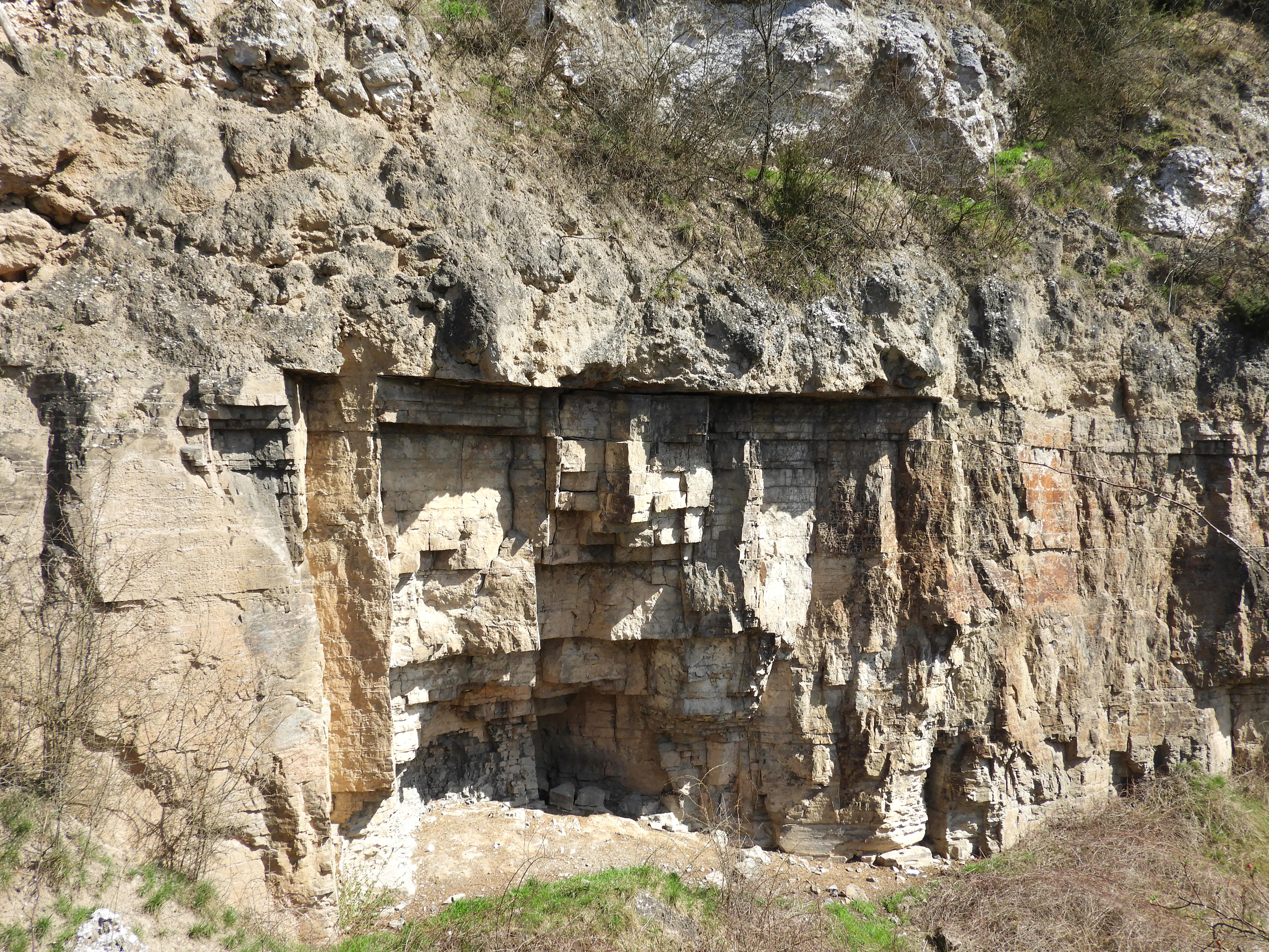
A steep rock face displaying horizontal geological strata in shades of grey, white, and brown, with sparse green vegetation at the top and bottom.
Exposed Zechstein limestone and gypsum layers at the western base of the Jestädter Weinberg.

Jestädter Weinberg conservation status and protection priorities

The conservation significance of Jestädter Weinberg rests on three overlapping layers. At the regional level, the area has been protected for nearly a century, first as a rock protection zone in 1924, then as a natural monument in 1937 and as a formal Hessian nature reserve in 1978.

At the European level, the combination of the Weinberg and Fürstenstein slopes with the Werra floodplain near Albungen was integrated into the Natura 2000 network under the EU Habitats Directive, with site number 4624-303 and WDPA code 555520065. The site is recognised for its statewide relevance for rare and threatened plant and animal species, its priority calcareous dry grassland habitats, and its function as a breeding, resting and foraging biotope for numerous bird species.

At the practical management level, the area's conservation has involved targeted habitat restoration: between 2000 and 2003, slopes were largely cleared of dense woody regrowth to secure the survival of the open dry grassland specialist flora, and extensive sheep grazing has been used to maintain the character of the lean grassland. Totholz, cavity trees and old pasture oaks are explicitly protected as part of the Fürstenstein woodland's structural image, and the river itself is affected by halophilic plant encroachment linked to potassium mining waste waters upstream in the Thuringian-Hessian border area.

Jestädter Weinberg cultural meaning and human context

The cultural dimension of Jestädter Weinberg is dominated by viticulture. The warm south-facing Zechstein slopes were historically among the most favourable vineyard locations in the Werra region, with wine believed to have been grown on the hill since the first millennium CE. In 1738, eight winzers are documented in Jestädt, working vineyards belonging to the local Herrenhaus. After declining yields in the late 18th century, viticulture was finally abandoned following the introduction of downy mildew from North America in the 1870s, though scattered grapevines have survived in the scrub.

A second layer of cultural imprint comes from later 19th- and 20th-century horticultural experimentation: mulberry trees planted in the 1930s to support silkworm breeding, old orchards and gardens whose lilac hedges and staghorn sumac bushes still mark the slope today, and relics like hyssop, rue, houseleek and blue iris that outlasted their original use as culinary, medicinal or ornamental plants. The Burg Fürstenstein crowning the neighbouring Fürstenstein ridge adds a medieval fortification element to the broader landscape context.
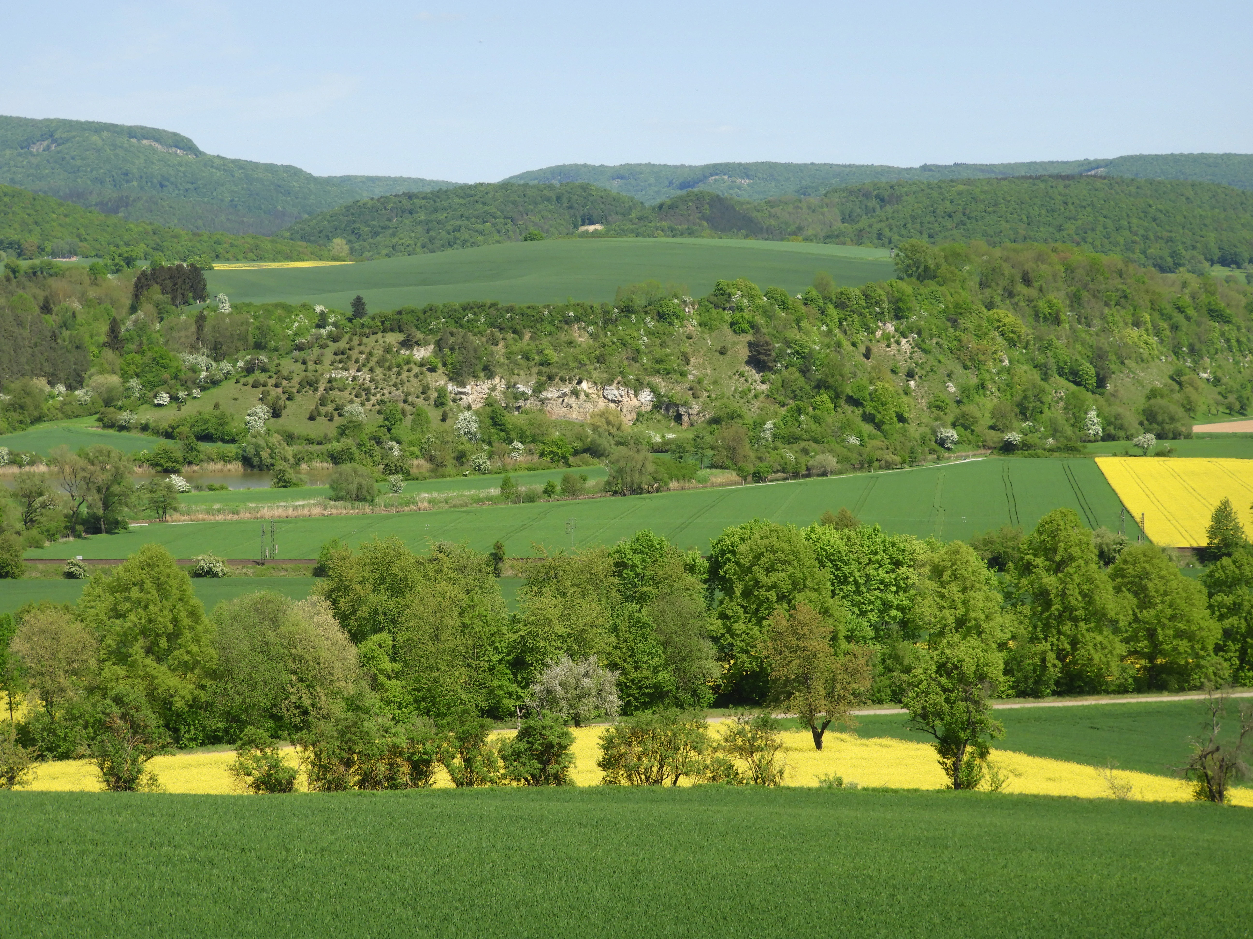
A wide landscape view showing rolling green hills, yellow rapeseed fields, scattered trees, and a rocky cliff face in the midground under a clear blue sky.
A view over the Werra river floodplain toward the southwestern slope of the Jestädter Weinberg, showing dolomite cliffs and surrounding agricultural fields.

Top sights and standout views in Jestädter Weinberg

A near-complete Zechstein geological profile, from Devonian slate through to reef-like Hauptdolomit cliffs, exposed within a single short stretch of the Werra valley.

A priority calcareous dry grassland habitat that shelters orchids such as twayblade, military orchid, fly orchid and bee orchid, together with juniper stands and a recorded assemblage of 36 butterfly and burnet moth species.

A floodplain mosaic along the Werra, where relict vineyard terraces, old pasture oaks on the Fürstenstein slope, willow thickets and an artificial gravel-pit lake jointly support a notable dragonfly fauna of at least 26 recorded species.
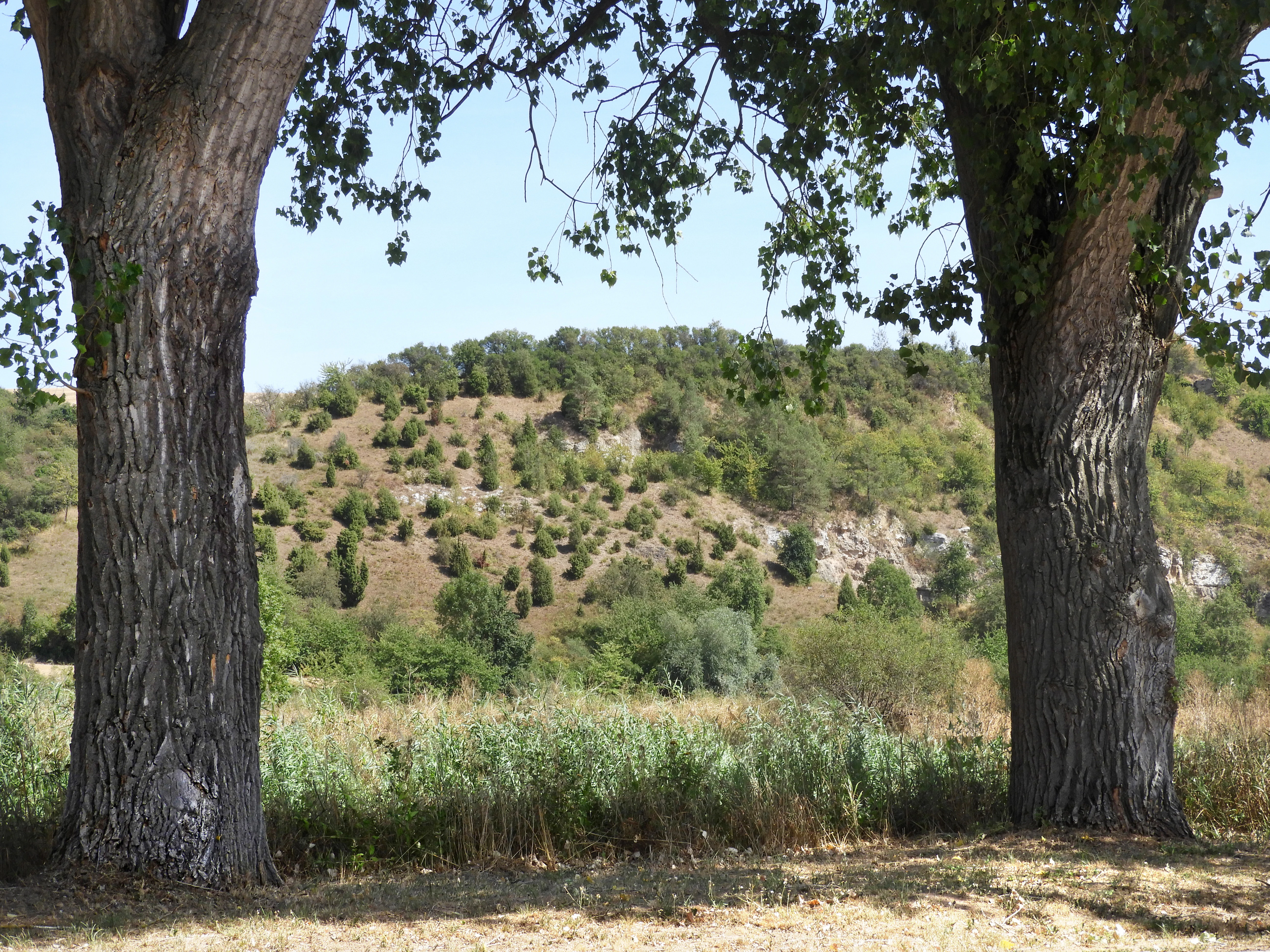
Two large tree trunks frame a view of a sunlit hill covered in dry grassland and scattered juniper bushes under a clear blue sky.
Dry grassland and juniper stands on a hill at Jestädter Weinberg, framed by two large tree trunks.

Best time to visit Jestädter Weinberg

The dry calcareous grasslands and orchid-rich slopes of the Jestädter Weinberg are at their most vivid from late spring through to mid-summer, when the warm microclimate brings out the orchid flora, the juniper stands and the butterfly assemblage documented in the 2003 baseline survey. Late spring is particularly rewarding for spring geophytes on the wooded Fürstenstein slope and for early flowering specialists on the dolomite rocks.

The Werra floodplain and gravel-pit waters have a different seasonal rhythm: late spring and summer are the main periods for dragonfly activity, while colder months can bring waterbird movement to the Jestädter See as the artificial lake rebalances pressure away from intensively developed upstream gravel lakes. In all seasons, the exposed rocks, cliffs and ridge panoramas are best appreciated in clear weather with good visibility across the Werra valley and towards the Gobert ridge.

Monthly climate preview

Long-term representative temperature and precipitation averages for Jestädter Weinberg

Jestädter Weinberg Climate Normals and Annual Weather by Month Profile

Historical climate data from 1991 to 2020 charts the measured monthly temperature progression and daily precipitation rates across Jestädter Weinberg. Exploring the full twelve-month records provides deeper comparative baseline normals for this protected area.
Annual mean8 °C
-1 °C18 °C
Jan-1°
Feb
Mar
Apr
May12°
Jun16°
Jul18°
Aug18°
Sep14°
Oct
Nov
Dec
Warmest month
July

18.3 °C

Coolest month
January

-1.1 °C

Wettest month
July

2.6 mm/day

Driest month
April

1.4 mm/day

Park location guide

Geography guide, regional context, and park location map for Jestädter Weinberg

Jestädter Weinberg park geography, regions, and map view in Germany

Understand where Jestädter Weinberg sits in Germany through a broader geographic reading of the surrounding landscape, nearby location context, and its mapped position within the national park landscape.

How Jestädter Weinberg fits into Germany

Germany is a federal republic in Western and Central Europe with a population of over 83 million across sixteen constituent states. It is Europe's largest economy by nominal GDP and a major global exporter and importer. The capital is Berlin, and the country borders Denmark, Poland, Czech Republic, Austria, Switzerland, France, Luxembourg, Belgium, and the Netherlands.

Wider geography shaping Jestädter Weinberg in Germany

Germany is located in Western and Central Europe, spanning 357,022 km². It borders Denmark to the north, Poland and the Czech Republic to the east, Austria and Switzerland to the south, and France, Luxembourg, Belgium, and the Netherlands to the west. The country has coastlines on the Baltic Sea and North Sea to the north, with the Alps located in the southern region.

Map view of Jestädter Weinberg

Use this park location map to pinpoint Jestädter Weinberg in Germany, understand its exact geographic position, and read its mapped placement within the surrounding landscape more clearly.

Pigeon | © OpenStreetMap contributors

Location context for Jestädter Weinberg

Werra-Meißner-Kreis

Explore photographic records of geological ridges, dry grasslands, and riverine environments.

Jestädter Weinberg Photos and Landscape Scenery: Visualizing Zechstein Cliffs and Protected Habitats

Examine high-resolution imagery showcasing the dramatic dolomite cliffs, steep south-facing slopes, and diverse microclimates defining the reserve. Visual documentation reveals the intricate mosaic of calcareous grassland, relict vineyard terraces, and floodplain habitats along the Werra valley.

A wide landscape view showing a large field of red poppies in the foreground, a line of green trees in the midground, and a forested hill with a castle structure on top in the background under an overcast sky.

A steep rocky cliff face with layered dolomite rock formations, vegetation growing on top and at the base, white rock rubble in the foreground, and a clear blue sky above.

A wide landscape photograph showing a field of white wildflowers in the foreground, leading to a river valley with green trees, fields, and rolling forested hills under a clear blue sky.

A wide river flows through a green valley, bordered by reeds and a wooded hill with exposed rock faces on the left, and white and red wildflowers in the grassy foreground on the right.

A steep rock face displaying horizontal geological strata in shades of grey, white, and brown, with sparse green vegetation at the top and bottom.

A massive, gnarled deciduous tree with a thick trunk and wide-spreading branches stands in the center of a forest, surrounded by thinner trees and a leaf-covered forest floor.

A wide landscape view showing rolling green hills, yellow rapeseed fields, scattered trees, and a rocky cliff face in the midground under a clear blue sky.

Two large tree trunks frame a view of a sunlit hill covered in dry grassland and scattered juniper bushes under a clear blue sky.

A flock of white sheep running up a dusty path on a green hillside with trees and a rocky outcrop under a clear blue sky.

A wooden trail marker post with a bicycle symbol and blue W letter stands in the foreground, with a tree-covered hillside showing rocky outcrops and a river with reeds visible below, under a clear blue sky

Park atlas

Compare surrounding Zechstein geology, river floodplains, and connected regional nature reserves

Parks Near Jestädter Weinberg: Explore Related Protected Landscapes and Regional Reserves

Discover related protected areas near Jestädter Weinberg to compare neighboring geological ridges and river valley habitats. Examining adjacent regional reserves provides broader context on northern Hesse conservation landscapes and local ecosystem patterns.
Nature reserveHessen
About 2.6 km away#1 closest

Northwest

Bilstein im Höllental: Protected Diabase Cliff and Ravine Forest in Hessen

Geological landscape and Natura 2000 protected area

Discover the geographic significance of Bilstein im Höllental, a nature reserve in the Werra-Meißner-Kreis that showcases a rare juxtaposition of warm rock refuges and cool, shaded ravine environments. The reserve protects significant cliff-dwelling plant communities and traces of medieval history upon its 284-meter diabase summit, providing a focused example of geological resistance shaping valley terrain.

Area
0.032 km²
Established
1960
IUCN
IV
Relief
Mountain
Nature reserveThuringia
About 4.8 km away#2 closest

Northeast

Stein, Rachelsberg, Gobert: A Protected Limestone Landscape in Western Thuringia

Mapping a historic nature reserve and beech forest complex

Stein, Rachelsberg, Gobert stands as a key protected area within Thuringia. This nature reserve offers deep insights into limestone ridge geography, historic border woodland continuity, and diverse habitats ranging from dry grasslands to tufa springs and orchid-rich beech forests.

Area
7.16 km²
Established
1999
IUCN
IV
Relief
Mountain
Nature reserveWerra-Meißner-Kreis
About 5.9 km away#3 closest

East

Mönchesrieth bei Grebendorf Nature Reserve in Werra-Meißner-Kreis, Germany

A restored wetland refuge in the Werra river floodplain.

Located in northern Hesse, Mönchesrieth bei Grebendorf is a protected nature reserve formed by the flooding of a former gravel extraction site. Its geography features a network of shallow bays and shoreline vegetation that provide essential nesting and foraging grounds for waterbirds within the busy Werra valley corridor. The site represents a successful transition from industrial terrain to a quiet, managed refuge for regional biodiversity.

Area
0.181 km²
Established
1999
IUCN
IV
Relief
Lowland
Nature reserveWerra-Meißner-Kreis
About 6.8 km away#4 closest

Northeast

Kalkklippen südlich des Iberges Nature Reserve and Muschelkalk Landscape Atlas

Protected beech forests and active landslide topography

This nature reserve in Werra-Meißner-Kreis reveals an active Muschelkalk ridge characterized by steep limestone cliffs and boulder-strewn talus slopes. Study the site's unique ecological composition, featuring noble hardwood-rich beech forests and native European yew populations that highlight the region's complex natural history and geological significance.

Area
0.473 km²
Established
1995
IUCN
IV
Nature reserveWerra-Meißner-Kreis
About 6.8 km away#5 closest

West

Kripp- und Hielöcher Nature Reserve: Karst Geography and Protected Land in Werra-Meißner-Kreis

Geology-focused nature reserve featuring gypsum sinkholes and dry grasslands.

Kripp- und Hielöcher provides a rare look at Zechstein gypsum karst in Hesse. The reserve is split into two distinct areas, the Kripplöcher and Hielöcher, showcasing natural rock monuments, active karst springs, and a historical cultural landscape maintained through centuries of traditional land use.

Area
0.17 km²
Relief
Upland
Climate
Temperate
Access
Moderate access
Nature reserveWerra-Meißner-Kreis
About 7.3 km away#6 closest

South

Blaue Kuppe Nature Reserve: Volcanic Basalt Landscapes in Werra-Meißner-Kreis, Germany

Protected geological monument and habitat zone

Blaue Kuppe is a notable basalt hill near Eschwege, preserved for its rare mineralogical record and exposed contact zones between volcanic lava and sedimentary sandstone. The site serves as a vital geological archive and protected nature reserve in the Werra-Meißner-Kreis, showcasing historical volcanic intrusions that shaped the local terrain.

Area
0.068 km²
Established
1939
IUCN
IV
Relief
Upland
Nature reserveHesse
About 7.5 km away#7 closest

West

Meißner Nature Reserve in Northern Hesse: Mapping the Hoher Meißner Basaltic Massif

A comprehensive look at forest wilderness, bogs, and volcanic geology

Covering roughly 930 hectares, the Meißner nature reserve in northern Hesse protects an ecologically distinct upland landscape. The area features a significant basalt plateau, ancient scree slopes, mountain meadows, and hanging spring bogs, offering a prime example of protected central German topography and forest wilderness.

Area
9.322 km²
Established
1989
IUCN
IV
Relief
Mountain
Nature reserveThuringia
About 8.3 km away#8 closest

North

Röhrsberg - Hasenwinkel - Mühlberg: Mapping the Protected Landscapes of Thuringia

Geological ridge systems and native forest habitat networks.

The Röhrsberg - Hasenwinkel - Mühlberg nature reserve represents a significant protected area in Thuringia, characterized by the juxtaposition of Muschelkalk limestone hills and Zechstein dolomite ridges. This site offers a concentrated view of regional terrain, shifting from closed beech forests to open juniper heaths. It serves as an essential geographic reference for understanding the ecological mosaic of the lower Werra hill country.

Area
4.51 km²
Established
1999
IUCN
IV
Relief
Upland

Common questions about visiting, size, designation, and location context for Jestädter Weinberg

Jestädter Weinberg FAQs for park facts, access, geography, and protected area context

Find quick answers about Jestädter Weinberg, including protected-area facts, park geography, trail and visitor context, and how the park fits into its surrounding country and regional landscape.
MoriAtlas Explorer

Continue Your Protected Areas Search Across the Global Atlas

Deepen your exploration by continuing the structured search for national parks and protected areas worldwide. Utilize the comprehensive filtering capabilities to compare different conservation landscapes and refine your understanding of global park geography. Discover more about the distribution and characteristics of protected natural areas.

Global natural geography