Mori Atlas logo
Wildlife reserveJim McClure–Jerry Peak Wilderness

Mapping the rugged terrain, forested ridgelines, and remote backcountry of central Idaho

Jim McClure–Jerry Peak Wilderness: An Analysis of Protected Mountain Geography in Idaho

The Jim McClure–Jerry Peak Wilderness represents a significant protected landscape within the Salmon-Challis region of central Idaho. This wilderness area preserves rugged mountain terrain, forested slopes, and high-elevation ridgelines that define the state's expansive backcountry. Through detailed geographic mapping, examine the intersection of federal land management and the natural topography of the Salmon River Mountains.

wilderness areacentral IdahoSalmon-Challis National ForestCuster Countymountain landscapeconiferous forest

Jim McClure–Jerry Peak Wilderness

Wildlife reserve

Park overview

Structured park overview, official facts, and landscape profile for Jim McClure, Jerry Peak Wilderness

Jim McClure, Jerry Peak Wilderness park facts, protected area profile, and essential visitor context

Review the core facts for Jim McClure, Jerry Peak Wilderness, including designation, size, terrain, visitor scale, habitats, and operating context in one park-focused overview.

About Jim McClure, Jerry Peak Wilderness

The Jim McClure–Jerry Peak Wilderness occupies a substantial portion of the central Idaho backcountry, situated in Custer County within the broader Salmon-Challis National Forest. Its terrain is shaped by the complex high-country topography characteristic of central Idaho, where mountain ranges, deep valleys, and extensive forests create a varied and largely undeveloped landscape. Management of the area is shared between the U.S. Forest Service and the Bureau of Land Management, reflecting the mixed federal ownership of surrounding lands.

Wilderness designation represents one of the highest levels of protection available for federal lands in the United States, and the Jim McClure–Jerry Peak Wilderness meets the criteria applied to such areas: outstanding ecological, geological, or scenic values, opportunities for solitude, and a primarily primitive and unconfined character of recreation. Within the broader Salmon-Challis region, the wilderness plays an important role in maintaining landscape-scale ecological connectivity by adjoining other designated wildernesses and bridging large tracts of protected wildland.

The area's character is shaped by its elevation and the limited road access typical of central Idaho wildernesses, which preserves the quality of solitude and natural processes across the landscape. Visitors who travel into the wilderness encounter forested ridges, open basins, and rugged peaks, including prominent summits such as Sheep Mountain, which has become associated with the visual identity of the area. Together, these qualities make the Jim McClure–Jerry Peak Wilderness a meaningful component of Idaho's modern system of protected backcountry.

Quick facts and research context for Jim McClure, Jerry Peak Wilderness

The Jim McClure–Jerry Peak Wilderness is located in Custer County, Idaho, with Challis serving as the nearest community of meaningful size. It falls within the broader Salmon-Challis National Forest system and is composed of National Forest lands as well as adjoining Bureau of Land Management parcels.

The wilderness protects a large expanse of central Idaho backcountry characterized by forested ridges, mountain terrain, and remote valleys typical of the Salmon River region. Its designation in 2015 brought it into the National Wilderness Preservation System, securing its wilderness character under federal management.

Protection and recognition

Terrestrial protected area established in 2015 with documented designation records.

Jim McClure–Jerry Peak Wilderness Protection Status and Designation History

Jim McClure–Jerry Peak Wilderness maintains a terrestrial protection scope established through official designation records from 2015. Documented protection status details provide clear baseline facts regarding the landscape without additional international recognition sources.

Protection details

Protection scope
Terrestrial
Designated year
2015
Transboundary protection
No
Park context

Deeper park guide and search-rich context for Jim McClure, Jerry Peak Wilderness

Jim McClure, Jerry Peak Wilderness history, landscape, wildlife, and travel context

Explore Jim McClure, Jerry Peak Wilderness through its history, landscape character, ecosystems, wildlife, conservation priorities, cultural context, and seasonal travel timing in a structured park guide built for atlas discovery and search intent.

Why Jim McClure, Jerry Peak Wilderness stands out

The wilderness is best known for its position within the remote Salmon-Challis landscape of central Idaho, where rugged mountains, forested ridges, and undeveloped valleys create a continuous backcountry setting. It sits in close proximity to other protected wildlands, including the Hemingway, Boulders Wilderness to the southwest and the Cecil D. Andrus, White Clouds Wilderness to the west, contributing to a larger landscape of preserved central Idaho terrain. Its identity is also strongly tied to its namesake, Jim McClure, a former United States Senator from Idaho who was a significant figure in the state's political and conservation history. The wilderness reflects both the natural character of the region and the legacy of Idaho leaders who worked to secure its protection through congressional action.
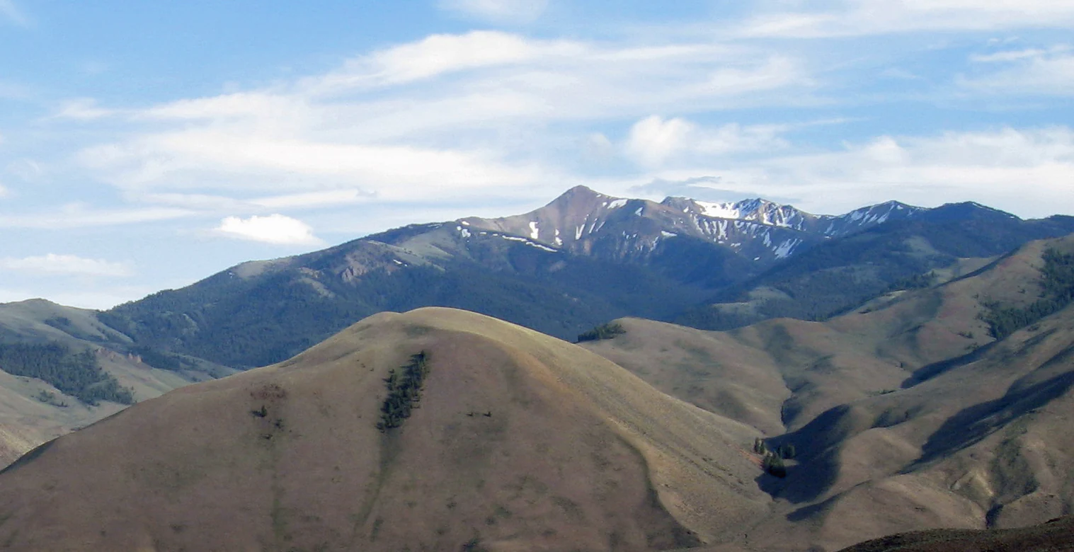
A wide view of the rugged, dry-grass mountain slopes of Sheep Mountain in the Jim McClure, Jerry Peak Wilderness, under a blue sky with light clouds.
Sheep Mountain within the Jim McClure, Jerry Peak Wilderness.

Jim McClure, Jerry Peak Wilderness history and protected-area timeline

The Jim McClure–Jerry Peak Wilderness was formally established on August 7, 2015, when it was added to the National Wilderness Preservation System. Its creation was authorized through the Sawtooth National Recreation Area and Jerry Peak Wilderness Additions Act, a piece of public legislation sponsored by Representative Mike Simpson of Idaho. The bill passed through Congress without objection, reflecting broad bipartisan support for expanding wilderness protection in the region, and was signed into law by President Barack Obama.

The wilderness is named in part after Jim McClure, a United States Senator from Idaho whose career left a lasting mark on the state's political and conservation history. By bearing his name alongside the Jerry Peak geographic designation, the legislation links the area's identity to both its landscape character and to long-running Idaho efforts to protect central Idaho's wild heritage.

The 2015 designation occurred as part of a wave of wilderness additions across the western United States during that period, building on decades of conservation work in the Salmon-Challis region. Its placement adjacent to the Hemingway–Boulders Wilderness and near the Cecil D. Andrus–White Clouds Wilderness reflects an evolving recognition of the importance of landscape-scale wilderness connectivity in central Idaho.

Jim McClure, Jerry Peak Wilderness landscape and geographic character

The landscape of the Jim McClure–Jerry Peak Wilderness is dominated by the kind of high, rugged terrain associated with the Salmon River Mountains and the broader central Idaho mountain country. Forested slopes rise into rocky ridgelines and open summits, with elevation shaping a gradient from valley bottoms to alpine zones. Sheep Mountain is among the notable peaks within the area, contributing to the visual profile of the wilderness.

Valleys and drainages cut through the mountainous terrain, fed by snowmelt and seasonal runoff typical of the region. These drainages support bands of dense forest along their lower reaches and transition upward into sparser, high-elevation environments. The overall topography creates a landscape of considerable relief, with long ridgelines and dramatic transitions between forested and exposed terrain.

The wilderness sits within a larger matrix of federal lands, adjoining the Hemingway–Boulders Wilderness to the southwest and lying east of the Cecil D. Andrus–White Clouds Wilderness. This broader geographic setting places the Jim McClure–Jerry Peak Wilderness in a region where mountain ranges, forested basins, and river systems flow together to form one of the more extensive tracts of undeveloped land in the lower 48 states.

Jim McClure, Jerry Peak Wilderness ecosystems, habitats, and plant life

Ecologically, the Jim McClure–Jerry Peak Wilderness lies within the forested heart of central Idaho, a region recognized for its large blocks of relatively intact vegetation and habitat. Coniferous forests dominate much of the area, covering the slopes and ridges that make up the majority of the wilderness. These forests reflect the climatic and elevational conditions of the region, supporting tree species and understory communities adapted to mountain environments in the interior American West.

Wildlife habitat across the wilderness benefits from the limited road access and the wilderness designation itself, which restricts motorized use and emphasizes the preservation of natural processes. The vertical relief of the terrain generates habitat diversity, with lower forested slopes, mid-elevation benches, and higher exposed ridges each supporting different plant and animal communities. Seasonal variation in snow cover and runoff shapes patterns of vegetation growth and habitat use throughout the year.

The wilderness's ecological value is amplified by its position relative to other protected areas. Its proximity to the Hemingway–Boulders Wilderness and the Cecil D. Andrus–White Clouds Wilderness contributes to ecological continuity across a much larger landscape, allowing wildlife populations and ecological processes to operate at scales that individual wildernesses alone cannot support.

Jim McClure, Jerry Peak Wilderness wildlife and species highlights

The Jim McClure–Jerry Peak Wilderness provides habitat for the wildlife typically associated with the forested mountains of central Idaho, where large tracts of undeveloped land support animal populations that depend on continuity of habitat. The terrain supports species adapted to mountain forests, high-country meadows, and rocky ridgelines, with elevation and seasonal snowpack shaping seasonal use of different parts of the wilderness.

The wilderness contributes to broader wildlife conservation in the region by adjoining the Hemingway–Boulders Wilderness and lying near the Cecil D. Andrus–White Clouds Wilderness, helping maintain connectivity across a network of protected lands. Such connectivity is important for wide-ranging species that require extensive habitat to thrive in central Idaho's mountain environments.

Jim McClure, Jerry Peak Wilderness conservation status and protection priorities

Conservation significance is central to the identity of the Jim McClure–Jerry Peak Wilderness. Formal wilderness designation places the area under the highest level of protection available for federal lands in the United States, restricting road building, motorized access, and other forms of development that could compromise its wilderness character. Management by the U.S. Forest Service and the Bureau of Land Management reflects the mixed ownership of the surrounding landscape and the coordinated approach required to protect such an area.

The wilderness's location within the Salmon-Challis National Forest places it in one of the most ecologically important forest landscapes in the contiguous United States, a region long recognized for its expansive blocks of unmodified habitat. By directly adjoining the Hemingway–Boulders Wilderness, the Jim McClure–Jerry Peak Wilderness strengthens landscape-scale conservation, ensuring that ecological processes and wildlife movements can occur across a much larger connected area.

The 2015 designation itself represented a conservation milestone, expanding the National Wilderness Preservation System at a time of renewed attention to protecting remaining wildlands in the American West. Its name honors Jim McClure, whose career was associated with Idaho's political and conservation legacy, linking the wilderness's identity to the longer story of protecting central Idaho's natural heritage.

Top sights and standout views in Jim McClure, Jerry Peak Wilderness

The Jim McClure–Jerry Peak Wilderness stands out as one of Idaho's more recent and substantial wilderness additions, protecting a large block of central Idaho backcountry within the Salmon-Challis landscape. Its scale and setting allow it to function as part of a larger wilderness network that includes the Hemingway–Boulders Wilderness and the Cecil D. Andrus–White Clouds Wilderness.

Among its defining qualities are the rugged forested ridges, prominent peaks such as Sheep Mountain, and the sense of remoteness that comes from its limited road access and high-elevation terrain. The wilderness offers a strong example of central Idaho's characteristic combination of mountains, forest, and solitude.

Best time to visit Jim McClure, Jerry Peak Wilderness

Summer is the primary season for visiting the Jim McClure–Jerry Peak Wilderness, when snow has generally melted from the lower and middle elevations and forest and ridge landscapes are most accessible. During this period, longer daylight hours and milder conditions support hiking, backpacking, and horseback travel into the wilderness.

Fall brings cooler temperatures, reduced crowds, and shifting color along forested ridges and drainages, offering a quieter experience of the landscape. Winter and spring bring deep snow across much of the wilderness, transforming the area into a snow-covered high-country environment where backcountry skiing and snowshoeing may be possible but where travel typically requires additional preparation and skill.

Monthly climate preview

Long-term temperature ranges and monthly precipitation records from representative coordinates

Jim McClure–Jerry Peak Wilderness Climate Normals and Annual Weather Patterns

Representative coordinates record sustained sub-zero winter temperatures alongside moderate summer maximums across the protected landscape. Examining complete monthly climate normals reveals detailed seasonal temperature shifts and precipitation totals.
Annual mean1 °C
-11 °C15 °C
Jan-11°
Feb-10°
Mar-6°
Apr-2°
May
Jun
Jul15°
Aug14°
Sep
Oct
Nov-5°
Dec-11°
Warmest month
July

15.2 °C

Coolest month
January

-10.7 °C

Wettest month
December

2.1 mm/day

Driest month
August

0.6 mm/day

Park location guide

Geography guide, regional context, and park location map for Jim McClure, Jerry Peak Wilderness

Jim McClure, Jerry Peak Wilderness park geography, regions, and map view in United States of America

Understand where Jim McClure, Jerry Peak Wilderness sits in United States of America through a broader geographic reading of the surrounding landscape, nearby location context, and its mapped position within the national park landscape.

How Jim McClure, Jerry Peak Wilderness fits into United States of America

The United States of America is a federal presidential republic and one of the world's largest countries by area and population. It consists of 50 states across a vast territory spanning multiple time zones, with its capital in Washington, D.C. and largest city in New York City. The nation has a diverse economy, influential political system, and significant cultural and military presence globally.

Wider geography shaping Jim McClure, Jerry Peak Wilderness in United States of America

The United States occupies a vast territory in North America, bordered by Canada to the north and Mexico to the south. The 48 contiguous states stretch from the Atlantic to the Pacific Ocean, while Alaska occupies the northwestern region and Hawaii is an archipelago in the Pacific. The country encompasses diverse terrain including the Rocky Mountains, Appalachian Mountains, Great Plains, and extensive river systems.

Map view of Jim McClure, Jerry Peak Wilderness

Use this park location map to pinpoint Jim McClure, Jerry Peak Wilderness in United States of America, understand its exact geographic position, and read its mapped placement within the surrounding landscape more clearly.

Pigeon | © OpenStreetMap contributors

Location context for Jim McClure, Jerry Peak Wilderness

Idaho
Recorded earthquake history

Review Recorded Seismic Activity near Jim McClure–Jerry Peak Wilderness

Examine the historical record of seismic events documented in the vicinity of this Idaho wilderness. This catalog offers a clear view of recorded magnitudes and epicentre distances to provide context on regional seismic activity.

Jim McClure–Jerry Peak Wilderness Earthquake History

Catalogued events

488 events

Strongest magnitude

Magnitude 6.9

Most recent event

Jun 8, 2025

This history includes earthquakes recorded inside the park or within 50 km of its borders

Visual exploration of high mountain terrain, forested ridges, and protected backcountry habitats.

Jim McClure–Jerry Peak Wilderness Photos, Landscapes, and Scenery

Visual documentation captures the rugged mountain ranges, coniferous forests, and high alpine ridgelines defining the protected terrain of Jim McClure–Jerry Peak Wilderness. Photographic collections provide a detailed look at remote backcountry environments, rocky summits, and undisturbed river drainages across central Idaho.

A wide view of the rugged, dry-grass mountain slopes of Sheep Mountain in the Jim McClure, Jerry Peak Wilderness, under a blue sky with light clouds.

Park atlas

Compare adjacent mountain wilderness reserves and connected central Idaho terrain.

Parks Near Jim McClure–Jerry Peak Wilderness and Surrounding Protected Areas

Browsing parks near Jim McClure–Jerry Peak Wilderness reveals a vast network of rugged mountain terrain and protected backcountry reserves across central Idaho. Comparing these adjacent wildlands provides deeper geographic context on regional elevation gradients and continuous conservation landscapes.
Soft watercolor illustration of a rolling mountain landscape with a forested foreground and faded, distant peaks.
Protected landscapeIdaho
Park boundaries overlap#1 closest

North

Salmon, Challis National Forest: Geography and Protected Land Map in Central Idaho

Extensive alpine ridges and wild river corridors

Spanning over 4.2 million acres, Salmon, Challis National Forest is a foundational protected landscape in Idaho. This area includes the highest peaks in the state, such as Borah Peak, and holds the majority of the Frank Church, River of No Return Wilderness. Utilize this atlas resource to examine the intricate mountain topography, expansive river systems, and the contiguous wild corridors that define this significant portion of the northern Rockies.

Area
17,142.2 km²
Established
1908
Relief
Mountain
Climate
Temperate
Watercolor painting of a calm lake surrounded by forested shores and distant mountains, depicted in soft pastel tones.
Protected landscapeIdaho
Park boundaries overlap#2 closest

Southwest

Sawtooth National Forest: Geographic Overview and Protected Mountain Boundaries

Central Idaho mountain systems and wilderness corridors

Spanning over two million acres, Sawtooth National Forest defines the heart of the Rocky Mountains in Idaho. This protected landscape contains a complex network of glacial basins, alpine lakes, and varied ecosystems ranging from arid sagebrush foothills to high-altitude peaks. Explore the internal boundaries, drainage systems, and structural geography of this significant wilderness area.

Area
8,540.52 km²
Established
1905
Visitors
1.2M annual
Relief
Mountain
Watercolor painting of a tranquil lake surrounded by green forests and soft mountain ridgelines against a white background.
Protected landscapeIdaho
Park boundaries overlap#3 closest

West

Sawtooth National Recreation Area: Mapping the Protected Landscape of Central Idaho

A vast mountain wilderness of granite peaks and glacier-carved lakes.

The Sawtooth National Recreation Area encompasses a quintessential northern Rocky Mountain terrain defined by the dramatic Sawtooth, White Cloud, and Boulder ranges. This protected landscape preserves over 700,000 acres of high-elevation wilderness, ranging from jagged granite arêtes to the broad, U-shaped Sawtooth Valley, serving as a critical hydrologic anchor for the rivers of the American West.

Area
2,957.7 km²
Established
1972
Relief
Mountain
Climate
Alpine
A horizontal watercolor illustration depicting a winding river flowing through a forested valley surrounded by soft, hazy mountain silhouettes.
Wildlife reserveIdaho
46 km away#4 closest

Northwest

Frank Church, River of No Return Wilderness: Idaho Protected Mountain and River Landscapes

Discover massive roadless geography and river-carved mountain terrain.

Spanning over 2.3 million acres in central Idaho, the Frank Church, River of No Return Wilderness represents one of the most significant intact roadless landscapes in the lower 48 states. This protected area features a complex mosaic of coniferous forests, high-altitude alpine ridges, and the steep, jagged canyons of the Salmon River, creating a unique geographic profile for regional exploration.

Area
9,578.21 km²
Established
1980
IUCN
Ib
Relief
Mountain
Protected landscapeIdaho
95 km away#5 closest

Northwest

Payette National Forest: Geographic Overview of Idaho's Rugged Mountain Wilderness

Protected granite landscapes and glacial basin geography

Encompassing a vast portion of central Idaho, Payette National Forest represents a significant protected wilderness corridor. The forest geography transitions from granite-based alpine peaks and deep river gorges to dense coniferous slopes, providing essential habitat and extensive trail connectivity throughout the Northern Rockies.

Area
9,419.55 km²
Established
1944
Relief
Mountain
Access
Access unknown
Nature reserveBeaverhead County
183 km away#6 closest

East

Red Rock Lakes Wilderness: Nature Reserve and Wetland Geography in Beaverhead County

High elevation marshes and protected water basins.

Red Rock Lakes Wilderness preserves an extensive high-elevation wetland complex in Beaverhead County, Montana. This nature reserve, characterized by shallow lake basins and forested mountain ridges, serves as a vital ecological corridor in the Northern Rockies. Its protected landscape offers a study in water-driven geography, where remote marshes and reflective lakes define the terrain's character.

Area
130.9 km²
Established
1976
IUCN
Ib
Relief
Upland
A watercolor painting showing a wide view of a desert canyon landscape with layered plateaus and earthy tones.
Wildlife reserveIdaho
About 204 km away#7 closest

Southwest

Little Jacks Creek Wilderness: Mapping Idaho Canyon Country and Protected Landscapes

Basalt plateau and stream-cut gorge geography

Little Jacks Creek Wilderness protects a significant high-desert landscape in Idaho characterized by deep canyons and sagebrush-covered plateaus. As part of the Owyhee Canyonlands, this wildlife reserve highlights the geologic interplay of dark basalt and red rhyolite cliffs, providing a stable, undisturbed terrain for geographic and ecological study.

Area
206.1 km²
Established
2009
IUCN
Ib
Relief
Upland
A watercolor painting of a wide, rolling landscape with green hills, a winding path or river, and soft mountains in the background against a white background.
Protected landscapeUnited States of America
205 km away#8 closest

Northwest

Hells Canyon National Recreation Area: Geologic Boundaries and Snake River Corridor Atlas

Deep canyon terrain and archaeological heritage in the American Northwest

This protected landscape encompasses the profound depth of the Snake River gorge, featuring rugged basalt cliffs and diverse forested uplands. The area serves as a significant intersection of natural history and ancient cultural presence, providing a detailed look at the topographic complexity defining the Oregon and Idaho boundary region.

Area
2,641 km²
Established
1975
Relief
Mountain
Climate
Temperate

Common questions about visiting, size, designation, and location context for Jim McClure, Jerry Peak Wilderness

Jim McClure, Jerry Peak Wilderness FAQs for park facts, access, geography, and protected area context

Find quick answers about Jim McClure, Jerry Peak Wilderness, including protected-area facts, park geography, trail and visitor context, and how the park fits into its surrounding country and regional landscape.
MoriAtlas Explorer

Continue Your Protected Areas Search Across the Global Atlas

Deepen your exploration by continuing the structured search for national parks and protected areas worldwide. Utilize the comprehensive filtering capabilities to compare different conservation landscapes and refine your understanding of global park geography. Discover more about the distribution and characteristics of protected natural areas.

Global natural geography