
Mori Atlas logo
Nature reserveJohannisegge-Schornstein

Analyzing the protected beech woodland, ridge terrain, and watershed geography of this Westphalian nature reserve.

Johannisegge-Schornstein Nature Reserve: Mapped Protected Landscapes and Ridge Geography

Johannisegge-Schornstein comprises a protected nature reserve in Borgholzhausen, North Rhine-Westphalia, where steep south-facing slopes support historically significant beech woodland. The area marks a distinct portion of the Teutoburg Forest ridge, situated near the Weser-Ems watershed divide. This site combines forest conservation with topographic vantage points like the 291-meter Johannisegge ridge, providing a layered geological character that integrates both natural habitats and regional cultural landmarks.

beech forestcoppice woodlandwarm-exposure slopesNiederwaldIUCN Category IVnature reserve
A graphic illustration showing a river winding through a valley beneath steep cliffs and a tall waterfall, surrounded by coniferous forest.

Johannisegge-Schornstein

Nature reserve

Park overview

Structured park overview, official facts, and landscape profile for Johannisegge, Schornstein Nature Reserve

Johannisegge, Schornstein Nature Reserve park facts, protected area profile, and essential visitor context

Review the core facts for Johannisegge, Schornstein Nature Reserve, including designation, size, terrain, visitor scale, habitats, and operating context in one park-focused overview.

About Johannisegge, Schornstein Nature Reserve

Johannisegge–Schornstein lies on the southern edge of the Teutoburg Forest region, within the town limits of Borgholzhausen and just below the state line with Lower Saxony. Designated as a nature reserve in 2001, it encompasses about 225 hectares of wooded slopes and ridges that together form one of the more characteristic protected forest landscapes in the Gütersloh district. The reserve's identifier, GT-035, places it within a regional network of Naturschutzgebiete managed to conserve habitats and species of particular local and statewide significance.

The defining natural feature of the reserve is its beech forest. Unlike the cooler, often more mesic woodlands that dominate the uplands of North Rhine-Westphalia, the Johannisegge–Schornstein beech stands grew on steep slopes facing south and southwest, where sunlight, warmth, and well-drained soils create conditions close to those found along the warm margins of Germany's central uplands. Many of these trees descended from a long tradition of Niederwald, or coppice woodland, in which branches were periodically cut for use as fuel wood or small timber. The combination of warm exposure and centuries of human management produced a distinctive forest composition that modern conservation policy aims to keep intact.

Equally important is the reserve's setting on the watershed between two of northern Germany's great river systems. The Weser-Ems watershed divide passes close to the protected area, meaning that rain falling on one side eventually reaches the Weser, while rain on the other reaches the Ems. That geographic position gives the slopes of Johannisegge and the nearby Schornstein area a particular ecological importance: they sit on the climatic and hydrological transition between lowland Westphalia and the lower Saxon hill country.

The reserve is more than a forest block. On the Johannisegge ridge, the Luisenturm observation tower draws hikers, sightseers, and school groups throughout the year, while the Hermannsweg, a long-distance walking trail running 156 kilometers from Rheine to the Velmerstot, passes directly through. On the southern flank, the Bönkersche Steinbruch quarry is used by the town of Borgholzhausen as an open-air venue, hosting theater performances and community events against a backdrop of forest and rock. Even structures that are not formally part of the protected area, like a fenced, decommissioned NATO communications site formerly used by the Royal Netherlands Air Force and the United States military, have acquired a conservation role: the site now shelters bats and supports two wind turbines that can supply a meaningful share of Borgholzhausen's household electricity.

Quick facts and research context for Johannisegge, Schornstein Nature Reserve

Johannisegge–Schornstein is a German nature reserve of approximately 225 hectares, classified under IUCN Category IV as a Habitat/Species Management Area. It carries the official identifier GT-035 within North Rhine-Westphalia's protected-area register and is administered by the lower landscape authority (Untere Landschaftsbehörde) of the Gütersloh district.

The reserve occupies hilly terrain near the Lower Saxony border, close to the Weser-Ems watershed. Its core natural value lies in beech forests that developed historically through coppice use on steep, warm-exposure slopes, an ecological niche that the 2001 designation sought to preserve.

Protection and recognition

Explore documented terrestrial conservation parameters and international recognition data

Johannisegge-Schornstein Protection Status and Designated Area Record

Johannisegge-Schornstein maintains a documented terrestrial protection status within official conservation databases. Verified records assemble management scope and designation parameters for reliable geographical analysis.

Protection details

Protection scope
Terrestrial
Transboundary protection
No
WDPA ID
318613
Park context

Deeper park guide and search-rich context for Johannisegge, Schornstein Nature Reserve

Johannisegge, Schornstein Nature Reserve history, landscape, wildlife, and travel context

Explore Johannisegge, Schornstein Nature Reserve through its history, landscape character, ecosystems, wildlife, conservation priorities, cultural context, and seasonal travel timing in a structured park guide built for atlas discovery and search intent.

Why Johannisegge, Schornstein Nature Reserve stands out

The reserve is best known for its beech woodland on steep south- and southwest-facing slopes, a habitat shaped by centuries of coppice, or Niederwald, management. This combination of exposure, soil, and historical land use gives the site a distinctive forest character that stands out against the surrounding Westphalian landscape. Equally recognizable is the Luisenturm, the fourth version of a lookout tower first built on the Johannisegge ridge in 1893 in memory of Luise of Prussia. The current 21-meter tower, inaugurated in 1991, sits directly on the 156-kilometer Hermannsweg trail and offers views across Borgholzhausen, toward the Porta Westfalica in the northeast, and deep into the Münsterland in the southwest.
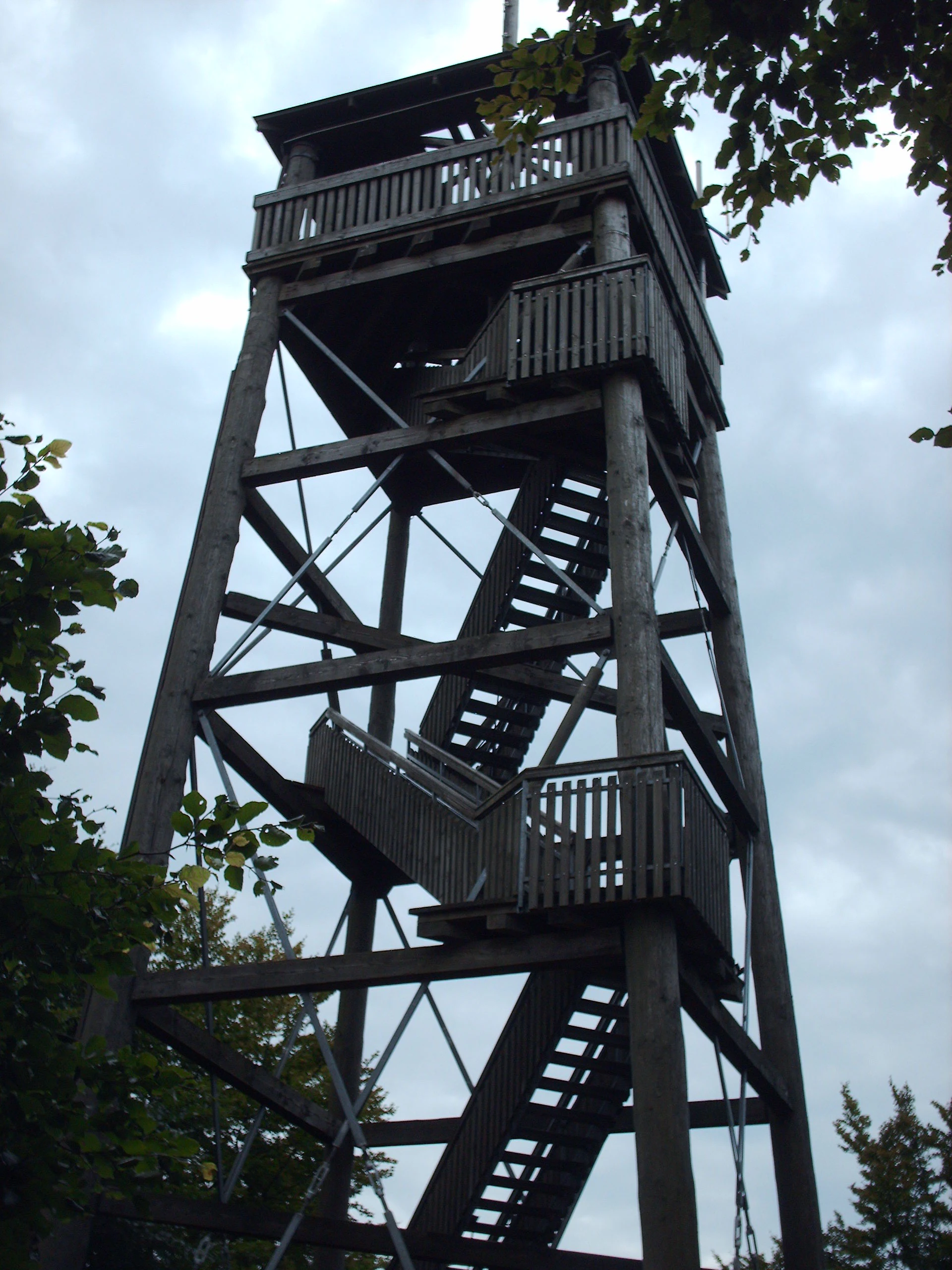
A tall, wooden lattice-style observation tower with an external staircase rising against a cloudy sky.
The Luisenturm observation tower, a prominent landmark within the Johannisegge-Schornstein reserve.

Johannisegge, Schornstein Nature Reserve history and protected-area timeline

The forest that today forms the Johannisegge–Schornstein reserve has deep cultural roots. Its beech stands descended from a long history of Niederwald, or coppice management, in which local communities periodically harvested regrowth from the same trees for firewood, charcoal, and small-scale timber. Over generations this practice shaped both the structure and the species composition of the woodland, producing the warm-slope beech forests that conservationists later sought to protect.

The lookout tradition on the Johannisegge ridge dates back to 1893, when a wooden observation tower was erected on the hilltop in memory of Luise of Prussia. The structure has since been replaced several times. The current Luisenturm, the fourth on the site, was inaugurated in 1991 and rises 21 meters above the summit, preserving the long-standing function of the hill as a panoramic viewpoint over Borgholzhausen and the surrounding lowlands and ridges.

Modern protection history begins with the reserve's designation in 2001, when it was officially registered as a Naturschutzgebiet under the identifier GT-035 and placed under the administration of the lower landscape authority of the Gütersloh district. The purpose was to preserve the beech forests on steep south- and southwest-facing slopes, a habitat pattern considered distinctive enough to warrant dedicated conservation status within the North Rhine-Westphalian protected-area system.

In the second half of the twentieth century, a NATO communications station operated between 1958 and 1983 inside the broader area, used by the Royal Netherlands Air Force and, in part, by the United States Armed Forces. After decommissioning, the fenced site was left undisturbed long enough to become a refuge for bats, illustrating how former military infrastructure can acquire a new ecological role once human activity ceases.

Johannisegge, Schornstein Nature Reserve landscape and geographic character

Johannisegge–Schornstein sits on a section of the Teutoburg Forest and adjacent ridges where the terrain tilts noticeably downhill to the south and southwest. The protected area captures the steeper, more exposed faces of these slopes, where beech trees cling to well-drained soils that warm quickly under direct sun. The resulting forest has a noticeably drier and more open feel than the cooler, denser woodlands found on north-facing slopes further up the ridge.

The most prominent elevation within the reserve is the Johannisegge, rising to about 291 meters above sea level. Its summit is crowned by the Luisenturm, whose position makes it one of the clearest vantage points in the area. From the tower, the landscape opens to broad views over Borgholzhausen and the gently undulating countryside of central Westphalia. On clear days the eye can travel northeast to the Porta Westfalica, the dramatic gorge where the Weser River cuts through the Wiehen Hills, and southwest across the open agricultural plains of the Münsterland.

Just beyond the southern boundary lies the Bönkersche Steinbruch, a former quarry whose exposed rock walls give the area a layered geological character. The quarry has been softened by surrounding woodland and integrated into the town of Borgholzhausen's cultural life as an event venue. Together, the steep beech slopes, the ridgeline of the Johannisegge, the rocky southern quarry edge, and the bordering plateau farmland shape a landscape that mixes forest, rock, agricultural ground, and small built features within a single compact reserve.

Johannisegge, Schornstein Nature Reserve ecosystems, habitats, and plant life

The reserve's ecological identity is built around warm-exposure beech forest, a narrow but ecologically valuable habitat type in this part of Westphalia. The beech stands originated from a long tradition of Niederwald, or coppice management, which favored repeated regrowth from cut stumps and gradually shaped the structure of the forest. Today, the conservation goal is to maintain the character of these forests while allowing them to evolve under their own dynamics, in line with the site's IUCN Category IV status as a Habitat/Species Management Area.

Because the reserve hugs the Weser-Ems watershed divide, soils on the warmer slopes are well-drained and relatively dry, while slopes on the opposite side retain more moisture. This contrast supports different microhabitats within a small area and gives the reserve a compact but layered ecological character. Habitats range from the open beech canopy on south-facing slopes to denser, shadier stands on cooler exposures, and from the rock faces of the Bönkersche Steinbruch to the small clearings associated with the lookout tower and the Hermannsweg trail.

The IUCN management category also signals that the area is treated not just as untouched nature but as a habitat actively managed to maintain certain species and conditions. That management includes protecting the beech forest structure and preserving features such as old trees, deadwood, and the rocky quarry walls, all of which contribute to habitat diversity within the reserve's 225 hectares.

Johannisegge, Schornstein Nature Reserve wildlife and species highlights

Wildlife information in the source material is limited, but the reserve is clearly recognized as habitat for bats, which use the decommissioned NATO station that lies within the broader area as a refuge. The fenced former military site, shut down in 1983, has aged into a quiet, undisturbed structure that offers the dark interior conditions bats favor, and it is now considered one of the more interesting secondary habitat features of the area even though the station itself is not formally part of the Naturschutzgebiet.

Beyond bats, the warm-exposure beech slopes, the cooler shaded slopes, the rock walls of the Bönkersche Steinbruch, and the mixed forest edges around the reserve provide varied niches for forest birds, small mammals, and invertebrates typical of the southern Teutoburg Forest region. However, the available source does not provide specific species lists, so detailed wildlife content beyond the bat refuge reference cannot be reliably presented.

Johannisegge, Schornstein Nature Reserve conservation status and protection priorities

Johannisegge–Schornstein is classified under IUCN Category IV as a Habitat/Species Management Area, a designation that reflects active management rather than purely passive protection. Its official identifier, GT-035, places it within North Rhine-Westphalia's network of state-registered nature reserves (Naturschutzgebiete), and it is administered by the lower landscape authority of the Gütersloh district under state nature conservation law.

The central conservation concern is the preservation of beech woodland that developed on unusually steep south- and southwest-facing slopes, originating from historical Niederwald, or coppice, use. Such warm-exposure beech forests are relatively uncommon in the Westphalian landscape, and the reserve was designated in 2001 specifically to maintain their forest structure, species composition, and associated microhabitats.

A second conservation thread is the growing ecological role of man-made structures within and beside the reserve. The decommissioned NATO station, abandoned in 1983, has become a bat refuge, while two wind turbines on the same site now contribute renewable energy to Borgholzhausen households (reportedly up to around 14 percent of the town's electricity supply). This combination of protected forest, repurposed military infrastructure for wildlife, and renewable energy generation illustrates how a relatively small protected area can host multiple, overlapping conservation and sustainability functions.

Johannisegge, Schornstein Nature Reserve cultural meaning and human context

The reserve carries clear cultural layering beyond its ecological role. The Luisenturm lookout tower, first built in 1893 in memory of Luise of Prussia, gives the Johannisegge summit a long tradition as a public viewpoint. The structure has been rebuilt several times, and the current 21-meter tower, inaugurated in 1991, continues that tradition while also serving as a waypoint on the Hermannsweg, a long-distance walking route that runs 156 kilometers from Rheine to the Velmerstot.

The Bönkersche Steinbruch, on the southern edge of the broader area, adds a second cultural element. Originally a working quarry, it has been taken on by the town of Borgholzhausen as a venue for community events, including theater performances, that draw residents and visitors into the landscape setting of the reserve.

The presence of the former NATO communications station, operated between 1958 and 1983 by the Royal Netherlands Air Force and partly by the United States military, is a more recent cultural imprint. Although the fenced compound itself is not formally part of the Naturschutzgebiet, its Cold War history, its transformation into a bat refuge, and the addition of two wind turbines on the same site make it an unusual background feature in the cultural narrative of the reserve.

Top sights and standout views in Johannisegge, Schornstein Nature Reserve

Among Johannisegge–Schornstein's most distinctive features are the south- and southwest-facing beech slopes with their coppice-origin forest structure, the panoramic Luisenturm on the 291-meter Johannisegge ridge, and the Bönkersche Steinbruch quarry that doubles as a community event space. The reserve also straddles the Weser-Ems watershed divide, giving it a compact but ecologically layered geography.

A more unusual highlight is the former NATO station within the broader area: decommissioned, bat-friendly, and now topped by wind turbines, it links the reserve's conservation story with both its Cold War past and local renewable energy production. The Hermannsweg, running through the area on its 156-kilometer route from Rheine to the Velmerstot, ties the site into a wider hiking network across the Teutoburg Forest and Lippe uplands.

Best time to visit Johannisegge, Schornstein Nature Reserve

The reserve is accessible year-round, with each season offering a different character. Spring brings fresh leaf growth to the beech canopy and cooler temperatures that suit longer walks along the Hermannsweg. Summer highlights the dry, warm character of the south-facing beech slopes and offers the clearest panoramic views from the Luisenturm toward the Porta Westfalica and the Münsterland.

Autumn is particularly notable because beech forests on warm slopes often display more pronounced color contrasts than cooler forests, and the broad views from the tower remain crisp under autumn light. Winter visits are quieter, with bare canopies revealing the slope structure and the long views from the Luisenturm becoming especially striking in clear conditions, though visitors should expect shorter daylight hours and the usual need for appropriate clothing on exposed ridges.


Monthly climate preview

Long-term representative monthly temperature and precipitation patterns

Johannisegge-Schornstein Climate Normals and Annual Temperature Rhythm

Representative coordinate measurements reveal annual temperature swings and consistent precipitation rates across twelve distinct intervals. Detailed monthly records supply complete historical climate normals for comprehensive study.
Annual mean9 °C
1 °C18 °C
Jan
Feb
Mar
Apr
May13°
Jun16°
Jul18°
Aug18°
Sep14°
Oct10°
Nov
Dec
Warmest month
July

18.4 °C

Coolest month
January

0.9 °C

Wettest month
December

2.6 mm/day

Driest month
April

1.6 mm/day

Park location guide

Geography guide, regional context, and park location map for Johannisegge, Schornstein Nature Reserve

Johannisegge, Schornstein Nature Reserve park geography, regions, and map view in Germany

Understand where Johannisegge, Schornstein Nature Reserve sits in Germany through a broader geographic reading of the surrounding landscape, nearby location context, and its mapped position within the national park landscape.

How Johannisegge, Schornstein Nature Reserve fits into Germany

Germany is a federal republic in Western and Central Europe with a population of over 83 million across sixteen constituent states. It is Europe's largest economy by nominal GDP and a major global exporter and importer. The capital is Berlin, and the country borders Denmark, Poland, Czech Republic, Austria, Switzerland, France, Luxembourg, Belgium, and the Netherlands.

Wider geography shaping Johannisegge, Schornstein Nature Reserve in Germany

Germany is located in Western and Central Europe, spanning 357,022 km². It borders Denmark to the north, Poland and the Czech Republic to the east, Austria and Switzerland to the south, and France, Luxembourg, Belgium, and the Netherlands to the west. The country has coastlines on the Baltic Sea and North Sea to the north, with the Alps located in the southern region.

Map view of Johannisegge, Schornstein Nature Reserve

Use this park location map to pinpoint Johannisegge, Schornstein Nature Reserve in Germany, understand its exact geographic position, and read its mapped placement within the surrounding landscape more clearly.

Pigeon | © OpenStreetMap contributors

Location context for Johannisegge, Schornstein Nature Reserve

North Rhine-Westphalia

Visualizing the beech woodlands, steep ridges, and terrain of Westphalia

Johannisegge-Schornstein Landscape Photos and Protected Area Scenery

Visual records capture the distinctive beech forest stands, exposed slopes, and elevated ridgeline environments defining Johannisegge-Schornstein. Detailed photography provides clear insight into the protected landscape character, geological features, and natural habitats spanning the reserve.

A tall, wooden lattice-style observation tower with an external staircase rising against a cloudy sky.

A wide, eye-level outdoor shot showing a green agricultural field and an asphalt road in the foreground, with distant, low rolling hills covered in forest under a clear blue sky. Small text labels identifying Johannisegge and Schornstein are visible on the horizon.

Park atlas

Compare surrounding Westphalian nature reserves and connected forest habitats.

Parks Near Johannisegge-Schornstein: Protected Areas and Ridgeline Landscapes

Trace regional protected areas adjacent to Johannisegge-Schornstein to evaluate similar ridge topography and forest ecosystems. Expand geographic comparison across neighboring terrain and connected conservation zones.
Watercolor painting of soft, rolling green hills and a gentle mountain silhouette against a pastel sunrise sky.
Nature reserveNordrhein-Westfalen
About 7.5 km away#1 closest

Southeast

Knüll-Storkenberg Nature Reserve: Mapping the Protected Terrain of the Teutoburg Forest

A diverse protected landscape of forest, spring-fed valleys, and grassland

Knüll-Storkenberg stands as a protected nature reserve in Nordrhein-Westfalen, encompassing a range of habitats from beech forests to sedge-filled valley meadows. This area integrates an abandoned limestone quarry into its managed landscape, creating a varied microclimate that supports distinct plant and animal communities. Its geography is anchored by the Knüll and Storkenberg hills, connected by the Wiesental valley.

Area
0.789 km²
Established
2001
IUCN
IV
Watercolor painting of a green and pink moor landscape with a distant tree line.
Nature reserveNordrhein-Westfalen
About 18 km away#2 closest

South

Hühnermoor Nature Reserve: Geographic Analysis of a Protected Peatland in Nordrhein-Westfalen

A preserved raised-bog landscape and historic botanical refuge

Hühnermoor represents a rare, compact peatland ecosystem situated between ancient sand dunes in the Münsterland region. This nature reserve functions as a critical protected landscape, offering deep insights into regional vegetation history through its stratified peat layers while supporting threatened specialist wetland species.

Area
0.085 km²
Established
1938
IUCN
IV
Relief
Lowland
A wide watercolor illustration showing a green landscape with a winding white path or stream, pink blossoming trees, and distant purple mountains under a pale sky.
Nature reserveNorth Rhine-Westphalia
About 18 km away#3 closest

Northeast

Kilverbachtal Nature Reserve: Protected Valley Geography in North Rhine-Westphalia

A refined look at lowland stream morphology and regional riparian habitats.

Kilverbachtal preserves a rare example of a narrow, box-shaped stream valley known as a Siek. This protected landscape features a mosaic of wet meadows, alder-lined riparian zones, and forested slopes that cut through the agricultural terrain of North Rhine-Westphalia. The area acts as a vital refugium for specialized flora and fauna, providing deep insight into the regional natural heritage and geological character of northwestern Germany.

Area
1.07 km²
Relief
Lowland
Climate
Temperate
Access
Access unknown
Nature reserveLandkreis Osnabrück
About 22 km away#4 closest

West

Sudendorfer Vennepohl Nature Reserve: Geography and Protected Wetland Atlas

A significant peatland site in Landkreis Osnabrück, Germany.

Explore the geographic identity of Sudendorfer Vennepohl, a protected lowland mire situated in the Osnabrück plain. This site is defined by its sandy substrate, pine forest surroundings, and rare bog flora that thrives in nutrient-poor, acidic conditions. Understanding its origins as an ancient river oxbow provides essential context for the ongoing conservation of this unique wetland relict.

Area
0.204 km²
Established
1951
IUCN
IV
A watercolor painting showing a soft, peaceful landscape with bare trees in the foreground, green trees in the midground, and distant hills under a pale sky.
Nature reserveNorth Rhine-Westphalia
About 24 km away#5 closest

Southeast

Kampeters Kolk Nature Reserve: Geographic Overview and Protected Wetland Boundaries

Senne region heath pond and wetland mosaic in North Rhine-Westphalia

Kampeters Kolk preserves a significant fragment of the historic Senne heath landscape in North Rhine-Westphalia. The reserve centers on a small, artificial pond created by peat extraction, now surrounded by a rich sequence of sedges, reed stands, and willow-alder shrub thickets that provide critical habitats for local amphibian populations.

Area
0.02 km²
Established
1993
IUCN
IV
Watercolor painting of a rolling forested landscape with hills in the background and a gentle valley floor in the foreground, rendered in soft green and earth tones.
Nature reserveNorth Rhine-Westphalia
About 25 km away#6 closest

Northeast

Limberg und Offelter Berg: Exploring Protected Forest Landscapes in North Rhine-Westphalia

Nature reserve geography and Wiehen Hills woodland terrain

Limberg und Offelter Berg is a foundational nature reserve in eastern Westphalia, known for its well-preserved beech forest mosaic and the protected headwaters of the Landwehrbach. Positioned on the eastern ridge of the Wiehen Hills, the area features a varied terrain of forested slopes and small valleys. It remains a critical study area for native woodland communities, reflecting eight decades of continuous landscape protection in the Minden-Lübbecke district.

Area
1.861 km²
Established
1935
Relief
Upland
Scope
Terrestrial
Nature reserveNordrhein-Westfalen
About 27 km away#7 closest

East

Windweheniederung Nature Reserve: Geographic Atlas of an East Westphalian Floodplain

Riparian ecosystems and protected valley land mapping

Windweheniederung represents a specialized nature reserve in Nordrhein-Westfalen that centers on the natural morphology of the Windwehe stream. This protected area provides a critical refuge for wetland-dependent species through its alder-ash woodland and reed-fringed pools. Explore the structural geography of this lowland catchment and understand its role in maintaining functional floodplains amidst a heavily developed regional environment.

Area
0.297 km²
Established
1991
IUCN
IV
Nature reserveBavaria
About 27 km away#8 closest

Northwest

Steinernes Meer Nature Reserve: Protected Glacial Boulder Landscapes and Geological Terrain

Geological heritage and forest terrain in the Osnabrück district

Steinernes Meer Nature Reserve covers a dense cluster of large glacial erratic boulders known as findlings. These massive stones, left by retreating ice sheets, create a striking, stony forest floor that defines the reserve as a significant geological landmark within the broader regional landscape.

Area
0.127 km²
Established
1937
Relief
Upland
Climate
Temperate

Common questions about visiting, size, designation, and location context for Johannisegge, Schornstein Nature Reserve

Johannisegge, Schornstein Nature Reserve FAQs for park facts, access, geography, and protected area context

Find quick answers about Johannisegge, Schornstein Nature Reserve, including protected-area facts, park geography, trail and visitor context, and how the park fits into its surrounding country and regional landscape.
MoriAtlas Explorer

Continue Your Protected Areas Search Across the Global Atlas

Deepen your exploration by continuing the structured search for national parks and protected areas worldwide. Utilize the comprehensive filtering capabilities to compare different conservation landscapes and refine your understanding of global park geography. Discover more about the distribution and characteristics of protected natural areas.

Global natural geography