Mori Atlas logo
Nature reserveKalkklippen südlich des Iberges

Examining the active Muschelkalk escarpment and rare limestone beech forest ecology

Kalkklippen südlich des Iberges: A Geological Nature Reserve in Werra-Meißner-Kreis

(Naturschutzgebiet Kalkklippen südlich des Iberges)

Kalkklippen südlich des Iberges represents a significant nature reserve in northern Hesse, defined by its dramatic Muschelkalk rock faces and ongoing geological mass movement processes. Located within the Werra-Meißner-Kreis, the site showcases a rare convergence of orchid-rich beech forests and substantial populations of European yew. This protected landscape functions as part of the broader Natura 2000 network, serving as a critical habitat for specialized flora along the former inner-German border.

muschelkalklimestone cliffsactive landslidesbeech forestorchid-rich foresteuropean yew

Kalkklippen südlich des Iberges

Nature reserve

Park overview

Structured park overview, official facts, and landscape profile for Kalkklippen südlich des Iberges Nature Reserve

Kalkklippen südlich des Iberges Nature Reserve park facts, protected area profile, and essential visitor context

Review the core facts for Kalkklippen südlich des Iberges Nature Reserve, including designation, size, terrain, visitor scale, habitats, and operating context in one park-focused overview.

About Kalkklippen südlich des Iberges Nature Reserve

Kalkklippen südlich des Iberges is a compact but ecologically and geologically important nature reserve on the Muschelkalk ridge of the Gobert, a Zeugenberg-style hill range that forms part of the northwestern rim of the Thuringian Basin. The reserve lies in northern Hesse, east of Bad Sooden-Allendorf, and runs directly along the border with Thuringia, where it continues the line of the Iberg (about 426 m) and Hesselkopf (about 504 m) hills across the state boundary.

The protected area covers the eastern part of the Allendorfer municipal forest and is owned entirely by the town of Bad Sooden-Allendorf. Roughly 19 hectares have been withdrawn from forestry use as a strict-process 'Grenzwirtschaftswald' (border-economy forest), while the remaining areas are managed under sustainable, near-natural forestry principles. The forest belongs to the natural region of the Upper Eichsfeld and the Gobert sub-unit, on the transition between the Osthessisches Bergland and the Thuringian basin margin.

The site's defining feature is the contrast between closed, old beech forest and the open, dramatic Muschelkalk rock faces that interrupt it. The cliffs were formed by repeated landslides and rockfalls along the geological boundary between the Lower Muschelkalk limestone and the clay-rich Röt formation underneath, where rainwater infiltration causes the clay to swell and become mobile. The most recent large events recorded in the broader area occurred in 1956 at the Schickeberg and 1985 at the Hörne. Ongoing fracturing suggests that further slope movements remain possible.

This combination of undisturbed beech forest, active geological dynamics, calcareous soils, and direct adjacency to the former inner-German border strip gives the reserve its distinct value. The site is also part of the broader 'Grünes Band' corridor, an east-west chain of protected habitats along the former Iron Curtain line.

Quick facts and research context for Kalkklippen südlich des Iberges Nature Reserve

Kalkklippen südlich des Iberges is a German nature reserve (Naturschutzgebiet) of roughly 47 hectares, designated in September 1995 by the Regierungspräsidium Kassel. The reserve sits on the Gobert, a Muschelkalk hill ridge in the Werra-Meißner-Kreis of northern Hesse, directly on the state border with Thuringia.

It lies within the Geo-Naturpark Frau-Holle-Land, forms part of the EU Natura 2000 site 'Kalkklippen der Gobert', and is fully integrated into Zone I of the National Natural Monument 'Grünes Band Hessen'. The protected landscape combines largely non-managed beech forest, ancient yew stands, active landslide scars, and orchid-rich calcareous vegetation on steep limestone slopes.

Protection and recognition

Examine the verified conservation metadata and official protected area records

Kalkklippen südlich des Iberges Protection Status and Mapped Records

Kalkklippen südlich des Iberges maintains documented entries within international protected area databases and registry systems. Conservation analysts and geographers review these verified records to understand the established environmental status and territorial designation framework.

Protection details

WDPA ID
163985
Park context

Deeper park guide and search-rich context for Kalkklippen südlich des Iberges Nature Reserve

Kalkklippen südlich des Iberges Nature Reserve history, landscape, wildlife, and travel context

Explore Kalkklippen südlich des Iberges Nature Reserve through its history, landscape character, ecosystems, wildlife, conservation priorities, cultural context, and seasonal travel timing in a structured park guide built for atlas discovery and search intent.

Why Kalkklippen südlich des Iberges Nature Reserve stands out

The reserve is best known for its striking, landslide-shaped Muschelkalk rock faces along the former inner-German border, and for the unusually orchid-rich and noble hardwood-rich lime beech forests that grow on the calcareous slopes below them. The presence of a substantial European yew (Taxus baccata) population beneath the beech canopy gives the site a particular character and connects it to the historical name of the adjacent Iberg hill. It is also recognized as one of the most active mass-movement areas in Hesse, where ongoing geological processes between the Muschelkalk and the underlying Röt clay continue to reshape the landscape, creating open rock faces, boulder fields, and habitat for specialized cliff and scree vegetation.
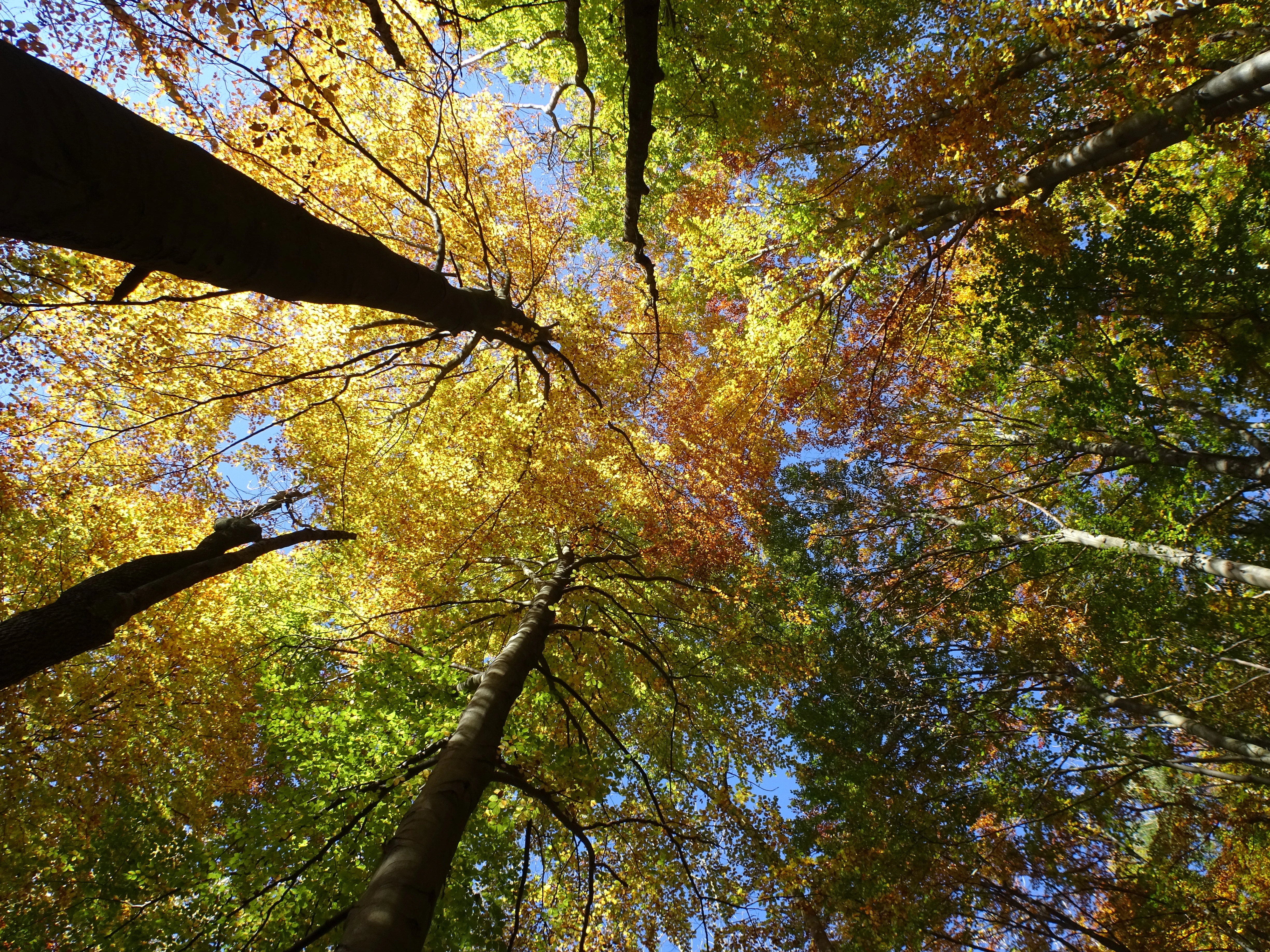
Kalkklippen südlich des Iberges nature reserve
A 47.3 hectare nature reserve in Bad Sooden-Allendorf, Hesse, established in 1995 and now part of the Kalkklippen der Gobert fauna-flora-habitat area.

Kalkklippen südlich des Iberges Nature Reserve history and protected-area timeline

The land that today forms the nature reserve has been part of the Allendorfer Stadtwald, the municipal forest of Bad Sooden-Allendorf, and has long been influenced by its position right on the Thuringian border. Its name and identity are firmly tied to the Iberg hill, whose name itself is derived from 'Eibe', the German word for European yew, a tree whose historical abundance in the Werra region was already remarked upon by the art historian and photographer Thomas Wiegand, who described the yew as the characteristic forest tree of the Werra landscape.

The first formal step toward protection came in October 1990, when the area was provisionally secured as an extension to the existing nature reserve 'Hessische Schweiz bei Meinhard'. On 25 September 1995, the Regierungspräsidium in Kassel formally designated the area under the name 'Kalkklippen südlich des Iberges' as a Naturschutzgebiet. The protection order was issued to preserve the orchid- and noble hardwood-rich limestone beech forests together with the limestone cliffs and boulder-rich steep slopes as habitat for rare and threatened plant and animal species.

In April 1999, the reserve was jointly reported with the neighboring 'Hessische Schweiz bei Meinhard' to the European Commission as the Fauna-Flora-Habitat site 'Kalkklippen der Gobert' under the EU Habitats Directive, formally incorporating it into the pan-European Natura 2000 network. In January 2023, the Hessian parliament adopted the law establishing the National Natural Monument 'Grünes Band Hessen', under which the entire reserve was integrated into Zone I of the monument and the contiguous biotope network. This placed the site within a cross-border ecological corridor that mirrors Thuringia's earlier 2018 designation of the 'Grünes Band' as a National Natural Monument.

Kalkklippen südlich des Iberges Nature Reserve landscape and geographic character

The landscape of Kalkklippen südlich des Iberges is shaped by the Muschelkalk ridge of the Gobert, a hill range that has been described as a Zeugenberg or even a small Zeugengebirge, separated from the original Thuringian basin margins by the Eichenberg-Gotha-Saalfeld fault system. The reserve sits on the northwestern edge of this geological structure, on the transition between the closed forested spur of the Gobert and the lower Werra hill landscapes to the west and south.

The terrain is defined by a striking contrast between dense forest cover and open, steep rock. The Muschelkalk escarpment rises in places with dramatic vertical cliffs and boulder-strewn slopes, created by mass-movement processes at the boundary between the Lower Muschelkalk limestone above and the clay-rich Röt formation below. Rainwater infiltrating the limestone's joints and fissures reaches the underlying clay, which swells and becomes plastic, setting the overlying rock mass in slow, downward motion.

This process has carved narrow ravines and gullies into the hillside, exposes fresh limestone rubble, and produces the block-rich talus slopes that today define much of the reserve's character. The most recent major events in the wider area occurred in 1956 at the Schickeberg and in 1985 at the Hörne, and ongoing fracturing in the limestone is interpreted as a sign that further slope failures may occur. The result is a visually unusual landscape for central Germany: an active, visibly moving hillside embedded within otherwise quiet, dense beech forest.
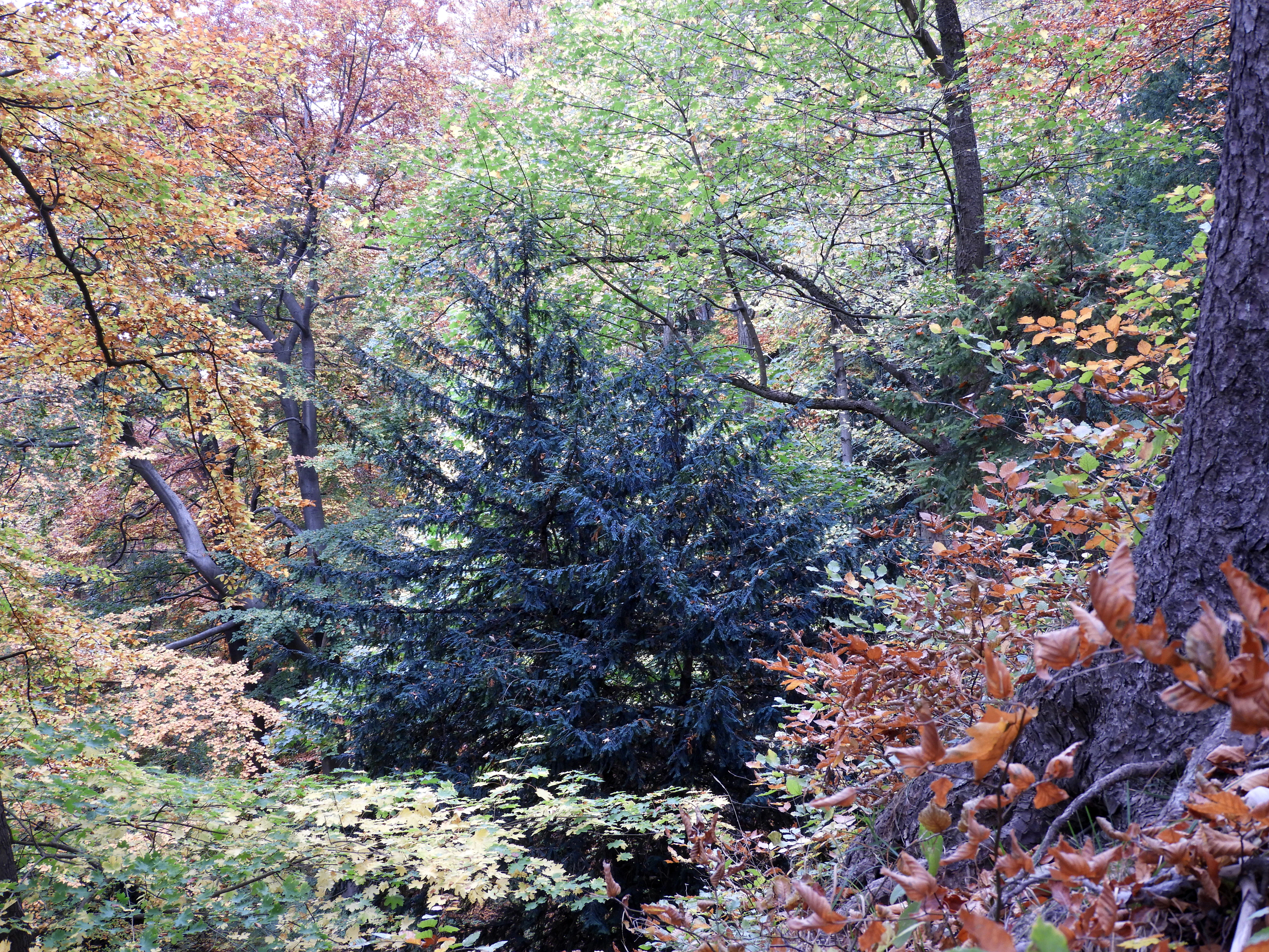
Kalkklippen sudlich des Iberges nature reserve
View of the Kalkklippen sudlich des Iberges nature reserve in the Werra-Meissner-Kreis, Hessen, a protected area established in 1995 for its native yew populations and limestone landscape.

Kalkklippen südlich des Iberges Nature Reserve ecosystems, habitats, and plant life

Ecologically, the reserve is dominated by closed forest. Two main beech forest communities define much of the area: the Waldmeister-Buchenwald (wood-rush and woodruff limestone beech forest) on moderately sloping sites, and the Orchideen-Kalk-Buchenwald (Central European orchid-rich limestone beech forest) on the warmer, calcareous, sun-exposed steep slopes. Below the rock walls, on calcareous scree and boulder fields, the vegetation passes into Ahorn-Linden-Hangschuttwald, a maple and linden slope-debris forest that grows on unstable, mobile substrate.

The orchid richness of these beech forests is a defining ecological feature. Species recorded include Frauenschuh (Cypripedium calceolus) and Fliegen-Ragwurz (Ophrys insectifera), together with various species of Waldvöglein (Cephalanthera), Knabenkräuter (Dactylorhiza, Orchis), and Stendelwurzen (Epipactis). The cliff and scree zones also support Blaugrasrasen (Sesleria albicans grasslands), which are interpreted as ice-age relict vegetation and host threatened plants such as Berg-Kronwicke, Garten-Schwarzwurzel, Traubige Graslilie, Erd-Segge, Braunrote Stendelwurz, Heilwurz, and Frühblühender Thymian. The Hessische Rote Liste also flags Berg-Distel, Gabeliges Habichtskraut, and Breitblättriges Laserkraut as extremely rare species within the reserve.

A second ecological signature is the dense population of European yew (Taxus baccata). Yew occurs here as an understory layer beneath the dominant beech canopy and is linked to the historical name of the Iberg hill. Although the species is nationally listed and protected under the Bundesnaturschutzgesetz, the Werra region and adjacent Eichsfeld host one of the most important remaining yew populations in Hesse, almost exclusively on calcareous soils. The combination of closed forest, open rock, and scree supports fauna associated with old woodlands, cliffs, and warm dry grasslands, and is a major reason for the site's value in the Natura 2000 network.

Kalkklippen südlich des Iberges Nature Reserve wildlife and species highlights

The reserve's wildlife value is closely tied to its mosaic of old beech forest, cliff, and open limestone grassland, and is explicitly cited in its Natura 2000 designation as well as in the adjacent protected areas. Within the reserve itself, precise species lists in the source are limited, but the habitat pattern supports woodland fauna typical of near-natural calcareous beech forests, as well as cliff- and scree-dwelling species along the Muschelkalk escarpment.

For the larger FFH-area 'Kalkklippen der Gobert' and the immediately adjacent Werra- und Wehretal FFH-site, two bat species are highlighted in the source: the Bechstein's bat (Myotis bechsteinii) and the greater mouse-eared bat (Myotis myotis). Both depend on structurally rich, old deciduous forest and adjacent open habitats, conditions that the reserve and its surroundings provide.

The adjacent Thuringian SPA 'Werrabergland südwestlich Uder' highlights the regional importance of the wider landscape for threatened bird species requiring special conservation measures and for regularly occurring migratory birds. Although the source does not enumerate detailed breeding or passage lists for the Kalkklippen reserve itself, its position within the Grünes Band ecological corridor and within these Natura 2000 sites places it firmly in a landscape of recognized ornithological and faunal significance.

Kalkklippen südlich des Iberges Nature Reserve conservation status and protection priorities

Kalkklippen südlich des Iberges is protected on multiple overlapping layers that together give it both national and European conservation significance. As a Naturschutzgebiet, it was designated in 1995 specifically to secure orchid- and noble hardwood-rich limestone beech forests, together with their associated cliffs and boulder-rich steep slopes, as habitats for rare and threatened plant and animal species.

Since 1999, the reserve has been part of the EU Natura 2000 network through the joint Fauna-Flora-Habitat site 'Kalkklippen der Gobert', which extends from about 300 m to 569 m in elevation and covers roughly 289 hectares. The justification for its EU designation explicitly cites the nationally important large-scale deciduous forest complex, the presence of yew populations, the Blaugras cliff grasslands, and the natural landslides as features of conservation value. In 2023, with the adoption of the National Natural Monument 'Grünes Band Hessen', the entire reserve was incorporated into Zone I of the monument, the zone intended to secure the undisturbed natural dynamics of ecosystems, including their collapse and pioneer phases.

This layered protection strategy combines strict-process exclusion of forestry on part of the forest, sustainable near-natural management on the rest, EU-level habitat protection, and integration into a cross-border biotope network along the former inner-German border. Beyond species protection, the conservation concept also preserves ongoing geomorphological processes, recognizing the active landslides themselves as a conservation feature that maintains open rock and pioneer habitat in a landscape that would otherwise progressively close into continuous forest.

Kalkklippen südlich des Iberges Nature Reserve cultural meaning and human context

The reserve is closely tied to the identity of Bad Sooden-Allendorf and its municipal forest, the Allendorfer Stadtwald, which has been in communal ownership for generations and forms part of the historic Werra region. The name of the adjacent Iberg itself is derived from 'Eibe', the German word for European yew, a tree deeply rooted in regional identity. The art historian and photographer Thomas Wiegand described the yew as the characteristic forest tree of the Werra landscape, an observation that has shaped how the area is perceived locally and how the reserve's ecological significance is framed.

The site's position directly on the former border between West and East Germany adds a second cultural dimension. The reserve lies on the line of the old inner-German border, and is integrated into the 'Grünes Band' (Green Belt) initiative, which has transformed what was once a militarized, restricted strip of land into a continuous corridor of protected nature from the North Sea to the Alps. Within Hesse, this corridor was formalized as a National Natural Monument in 2023, while the corresponding Thuringian Green Belt received the same status in 2018. The result is that the reserve is now part of a large, symbolically significant landscape project that links nature protection, Cold War memory, and cross-border regional identity between Hesse and Thuringia.

Top sights and standout views in Kalkklippen südlich des Iberges Nature Reserve

The reserve's most distinctive highlights include its active Muschelkalk landslide scars, considered among the most significant mass-movement areas in Hesse; its orchid-rich Central European limestone beech forest; and a regionally outstanding population of European yew growing as an understory layer beneath the beech canopy. Together, these give the site a strong, combined ecological and geological character that is relatively rare in central Germany.

Equally important is the layered protection framework: a 1995 Naturschutzgebiet, an EU Natura 2000 Fauna-Flora-Habitat site within 'Kalkklippen der Gobert', and full integration into Zone I of the National Natural Monument 'Grünes Band Hessen' in 2023. The reserve's location within the Geo-Naturpark Frau-Holle-Land and its position directly on the Thuringian border give it strong regional and cross-border significance as both a scientific and a landscape-conservation site.

Best time to visit Kalkklippen südlich des Iberges Nature Reserve

Spring and early summer are the most rewarding seasons for visiting Kalkklippen südlich des Iberges, when the limestone beech forests come alive with wildflowers and the orchid-rich slopes are most visible. Late spring is also the best time to observe the yew stands beneath the beech canopy, while the open Muschelkalk rock faces remain accessible and visually dramatic throughout the warmer months.

In wetter periods, the active landslide zones become particularly visible, as the geological processes that shape the cliffs are most pronounced when rainfall infiltrates the Muschelkalk joints and the underlying Röt clays swell. Autumn brings forest color to the beech canopy and a quieter atmosphere in the broader Grünes Band corridor. Winters are generally mild in the Werra valley but can make the steep cliff and scree slopes slippery and view conditions more limited. As the source notes, the area is only lightly accessed by trails, so visitors should expect a quiet, forest-oriented experience rather than a heavily developed visitor route.

Monthly climate preview

Long-term temperature ranges and monthly precipitation recorded at the representative coordinate

Kalkklippen südlich des Iberges Climate Normals and Annual Weather Patterns

Representative coordinates record measured multi-year temperature shifts alongside steady daily precipitation amounts across twelve distinct monthly periods. Examining the complete climate profile reveals detailed monthly fluctuations and long-term meteorological averages for the protected landscape.
Annual mean8 °C
-1 °C18 °C
Jan-1°
Feb
Mar
Apr
May12°
Jun16°
Jul18°
Aug18°
Sep14°
Oct
Nov
Dec
Warmest month
July

18.2 °C

Coolest month
January

-0.9 °C

Wettest month
July

2.6 mm/day

Driest month
April

1.5 mm/day

Park location guide

Geography guide, regional context, and park location map for Kalkklippen südlich des Iberges Nature Reserve

Kalkklippen südlich des Iberges Nature Reserve park geography, regions, and map view in Germany

Understand where Kalkklippen südlich des Iberges Nature Reserve sits in Germany through a broader geographic reading of the surrounding landscape, nearby location context, and its mapped position within the national park landscape.

How Kalkklippen südlich des Iberges Nature Reserve fits into Germany

Germany is a federal republic in Western and Central Europe with a population of over 83 million across sixteen constituent states. It is Europe's largest economy by nominal GDP and a major global exporter and importer. The capital is Berlin, and the country borders Denmark, Poland, Czech Republic, Austria, Switzerland, France, Luxembourg, Belgium, and the Netherlands.

Wider geography shaping Kalkklippen südlich des Iberges Nature Reserve in Germany

Germany is located in Western and Central Europe, spanning 357,022 km². It borders Denmark to the north, Poland and the Czech Republic to the east, Austria and Switzerland to the south, and France, Luxembourg, Belgium, and the Netherlands to the west. The country has coastlines on the Baltic Sea and North Sea to the north, with the Alps located in the southern region.

Map view of Kalkklippen südlich des Iberges Nature Reserve

Use this park location map to pinpoint Kalkklippen südlich des Iberges Nature Reserve in Germany, understand its exact geographic position, and read its mapped placement within the surrounding landscape more clearly.

Pigeon | © OpenStreetMap contributors

Location context for Kalkklippen südlich des Iberges Nature Reserve

Werra-Meißner-Kreis

Photographic reference for Muschelkalk escarpments, beech habitats, and protected terrain.

Visualizing Kalkklippen südlich des Iberges: Landscapes, Limestone Cliffs, and Forest Scenery

Visual documentation of Kalkklippen südlich des Iberges reveals the dramatic interplay between steep limestone cliffs, active landslide scars, and dense central European beech forest habitats. Photographic archives of the protected terrain illustrate the unique geological character and vegetation layers defining this escarpment landscape along the former border.

Kalkklippen südlich des Iberges nature reserve

Kalkklippen sudlich des Iberges nature reserve

Kalkklippen sudlich des Iberges nature reserve

Park atlas

Compare nearby protected areas and surrounding regional hill ecosystems

Parks Near Kalkklippen südlich des Iberges and Related Protected Landscapes

Browse other protected areas and nature reserves located near Kalkklippen südlich des Iberges in northern Hesse. Expanding the geographic comparison reveals connected regional hill landscapes and shared limestone conservation zones.
Nature reserveThuringia
About 0.1 km away#1 closest

Southeast

Stein, Rachelsberg, Gobert: A Protected Limestone Landscape in Western Thuringia

Mapping a historic nature reserve and beech forest complex

Stein, Rachelsberg, Gobert stands as a key protected area within Thuringia. This nature reserve offers deep insights into limestone ridge geography, historic border woodland continuity, and diverse habitats ranging from dry grasslands to tufa springs and orchid-rich beech forests.

Area
7.16 km²
Established
1999
IUCN
IV
Relief
Mountain
Nature reserveThuringia
About 2.4 km away#2 closest

North

Stein, Rachelsberg Nature Reserve: Mapped Muschelkalk Terrain in Thuringia

Protected low mountain hills and forested karst landscapes

The Stein, Rachelsberg nature reserve in Thuringia represents a protected mosaic of Muschelkalk ridges and Buntsandstein valleys. Its geography is defined by strongly broken relief, rocky outcrops, and a unique ring of forested summits including the Dieberg and Goburg, forming an essential link in regional conservation networks across the Thuringia and Hesse border.

Area
5.06 km²
Established
2023
Relief
Mountain
Climate
Temperate
Nature reserveThuringia
About 4.3 km away#3 closest

Northwest

Röhrsberg - Hasenwinkel - Mühlberg: Mapping the Protected Landscapes of Thuringia

Geological ridge systems and native forest habitat networks.

The Röhrsberg - Hasenwinkel - Mühlberg nature reserve represents a significant protected area in Thuringia, characterized by the juxtaposition of Muschelkalk limestone hills and Zechstein dolomite ridges. This site offers a concentrated view of regional terrain, shifting from closed beech forests to open juniper heaths. It serves as an essential geographic reference for understanding the ecological mosaic of the lower Werra hill country.

Area
4.51 km²
Established
1999
IUCN
IV
Relief
Upland
Nature reserveLandkreis Eichsfeld
About 6.6 km away#4 closest

Northwest

Hasenwinkel bei Fretterode: Protected Dolomite Ridge and Juniper Heath in Landkreis Eichsfeld

Nature reserve geography and landscape analysis

The Hasenwinkel bei Fretterode nature reserve is characterized by a prominent dolomite ridge rising above the agricultural lands of Landkreis Eichsfeld. This site offers an look at historically grazed calcareous grasslands and rocky outcrops. Our mapping covers its extent as a vital component of the regional protected-area network, showcasing its ecological importance and distinctive geology.

Area
0.062 km²
Established
1939
IUCN
IV
Relief
Upland
Nature reserveWerra-Meißner-Kreis
About 6.8 km away#5 closest

Southwest

Jestädter Weinberg: Protected Zechstein Cliffs and Werra River Valley Mosaic

A botanical and geological hotspot in northern Hesse

Jestädter Weinberg represents a critical protected landscape defined by its steep dolomite rock faces and sun-exposed slopes. This nature reserve provides an essential habitat for orchids and diverse insect populations, bridging the gap between high-altitude limestone ridges and the riparian meadows of the Werra river valley.

Area
0.6 km²
Established
1924
IUCN
IV
Relief
Upland
Nature reserveHessen
About 7.6 km away#6 closest

Southwest

Bilstein im Höllental: Protected Diabase Cliff and Ravine Forest in Hessen

Geological landscape and Natura 2000 protected area

Discover the geographic significance of Bilstein im Höllental, a nature reserve in the Werra-Meißner-Kreis that showcases a rare juxtaposition of warm rock refuges and cool, shaded ravine environments. The reserve protects significant cliff-dwelling plant communities and traces of medieval history upon its 284-meter diabase summit, providing a focused example of geological resistance shaping valley terrain.

Area
0.032 km²
Established
1960
IUCN
IV
Relief
Mountain
Nature reserveWerra-Meißner-Kreis
About 8 km away#7 closest

South

Mönchesrieth bei Grebendorf Nature Reserve in Werra-Meißner-Kreis, Germany

A restored wetland refuge in the Werra river floodplain.

Located in northern Hesse, Mönchesrieth bei Grebendorf is a protected nature reserve formed by the flooding of a former gravel extraction site. Its geography features a network of shallow bays and shoreline vegetation that provide essential nesting and foraging grounds for waterbirds within the busy Werra valley corridor. The site represents a successful transition from industrial terrain to a quiet, managed refuge for regional biodiversity.

Area
0.181 km²
Established
1999
IUCN
IV
Relief
Lowland
Nature reserveThuringia
About 8.1 km away#8 closest

North

Lengenberg Nature Reserve: A Geographical Overview of the Eichsfeld Ridge

Protected beech and yew woodlands in Thuringia, Germany

The Lengenberg Nature Reserve forms a prominent, fully forested ridge within the Eichsfeld region of Thuringia. Renowned for hosting one of the most substantial yew populations in central Europe, the reserve showcases a geological transition between shell limestone and red sandstone. This mapping of the terrain provides insight into the ecological structure of the Eichsfeld-Hainich-Werratal area.

Area
0.26 km²
Established
1961
Relief
Mountain
Climate
Temperate

Common questions about visiting, size, designation, and location context for Kalkklippen südlich des Iberges Nature Reserve

Kalkklippen südlich des Iberges Nature Reserve FAQs for park facts, access, geography, and protected area context

Find quick answers about Kalkklippen südlich des Iberges Nature Reserve, including protected-area facts, park geography, trail and visitor context, and how the park fits into its surrounding country and regional landscape.
MoriAtlas Explorer

Continue Your Protected Areas Search Across the Global Atlas

Deepen your exploration by continuing the structured search for national parks and protected areas worldwide. Utilize the comprehensive filtering capabilities to compare different conservation landscapes and refine your understanding of global park geography. Discover more about the distribution and characteristics of protected natural areas.

Global natural geography