
Mori Atlas logo
Nature reserveKalksandkiefernwald bei Bickenbach, Pfungstadt und Seeheim-Jugenheim

Understanding the rare calcareous sand pine forest and woodland heritage of central Hesse

Kalksandkiefernwald bei Bickenbach, Pfungstadt und Seeheim-Jugenheim Protected Landscape Geography

(Naturschutzgebiet 'Kalksandkiefernwald bei Bickenbach, Pfungstadt und Seeheim-Jugenheim')

This protected area in southern Hesse encompasses 87 hectares of light, open pine woodland established on lime-rich sandy soils. The reserve preserves a rare habitat type within the Rhine plain, featuring historical pasture trees and managed sand grass corridors. By integrating traditional grazing practices with modern conservation, the site serves as a vital sanctuary for specialized orchids, sand-loving flora, and diverse forest bird communities.

calcareous sand pine forestsandy soil woodlandopen pine forestpasture woodlandnature reservehabitat and species management
A flat-style digital illustration showing a winding path through a coniferous forest toward a waterfall in a mountain valley.

Kalksandkiefernwald bei Bickenbach, Pfungstadt und Seeheim-Jugenheim

Nature reserve

Park overview

Structured park overview, official facts, and landscape profile for Kalksandkiefernwald bei Bickenbach, Pfungstadt und Seeheim-Jugenheim

Kalksandkiefernwald bei Bickenbach, Pfungstadt und Seeheim-Jugenheim park facts, protected area profile, and essential visitor context

Review the core facts for Kalksandkiefernwald bei Bickenbach, Pfungstadt und Seeheim-Jugenheim, including designation, size, terrain, visitor scale, habitats, and operating context in one park-focused overview.

About Kalksandkiefernwald bei Bickenbach, Pfungstadt und Seeheim-Jugenheim

Kalksandkiefernwald bei Bickenbach, Pfungstadt und Seeheim-Jugenheim is a protected area devoted to one of the most threatened woodland types in the Rhine plain of central Germany: the calcareous sand pine forest. The reserve is situated in the Hessian section of the Upper Rhine lowlands, between the towns of Darmstadt, Pfungstadt, Seeheim, and Bickenbach. From a regional perspective, it lies within a transitional zone where the forested edge of the Bergstraße foothills meets the flat agricultural countryside of the Rhine plain, a setting that has historically supported open, sandy woodland habitats.

The nature reserve is notable for what it represents ecologically. Calcareous sand pine forests depend on a particular combination of substrate, light availability, and disturbance regime that has been steadily eroded by agricultural intensification, afforestation with non-native species, and the abandonment of traditional grazing practices. By formally protecting about 87 hectares of this habitat and imposing a management regime that maintains open conditions, the reserve helps safeguard a vegetation community that exists in only a few isolated localities across Hesse and neighboring regions.

Visitors and researchers value the site for its concentration of rare plants in a relatively small area, including several orchid species, sand violets, and characteristic herbs of the sand grass vegetation. The woodland also retains visible signs of its cultural history, with old pasture trees and juniper bushes speaking to centuries of grazing within what was otherwise a productive forest. Today the management philosophy combines modern ecological understanding with the continuation of this pastoral tradition, using livestock to keep the forest open and to sustain the very features that make the habitat distinctive.

Quick facts and research context for Kalksandkiefernwald bei Bickenbach, Pfungstadt und Seeheim-Jugenheim

The Kalksandkiefernwald bei Bickenbach covers about 87.42 hectares across three municipalities in the Darmstadt-Dieburg district of southern Hesse. It is classified as a Naturschutzgebiet under the German nature conservation framework and corresponds to IUCN Category IV, a habitat and species management area. The reserve was officially designated by ordinance on 23 January 1996 and carries the identifier 1432023, with World Database on Protected Areas entry 163992.

Geographically the area belongs to the Hessische Rheinebene, or Hessian Rhine plain, and forms part of the larger forest band between Darmstadt, Pfungstadt, and Seeheim-Jugenheim. The protected landscape is an open pine forest on calcareous sand, a habitat that has been heavily reduced elsewhere in the region. Conservation management emphasizes small-scale forestry and the use of livestock grazing to maintain the open woodland structure and prevent encroachment by shrubs.

Protection and recognition

Review documented terrestrial protection scope and recorded designation data for this protected area.

Protection Status and International Recognition for Kalksandkiefernwald bei Bickenbach, Pfungstadt und Seeheim-Jugenheim

Terrestrial protection records for Kalksandkiefernwald bei Bickenbach, Pfungstadt und Seeheim-Jugenheim outline the formal administrative scope and conservation status. Verified data profiles compile official designation details and registry identifiers to support transparent geographic analysis.

Protection details

Protection scope
Terrestrial
Transboundary protection
No
WDPA ID
163992
Park context

Deeper park guide and search-rich context for Kalksandkiefernwald bei Bickenbach, Pfungstadt und Seeheim-Jugenheim

Kalksandkiefernwald bei Bickenbach, Pfungstadt und Seeheim-Jugenheim history, landscape, wildlife, and travel context

Explore Kalksandkiefernwald bei Bickenbach, Pfungstadt und Seeheim-Jugenheim through its history, landscape character, ecosystems, wildlife, conservation priorities, cultural context, and seasonal travel timing in a structured park guide built for atlas discovery and search intent.

Why Kalksandkiefernwald bei Bickenbach, Pfungstadt und Seeheim-Jugenheim stands out

The reserve is best known for protecting a rare example of calcareous sand pine forest, a light, open woodland growing on lime-rich sandy soils that has largely disappeared from the surrounding agricultural lowlands of the Rhine plain. The site is notable for its combination of relict pasture trees, juniper shrubs, and a remarkably diverse understorey of specialized sand-loving plants. Old 'Hute' trees, shaped by historical grazing, still mark the woodland as a former pasture forest, while orchids, sand violets, and other rare herbs occupy the open ground. Equally distinctive is the active conservation approach used here. Grazing by goats, sheep, and donkeys is employed to suppress encroachment by blackthorn and bramble and to keep the soil open, a management strategy that links ecological preservation with the continuation of historical land use. The gas pipeline corridor in the smaller section has also been deliberately managed to develop a species-rich sand grass vegetation, showing how linear infrastructure zones can be integrated into conservation objectives.
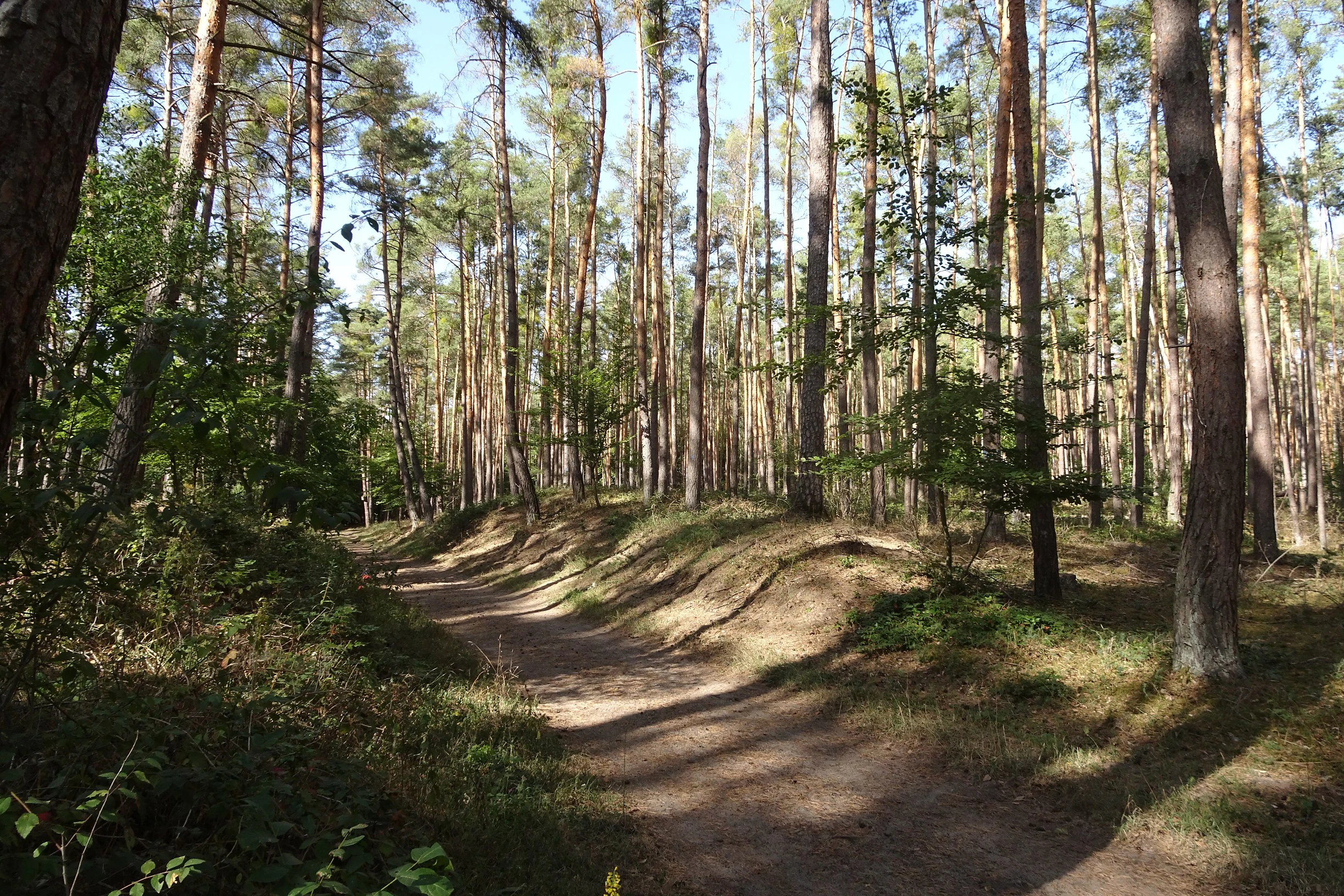
A sandy hiking path cuts through an open forest of tall, slender pine trees on sandy soil.
A light-filled, sandy path winds through the open pine forest of the Kalksandkiefernwald nature reserve.

Kalksandkiefernwald bei Bickenbach, Pfungstadt und Seeheim-Jugenheim history and protected-area timeline

The woodland protected today as Kalksandkiefernwald bei Bickenbach, Pfungstadt und Seeheim-Jugenheim has a long history shaped by human use. Old 'Hute' trees and the presence of juniper within the forest indicate that parts of the area were historically managed as a pasture forest, where livestock grazed among scattered trees, keeping the canopy open and the ground vegetation light-rich. This traditional Waldweide, or woodland grazing, practice shaped the open character of the pine forest long before modern nature conservation existed.

Over the course of the twentieth century, changes in land use across the Rhine plain increasingly threatened these open sand woodlands. Agricultural expansion, the spread of dense conifer plantations, and the decline of traditional grazing all contributed to shrub encroachment and habitat loss. By the late twentieth century, the site had become recognized as one of the few remaining examples of its habitat type in southern Hesse.

Formal protection came on 23 January 1996, when the area was designated as a Naturschutzgebiet by ordinance of the responsible regional authorities. The designation fixed the boundaries of the now roughly 87-hectare reserve and committed it to management as a habitat and species management area. In the decades since its establishment, the reserve has been actively managed using small-scale forestry techniques and grazing by goats, sheep, and donkeys, deliberately continuing elements of the site's pastoral past in order to preserve its unique ecological character.

Kalksandkiefernwald bei Bickenbach, Pfungstadt und Seeheim-Jugenheim landscape and geographic character

The landscape of the Kalksandkiefernwald is shaped by the gentle topography of the Hessian Rhine plain, a lowland region defined by sandy, lime-rich sediments left by ancient river and wind activity. Within this generally flat agricultural setting, the reserve forms a wooded enclave where soils remain sandy enough to support pine rather than the broadleaf forest typical of moister lowland sites. The terrain is gently undulating rather than steep, with subtle elevation changes related to dune relicts and former river channels.

Two distinct sections define the protected area. The larger southern section extends north of the village of Seeheim across the municipal boundaries of Seeheim-Jugenheim and Pfungstadt, terminating at the busy Bundesstraße 3 to the west. This is the broader, more consolidated part of the forest, where pine-dominated stands stretch across open sandy ground occasionally dotted with juniper and old pasture trees. The smaller northern section lies to the northeast of Bickenbach and northwest of Jugenheim, along the eastern edge of the Bickenbach municipal area. Here the landscape is interrupted by a cleared gas pipeline corridor, a linear feature that has itself become a valued habitat for sand grass vegetation thanks to targeted management.

Across both sections, the woodland is distinctly open and light-filled, contrasting with the denser, darker forests more typical of Hesse. The combination of calcareous sand substrate, low-intensity historical land use, and ongoing management gives the area its characteristically airy, semi-open appearance, with widely spaced pine trees, patches of grassland between them, and clearings that allow sun-loving plants to thrive.
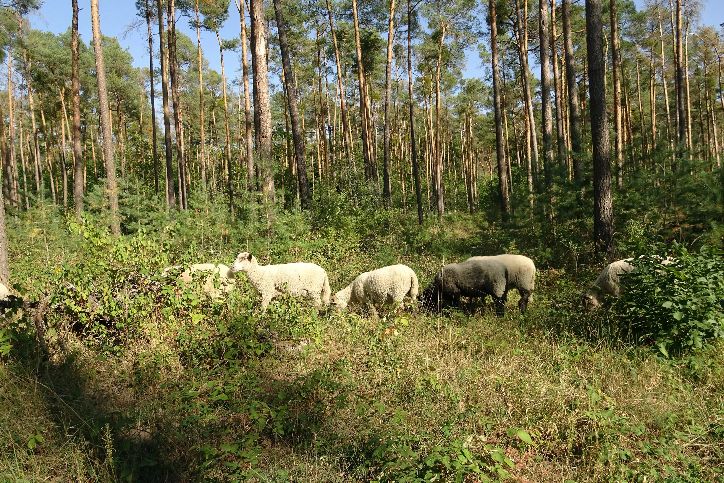
A small group of sheep grazing in a sparse, open pine forest with sandy ground covered in low-lying green shrubs.
Sheep grazing in the pine forest of the Kalksandkiefernwald nature reserve.

Kalksandkiefernwald bei Bickenbach, Pfungstadt und Seeheim-Jugenheim ecosystems, habitats, and plant life

Ecologically the reserve belongs to a narrow category of habitats known as calcareous sand pine forests, a community that requires calcareous sandy soils, abundant light, and a regime of disturbance that prevents aggressive shrubs from dominating. The stand structure is dominated by pine, with an understorey that includes both relict woodland species and open-ground specialists that would normally be excluded from denser forest. The result is a transitional ecosystem that mixes features of dry grasslands with elements of light woodland.

The understorey of the Kalksandkiefernwald is exceptionally rich for its size. Characteristic species include hair broom grass, perennial flax, dwarf medick, steppe spurge, rockrose, wintergreen, sand violet, and sand silver thistle, alongside several orchid species and the grey scabious. These plants are typical of warm, dry, sandy environments and indicate a habitat of considerable conservation value in the regional context. The cleared pipeline corridor in the smaller section has been deliberately managed to develop a similar sand grass community, demonstrating how additional open sandy areas can reinforce the overall habitat network.

Vegetation patterns in the reserve reflect its history as a pasture woodland. Pasture trees and juniper bushes are scattered through the stands, marking former grazing areas and creating a mosaic of microhabitats that supports different plant and insect communities. This combination of woodland and open-ground elements within a single small area gives the Kalksandkiefernwald a layered ecological structure unusual for the intensively used agricultural lowlands around it.

Kalksandkiefernwald bei Bickenbach, Pfungstadt und Seeheim-Jugenheim wildlife and species highlights

The wildlife value of the Kalksandkiefernwald lies primarily in the bird community adapted to its open, light-rich pine woodland habitat. Breeding species recorded in the reserve include the tree pipit, a ground-nesting songbird that depends on the kind of open forest structure maintained here, as well as the wood warbler and the pied flycatcher, both of which favor mature broadleaf and mixed woodland with semi-open conditions. The presence of these species alongside grazing livestock and a rich understorey of insects and herbs suggests a functioning ecological community rather than just a collection of isolated stands.

The diverse ground vegetation, including flowering herbs and orchids, supports a range of pollinators and other invertebrates. The maintenance of open sandy patches, partly through grazing by goats, sheep, and donkeys, sustains the warm microclimate required by many sand-dwelling insects, which in turn provide food for birds and small mammals. Old pasture trees with cavities and deadwood add further habitat complexity for insects and cavity-nesting species.

While the reserve is small, its mosaic of open pine forest, juniper patches, and sand grassland creates niche diversity within a landscape that is otherwise dominated by farmland and denser forest. For this reason it functions as an important refugium for species that depend on the specific conditions of the calcareous sand ecosystem, including specialists that have disappeared from much of the surrounding region.

Kalksandkiefernwald bei Bickenbach, Pfungstadt und Seeheim-Jugenheim conservation status and protection priorities

The primary conservation goal of the Kalksandkiefernwald reserve is the long-term preservation of the calcareous sand pine forest as a habitat for the rare plant and animal communities adapted to it. By giving the area formal protected status in 1996, the regional authorities recognized both its rarity in the Hessian Rhine plain and the pressure from land-use change that had been degrading similar habitats for decades. The reserve is managed under IUCN Category IV standards, emphasizing active habitat and species management rather than purely passive protection.

Management practices are tailored to the ecological requirements of the habitat. Small-scale forestry is used to maintain a woodland in which pine remains dominant, while livestock grazing by goats, sheep, and donkeys is employed to suppress encroachment by blackthorn and bramble. By keeping the canopy and understorey open, this grazing mimics the historical disturbance regime that originally shaped the woodland and supports the sun-loving plant species that define it. Even the gas pipeline corridor cutting through the smaller section has been integrated into conservation, with targeted management promoting a species-rich sand grass vegetation.

The broader conservation significance of the site lies in its role as one of the few surviving examples of its habitat type in the densely populated Rhine-Main region. Protecting such a habitat helps maintain regional biodiversity, supports ecological connectivity between remaining sandy sites, and preserves a reference example of traditional pasture woodland. For these reasons, the reserve is considered a valuable component of the protected-area network in Landkreis Darmstadt-Dieburg and in southern Hesse more generally.

Kalksandkiefernwald bei Bickenbach, Pfungstadt und Seeheim-Jugenheim cultural meaning and human context

The Kalksandkiefernwald is not only an ecological site but also a cultural landscape with roots in centuries of traditional land use. The presence of old 'Hute' trees and juniper bushes reflects the historical practice of Waldweide, where livestock grazed within the forest and shaped its open character. This kind of pasture woodland was once a common feature of the Rhine plain, where forests served multiple purposes, providing timber, fodder, and grazing at the same time.

The continuation of grazing within the modern reserve, using goats, sheep, and donkeys, consciously preserves this cultural tradition as part of the conservation approach. In doing so, the site connects present-day biodiversity management with the agricultural and forestry practices of earlier centuries, ensuring that the cultural as well as the natural value of the landscape is maintained. The reserve thus serves as a small but meaningful repository of regional land-use heritage within an otherwise heavily modernized lowland environment.

Top sights and standout views in Kalksandkiefernwald bei Bickenbach, Pfungstadt und Seeheim-Jugenheim

The reserve's most distinctive quality is the concentration of rare calcareous-sand-loving plants within a small pine woodland, including several orchid species, sand violets, and characteristic sand grass vegetation. Equally notable is the integration of historical grazing practices into modern conservation, with livestock actively used to maintain the open character that supports the habitat's specialist species.

Best time to visit Kalksandkiefernwald bei Bickenbach, Pfungstadt und Seeheim-Jugenheim

The Kalksandkiefernwald is most rewarding to experience during the warmer months, when the open pine canopy allows sunshine to reach the ground and bring out the richest display of sand-loving wildflowers, including several orchids. Spring and early summer are typically the best seasons for observing flowering understorey plants, while daytime visits in late spring and early summer also offer the best chance to hear breeding woodland birds such as the tree pipit. Autumn brings cooler, calmer conditions under the pines and can be pleasant for quieter exploration, although some flowering species will have finished by then. As a small lowland forest reserve, the site is generally less atmospheric in winter, when the largely deciduous understorey loses color and many birds are silent or absent.

Monthly climate preview

Long-term monthly temperature and precipitation records measured from representative park coordinates in Hesse

Climate Normals and Average Temperature for Kalksandkiefernwald bei Bickenbach, Pfungstadt und Seeheim-Jugenheim

Representative coordinates track measured monthly temperature swings from freezing winter lows to warm summer maximums alongside consistent year-round precipitation averages. Accessing the complete twelve-month climatology profile allows detailed comparison of historical temperature ranges and precipitation metrics across the protected landscape.
Annual mean10 °C
0 °C21 °C
Jan
Feb
Mar
Apr10°
May14°
Jun18°
Jul21°
Aug20°
Sep15°
Oct10°
Nov
Dec
Warmest month
July

20.6 °C

Coolest month
January

0.2 °C

Wettest month
July

2.2 mm/day

Driest month
April

1.4 mm/day

Park location guide

Geography guide, regional context, and park location map for Kalksandkiefernwald bei Bickenbach, Pfungstadt und Seeheim-Jugenheim

Kalksandkiefernwald bei Bickenbach, Pfungstadt und Seeheim-Jugenheim park geography, regions, and map view in Germany

Understand where Kalksandkiefernwald bei Bickenbach, Pfungstadt und Seeheim-Jugenheim sits in Germany through a broader geographic reading of the surrounding landscape, nearby location context, and its mapped position within the national park landscape.

How Kalksandkiefernwald bei Bickenbach, Pfungstadt und Seeheim-Jugenheim fits into Germany

Germany is a federal republic in Western and Central Europe with a population of over 83 million across sixteen constituent states. It is Europe's largest economy by nominal GDP and a major global exporter and importer. The capital is Berlin, and the country borders Denmark, Poland, Czech Republic, Austria, Switzerland, France, Luxembourg, Belgium, and the Netherlands.

Wider geography shaping Kalksandkiefernwald bei Bickenbach, Pfungstadt und Seeheim-Jugenheim in Germany

Germany is located in Western and Central Europe, spanning 357,022 km². It borders Denmark to the north, Poland and the Czech Republic to the east, Austria and Switzerland to the south, and France, Luxembourg, Belgium, and the Netherlands to the west. The country has coastlines on the Baltic Sea and North Sea to the north, with the Alps located in the southern region.

Map view of Kalksandkiefernwald bei Bickenbach, Pfungstadt und Seeheim-Jugenheim

Use this park location map to pinpoint Kalksandkiefernwald bei Bickenbach, Pfungstadt und Seeheim-Jugenheim in Germany, understand its exact geographic position, and read its mapped placement within the surrounding landscape more clearly.

Pigeon | © OpenStreetMap contributors

Location context for Kalksandkiefernwald bei Bickenbach, Pfungstadt und Seeheim-Jugenheim

Hesse

Visualizing the rare calcareous sand pine forest habitats and sandy woodland terrain of southern Hesse

Kalksandkiefernwald bei Bickenbach, Pfungstadt und Seeheim-Jugenheim Photos and Landscape Scenery

Visual documentation reveals the open pine canopy, light-filled clearings, and specialized sand-dwelling flora characteristic of the reserve. Examining these protected area views helps researchers understand the rare calcareous soils and historical pastoral woodland structures defining the Upper Rhine region.

A sandy hiking path cuts through an open forest of tall, slender pine trees on sandy soil.

A triangular green nature reserve sign on a wooden post stands in a sparse pine forest with a dirt path winding through the trees.

A small group of sheep grazing in a sparse, open pine forest with sandy ground covered in low-lying green shrubs.

Park atlas

Compare surrounding protected areas and regional woodland reserves across the Hessian Rhine plain.

Exploring Parks Near Kalksandkiefernwald bei Bickenbach, Pfungstadt und Seeheim-Jugenheim

Visitors concluding their review of Kalksandkiefernwald bei Bickenbach, Pfungstadt und Seeheim-Jugenheim can browse adjacent nature reserves and sandy woodland habitats throughout the surrounding region. Examining these neighboring protected landscapes provides broader geographic context for lowland pine ecosystems and specialized conservation areas.
A pale, soft-toned watercolor painting showing rolling green and golden dunes under a light, hazy sky.
Nature reserveHessen
About 3 km away#1 closest

North

Düne am Ulvenberg von Darmstadt-Eberstadt: Inland Sand Dune Protected Area Geography

A rare Pleistocene dune ecosystem in the Hessen region.

Düne am Ulvenberg von Darmstadt-Eberstadt represents a critical inland dune fragment within the Upper Rhine Graben. This nature reserve provides essential habitat for sand-dwelling flora in a setting defined by its open, dry sandy flats, pine woodland, and specialized steppe-like turf that persists as a unique geological legacy.

Area
0.089 km²
Established
1991
IUCN
IV
A watercolor landscape illustration showing a winding stream, marsh grasses, and trees with soft rolling hills in the background, set against a pale background.
Nature reserveHessen
About 3.1 km away#2 closest

West

Pfungstädter Moor Nature Reserve: Hessian Wetland and Ancient River Landscape

Protected wetland area in the Hessian Rhine plain

This nature reserve encompasses a rare silted-up segment of the ancient Neckar river, forming a complex of reed beds, alder carr, and peat bog habitats. Managed through creative restoration techniques that lift Rhine water into the moor, the landscape remains a vital ecological sanctuary in the heart of Hesse, standing in sharp contrast to the surrounding agricultural terrain.

Area
0.97 km²
Established
1955
IUCN
IV
Relief
Lowland
A soft watercolor painting of a flat, open landscape with scattered trees, rolling grasses, and muted green and pink tones.
Nature reserveHessen
About 3.4 km away#3 closest

North

Lerchenberg und Kernesbellen von Darmstadt-Eberstadt: Hessian Nature Reserve and Dune Atlas

Protected sand grassland and pine forest landscape mapping

Lerchenberg und Kernesbellen von Darmstadt-Eberstadt serves as a key inland dune reserve within the northern Upper Rhine Plain. This protected area features a unique, sun-warmed mosaic of sandy substrates, sparse calcareous forests, and historic orchard meadows. Analyze the site's ecological boundaries and its role as a critical habitat fragment within the broader network of regional protected landscapes.

Area
0.172 km²
Established
1995
IUCN
IV
A horizontal watercolor illustration of a soft, hazy landscape featuring light pink blooming trees in a green field, with rolling, misty purple and brown hills in the background.
Nature reserveHesse
About 4.3 km away#4 closest

Southeast

Fuchswiese bei Stettbach: Mapped Nature Reserve and Protected Meadow Landscape in Hesse

Exploring the ecological boundaries of a specialized wet meadow reserve in southern Hesse

Fuchswiese bei Stettbach is a dedicated nature reserve serving as a critical habitat for threatened meadow butterfly species. Located in the Darmstadt-Dieburg district of Hesse, this protected area preserves wet meadow vegetation amidst the northern Odenwald fringe. The site offers a focused view into how small, carefully managed landscapes contribute to the broader ecological health and regional geography of central Germany.

Area
0.03 km²
Established
2010
A watercolor painting showing a soft, stylized landscape of green meadows, sparse trees, and distant rolling hills against a white background.
Nature reserveHesse
About 4.8 km away#5 closest

Southwest

Im Dulbaum bei Alsbach Nature Reserve: Mapped Inland Dunes and Grassland Geography

A vital protected sandy terrain in the Hessian Rhine Plain

Im Dulbaum bei Alsbach protects a remnant of the historic Rhine graben sand dune belt in southern Hesse. This nature reserve provides essential habitat connectivity for heat-loving species through its distinct calcareous sand grasslands and former quarry terrain, offering a look into the region's complex ecological history.

Area
0.092 km²
Established
1994
IUCN
IV
Relief
Lowland
A soft, delicate watercolor painting depicting a meandering river flowing through a lush, grassy wetland landscape with rolling hills in the background.
Nature reserveHessen
About 5.3 km away#6 closest

Southwest

Altneckarlachen von Alsbach, Hähnlein und Bickenbach: Protected Wetland and River Geography

A rare mosaic of prehistoric river loops in the Hessian Rhine plain

Altneckarlachen von Alsbach, Hähnlein und Bickenbach protects a unique sequence of prehistoric Neckar meanders featuring shallow water zones, reed belts, and black-alder swamp forest. This nature reserve in the Darmstadt-Dieburg district remains a critical wetland sanctuary, preserving a vital ecological cross-section of the ancient Rhine-Neckar landscape and its associated peatland soils.

Area
0.892 km²
Established
1990
IUCN
IV
Relief
Lowland
A soft watercolor painting of a rolling green hillside with trees, set against a pale, light-colored background.
Nature reserveHessen
About 6.5 km away#7 closest

South

Orbishöhe von Auerbach und Zwingenberg: Geography, Landscape, and Protected Area Mapping

An examination of Hessian quarry-based ecological conservation sites.

The Orbishöhe von Auerbach und Zwingenberg nature reserve serves as a prime example of localized conservation within the Odenwald hills. Its landscape is defined by former quarry faces and open slope terraces, which provide a critical habitat for rare and threatened plant species. This resource offers a clear look at the reserve's topography, physical boundaries, and its broader role within the Natura 2000 network of protected German lands.

Area
0.064 km²
Established
1988
Watercolor painting showing a stylized, panoramic landscape of rolling hills and forest, depicted in soft green and earth tones against a white background.
Nature reserveHessen
About 6.7 km away#8 closest

Southeast

Felsberg bei Reichenbach Nature Reserve: Geography and Granite Boulder Field Analysis

Protected forest and geological monument in the Odenwald range

Felsberg bei Reichenbach protects 168 hectares of Odenwald mountain slope in Southern Hessen. The site is centered on the Felsenmeer, a dramatic sea of granite boulders created by frost weathering, framed by mixed deciduous woodland. This area functions as an important Natura 2000 habitat, preserving both specialized rock ecosystems and montane forest, providing a clear geographic link between the Lautertal valley and the high slopes of the Felsberg summit.

Area
1.677 km²
Established
1972
IUCN
IV
Relief
Mountain

Common questions about visiting, size, designation, and location context for Kalksandkiefernwald bei Bickenbach, Pfungstadt und Seeheim-Jugenheim

Kalksandkiefernwald bei Bickenbach, Pfungstadt und Seeheim-Jugenheim FAQs for park facts, access, geography, and protected area context

Find quick answers about Kalksandkiefernwald bei Bickenbach, Pfungstadt und Seeheim-Jugenheim, including protected-area facts, park geography, trail and visitor context, and how the park fits into its surrounding country and regional landscape.
MoriAtlas Explorer

Continue Your Protected Areas Search Across the Global Atlas

Deepen your exploration by continuing the structured search for national parks and protected areas worldwide. Utilize the comprehensive filtering capabilities to compare different conservation landscapes and refine your understanding of global park geography. Discover more about the distribution and characteristics of protected natural areas.

Global natural geography