Mori Atlas logo
Wildlife reserveKalmiopsis Wilderness

Exploring the serpentine geology, river headwaters, and diverse botanical terrain of southwestern Oregon

Kalmiopsis Wilderness: An In-Depth Geographic Profile of the Klamath Mountains Protected Landscape

Kalmiopsis Wilderness serves as a significant protected landscape within the Klamath Mountains of southwestern Oregon. This expansive wilderness area encompasses deeply carved river canyons, sharp ridgelines, and clear mountain streams that define its rugged topography. Characterized by unusual ultramafic soils and rare botanical life, including the namesake Kalmiopsis leachiana, the area provides a window into complex geological formations and long-term post-fire ecological recovery.

Klamath Mountainswilderness areaserpentine geologyultramafic soilsbotanical diversitywild and scenic rivers

Kalmiopsis Wilderness

Wildlife reserve

Park overview

Structured park overview, official facts, and landscape profile for Kalmiopsis Wilderness

Kalmiopsis Wilderness park facts, protected area profile, and essential visitor context

Review the core facts for Kalmiopsis Wilderness, including designation, size, terrain, visitor scale, habitats, and operating context in one park-focused overview.

About Kalmiopsis Wilderness

Kalmiopsis Wilderness occupies a central place in the Klamath Mountains of southwestern Oregon, a region long recognized for its geological complexity, botanical richness, and rugged scenery. The wilderness lies within the Rogue River – Siskiyou National Forest and was placed into the National Wilderness Preservation System by the United States Congress in 1964, anchoring decades of protected status on lands that had previously supported mining, settlement, and small-scale resource extraction. The area crosses Curry and Josephine counties and is closely associated with the nearby community of Cave Junction.

Geographically, the wilderness is defined by the meeting of steep terrain and water. River canyons cut deeply through the mountains, while the headwater basins of the Chetco, North Fork Smith, and Illinois Rivers all originate within or near the protected boundary. These rivers carry National Wild and Scenic River designations, underscoring the watershed significance of the area. Elevations climb from around 500 feet in the lower canyon country to nearly 5,100 feet at Pearsoll Peak, producing a striking range of microclimates and vegetation zones across a relatively contained footprint.

The wilderness is also notable for its trail network, with around 24 maintained hiking routes that collectively contribute more than 150 miles of backcountry travel opportunities. These trails link former mining localities, river corridors, and high ridgelines, giving visitors a way to experience both the natural and the historical character of the area. Although wildfires in 2002 and 2017 damaged large portions of the trail system and the surrounding forest, ongoing rehabilitation has restored access across many of the original routes.

Set against this physical backdrop, the Kalmiopsis identity is strongly tied to its unusual plant life and the geology that supports it. The wilderness’s combination of serpentine, ultramafic, and sedimentary substrates produces challenging soil conditions that, paradoxically, generate exceptional botanical diversity. It is this intersection of rugged landforms, rare flora, fire-shaped recovery, and protected river headwaters that gives the Kalmiopsis its durable sense of place within the Pacific Northwest.

Quick facts and research context for Kalmiopsis Wilderness

Kalmiopsis Wilderness sits in the Klamath Mountains of southwestern Oregon and is administered by the United States Forest Service through the Rogue River – Siskiyou National Forest. Its 1964 wilderness designation made it one of the early entries in the National Wilderness Preservation System, and the protected area now spans Curry and Josephine counties near the small town of Cave Junction. The landscape ranges from low, forested river basins to high rocky peaks, anchored by the headwaters of the Chetco, Illinois, and North Fork Smith Rivers, all of which carry National Wild and Scenic River designations. Geologically, the area includes iron- and magnesium-rich ultramafic rocks and ancient serpentine formations that support unusually diverse and specialized plant communities. Botanically, it is defined by Kalmiopsis leachiana, a slow-growing rhododendron relative discovered in 1930 and considered a relict species from before the last ice age.

Protection and recognition

Analysis of terrestrial conservation frameworks, management scope, and recognition data.

Kalmiopsis Wilderness Protection Status and Documented Protected Area Designation

Kalmiopsis Wilderness maintains a documented terrestrial protection status within official conservation frameworks. Official records assemble baseline designation details and management scope for territorial evaluation.

Protection details

Protection scope
Terrestrial
Transboundary protection
No
Park context

Deeper park guide and search-rich context for Kalmiopsis Wilderness

Kalmiopsis Wilderness history, landscape, wildlife, and travel context

Explore Kalmiopsis Wilderness through its history, landscape character, ecosystems, wildlife, conservation priorities, cultural context, and seasonal travel timing in a structured park guide built for atlas discovery and search intent.

Why Kalmiopsis Wilderness stands out

Kalmiopsis Wilderness is most recognized for the unusual botanical richness that arises from its geology, especially the interplay between serpentine and ultramafic soils and the diverse plant communities they support across widely varying elevations. It is the namesake of Kalmiopsis leachiana, a rare and slow-growing member of the Ericaceae family that survives as a botanical relict from before the Pleistocene glaciations. Equally distinctive is the wilderness’s character as a deeply dissected mountain landscape of sharp ridges, steep canyons, and clear rivers, threaded by more than 150 miles of trails. The combined record of large wildfires, particularly in 2002 and 2017, has also made the area a focus of interest for observing long-term post-fire recovery and plant succession on unusual substrates.

A close up view of several small pink Kalmiopsis leachiana flowers against a soft, out of focus blue background.
The rare Kalmiopsis leachiana, an endemic shrub and the namesake of the Kalmiopsis Wilderness.

Kalmiopsis Wilderness history and protected-area timeline

The human history of the Kalmiopsis area stretches back into the nineteenth century, when the Klamath Mountains became a stage for small-scale gold mining. Gold was discovered in the area around 1850, drawing prospectors into the rugged canyons and initiating a regional gold rush that left a visible mark on the landscape in the form of mining towns, hard rock mines, cabin sites, water ditches, and tailings. At its peak, more than a dozen mines operated here, and a network of settlements supported the miners and their families. People continued to live and work in the area into the mid-twentieth century, and as late as 1962 many of the original homes, stores, and pieces of mining equipment were still standing in place.

The end of the extractive era came in 1964, when Congress designated the Kalmiopsis as a wilderness area, formally placing the landscape under the protective framework of the National Wilderness Preservation System. This designation shifted the region’s identity from a working mining district to a protected backcountry landscape, opening the door to trail-based recreation and long-term ecological preservation. Botanical exploration had already added a new dimension to the area’s significance by 1930, when Lilla Leach discovered Kalmiopsis leachiana in the Gold Basin area, a small, slow-growing plant that would eventually give the wilderness its name.

The modern era of the Kalmiopsis has been defined as much by fire as by protection. In 2002, lightning ignited the Biscuit Fire, which burned nearly half a million acres across southwestern Oregon and scorched essentially the entire wilderness. Trails were damaged, vegetation was reset across a vast area, and the wilderness became an active site for observing post-fire succession on unusual substrates. Some of the destroyed trail segments did not reopen until 2015. The 2017 Chetco Bar Fire again burned large portions of the area, compounding the disturbance and creating a landscape shaped by overlapping fire histories. Today, the Kalmiopsis stands as both a protected wilderness and a working example of how its distinctive plant communities recover from repeated large-scale fire events.

Kalmiopsis Wilderness landscape and geographic character

The Kalmiopsis Wilderness is defined by the vertically dramatic terrain typical of the Klamath Mountains, where deep river canyons, sharp ridgelines, and exposed rocky summits produce a constantly shifting topographic backdrop. Elevations climb from roughly 500 feet in the lower canyons to 5,098 feet at Pearsoll Peak, the wilderness’s high point, creating a notable contrast between warm low-elevation river valleys and the cooler, exposed slopes and ridges above. Steep canyon walls, knife-edge ridges, and clear, fast-running mountain streams together shape the visual and physical character of the area.

Rivers play a defining role in the landscape. The wilderness includes the headwater basins of the Chetco, the North Fork Smith, and significant portions of the Illinois River canyon. Each of these rivers has been designated under the National Wild and Scenic Rivers system, recognizing both their ecological value and their role in shaping the deep canyons through which they flow. Their water, gathered from the higher elevations of the wilderness, supports downstream ecosystems well beyond the protected boundary.

The wilderness’s surface geology also contributes directly to the visible landscape. Much of the eastern portion sits on the Josephine ultramafic sheet, an iron- and magnesium-rich formation that supports a distinctive terrain, while the western portion rests on sedimentary rocks of the Dothan formation and the igneous intrusive rocks of the Big Craggies. Together, these formations produce striking outcrops, unusual soil chemistry, and a pattern of exposed ridges and benches, including well-known features such as Serpentine Ridge, that visually set the Kalmiopsis apart from more typical forested Pacific Northwest terrain.
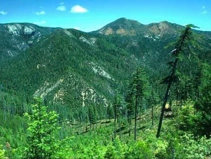
A mountainous landscape covered in dense green coniferous forest under a clear blue sky, with visible ridgelines and slopes.
A wide view of the rugged, forested mountains within the Kalmiopsis Wilderness in southwestern Oregon.

Kalmiopsis Wilderness ecosystems, habitats, and plant life

The ecological identity of the Kalmiopsis Wilderness emerges from the unusual overlap of varied topography and unusual geology, producing conditions that favor rare and specialized plant communities. The combination of ultramafic substrates, serpentine formations, sedimentary rocks, and intrusive igneous materials, along with elevations ranging from canyon bottoms to high peaks, creates an unusually broad range of microhabitats within a relatively compact area. This diversity drives the botanical richness for which the wilderness is so widely known.

The most iconic species in the area is Kalmiopsis leachiana, a small, slow-growing plant in the Ericaceae family that is considered a relict from before the last ice age. First discovered in 1930 by Lilla Leach in the Gold Basin area, it survives in scattered populations across the wilderness and remains the namesake of the protected landscape. Beyond this rare anchor species, the Kalmiopsis supports a wide variety of woody and herbaceous plants adapted to its diverse soils and elevations, including communities that respond to fire in distinctive ways.

Large-scale disturbance has become a central feature of the wilderness’s modern ecology. The 2002 Biscuit Fire burned essentially the entire wilderness, followed by significant reburning during the 2017 Chetco Bar Fire. Together, these events reset large sections of the vegetation, opened the canopy, and exposed soils across the landscape. The result is an area in active recovery, where plant succession, erosion, sediment redeposition, and shifting habitat conditions can be observed across overlapping fire histories. The Kalmiopsis is therefore not only a refuge for rare plants but also a living laboratory for understanding how fire interacts with unusual geology over time.

Kalmiopsis Wilderness wildlife and species highlights

The Kalmiopsis Wilderness supports wildlife patterns shaped by its deep canyons, elevation range, and post-fire forest structure. The mix of mature forest, recently burned landscapes, river corridors, and rocky ridges provides habitat for species typical of southwestern Oregon’s Klamath Mountains region. Riparian zones along the Chetco, Illinois, and North Fork Smith Rivers concentrate wildlife activity, while the regenerating forests of the Biscuit and Chetco Bar Fire areas offer younger structural habitat for species adapted to early successional environments.

Although detailed species inventories fall outside the scope of this profile, the wilderness is widely associated with the broader wildlife communities of the Rogue River – Siskiyou National Forest, including deer, black bear, and a variety of smaller mammals, as well as birdlife typical of mixed-conifer and oak-influenced forests of southwestern Oregon. The river systems in and around the Kalmiopsis also contribute to freshwater habitat values for fish and aquatic species. Ongoing post-fire vegetation changes continue to reshape habitat availability for many of these species, making the area an active setting for ecological observation and research.

Kalmiopsis Wilderness conservation status and protection priorities

Kalmiopsis Wilderness plays a significant role in the conservation landscape of the Pacific Northwest, both for its biodiversity and for its watershed values. Its 1964 designation as part of the National Wilderness Preservation System placed durable federal protection on a large block of Klamath Mountains terrain, preserving it from logging, roadbuilding, and other forms of development. The wilderness’s headwaters feed rivers that carry National Wild and Scenic River designations, extending the conservation significance of the area well beyond its own boundary.

A major element of the Kalmiopsis’s conservation importance is the unusual flora supported by its ultramafic and serpentine soils, including Kalmiopsis leachiana itself, a botanical relict that depends on the specific conditions protected within the wilderness. By maintaining a broad range of elevations and substrate types, the area safeguards a portfolio of plant communities that are difficult or impossible to preserve elsewhere.

The repeated large wildfires of 2002, 2017, and surrounding years have added a new dimension to conservation work in the area. While these fires temporarily altered vegetation across nearly the entire wilderness, they have also opened opportunities for monitoring long-term post-fire recovery, plant succession, and erosion dynamics on unusual soils. Trail rehabilitation, watershed protection, and invasive species monitoring have become central to ongoing stewardship, and the Kalmiopsis now serves as both a refuge for rare species and a key reference site for fire ecology research in southwestern Oregon.

Kalmiopsis Wilderness cultural meaning and human context

The cultural fabric of the Kalmiopsis area is shaped largely by its mining-era history and its later transition into a protected backcountry landscape. During the nineteenth and early twentieth centuries, the Klamath Mountains in this region served as an active mining district after gold was discovered around 1850. Settlements were established to support the mines, and at their peak, more than a dozen hard rock operations and the surrounding communities defined daily life in what is now the wilderness. The remnants of that era remain visible today as cabin sites, abandoned mines, ditches, and other features that speak to a brief but intensive period of human presence in the canyons.

The development of tourism, hiking, and wilderness-based recreation later rewrote the area’s cultural identity, turning the former mining district into a destination known for its trails, rivers, and unusual plant life. The naming of the wilderness itself, after a rare pre-ice age plant discovered by Lilla Leach in 1930, also reflects a shift toward scientific and ecological recognition of the area. Together, these layers of mining heritage, botanical exploration, and protected-landscape ethos form the cultural context that surrounds modern visits to the Kalmiopsis.

Top sights and standout views in Kalmiopsis Wilderness

Kalmiopsis Wilderness offers a rare combination of unusually diverse plant communities, rugged Klamath Mountains topography, and nationally significant river headwaters. Among its standout features are the botanical richness tied to serpentine and ultramafic soils, the prominence of Kalmiopsis leachiana as a botanical relict, and the dramatic elevation range from canyon rivers to high ridges near Pearsoll Peak. The wilderness also stands out for its overlapping fire history, with the Biscuit Fire of 2002 and the Chetco Bar Fire of 2017 reshaping vegetation across most of the area and creating an unusually active setting for observing post-fire recovery. Its trail network of approximately 150 miles, the historic mining features scattered through the canyons, and the Wild and Scenic River designations of its three principal rivers further reinforce its identity as a substantial and ecologically meaningful wilderness in southwestern Oregon.

Best time to visit Kalmiopsis Wilderness

The character of a visit to the Kalmiopsis Wilderness shifts meaningfully with the seasons, largely because the landscape has been shaped by large wildfires and is in active post-fire recovery. Late spring through early fall generally offers the most accessible trail conditions, with lower elevations warming early and snow lingering longest in higher basins and on north-facing slopes near Pearsoll Peak. Summer brings long daylight hours and dry conditions, though it is also the season with the highest likelihood of wildfire activity and smoke in southwestern Oregon, particularly in late summer and early fall.

Wildflower and post-fire bloom viewing tends to concentrate in the spring and early summer months, when the regenerating vegetation across the burned areas can be especially visible. Autumn can bring cooler, more stable weather and clearer air, while winter brings snow to higher elevations and effectively closes off much of the backcountry, though lower canyon trails may remain accessible. Visitors are generally best served by planning around the seasonal balance of trail conditions, fire risk, and the plant communities they most want to experience.

Monthly climate preview

Long-term representative temperature and precipitation patterns across the year

Kalmiopsis Wilderness Climate Normals and Monthly Weather Statistics

Representative coordinate measurements record monthly mean temperatures ranging from 3.47 to 19.16 degrees Celsius alongside precipitation rates shifting between 0.23 and 8.87 millimeters per day from 1991 to 2020. Opening the complete climate profile reveals the full twelve-month sequence of average minimums, maximums, and rainfall distribution for deeper geographic analysis.
Annual mean10 °C
3 °C19 °C
Jan
Feb
Mar
Apr
May11°
Jun14°
Jul19°
Aug19°
Sep17°
Oct11°
Nov
Dec
Warmest month
August

19.2 °C

Coolest month
December

3.5 °C

Wettest month
December

8.9 mm/day

Driest month
July

0.2 mm/day

Park location guide

Geography guide, regional context, and park location map for Kalmiopsis Wilderness

Kalmiopsis Wilderness park geography, regions, and map view in United States of America

Understand where Kalmiopsis Wilderness sits in United States of America through a broader geographic reading of the surrounding landscape, nearby location context, and its mapped position within the national park landscape.

How Kalmiopsis Wilderness fits into United States of America

The United States of America is a federal presidential republic and one of the world's largest countries by area and population. It consists of 50 states across a vast territory spanning multiple time zones, with its capital in Washington, D.C. and largest city in New York City. The nation has a diverse economy, influential political system, and significant cultural and military presence globally.

Wider geography shaping Kalmiopsis Wilderness in United States of America

The United States occupies a vast territory in North America, bordered by Canada to the north and Mexico to the south. The 48 contiguous states stretch from the Atlantic to the Pacific Ocean, while Alaska occupies the northwestern region and Hawaii is an archipelago in the Pacific. The country encompasses diverse terrain including the Rocky Mountains, Appalachian Mountains, Great Plains, and extensive river systems.

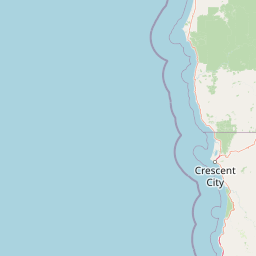
Map view of Kalmiopsis Wilderness

Use this park location map to pinpoint Kalmiopsis Wilderness in United States of America, understand its exact geographic position, and read its mapped placement within the surrounding landscape more clearly.

Pigeon | © OpenStreetMap contributors

Location context for Kalmiopsis Wilderness

Oregon
Recorded earthquake history

Examine the Historical Record of Earthquakes near the Kalmiopsis Wilderness

Access the comprehensive collection of documented seismic activity surrounding the Kalmiopsis Wilderness. Review event dates, magnitude statistics, and epicentre data within this structured database to understand the history of regional geological disturbances recorded near these protected mountain lands.

Kalmiopsis Wilderness Earthquake History

Catalogued events

18 events

Strongest magnitude

Magnitude 4.5

Most recent event

Jan 27, 2026

This history includes earthquakes recorded inside the park or within 50 km of its borders

Explore protected area photography, rugged canyon scenery, and rare botanical habitats.

Kalmiopsis Wilderness Photos and Landscapes: Visualizing the Klamath Mountain Terrain

Visual documentation captures the dramatic canyons, serpentine ridges, and wild river basins that define the rugged topography of Kalmiopsis Wilderness. Examining field photography reveals the complex plant communities, geologic formations, and post-fire recovery zones characteristic of this protected landscape.

A close up view of several small pink Kalmiopsis leachiana flowers against a soft, out of focus blue background.

A large, weathered boulder rests on a sparse, light-colored rocky slope in front of a dense coniferous forest under a clear sky.

A mountainous landscape covered in dense green coniferous forest under a clear blue sky, with visible ridgelines and slopes.

Park atlas

Compare surrounding Klamath Mountain terrain and connected protected landscapes

Parks Near Kalmiopsis Wilderness and Related Protected Areas in Southwest Oregon

Browsing other protected areas near Kalmiopsis Wilderness reveals a broader network of rugged Klamath Mountain terrain and diverse botanical landscapes. Comparing these neighboring wilderness tracts provides essential regional context for the unique geology and river headwaters of southwestern Oregon.
An artistic watercolor illustration showing a line of green evergreen trees in the foreground with hazy, distant mountains in the background against a light, neutral sky.
Protected landscapeOregon
Park boundaries overlap#1 closest

South

Rogue River, Siskiyou National Forest: Mapped Geography and Protected Area Overview

Tracing volcanic peaks and river-carved mountain terrain in Oregon

Spanning nearly 7,300 square kilometers, the Rogue River, Siskiyou National Forest acts as a crucial ecological anchor in the Pacific Northwest. This overview details its unique mountain geography, the extensive wilderness tracts within its boundaries, and the river systems that define its mountainous character.

Area
6,973.46 km²
Established
2004
Visitors
915K annual
Relief
Mountain
Watercolor painting of a peaceful river landscape, featuring rolling green hills, dense trees, and distant soft-toned mountains.
Protected areaCalifornia
3.4 km away#2 closest

South

Six Rivers National Forest: Exploring Protected River Valleys and Mountain Terrain in California

A regional protected area spanning California river systems

Six Rivers National Forest defines much of the rugged landscape in northwestern California. Named for the six major river drainages within its borders, the area features a unique combination of coastal forests, deep river canyons, and high-country ridges that offer significant insight into the region's broader geographic and ecological character.

Area
3,875.2 km²
Established
1947
Relief
Mountain
Climate
Mediterranean
A horizontal watercolor illustration showing a winding river flowing through a lush green valley with rolling hills in the background.
Protected landscapeCalifornia
3.4 km away#3 closest

South

Smith River National Recreation Area: Mapping the Klamath Mountain Protected Landscape

Watershed geography and rugged mountain terrain in northwestern California

Located in the heart of the Klamath Mountains, Smith River National Recreation Area represents a critical protected watershed in northern California. The area is defined by its deep, forested canyons and the clean, wild waters of the Smith River, which serve as a primary link between coastal redwood ecosystems and mountainous inland terrain. Users can study the park boundaries and regional landscape characteristics that sustain this remote environment.

Area
1,235 km²
Established
1990
Relief
Mountain
Climate
Mediterranean
National parkCalifornia
24 km away#4 closest

South

Redwood National and State Parks: Protected Landscape Geography and Mapped Boundaries

Explore California's protected area atlas.

Gain a structured understanding of Redwood National and State Parks as a protected national park within the geographic context of California. This dedicated page focuses on its mapped boundaries and protected landscape identity, offering critical atlas-level insights for regional geography exploration and conservation land context. Discover how this protected area fits into the larger mapped terrain.

Area
562.88 km²
Established
1968
IUCN
V
Visitors
458.4K annual
Wildlife reserveCalifornia
35 km away#5 closest

Southeast

Red Buttes Wilderness: Mapping the Protected Mountain Geography of the Siskiyou Range

A rugged wilderness reserve straddling California and Oregon

Red Buttes Wilderness preserves a complex mountainous terrain shaped by ancient metamorphic rocks and glacial history. The area features high ridgelines, alpine lakes, and specialized botanical habitats, providing a vital window into the ecological and geological diversity of the broader Klamath and Siskiyou mountain landscapes.

Area
80.7 km²
Established
1984
IUCN
Ib
Relief
Mountain
Protected landscapeCalifornia
66 km away#6 closest

Southeast

Marble Mountain Wilderness: Exploring Protected Mountain Landscapes in Northern California

Klamath Mountains Wilderness and Alpine Geography

Spanning hundreds of thousands of acres, Marble Mountain Wilderness offers a dense concentration of subalpine fir, deep glacial lakes, and steep drainage basins. This northern California protected landscape provides an atlas of rugged ridges and marble-toned peaks that represent one of the most ecologically diverse backcountry areas in the region.

Area
978.3 km²
Established
1964
IUCN
Ib
Relief
Mountain
A watercolor painting of soft, layered mountain ridges and forests in muted green, yellow, and red tones, presented in a wide, horizontal format against a white background.
Protected landscapeCalifornia
About 79 km away#7 closest

Southeast

Klamath National Forest; Protected Landscape Geography and Mapped Wilderness Boundaries

Diverse mountain terrain in Northern California

Klamath National Forest represents a significant protected area in Northern California, encompassing a vast, rugged landscape that bridges the Klamath Mountains and the Cascade Range. Its terrain is characterized by deeply incised river valleys, exposed rocky summits, and an intricate mosaic of coniferous forests. This geographic detail provides essential context on the forest's role as a major site for wilderness protection and ecological study in the Pacific Northwest.

Area
7,033 km²
Established
1905
Relief
Mountain
Climate
Temperate
A soft watercolor painting depicting a serene landscape with gentle green hills, a small forest, and a calm lake at sunrise or sunset.
Protected landscapeCalifornia
105 km away#8 closest

Southeast

Shasta, Trinity National Forest: Mapping the Protected Landscapes of Northern California

Volcanic peaks, expansive reservoirs, and rugged mountain wilderness

Spanning over two million acres, Shasta, Trinity National Forest represents a major protected landscape in Northern California. The geography includes the iconic Mount Shasta volcano and the complex shoreline of Shasta Lake, while hosting expansive wilderness areas and diverse terrain ranging from oak-forested foothills to alpine meadows.

Area
8,942.87 km²
Established
1954
Relief
Mountain
Climate
Temperate

Common questions about visiting, size, designation, and location context for Kalmiopsis Wilderness

Kalmiopsis Wilderness FAQs for park facts, access, geography, and protected area context

Find quick answers about Kalmiopsis Wilderness, including protected-area facts, park geography, trail and visitor context, and how the park fits into its surrounding country and regional landscape.
MoriAtlas Explorer

Continue Your Protected Areas Search Across the Global Atlas

Deepen your exploration by continuing the structured search for national parks and protected areas worldwide. Utilize the comprehensive filtering capabilities to compare different conservation landscapes and refine your understanding of global park geography. Discover more about the distribution and characteristics of protected natural areas.

Global natural geography