
Mori Atlas logo
Protected areaKavo Gkreko

Examining the intersection of limestone cliffs, marine habitats, and Mediterranean coastal biodiversity.

Kavo Gkreko: A Comprehensive Geographic Atlas of a Protected Coastal Landscape in Famagusta, Cyprus

Kavo Gkreko sits at the southeastern tip of Cyprus, representing a significant ecological microcosm within the Famagusta region. This protected area compresses diverse Mediterranean habitats, including limestone cliffs, sea caves, and extensive Posidonia seagrass meadows, into a singular coastal promontory. The atlas data highlights the intricate boundary between terrestrial phrygana scrub and submerged reef formations, providing a clear map-based perspective on one of the most ecologically rich sections of the eastern Mediterranean coastline.

Mediterranean coastlimestone cliffsPosidonia seagrassmarine habitatjuniper matorralphrygana
Digital vector-style illustration of high coastal cliffs dropping into a turquoise sea, with green Mediterranean vegetation in the foreground and a soft sunlit sky.

Kavo Gkreko

Protected area

Park overview

Structured park overview, official facts, and landscape profile for Kavo Gkreko

Kavo Gkreko park facts, protected area profile, and essential visitor context

Review the core facts for Kavo Gkreko, including designation, size, terrain, visitor scale, habitats, and operating context in one park-focused overview.

About Kavo Gkreko

Kavo Gkreko occupies the southeastern corner of Cyprus, a stretch of land that is often considered the most scenically dramatic section of the island's coastline. The cape itself is a low limestone headland exposed to the open Mediterranean, where wave-cut platforms, vertical cliffs, sea caves, and arches define the shore. Inland from the cliffs, the landscape transitions into a mosaic of garrigue, phrygana, juniper-dominated matorral, and patches of fragmented forest.

The site's ecological importance is rooted in its geographic position. Cyprus sits at a biogeographic crossroads between Europe, Asia, and Africa, and the southeastern cape in particular receives a strong marine influence from the southeastern Mediterranean basin. The combination of rocky shoreline, warm and relatively clear waters, and varied seabed has produced an unusually diverse assemblage of marine habitat types, including well-developed Posidonia seagrass meadows that are considered priority habitats under EU nature law.

Beyond the marine element, the terrestrial portion of Kavo Gkreko reflects classic eastern Mediterranean climatic conditions: long dry summers, mild winters, strong sunlight, and persistent winds. These conditions shape the vegetation into low, hardy formations dominated by sclerophyllous shrubs, aromatic herbs, and scattered juniper trees. The site also includes small temporary pools that fill in winter and spring, supporting specially adapted Mediterranean flora.

Because the site sits within the Natura 2000 framework, Kavo Gkreko is not only a locally important landscape but also a component of Europe's wider network of protected natural areas. Its combination of marine and terrestrial priority habitats, together with its listed species, has made it one of the more closely monitored Natura 2000 sites in Cyprus, and it serves as a useful reference for the state of Mediterranean coastal ecosystems in the southeastern part of the island.

Quick facts and research context for Kavo Gkreko

Kavo Gkreko is located in the Famagusta district of the Republic of Cyprus, at the southeasternmost point of the island. It covers approximately 18.8 hectares of land along with adjacent marine waters. The site was formally designated in 2004 and is registered in the Natura 2000 network as site CY3000005.

The site holds the distinction of being the easternmost Natura 2000 area in the European network. It functions simultaneously as an FFH (Fauna-Flora-Habitat) site and, largely overlapping, as the SPA (Special Protection Area) Kavo Gkreko for birdlife. Its habitats range from submerged marine features such as Posidonia seagrass meadows and reefs to terrestrial Mediterranean formations including juniper and Ziziphus matorral, phrygana, and dry grassland.

Protection and recognition

Review documented protection status, management scope, and Natura 2000 recognition for Kavo Gkreko.

Kavo Gkreko Protection Status and International Recognition Framework

Examine the mixed protection scope and international recognition records established for Kavo Gkreko. Review documented Natura 2000 designations and administrative details mapped across the protected area.

International recognition

Protection details

Protection scope
Mixed
Transboundary protection
No
WDPA ID
555579959
Park context

Deeper park guide and search-rich context for Kavo Gkreko

Kavo Gkreko history, landscape, wildlife, and travel context

Explore Kavo Gkreko through its history, landscape character, ecosystems, wildlife, conservation priorities, cultural context, and seasonal travel timing in a structured park guide built for atlas discovery and search intent.

Why Kavo Gkreko stands out

Kavo Gkreko is best known for its concentration of Mediterranean coastal and marine habitat types within a compact area. Posidonia oceanica seagrass meadows and reef habitats dominate the marine portion, while the terrestrial zone features some of the most characteristic vegetation formations of the eastern Mediterranean: juniper matorral, Sarcopoterium phrygana, halo-nitrophilous scrub, and fragments of ancient olive and carob forest. The area is also recognized for hosting protected species such as the Mediterranean monk seal and the common bottlenose dolphin in adjacent waters, alongside bat species like the lesser mouse-eared bat on land. Its combination of sea caves, limestone cliffs, submerged reefs, and dry Mediterranean scrub in one place gives Kavo Gkreko a strong identity as a microcosm of southeastern Mediterranean coastal ecology.
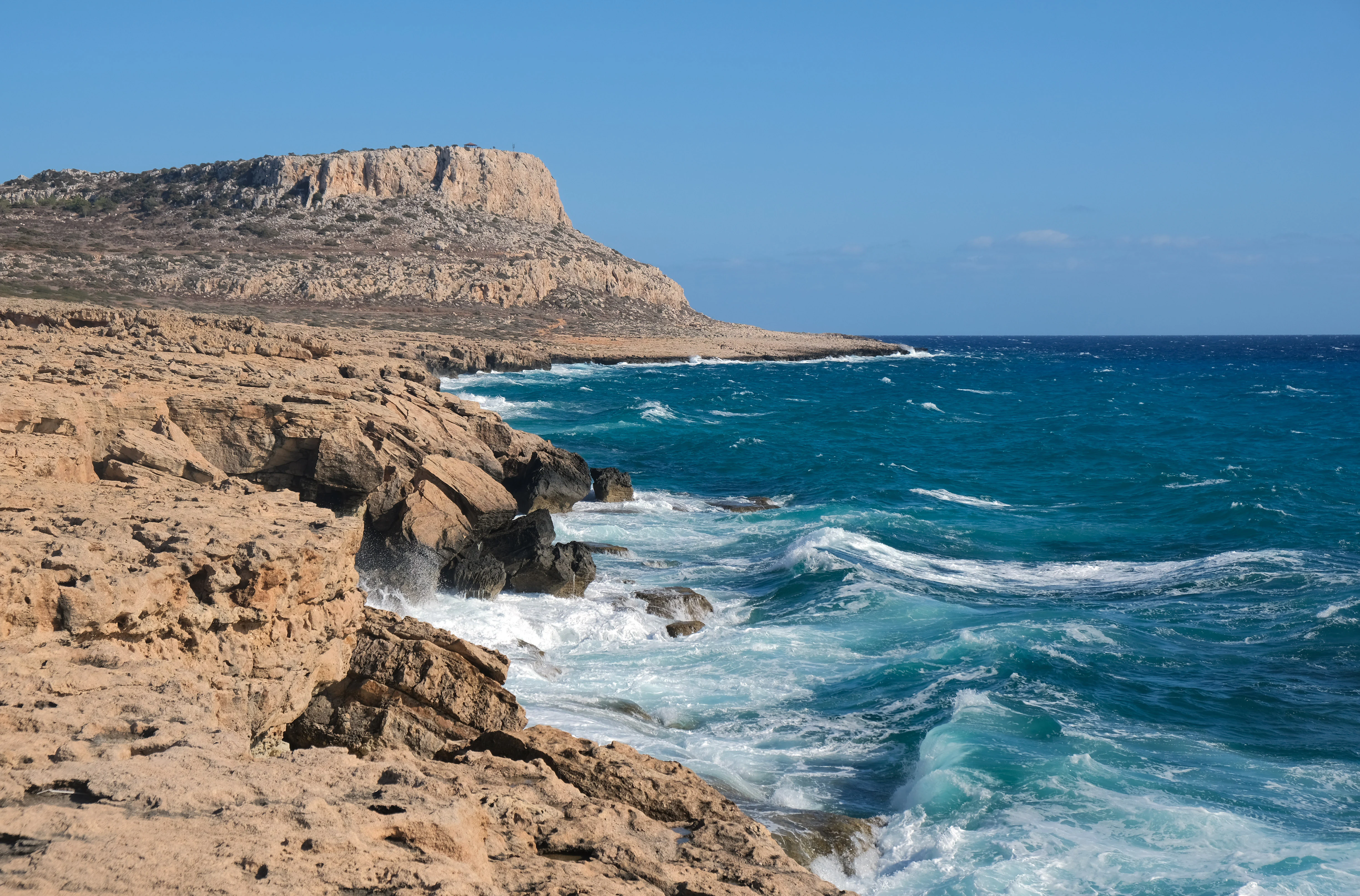
A wide coastal landscape showing jagged, light brown rocky cliffs meeting the deep blue Mediterranean Sea with white waves crashing against the base.
The rugged coastline of Cape Greco with its distinctive limestone cliffs overlooking the Mediterranean Sea.

Kavo Gkreko history and protected-area timeline

Kavo Gkreko entered the European conservation framework in 2004, when it was formally designated as a Fauna-Flora-Habitat site under the EU Habitats Directive and registered within the Natura 2000 network. Its designation reflected the recognition that the cape and its surrounding waters contained a meaningful concentration of Mediterranean habitat types and species of community interest.

Shortly after its designation, the overlapping SPA Kavo Gkreko was established to provide additional protection for birdlife using the area for breeding, wintering, or migration. Together, the two designations created a layered protection status that combines biodiversity conservation under the Habitats Directive with bird protection under the Birds Directive.

While the formal Natura 2000 designation is relatively recent, the landscape itself has a much longer history of informal human use. The rocky terrain and thin soils have limited intensive agriculture, which has helped preserve native vegetation cover in many parts of the cape. This historical land-use pattern, combined with the steep coastal cliffs and relatively inaccessible interior sections, has contributed to the survival of habitat types that have declined elsewhere in the Mediterranean.

Kavo Gkreko landscape and geographic character

The landscape of Kavo Gkreko is defined by the meeting of land and sea at the southeastern tip of Cyprus. The cape is built from limestone that has been shaped by long exposure to wind, salt spray, and wave action, producing an irregular shoreline of cliffs, small bays, arches, and sea caves. Inland, the topography remains relatively low and undulating, with rocky slopes descending toward the coast and pockets of flatter terrain in sheltered positions.

Vegetation cover across the landscape is sparse by northern European standards but richly textured in Mediterranean terms. Low, drought-adapted shrubs such as Sarcopoterium spinosum dominate the driest slopes, forming characteristic phrygana. In other sections, taller juniper formations give the land a more forested appearance, though trees remain widely spaced and small. On the most exposed coastal rocks, specialized Limonium species and sea-cliff plants cling to crevices.

The marine landscape is equally distinctive. Submerged continuation of the limestone geology appears as reefs and rocky ridges beneath shallow water, while flatter seabed areas support extensive Posidonia oceanica seagrass meadows. Caves and overhangs along the shore continue below the waterline, creating semi-submerged marine cave systems that are themselves recognized as a protected habitat type.

Kavo Gkreko ecosystems, habitats, and plant life

Ecologically, Kavo Gkreko represents a working example of southeastern Mediterranean coastal biodiversity compressed into a small area. The marine habitats form the most ecologically productive component of the site. Posidonia oceanica seagrass meadows are particularly significant because they stabilize the seabed, oxygenate the water column, and serve as nurseries for numerous fish and invertebrate species. Reef formations and submerged rocky habitats complement these meadows, creating structural diversity that supports a wide range of marine life.

On land, the terrestrial habitats follow a typical eastern Mediterranean successional and climatic pattern. The juniper-dominated matorral is among the most widespread, forming dense, evergreen thickets of small trees and shrubs that provide shelter and food for birds, reptiles, and insects. Smaller patches of Ziziphus matorral, halo-nitrophilous scrub, and dry Mediterranean grassland add further variety, as do small temporary freshwater pools that fill during the wet season and harbor specially adapted plant species.

Kavo Gkreko wildlife and species highlights

The wildlife profile of Kavo Gkreko blends marine and terrestrial species typical of the southeastern Mediterranean. In the surrounding waters, two mammals of high conservation interest are recorded: the Mediterranean monk seal, one of the most endangered marine mammals in the world, and the common bottlenose dolphin, which uses the area for movement and foraging. Both species underscore the importance of undisturbed coastline and sea cave habitat.

On land, bats are represented by species such as the lesser mouse-eared bat, which uses caves and rocky overhangs around the cape for roosting. The combination of cliffs, scrub, and seasonal pools supports a rich assemblage of reptiles, insects, and smaller mammals typical of eastern Mediterranean dryland environments. Birdlife is also a significant component, which is why the overlapping SPA Kavo Gkreko was designated, with raptors, seabirds, and migratory species using the area throughout the year.

Kavo Gkreko conservation status and protection priorities

Kavo Gkreko's principal conservation significance lies in its formal integration into the European Natura 2000 network. The site's dual status as a Fauna-Flora-Habitat area and an overlapping Special Protection Area means it is protected both for its habitats and species of community interest and for its birdlife. This layered designation provides one of the more robust protection frameworks available under EU nature law.

The site contains multiple priority habitats, including Posidonia seagrass meadows, Mediterranean temporary pools, and Mediterranean dry grasslands, all of which are considered threatened at the European scale. Their presence within a single small area elevates the conservation value of the site beyond what its modest size alone would suggest.

Kavo Gkreko also serves as an important refuge for species of community interest such as the Mediterranean monk seal and the bottlenose dolphin. Because both species depend on relatively undisturbed coastline and water quality, the site's protected status contributes directly to their long-term survival in Cypriot waters.

Kavo Gkreko cultural meaning and human context

The southeastern tip of Cyprus has long been part of the cultural geography of the island, with the dramatic cape forming a natural landmark visible from a considerable distance along the coast. Place names such as Kavo Gkreko, Kap Greco, and Cape Greco reflect the layered linguistic history of the island, incorporating Greek, Italian-influenced, and English designations.

In local tradition, the headland is associated with myths and stories tied to the sea, including legends linking it to figures from the ancient Mediterranean world. While these associations are informal, they contribute to the cultural weight of the landscape and reinforce its identity as one of the more recognizable natural landmarks on the island.

Top sights and standout views in Kavo Gkreko

Kavo Gkreko's strongest highlights are ecological rather than infrastructural: the compact presence of Posidonia seagrass meadows together with terrestrial Mediterranean habitats, the visibility of sea caves and cliff formations along the cape, and the layered protection that the site enjoys through both the Habitats Directive and the Birds Directive.

For visitors interested in natural heritage, the area offers a clear window into southeastern Mediterranean coastal ecology, with juniper matorral, phrygana, coastal cliffs, and underwater meadows all encountered within a small geographic footprint. The site's easternmost position within the Natura 2000 network also gives it a symbolic significance as a boundary marker of European nature protection in the Mediterranean.

Best time to visit Kavo Gkreko

The character of a visit to Kavo Gkreko shifts meaningfully with the seasons. Spring is generally the most rewarding period, when temperatures are mild, the terrestrial vegetation is in bloom, and the temporary freshwater pools that are part of the site's protected habitat network are filled. This is also a strong season for observing birdlife and general biodiversity on land.

Summer brings hotter, drier conditions, with reduced vegetation cover and more intense coastal activity. The sea is at its calmest and warmest, making it a more attractive season for marine-focused visits, though the land can feel stark. Autumn and winter are cooler and quieter, with softer light, occasional rainfall, and increasing bird activity, especially during migration periods.
Monthly climate preview

Track long-term temperature patterns and monthly precipitation cycles across Kavo Gkreko.

Kavo Gkreko Climate Normals, Average Temperature and Monthly Precipitation Records

Historical climate data for Kavo Gkreko reveals measured long-term averages spanning monthly temperature variations and precipitation rates recorded between 1991 and 2020. Detailed monthly normals provide comprehensive meteorological context for studying annual weather cycles across the protected area.
Annual mean21 °C
15 °C28 °C
Jan15°
Feb15°
Mar16°
Apr18°
May21°
Jun25°
Jul27°
Aug28°
Sep27°
Oct25°
Nov21°
Dec17°
Warmest month
August

28.1 °C

Coolest month
February

15.1 °C

Wettest month
December

3 mm/day

Driest month
July

0.1 mm/day

Park location guide

Geography guide, regional context, and park location map for Kavo Gkreko

Kavo Gkreko park geography, regions, and map view in Cyprus

Understand where Kavo Gkreko sits in Cyprus through a broader geographic reading of the surrounding landscape, nearby location context, and its mapped position within the national park landscape.

How Kavo Gkreko fits into Cyprus

Cyprus is an island nation in the eastern Mediterranean Sea, positioned at the crossroads of Europe, Africa, and Asia. The Republic of Cyprus governs the southern portion of the island, with Nicosia as its capital and largest city. The island has a complex political situation due to the Turkish occupation in the north and contains British military bases in the south. Cyprus gained independence from Britain in 1960 and is a member of the European Union.

Wider geography shaping Kavo Gkreko in Cyprus

Cyprus is an island located in the eastern Mediterranean Sea, off the coast of the Levant in West Asia. The island lies approximately 75 km south of Turkey, 105 km west of Syria, and 380 km north of Egypt. The terrain varies from mountainous regions in the north and interior to plains and coastal areas. The Troodos Mountains dominate the central and southwestern part of the island. The island has no land borders as it is entirely surrounded by sea.

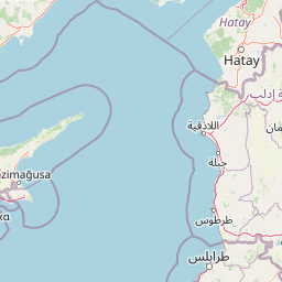
Map view of Kavo Gkreko

Use this park location map to pinpoint Kavo Gkreko in Cyprus, understand its exact geographic position, and read its mapped placement within the surrounding landscape more clearly.

Pigeon | © OpenStreetMap contributors

Location context for Kavo Gkreko

Famagusta
Recorded earthquake history

View the Historical Earthquake Records and Seismic Data for Kavo Gkreko

Examine the historical catalogue of seismic events recorded in the vicinity of Kavo Gkreko. MoriAtlas provides a clear, data-focused look at earthquake occurrences near this protected Mediterranean promontory for researchers and geography enthusiasts.

Kavo Gkreko Earthquake History

Catalogued events

96 events

Strongest magnitude

Magnitude 5.4

Most recent event

Jun 23, 2025

This history includes earthquakes recorded inside the park or within 50 km of its borders

Explore photographic records of limestone cliffs, sea caves, and protected marine environments

Kavo Gkreko Photos and Landscape Scenery: Visualizing Mediterranean Coastal Habitats

Visual documentation reveals the rugged terrain, coastal cliffs, and diverse habitats defining Kavo Gkreko across its protected coastal zone. Examining these photographs helps researchers and observers understand the unique ecological character of the cape and its surrounding marine ecosystems.

A wide coastal landscape showing jagged, light brown rocky cliffs meeting the deep blue Mediterranean Sea with white waves crashing against the base.

Park atlas

Compare adjacent marine reserves and regional protected habitats across the eastern coast

Explore Parks Near Kavo Gkreko and Surrounding Protected Coastal Landscapes

Browsing other protected areas near Kavo Gkreko reveals connected Mediterranean habitats, limestone cliffs, and marine ecosystems. Extending the geographic comparison helps trace regional conservation networks and coastal biodiversity patterns beyond a single promontory.
Protected areaCyprus
5.5 km away#1 closest

West

Periochi Agias Theklas - Liopetri: Protected Coastal Geography and Bird Habitat

Natura 2000 protected area in the Famagusta Bay region

Periochi Agias Theklas - Liopetri is a compact coastal site in southeastern Cyprus known for its bird-focused conservation efforts. Within its boundaries, the landscape features low-lying Mediterranean scrub, open ground, and agricultural edges that provide refuge for waders, herons, and migratory species. This site plays an essential role in maintaining ecological connectivity within the Mediterranean flyway.

Area
0.698 km²
Established
2008
Relief
Lowland
Scope
Terrestrial
Wildlife reserveCyprus
About 8 km away#2 closest

Northwest

Deryneia (Vogelschutzgebiet) Wildlife Reserve: Protected Coastal Geography in Cyprus

Coastal phrygana shrubland and migratory bird habitat.

Deryneia (Vogelschutzgebiet) is a unique coastal protected area in Cyprus, defined by its small size and strategic position within the UN buffer zone. This wildlife reserve features steep terrain and phrygana vegetation, creating a vital, low-disturbance stopover for migratory birds traversing the Mediterranean flyway. Gain a structured understanding of its mapped boundaries and physical landscape through the MoriAtlas database.

Area
0.057 km²
Established
2021
Relief
Lowland
Scope
Terrestrial
Protected areaCyprus
About 11 km away#3 closest

West

Ethniko Dasiko Parko Potamos Liopetriou: Coastal Wetland and Protected Landscape Atlas

A diverse protected area on the southeastern Cypriot coastline.

Spanning the mouth of the Liopetri River, this protected area features a layered terrain of salt-influenced soils, dune belts, and phrygana scrubland. It is defined by the integration of seasonal ponds and Mediterranean cliff vegetation, offering a rare look at the natural ecological transitions along the developed coast of Cyprus.

Area
0.747 km²
Established
2009
Relief
Lowland
Climate
Mediterranean
Nature reserveCyprus
34 km away#4 closest

West

Periochi Kosiis - Pallourokampou Nature Reserve: Regional Geography and Protected Boundaries

Inland Cyprus protected landscape and natural terrain mapping

Periochi Kosiis - Pallourokampou represents a crucial nature reserve within the Mediterranean ecoregion of Cyprus. Examine the park boundaries and regional geographic context through this structured atlas entry, which details the terrestrial landscape features defining this inland conservation area.

Area
37.178 km²
Established
2007
Climate
Mediterranean
Scope
Terrestrial
A horizontal watercolor illustration of a wetland scene with a calm body of water, grassy shorelines, and distant rolling hills under a soft sky.
Nature reserveLarnaca District
36 km away#5 closest

West

Alykes Larnakas Nature Reserve: Atlas of Protected Wetlands and Coastal Mediterranean Terrain

Ecological landscape mapping in the Larnaca District of Cyprus

Alykes Larnakas functions as a cohesive wetland landscape featuring the expansive Larnaka Salt Lake alongside smaller basins like Orfani and Soros. The reserve protects a gradient of ecosystems ranging from coastal lagoons and salt-crust basins to Mediterranean phrygana and dry grassland textures that define the southeastern coast of Cyprus.

Area
15.602 km²
Established
2008
Protected areaCyprus
40 km away#6 closest

West

Ethniko Dasiko Parko Rizoelias: A Natura 2000 Protected Area and Mediterranean Habitat Mosaic

Ecological geography and landscape context in inland Cyprus

Ethniko Dasiko Parko Rizoelias represents a significant conservation effort in Cyprus, balancing rare gypsophilous vegetation with Mediterranean shrubland. Its triple Natura 2000 status protects 34 bird species and reptile communities within a compact, structurally diverse terrestrial environment.

Area
1.238 km²
Established
2004
Relief
Lowland
Climate
Mediterranean
Protected areaTajikistan
About 45 km away#7 closest

West

Periochi Moytti Toy Ziou: Protected Landscape and Geographic Overview in Tajikistan

Mapped boundaries and regional protected area context

Discover the geographic identity of Periochi Moytti Toy Ziou, a key protected area situated in Tajikistan. This entry provides essential mapping and landscape data to help visualize the park's boundaries, surrounding terrain, and its contribution to regional conservation geography.

Area
0.181 km²
Relief
Lowland
Scope
Terrestrial
Water
Minor water
Nature reserveCyprus
47 km away#8 closest

West

Periochi Lympion - Agias Annas: Inland Protected Landscapes and Nature Reserve Atlas

Mediterranean shrubland and bird conservation zones in central Cyprus

Periochi Lympion - Agias Annas preserves essential thermo-Mediterranean shrubland and Sarcopoterium-dominated phrygana formations within the Cyprus interior. This protected landscape sustains a mosaic of pseudo-steppe grasslands and diverse bird populations, providing a focused view of inland habitat conservation within the eastern Mediterranean ecoregion.

Area
5.167 km²
Established
2002
Relief
Lowland
Scope
Terrestrial

Common questions about visiting, size, designation, and location context for Kavo Gkreko

Kavo Gkreko FAQs for park facts, access, geography, and protected area context

Find quick answers about Kavo Gkreko, including protected-area facts, park geography, trail and visitor context, and how the park fits into its surrounding country and regional landscape.
MoriAtlas Explorer

Continue Your Protected Areas Search Across the Global Atlas

Deepen your exploration by continuing the structured search for national parks and protected areas worldwide. Utilize the comprehensive filtering capabilities to compare different conservation landscapes and refine your understanding of global park geography. Discover more about the distribution and characteristics of protected natural areas.

Global natural geography