

Mori Atlas logo
Protected areaKimmelkær Landkanal

A vital canal habitat and aquatic refugium located within the regional terrain of Midtjylland.

Kimmelkær Landkanal Protected Area: Geographic Context and Landscape Analysis in Denmark

(Natura 2000 area no. 71 Kimmelkær Landkanal)

Kimmelkær Landkanal represents a highly focused protected area in Region Midtjylland, centering on a 2.7 kilometer canal corridor. This site is defined by its sandy bed and its critical role as a refugium for rare aquatic plant populations, maintaining a unique hydrological link to the broader wetland systems of Tim Engsø and Stadil Fjord. The surrounding landscape reflects the subtle topography of a former marine foreland, creating an essential ecological micro-environment.

Natura 2000habitat areacanal habitatfreshwater ecosystemaquatic plant conservationrare species protection

Kimmelkær Landkanal

Protected area

Park overview

Structured park overview, official facts, and landscape profile for Kimmelkær Landkanal

Kimmelkær Landkanal park facts, protected area profile, and essential visitor context

Review the core facts for Kimmelkær Landkanal, including designation, size, terrain, visitor scale, habitats, and operating context in one park-focused overview.

About Kimmelkær Landkanal

Kimmelkær Landkanal is one of Denmark's smallest internationally recognized nature protection areas, yet it carries ecological weight far beyond its modest size. Designated as Natura 2000 habitat area H178, the site covers just about 3 hectares centered on a 2.7 kilometer stretch of an old canal in the Central Jutland Region, within Ringkøbing-Skjern Kommune. Its setting lies in a former marine foreland, giving the broader landscape a low-lying, water-influenced character shaped by long-term interaction between land and fjord systems.

The canal itself follows a soft, sandy bed and runs parallel to the small watercourse known as Star Grøft. Its waters eventually discharge into Tim Engsø and Tim Å, joining broader hydrological pathways that lead to the northern end of Stadil Fjord. This connection to larger wetland and fjord systems means that what happens in the canal can influence downstream ecological conditions, while also tying the site into the wider Ringkøbing Fjord water planning district.

The defining reason for the site's protected status is the presence of vandranke, a sensitive aquatic plant species for which Denmark holds national responsibility. The species is classed as acutely threatened on the Danish Red List and is listed under both Annex II and Annex IV of the EU Habitats Directive, requiring active conservation measures. Kimmelkær Landkanal supports one of the few large and stable Danish populations of this plant, and observations between 2004 and 2008 indicated an increase in population size in the lower canal section, suggesting that the habitat conditions there are favorable for the species.

Management of the area follows the Natura 2000 framework adopted in Denmark in 2011, with municipal authorities and the Danish Nature Agency coordinating binding action plans. The natural area plan for Kimmelkær Landkanal is harmonized with the water management plan for the main watercourse district of Ringkøbing Fjord, recognizing the canal as part of an integrated catchment rather than an isolated habitat fragment. Despite its minute footprint, the site stands out as a focused, high-value refuge for a single highly protected aquatic species within a broader agricultural and fjord landscape.

Quick facts and research context for Kimmelkær Landkanal

Kimmelkær Landkanal is a Natura 2000 habitat area (site code H178) in the Central Jutland Region of Denmark, administered under Ringkøbing-Skjern Kommune. The protected area covers about 3 hectares along roughly 2.7 kilometers of an old canal.

The site is designated primarily for the protection of the aquatic plant vandranke, listed as acutely threatened on the Danish Red List and protected under the EU Habitats Directive. Habitat plans for the area were adopted in 2011 and are coordinated with water management plans for the Ringkøbing Fjord catchment.

Protection and recognition

Documented terrestrial protection scope, designation history, and Natura 2000 records

Kimmelkær Landkanal Protection Status and International Recognition Data

Terrestrial protection status records for Kimmelkær Landkanal detail the 2011 designation history and official Natura 2000 recognition sources. Structured protection parameters outline the documented conservation scope and administrative framework associated with the protected landscape.

International recognition

Protection details

Protection scope
Terrestrial
Designated year
2011
Park context

Deeper park guide and search-rich context for Kimmelkær Landkanal

Kimmelkær Landkanal history, landscape, wildlife, and travel context

Explore Kimmelkær Landkanal through its history, landscape character, ecosystems, wildlife, conservation priorities, cultural context, and seasonal travel timing in a structured park guide built for atlas discovery and search intent.

Why Kimmelkær Landkanal stands out

Kimmelkær Landkanal is best known for sheltering one of Denmark's few large and stable populations of the rare aquatic plant vandranke. For this single species, Denmark bears national responsibility, which is why the tiny canal corridor was elevated to Natura 2000 habitat status. Between 2004 and 2008, population surveys recorded growth in the size of the vandranke population in the lower section of the canal, underscoring the site's role as a refugium for the species in central Jutland.

Kimmelkær Landkanal history and protected-area timeline

Kimmelkær Landkanal originated as a practical hydraulic feature in the old marine foreland of central Jutland, where naturally low-lying land required managed drainage channels. Over time, the canal evolved from an agricultural drainage feature into an ecologically important freshwater corridor.

The turning point in its modern history came with the implementation of the EU Natura 2000 network in Denmark. Designation as habitat area H178 formalized the canal's status as a protected natural site. The Natura 2000 plan for the area was adopted in 2011, after which municipal councils and the Danish Nature Agency developed binding action plans to guide conservation management.

Between 2004 and 2008, monitoring documented an increase in the local population of vandranke in the lower section of the canal, reinforcing the case for continued protection. The natural area plan is coordinated with regional water planning under the Ringkøbing Fjord catchment, embedding the small canal site into broader hydrological and ecological management processes.

Kimmelkær Landkanal landscape and geographic character

The landscape of Kimmelkær Landkanal reflects the character of an old marine foreland in central Jutland, a low-relief environment where former seafloor and reclaimed coastal land transition gradually into managed inland terrain. Elevation is minimal, and much of the visual identity of the area is defined by water, channel edges, and subtle ground patterns rather than dramatic relief.

The canal itself is a narrow, slow-moving watercourse about 2.7 kilometers long within the Natura 2000 boundary. Its bed consists of soft sandy sediments, which influence both water flow and the plant communities that can establish along its margins. The canal runs roughly parallel to Star Grøft, a small neighboring watercourse, and the two together create a characteristic double-channel pattern within the former foreland.

Downstream, the canal drains into Tim Engsø and Tim Å, linking it via small lakes and streams to the northern end of Stadil Fjord. This hydrological chain connects the site to a much larger wetland and fjord landscape, even though the protected area itself occupies a remarkably small footprint.

Kimmelkær Landkanal ecosystems, habitats, and plant life

Ecologically, Kimmelkær Landkanal is defined by its freshwater canal habitat and its role in supporting aquatic plant biodiversity in a landscape dominated by former coastal land. The sandy bed and gentle flow conditions create a substrate well suited to submerged and floating aquatic vegetation.

The site's nature value is concentrated rather than broad: it has been formally designated to protect a single species of high national and European conservation concern, which in turn defines the entire ecological profile of the area. This focused character makes the canal an unusually narrowly targeted, but highly specialized, nature reserve within the Danish Natura 2000 network.

Kimmelkær Landkanal wildlife and species highlights

Kimmelkær Landkanal's wildlife profile is dominated not by fauna but by a single highly protected aquatic plant: vandranke. The site is one of the few places in Denmark where the species occurs in large and stable numbers, and this population forms the core reason for its Natura 2000 habitat designation.

Vandranke is listed as acutely threatened on the Danish Red List, and its presence at Kimmelkær Landkanal places the site on the front line of conservation responsibility for the species nationally. Monitoring between 2004 and 2008 showed an increase in population size in the lower section of the canal, indicating that habitat conditions there are suitable for sustaining or expanding the species.

Kimmelkær Landkanal conservation status and protection priorities

Kimmelkær Landkanal is protected primarily because it holds one of Denmark's few substantial populations of vandranke, a species for which Denmark bears national responsibility. The plant is classed as acutely threatened on the Danish Red List and is protected under both Annex II and Annex IV of the EU Habitats Directive, both of which require active conservation and monitoring efforts.

The site was formally incorporated into the Natura 2000 network as habitat area H178, and a Natura 2000 plan was adopted in 2011. Following adoption, the responsible municipal authorities and the Danish Nature Agency prepared binding action plans to manage habitat conditions for the protected species. The natural area plan is coordinated with the water management plan for the Ringkøbing Fjord watercourse district, recognizing that the canal's ecological value depends on maintaining clean, stable water conditions within the broader catchment.

Although the area is exceptionally small, at roughly 3 hectares and about 2.7 kilometers of canal length, its conservation importance is high because of its disproportionate role in safeguarding a single, highly threatened aquatic plant species.

Kimmelkær Landkanal cultural meaning and human context

Kimmelkær Landkanal reflects the long human management of low-lying former marine foreland in central Jutland, where drainage canals were created to make land usable. While the area has no prominent cultural landmarks, its very existence as a canal marks the broader agricultural and hydrological history of the region, where generations of drainage and water management have shaped today's landscape.

Top sights and standout views in Kimmelkær Landkanal

Kimmelkær Landkanal's standout feature is the combination of an exceptionally small protected footprint with an exceptionally high conservation responsibility: it shelters one of Denmark's few stable populations of the acutely threatened aquatic plant vandranke, a species under both Annex II and Annex IV of the EU Habitats Directive.

The canal's soft sandy bed, its parallel course with Star Grøft, and its hydrological connection to Tim Engsø, Tim Å, and Stadil Fjord give the small site an outsized role within the Ringkøbing Fjord water system. Population growth observed in the lower canal between 2004 and 2008 underscores its function as a living refugium for a fragile species.

Best time to visit Kimmelkær Landkanal

Source material does not provide detailed seasonal or visitor-oriented information about Kimmelkær Landkanal. Because it is a small, ecologically focused habitat site rather than a visitor-oriented park, broad seasonal guidance cannot be reliably constructed from the available information, and this field is intentionally limited.
Monthly climate preview

Long-term representative point measurements tracking monthly averages across Region Midtjylland

Kimmelkær Landkanal Climate Normals: Measured Annual Temperature and Precipitation Rhythms

Kimmelkær Landkanal exhibits measured long-term temperature variations from winter lows of negative 3.79 degrees Celsius to summer highs reaching 23.82 degrees Celsius alongside steady daily precipitation rates. Reviewing the complete twelve-month climatological profile provides a detailed breakdown of historical weather patterns recorded at a representative coordinate.
Annual mean9 °C
2 °C17 °C
Jan
Feb
Mar
Apr
May11°
Jun14°
Jul17°
Aug17°
Sep15°
Oct11°
Nov
Dec
Warmest month
August

17.2 °C

Coolest month
February

2.3 °C

Wettest month
October

3.3 mm/day

Driest month
April

1.5 mm/day

Park location guide

Geography guide, regional context, and park location map for Kimmelkær Landkanal

Kimmelkær Landkanal park geography, regions, and map view in Denmark

Understand where Kimmelkær Landkanal sits in Denmark through a broader geographic reading of the surrounding landscape, nearby location context, and its mapped position within the national park landscape.

How Kimmelkær Landkanal fits into Denmark

Denmark is a constitutional monarchy and Nordic country in Northern Europe. It is the southernmost of the Scandinavian countries, bordering Germany to the south, Norway to the north, and Sweden to the southwest. The country consists of the Jutland peninsula and an archipelago of islands, with Copenhagen as its capital and largest city. Denmark has a population of over 6 million and is characterized by flat, arable land, sandy coasts, and a temperate climate.

Wider geography shaping Kimmelkær Landkanal in Denmark

Denmark occupies the Jutland peninsula and roughly 406 islands in Northern Europe. It is situated between the North Sea to the west and the Baltic Sea to the east. The country borders Germany to the south and is connected to Sweden via the Øresund Bridge. Denmark is predominantly flat terrain with low elevation, the highest point being Møllehøj at 170.86 meters.

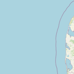
Map view of Kimmelkær Landkanal

Use this park location map to pinpoint Kimmelkær Landkanal in Denmark, understand its exact geographic position, and read its mapped placement within the surrounding landscape more clearly.

Pigeon | © OpenStreetMap contributors

Location context for Kimmelkær Landkanal

Region Midtjylland
Recorded earthquake history

Review the Historical Earthquake Catalogue for Kimmelkær Landkanal

Explore documented seismic activity associated with the location of Kimmelkær Landkanal. This MoriAtlas collection provides filtered historical records to support your study of regional seismic history around the protected canal habitat.

Kimmelkær Landkanal Earthquake History

Catalogued events

1 event

Strongest magnitude

Magnitude 3.8

Most recent event

Sep 16, 2018

This history includes earthquakes recorded inside the park or within 50 km of its borders

Park atlas

Discover related wetland habitats, freshwater ecosystems, and regional nature reserves

Exploring Parks Near Kimmelkær Landkanal and Protected Areas in Central Jutland

Compare Kimmelkær Landkanal with other protected natural areas across the surrounding central Jutland region. Broaden your geographic exploration by examining adjacent wetland ecosystems and linked river catchments.
Protected areaDenmark
About 2.5 km away#1 closest

Southwest

Natura 2000 area no. 66 Stadil Fjord og Vest Stadil Fjord Coastal Wetland Complex

Protected lagoon and dune landscape in western Jutland, Denmark.

Natura 2000 area no. 66 Stadil Fjord og Vest Stadil Fjord comprises a significant coastal lagoon system, encompassing shallow brackish waters, reed beds, and surrounding dune heaths. This protected area supports a high degree of botanical diversity and provides essential habitat for various bird species, serving as a primary example of Denmark's complex hydrological and coastal geography.

Area
69.03 km²
Relief
Lowland
Climate
Temperate
Access
Easy access
Nature reserveRegion Midtjylland
6.1 km away#2 closest

North

Husby Sø og Nørresø Nature Reserve: Protected Wetland Landscape in Region Midtjylland

Coastal plain geography and shallow lake habitat mapping

Situated in the coastal landscape of Region Midtjylland, Husby Sø og Nørresø represents a critical nature reserve defined by two interconnected shallow lakes. The protected area features extensive reedswamp margins, bog vegetation, and a human-modified marine foreland, hosting high aquatic plant diversity that remains central to the region's conservation identity.

Area
3.52 km²
Established
2011
Relief
Lowland
Climate
Temperate
A pale, minimalist watercolor painting showing a green grassy island in the middle of a calm, reflective lagoon under a soft pink and white sky.
Protected areaRegion Midtjylland
10 km away#3 closest

North

Nissum Fjord Protected Area: Geography and Coastal Wetland Map of Region Midtjylland

A diverse mosaic of dune systems, lagoon basins, and freshwater habitats

Nissum Fjord stands as a central protected wetland complex on the western Jutland coast. This area provides a comprehensive view of coastal geography, ranging from fixed dune heaths and sea-buckthorn scrub to the quiet, shallow waters of its three interconnected basins. Its protected boundaries include the island of Fjandø and significant inland lake systems, offering a distinct study in Denmark's coastal transitions and avian staging environments.

Area
109.67 km²
Established
2011
Relief
Lowland
Climate
Temperate
A pale watercolor landscape painting of a quiet fjord with soft green and pink marshy vegetation in the foreground and rolling hills in the background.
Protected areaRegion Midtjylland
12 km away#4 closest

South

Ringkøbing Fjord og Nymindestrømmen: Coastal Lagoon and Protected Wetland Geography

A vast Danish wetland complex in Region Midtjylland.

Ringkøbing Fjord og Nymindestrømmen defines the Danish west coast through its unique combination of brackish lagoons, salt meadows, and dune belts. This protected area integrates the Skjern Å river delta and the freshwater-lagoon chain of Nymindestrømmen, creating an internationally significant habitat for diverse waterbirds and migratory species across its multi-layered terrain.

Area
276.84 km²
Relief
Lowland
Climate
Temperate
Scope
Mixed
Nature reserveCentral Denmark Region
About 18 km away#5 closest

Northeast

Heder og klitter på Skovbjerg Bakkeø, Idom Å og Ormstrup Hede Nature Reserve Atlas and Map

Mapping glacial moraine and inland dune landscapes in the Central Denmark Region

The protected area surrounding Heder og klitter på Skovbjerg Bakkeø, Idom Å og Ormstrup Hede comprises extensive inland dunes and heathlands anchored by a Saalian moraine hill island. This site serves as a crucial ecological link, featuring restored riparian stream habitats and rare forest remnants that provide deep insight into Denmark’s post-glacial geological development.

Area
22.14 km²
Established
1985
Relief
Lowland
Scope
Terrestrial
Nature reserveRegion Midtjylland
About 33 km away#6 closest

Southeast

Natura 2000-område nr. 68 Skjern Å: Protected Riverine Geography and Valley Landscapes

A central Jutland nature reserve featuring glacial valley systems

Explore the geographic boundary and habitat diversity of Natura 2000-område nr. 68 Skjern Å. This protected landscape preserves the vital connection between freshwater river channels, raised bogs, and open heathland, serving as a landmark for regional river management and biodiversity conservation in western Denmark.

Area
25.8 km²
Established
2011
Nature reserveCentral Denmark Region
35 km away#7 closest

Southeast

Borris Hede Nature Reserve: Mapping the Protected Heathland of the Central Denmark Region

Glacial plains, wetland mosaics, and habitat conservation zones

Borris Hede encompasses a massive stretch of sandy outwash plain in central-western Denmark. This nature reserve serves as a vital habitat mosaic, ranging from dry and wet heath to bogs and riparian stream corridors. By preserving these open terrain characteristics, the site supports specialized birdlife and maintains one of the most distinctive geological and biological landscapes within the Danish geography.

Area
47.78 km²
Established
1903
Relief
Lowland
Climate
Temperate
Protected areaRegion Midtjylland
35 km away#8 closest

South

Lønborg Hede Protected Area: Heathland Geography and Mire Ecosystems in Denmark

Detailed landscape analysis of a unique Central Jutland nature reserve

Lønborg Hede is a distinctive protected area featuring a rare micro-topographic gradient where inland dune heath rises 15 meters above wet bog and mire environments. This site provides a concentrated look at western Jutland's historical heathland character, featuring a mosaic of nutrient-poor aquatic habitats and diverse ground-nesting bird environments across 350 hectares.

Area
3.53 km²
Established
1970
Relief
Lowland
Scope
Terrestrial

Common questions about visiting, size, designation, and location context for Kimmelkær Landkanal

Kimmelkær Landkanal FAQs for park facts, access, geography, and protected area context

Find quick answers about Kimmelkær Landkanal, including protected-area facts, park geography, trail and visitor context, and how the park fits into its surrounding country and regional landscape.
MoriAtlas Explorer

Continue Your Protected Areas Search Across the Global Atlas

Deepen your exploration by continuing the structured search for national parks and protected areas worldwide. Utilize the comprehensive filtering capabilities to compare different conservation landscapes and refine your understanding of global park geography. Discover more about the distribution and characteristics of protected natural areas.

Global natural geography
