
Mori Atlas logo
Nature reserveKipshagener Teiche

Mapping the ecological history of one of the oldest protected areas in the Senne region

Kipshagener Teiche Nature Reserve and Protected Wetland Landscape in North Rhine-Westphalia

(Naturschutzgebiet Kipshagener Teiche)

Kipshagener Teiche represents a compact, ecologically significant nature reserve spanning roughly eleven hectares within the sandy Senne lowlands. This protected landscape preserves a rare mosaic of transitional bog, wet heath, and alder swamp forest, serving as a critical reference site for wetland restoration in North Rhine-Westphalia. The area captures a complex history of environmental change and ongoing conservation efforts, providing a unique look at the regional struggle to maintain bog flora and dragonfly habitats in a modern German landscape.

Senne landscapenature reserveponds and wetlandtransitional bogwet heathalder swamp forest
A flat-style digital illustration featuring a calm pond reflecting the surrounding forest and distant rolling hills under a soft pastel sunset sky.

Kipshagener Teiche

Nature reserve

Park overview

Structured park overview, official facts, and landscape profile for Kipshagener Teiche

Kipshagener Teiche park facts, protected area profile, and essential visitor context

Review the core facts for Kipshagener Teiche, including designation, size, terrain, visitor scale, habitats, and operating context in one park-focused overview.

About Kipshagener Teiche

The Kipshagener Teiche occupies a modest but ecologically meaningful footprint in the Senne, a sandy lowland region in eastern North Rhine-Westphalia. Surrounded today by pine forests, agricultural fields, a high-voltage power line to the west, and nearby sports facilities along its southern edge, the reserve is an island of wetland and bog habitat in a landscape that has otherwise been heavily transformed by forestry, agriculture, and settlement. The area's two ponds, once part of a three-pond system visible on the 1837 Prussian original survey, give the site both its name and its defining hydrological character.

The site's long history of scientific study has shaped its identity as much as its ecology. Floristic investigations began in 1933, and the reserve was first placed under nature protection in 1937, making it one of the earliest formal reserves in the Senne. The 20th century brought serious ecological pressures: heath-peat complexes were buried under sand, ponds were treated with lime, sensitive moor depressions were destroyed, and from 1942 onward wastewater was discharged into the vicinity of the reserve, leading to eutrophication and the loss of once-rich floating and shoreline vegetation, including white water lilies. The current protected-area statute dates from 1970, when the legally protected area was actually reduced in extent before later conservation efforts restored focus on the site's most sensitive features.

Since the late 1980s, restoration and management have improved conditions in parts of the reserve. A dam was built to separate and protect a section of transitional bog from further eutrophication, and a pre-settlement basin with gravel banks was added in front of the upper pond to improve water quality. Sensitive zones were fenced off from visitors. These interventions reflect a broader recognition that the reserve holds some of the most botanically significant surviving wetland habitat in the Senne, even as many of its rarest species have disappeared over the past century. The Kipshagener Teiche today functions both as a refuge for specialized bog plants and dragonflies and as a long-term monitoring site for the ecological state of the Senne's wetland landscapes.

Quick facts and research context for Kipshagener Teiche

The Kipshagener Teiche is a nature reserve of about 11.25 hectares in North Rhine-Westphalia, Germany, administered by the Untere Landschaftsbehörde of the Kreis Gütersloh. It lies in the Senne landscape between Stukenbrock and Schloß Holte, roughly 600 metres west-southwest of the historic Kipshagen farm. The site was first protected in 1937 and is among the oldest nature reserves in the Senne, alongside the Langenbergteich, Ramselbruch, and Furlbachtal. A renewed protection regulation came into force in 1970, and significant restoration work was carried out from 1989 onward. Ecologically, the reserve combines ponds, transitional bog, wet heath, alder swamp forest, oak-birch remnants, and pine plantations on dunes, making it an important refuge for bog flora and dragonflies in a heavily modified lowland landscape.

Protection and recognition

Structured international recognition and administrative context for Kipshagener Teiche

Kipshagener Teiche Protection Status and Protected Area Documentation

Kipshagener Teiche maintains documented protected area records through verified database frameworks and administrative registries. Official conservation data outlines available management details and international designation metrics for the site.

Protection details

WDPA ID
82063
Park context

Deeper park guide and search-rich context for Kipshagener Teiche

Kipshagener Teiche history, landscape, wildlife, and travel context

Explore Kipshagener Teiche through its history, landscape character, ecosystems, wildlife, conservation priorities, cultural context, and seasonal travel timing in a structured park guide built for atlas discovery and search intent.

Why Kipshagener Teiche stands out

The Kipshagener Teiche is best known for its surviving fragments of bog and wet heath vegetation within the broader Senne, a landscape historically dominated by heath and peatland. The reserve has long served as a reference site for studying the decline and partial recovery of bog flora, including species such as round-leaved sundew, bog rosemary, common cottongrass, and common cranberry in its remaining bog-like complex. It is also recognized for the rich dragonfly fauna recorded around its ponds, including several rare species of conservation interest.
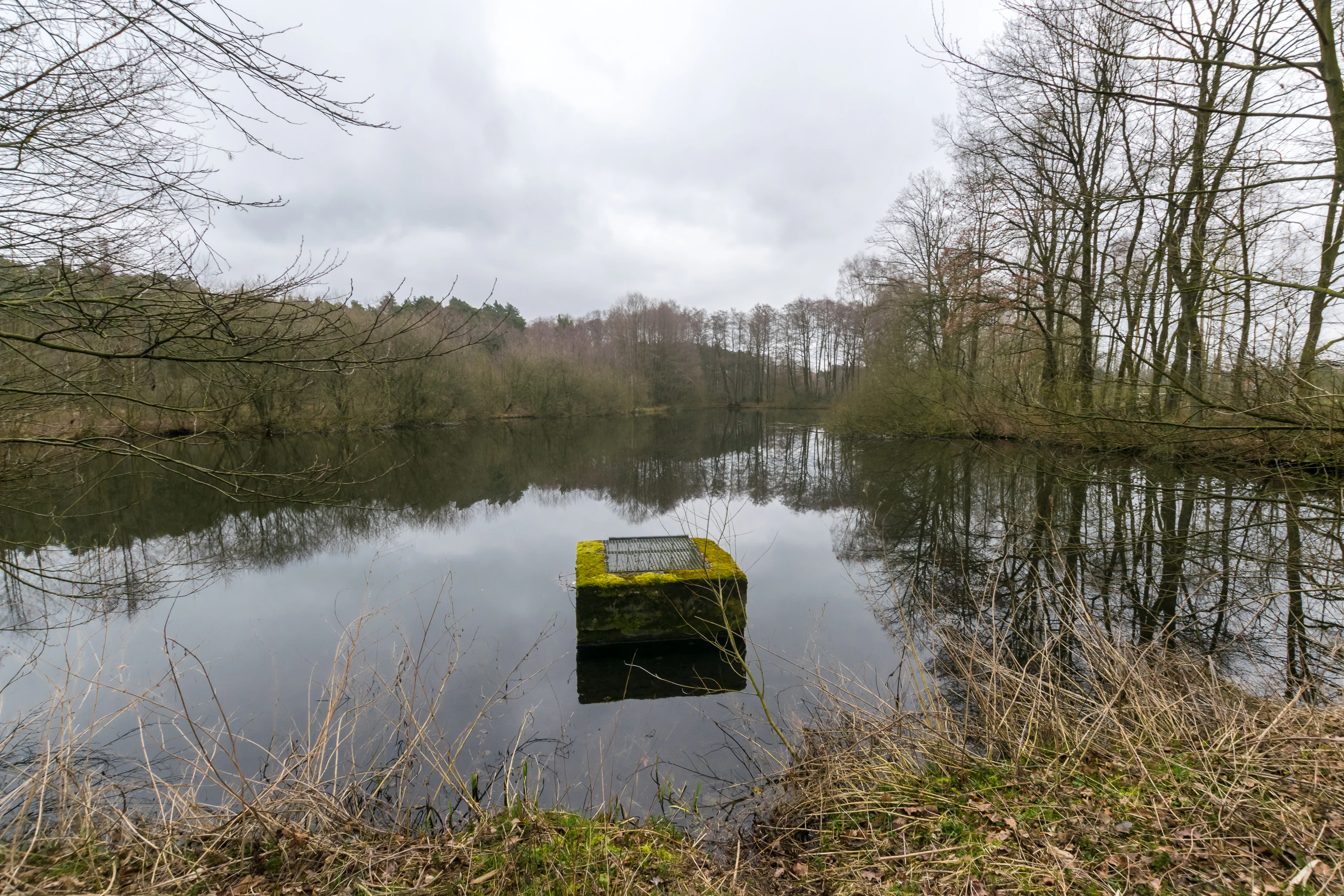
A square, moss-covered concrete overflow or water management structure sits in the middle of a still pond, surrounded by trees on an overcast day.
A moss-covered concrete structure sits in the calm waters of the Kipshagener Teiche nature reserve.

Kipshagener Teiche history and protected-area timeline

The exact origin of the Kipshagener Teiche is uncertain. While a documented dam concession dates to 1842, the ponds almost certainly existed long before that. The 1837 Prussian original survey shows that the reserve once contained a third pond below the western pond, roughly the same size as the western pond itself, with the modern alder swamp forest being considerably smaller at that time. The site's scientific and conservation interest emerged early, and leasing arrangements began with a 1925 contract between the former landowner, the Kipshagen estate, and the Naturwissenschaftlicher Verein Bielefeld, which secured the area for study, although an outright purchase by the association never materialized.

Even after protection arrived in 1937, the Kipshagener Teiche suffered ongoing disturbance. In 1932 a substantial heath-peat complex near the upper pond was covered with sand, the pond bed was limed and cleared, and a botanically valuable moor depression in what is now the reserve was destroyed. Post-war recreational pressure was heavy: the ponds were used for swimming, and water lilies and marsh gentians were reportedly sold at the Paderborn weekly market after being collected from the reserve. From 1942 onward, the nearby Epping company was permitted to dump waste and discharge wastewater, contributing to long-term degradation of the water and aquatic vegetation. Although a new, stronger protection regulation was enacted in 1970, the actually protected footprint was reduced to about 7.8 hectares at that time.

A turning point came at the end of 1989, when extensive restoration measures were launched. Part of one pond was separated by a dam to protect the transitional bog from further eutrophication, and in 1990 and 1991 a pre-settlement basin with gravel banks was constructed in front of the upper pond to improve water quality. The most sensitive areas of the reserve were additionally fenced off from visitors. These interventions established the framework for the modern management of the reserve under the lower landscape authority of the Kreis Gütersloh, with a renewed understanding of the Kipshagener Teiche as one of the oldest and most intensively studied protected sites in the Senne.

Kipshagener Teiche landscape and geographic character

The Kipshagener Teiche lies within the Senne, a sandy lowland framing the northern edge of the Teutoburg Forest region, where the broader landscape has long been shaped by dunes, heath, and former peatlands. The reserve itself occupies a depression that holds two ponds, set amid an unusual mosaic of wet and dry habitats. To the south, the boundary runs along tennis courts and football pitches, while the western edge of the protected area is defined by a high-voltage power line, an unmistakable modern marker in an otherwise quiet ecological niche.

Around the ponds the terrain transitions into the mires and wet heath that give the site its character. The upper pond is bordered by a small transitional bog, now fenced and actively managed to prevent woody encroachment as the water table has dropped. Lower in the sequence lies an alder swamp forest, with oak-birch woodland fragments and pine plantations rising onto sandy dunes where the heath has been replaced by forest. The layering of ponds, mire, wet heath, swamp forest, dune woodland, and surrounding pine plantations gives the reserve a compact but surprisingly varied topography within just over ten hectares.

Kipshagener Teiche ecosystems, habitats, and plant life

Ecologically, the Kipshagener Teiche preserves a layered sequence of wetland and dry habitats that together form one of the more botanically diverse small reserves in the Senne. The two ponds are strongly eutrophied and now retain only fragmentary shoreline communities, dominated by reed, yellow flag iris, broad-leaved cattail, various sedges, soft rush, hairy willowherb, and wild angelica. Despite this, the surrounding land still supports vegetation types that have become rare elsewhere in the region.

The most ecologically distinctive element is the small transitional bog at the edge of the lower pond, which retains a mosaic of wet heath and bog-like vegetation. Wet heath communities dominated by cross-leaved heath, common heather, and purple moor grass include bog whortleberry and deergrass, while cleared and scraped patches support oblong-leaved sundew, heath rush, and white beak-sedge. Along the margin of the wet heath, a near-raised-bog complex still harbours round-leaved sundew, bog rosemary, hare's-tail cottongrass, and common cranberry. Below the western pond, a well-developed alder swamp forest holds marsh fern, wild calla, marsh violet, elongated sedge, and royal fern, while drier areas support bilberry, lingonberry, wavy hair-grass, heather, and chickweed wintergreen.

Kipshagener Teiche wildlife and species highlights

Avifauna at the Kipshagener Teiche has been well documented through the work of Kuhlmann, with around 80 bird species recorded in the area and its surroundings. Species that once bred here include common snipe, marsh warbler, and northern lapwing. Today the little grebe still nests on the ponds, reflecting the continued importance of the open water and reed edges for waterbirds despite long-term habitat change.

The reserve is particularly notable for its dragonfly fauna. Among the species recorded are the common winter damselfly, the scarce emerald damselfly, the common hawker, and the downy emerald, all associated with well-vegetated ponds and bog-like margins. At the woodland edges, the sand lizard is present, occupying the transition between dry heath, dune woodland, and open sandy ground. Although much of the reserve's former rich fauna has declined with changes in water quality and vegetation, the combination of ponds, bog remnants, wet heath, and woodland edges continues to support a distinctive community of wetland and edge-of-habitat species.

Kipshagener Teiche conservation status and protection priorities

The Kipshagener Teiche is one of the oldest formally protected nature reserves in the Senne, with initial protection dating to 1937 and a renewed legal framework established in 1970. The reserve is currently classified as an IUCN Category IV Habitat/Species Management Area, reflecting its role in actively conserving specific habitats and species assemblages rather than functioning as a strictly left-alone wilderness preserve. Its protected status is administered by the Untere Landschaftsbehörde of the Kreis Gütersloh, and the site is registered in the World Database on Protected Areas under ID 82063.

The conservation history of the site is also a story of ecological recovery and ongoing vigilance. After decades of disturbance, including wastewater discharge, peat degradation, deforestation, and direct exploitation of rare plants, systematic restoration began at the end of 1989. The construction of a separating dam and pre-settlement basin was aimed at halting eutrophication, while fencing of the most sensitive areas limited further visitor damage. The reserve remains important for conservation because it preserves some of the last surviving examples of transitional bog, wet heath, and bog-like complexes in the Senne, along with their associated specialized flora and dragonfly fauna.

Kipshagener Teiche cultural meaning and human context

The Kipshagener Teiche takes its name from the historic Kipshagen farm, Hof Kipshagen, whose owners once held the surrounding land and entered into the earliest conservation agreements for the site. Early protection efforts in the 1920s were driven by the Naturwissenschaftlicher Verein Bielefeld, whose members conducted the first comprehensive botanical and zoological surveys of the area in 1933. The reserve thus occupies an important place in the regional tradition of citizen-driven natural history research in the Senne, long before ecological conservation became an established public policy.

Top sights and standout views in Kipshagener Teiche

The Kipshagener Teiche stands out as one of the oldest and most intensively studied nature reserves in the Senne, with formal protection stretching back to 1937. Its combination of artificial ponds, transitional bog, wet heath, alder swamp forest, and dune woodland creates a compact refuge for bog relicts such as round-leaved sundew, bog rosemary, common cranberry, and deergrass, as well as a diverse dragonfly community. The reserve's modern significance lies in the contrast between its long history of ecological damage and the substantial restoration efforts since 1989, which have made it a key reference site for understanding both the loss and partial recovery of wetland biodiversity in the region.

Best time to visit Kipshagener Teiche

The Kipshagener Teiche can be appreciated in any season, but late spring and summer bring the reserve's pond-side reedbeds, dragonflies, and wet heath into full life. Autumn offers a clearer view of the bog vegetation and heather communities as the surrounding pine forests change colour, while winter and early spring can be good for unobtrusive observation of waterbirds on the ponds. Visitors should be aware that the most sensitive bog and wet heath areas are fenced off from public access to protect the vegetation.

Monthly climate preview

Long-term representative point measurements tracking annual temperature and precipitation rhythms

Kipshagener Teiche Climate Normals and Measured Monthly Weather Patterns

Historical data records long-term average monthly temperatures ranging from near freezing to warm summer maximums alongside consistent year-round precipitation. Reviewing complete monthly climate normals reveals full seasonal shifts across the representative coordinate.
Annual mean9 °C
1 °C18 °C
Jan
Feb
Mar
Apr
May13°
Jun16°
Jul18°
Aug18°
Sep14°
Oct
Nov
Dec
Warmest month
July

18.1 °C

Coolest month
January

0.5 °C

Wettest month
December

2.6 mm/day

Driest month
April

1.6 mm/day

Park location guide

Geography guide, regional context, and park location map for Kipshagener Teiche

Kipshagener Teiche park geography, regions, and map view in Germany

Understand where Kipshagener Teiche sits in Germany through a broader geographic reading of the surrounding landscape, nearby location context, and its mapped position within the national park landscape.

How Kipshagener Teiche fits into Germany

Germany is a federal republic in Western and Central Europe with a population of over 83 million across sixteen constituent states. It is Europe's largest economy by nominal GDP and a major global exporter and importer. The capital is Berlin, and the country borders Denmark, Poland, Czech Republic, Austria, Switzerland, France, Luxembourg, Belgium, and the Netherlands.

Wider geography shaping Kipshagener Teiche in Germany

Germany is located in Western and Central Europe, spanning 357,022 km². It borders Denmark to the north, Poland and the Czech Republic to the east, Austria and Switzerland to the south, and France, Luxembourg, Belgium, and the Netherlands to the west. The country has coastlines on the Baltic Sea and North Sea to the north, with the Alps located in the southern region.

Map view of Kipshagener Teiche

Use this park location map to pinpoint Kipshagener Teiche in Germany, understand its exact geographic position, and read its mapped placement within the surrounding landscape more clearly.

Pigeon | © OpenStreetMap contributors

Location context for Kipshagener Teiche

North Rhine-Westphalia

Visualizing wetlands, transitional bogs, and protected reserve habitats

Kipshagener Teiche Photos and Landscape Scenery in the Senne Region

Visual records reveal the diverse terrain and delicate transitional bogs that define the protected landscape. Examining photographic views helps observers understand the environmental character and habitat mosaic preserved across the reserve.

A square, moss-covered concrete overflow or water management structure sits in the middle of a still pond, surrounded by trees on an overcast day.

Park atlas

Compare nearby regional reserves and connected wetland habitats across the Senne terrain.

Explore Parks Near Kipshagener Teiche and Surrounding Protected Landscapes

Browsing other parks near Kipshagener Teiche reveals broader regional patterns in wetland conservation and sandy lowland habitats. Comparing adjacent protected areas provides essential geographical context for understanding the wider Senne ecosystem.
A horizontal watercolor painting showing a small winding river flowing through a lush green forest with soft pink and yellow meadow areas in the foreground.
Nature reserveKreis Gütersloh
About 2.1 km away#1 closest

West

Holter Wald Nature Reserve: Mapping the Protected Woodland and Senne Landscape of Kreis Gütersloh

A major contiguous forest block on the eastern edge of the Westfälische Bucht

Situated in the district of Kreis Gütersloh, Holter Wald is a significant protected area defined by its sandy Senne soils and network of parallel brook valleys. The forest provides a critical lowland habitat for diverse flora and fauna, serving as a rare, large-scale woodland anchor within a largely agricultural region. Explore the terrain characteristics and ecological structure of this key North Rhine Westphalia site.

Area
6.13 km²
Established
2008
IUCN
IV
Relief
Lowland
A horizontal watercolor painting depicting a soft-toned landscape with scattered evergreen trees and undulating, sandy terrain under a light sky.
Nature reserveNordrhein-Westfalen
About 6 km away#2 closest

Southeast

Moosheide Nature Reserve: Mapping the Ancient Inland Dune Landscapes of Nordrhein-Westfalen

Protected heathland and spring-fed habitat geography.

Moosheide provides a focused look at the geomorphology of the western Senne region. This reserve protects some of the oldest inland dunes in northwestern Germany, alongside a rare juxtaposition of dry sandy grasslands and groundwater-dependent stream valleys that support high species diversity.

Area
4.427 km²
Established
1994
IUCN
IV
Relief
Lowland
A watercolor painting showing a soft, peaceful landscape with bare trees in the foreground, green trees in the midground, and distant hills under a pale sky.
Nature reserveNorth Rhine-Westphalia
About 9 km away#3 closest

Northwest

Kampeters Kolk Nature Reserve: Geographic Overview and Protected Wetland Boundaries

Senne region heath pond and wetland mosaic in North Rhine-Westphalia

Kampeters Kolk preserves a significant fragment of the historic Senne heath landscape in North Rhine-Westphalia. The reserve centers on a small, artificial pond created by peat extraction, now surrounded by a rich sequence of sedges, reed stands, and willow-alder shrub thickets that provide critical habitats for local amphibian populations.

Area
0.02 km²
Established
1993
IUCN
IV
A soft watercolor illustration featuring rolling green hills, a small grouping of trees on the right, and open grassy terrain on a white background.
Protected areaNordrhein-Westfalen
About 9.7 km away#4 closest

Southeast

Senne mit Teutoburger Wald: Protected Habitat and Regional Geography Atlas

Heathland and forest ecosystems in North Rhine-Westphalia

This protected area presents a unique geographic profile, merging expansive lowland heath and dune systems with the wooded slopes of the Teutoburg Forest. Its distinct ecological gradient and significant size make it a critical site for habitat conservation, bird protection, and study of transition zones between sandy plains and mountain ridges.

Area
153.597 km²
Established
2001
Relief
Mixed relief
Climate
Temperate
Nature reserveNordrhein-Westfalen
About 12 km away#5 closest

North

Windwehetal Nature Reserve: Mapped Protected Brook Valley in Nordrhein-Westfalen

Dynamic stream geography and woodland protected landscapes

Windwehetal represents a compact yet ecologically significant protected area in the German federal state of North Rhine-Westphalia. The reserve showcases near-natural stream dynamics, including undercut slopes reaching three metres, alongside a complex mosaic of gallery woodlands, damp grasslands, and beech forests that define the valley floor and surrounding ridges.

Area
0.565 km²
Established
1998
IUCN
IV
Relief
Upland
Nature reserveNordrhein-Westfalen
About 13 km away#6 closest

North

Windweheniederung Nature Reserve: Geographic Atlas of an East Westphalian Floodplain

Riparian ecosystems and protected valley land mapping

Windweheniederung represents a specialized nature reserve in Nordrhein-Westfalen that centers on the natural morphology of the Windwehe stream. This protected area provides a critical refuge for wetland-dependent species through its alder-ash woodland and reed-fringed pools. Explore the structural geography of this lowland catchment and understand its role in maintaining functional floodplains amidst a heavily developed regional environment.

Area
0.297 km²
Established
1991
IUCN
IV
Protected landscapeKreis Paderborn
About 14 km away#7 closest

South

Landschaftsschutzgebiet Delbrücker Rücken Protected Landscape Map and Regional Context

A rural ridge mosaic in the Kreis Paderborn district

This protected landscape in the Kreis Paderborn district features a characteristic mix of deciduous forests, field hedgerows, and agricultural zones on a gentle Westphalian ridge. Its geographic layout provides a clear example of rural land protection integrated into the local environmental buffer system, showcasing a distinct mosaic of terrain that stretches across the lands north and east of Delbrück.

Area
16.1 km²
Established
1970
Relief
Lowland
Climate
Temperate
A pale, soft-toned watercolor painting of a rolling landscape with green fields, forested areas, and a small winding stream under a light sky.
Nature reserveNordrhein-Westfalen
About 15 km away#8 closest

Northeast

Holzhauser Bruch Nature Reserve: Protected Wetland and Riparian Geography in Nordrhein-Westfalen

Mapping lowland bog and meandering river corridors

Holzhauser Bruch in Nordrhein-Westfalen preserves a compact yet ecologically vital riverine landscape. Its terrain contrasts wet alder-dominated swamp forests with drier, sandy upland slopes. This summary explores the geographic boundary of the reserve, highlighting its role as a representative fragment of the Werre valley habitat system.

Area
0.4 km²
Established
2002

Common questions about visiting, size, designation, and location context for Kipshagener Teiche

Kipshagener Teiche FAQs for park facts, access, geography, and protected area context

Find quick answers about Kipshagener Teiche, including protected-area facts, park geography, trail and visitor context, and how the park fits into its surrounding country and regional landscape.
MoriAtlas Explorer

Continue Your Protected Areas Search Across the Global Atlas

Deepen your exploration by continuing the structured search for national parks and protected areas worldwide. Utilize the comprehensive filtering capabilities to compare different conservation landscapes and refine your understanding of global park geography. Discover more about the distribution and characteristics of protected natural areas.

Global natural geography